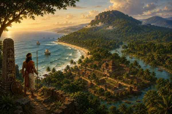
Mahabharata Geography — Mushika
Modern geographical correspondence: Northern Kerala, especially the Kannur–Kasaragod region, India
On the far southwestern edge of Bharata, where the mountains of the Western Ghats descend towards a narrow green plain facing the Arabian Sea, ancient geographical tradition remembered a people called the Mushikas. Their country belonged to a landscape very different from the Gangetic plains familiar from much of the Mahabharata. Here monsoon clouds gathered against mountain walls, short powerful rivers rushed westwards towards the sea, coconut and other tropical vegetation covered the lowlands, and a chain of coastal settlements connected the interior forests with the maritime world of the Indian Ocean.
The Mahabharata itself places the Mushikas among the peoples of southern India, listing them alongside the Keralas and Vanavashikas in its great geographical description of Bharatavarsha. Later historical and literary traditions associate the Mushika name particularly strongly with Ezhimala and northern Malabar, centred in what are today Kannur district and adjoining parts of Kasaragod. This later evidence provides the strongest basis for identifying the epic Mushika country broadly with northern Kerala, although the identification should be treated as a geographical reconstruction rather than as a precisely proven epic-period boundary.
Mushika in the Mahabharata
The clearest reference to Mushika occurs in the Bhishma Parva, during the description of the peoples and countries occupying Bharatavarsha. The text moves through an enormous catalogue stretching across the subcontinent and then turns towards the south, naming the Dravidas, Keralas, Prachyas, Mushikas and Vanavashikas, followed by Karanatakas, Mahishakas, Kuntalas, Cholas and numerous other peoples. The placement is important because it firmly establishes the Mushikas within the southern geographical world recognised by the epic.
The wording also provides an important clue to their location. Mushika appears immediately in a group containing Kerala and Vanavasi, regions that can be placed along the southwestern and western sides of peninsular India. Vanavasi belonged to the forested Karnataka interior around Banavasi, while Kerala lay along the Malabar side of the Western Ghats. Mushika therefore fits naturally somewhere within this southwestern geographical zone.
There is, however, a textual complication. The same catalogue contains forms rendered by Ganguli as both Mushikas and Mushakas, and similar repetitions appear in the Vishnu Purana’s geographical list. Such variation may reflect separate names, scribal transmission or different traditions preserved within ancient geographical catalogues. It would therefore be unsafe to use the list alone to draw a precise Mushika boundary.
What the Mahabharata gives us with considerable confidence is the larger geographical fact: the Mushikas belonged to southern Bharata.
From the Epic Name to Northern Kerala
The identification becomes much clearer when later Kerala history is considered. Kerala Tourism’s official account of Ezhimala, the prominent hill near Payyanur in Kannur district, states that the region was the headquarters of the ancient Ezhimala rulers and later of the Mooshika kings. The same region had a long history stretching back to the Sangam period and formed an important centre on the northern Malabar coast.
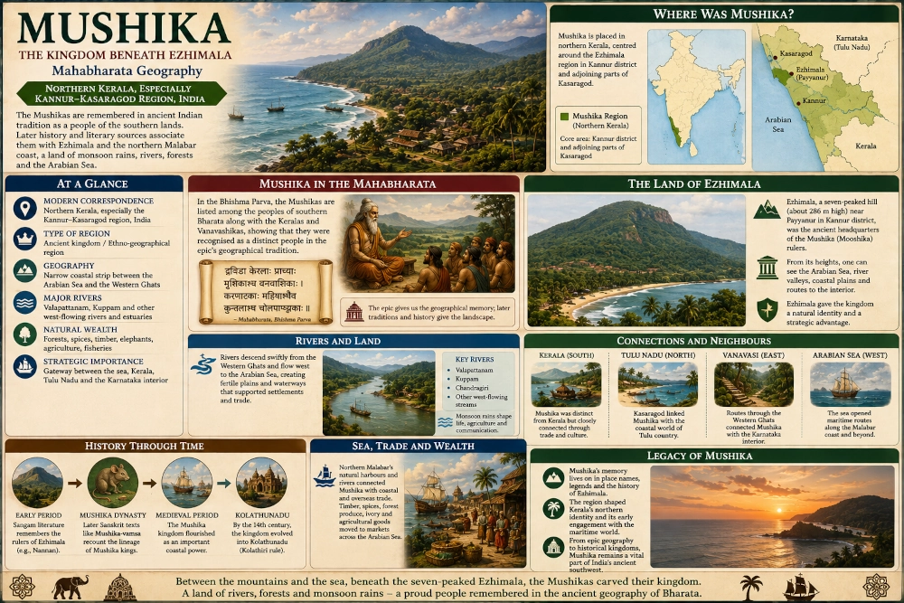
A much later Sanskrit work, the Mushika-vamsa, provides an especially important bridge between the Mushika name and northern Kerala. Composed by the poet Atula around the eleventh century, it recounts the genealogy and legendary history of the Mushika rulers whose kingdom lay around Ezhimala. Kerala historical scholarship consequently associates the medieval Mushika kingdom with the earlier Ezhimala political tradition.
This does not prove that every Mushika mentioned in every Sanskrit text must refer to exactly the same territory. Indeed, older geographical scholarship sometimes placed Mushika farther south along the Malabar coast. The stronger regional tradition preserved around Ezhimala, however, makes northern Kerala—particularly Kannur and the southern and central portions of Kasaragod—the most useful modern correspondence for a Mahabharata Geography reconstruction.
Ezhimala — The Mountain Above the Mushika Coast
No landscape feature is more closely associated with the historical Mushika country than Ezhimala.
The mountain rises dramatically near the Arabian Sea in present-day Kannur district, approximately seven kilometres from Payyanur. Kerala Tourism describes Ezhimala as a seven-peaked mountain reaching about 286 metres above sea level. Although modest compared with the great interior ranges of India, its position close to the coast gives it exceptional visual prominence. From its heights, the Arabian Sea and the surrounding northern Kerala countryside spread out below.
For ancient travellers, such a mountain would have been far more important than its absolute height suggests. Sailors approaching the Malabar coast could identify prominent headlands and hills long before individual settlements became visible. Travellers moving through the coastal plains likewise used hills, rivers and distinctive rock formations as natural geographical markers.
Ezhimala therefore formed both a physical and symbolic centre of the country. Forested slopes rose above a landscape of waterways, cultivation and coastal settlements, while the sea lay only a short distance away. The prominence of the mountain in later Mushika tradition suggests that political identity and geography became closely intertwined here.
A traveller approaching the region from the south might first have seen the dark outline of Ezhimala rising above groves of trees. During the monsoon its summit would disappear beneath clouds, while heavy rain swept inland from the Arabian Sea. During clearer months, the hill could serve as an unmistakable landmark dominating the northern Malabar coast.
Between the Arabian Sea and the Western Ghats
The geographical character of Mushika was shaped by an extraordinary compression of landscape. Unlike the broad river plains of northern India, northern Kerala occupies a relatively narrow strip between the Arabian Sea in the west and the Western Ghats in the east.
Within a comparatively short distance, a traveller could move from sandy beaches and estuaries through fertile lowland cultivation into wooded foothills and finally towards mountain country. Rivers descended rapidly from the eastern uplands and travelled westwards towards the sea, creating valleys that served as natural corridors through the region.
This geography gave the Mushika country two orientations simultaneously. The eastern side connected it with the highlands of present-day Karnataka, Kodagu and Wayanad, while the western side opened directly towards the maritime networks of the Arabian Sea.
The region was therefore never an isolated coastal strip. Forest paths, river valleys and mountain passes connected it with the interior, while boats linked its shores with distant ports.
The Rivers of Northern Malabar
Water dominates northern Kerala. Rivers such as the Valapattanam, Kuppam and other west-flowing systems descend from the Western Ghats or adjoining uplands and reach the Arabian Sea after relatively short journeys. Their lower courses form broad channels, wetlands and estuarine environments that have shaped settlement for centuries.
The later medieval Mushika country is specifically associated in historical scholarship with the river systems around northern Kerala. These waterways linked inland agricultural and forest regions with coastal settlements and helped create the geographical coherence of the northern Malabar political landscape.
In the ancient world, such rivers functioned almost like roads. Transporting heavy goods by boat could be far easier than carrying them along narrow paths through humid forest. Timber, spices, agricultural produce and other goods could move downstream towards coastal markets, while imported commodities travelled inland.
During the monsoon, however, the same rivers could become dangerous. Torrential rain falling across the Western Ghats rapidly increased their volume. Floodwaters spread across low-lying areas, while swollen streams made overland journeys difficult.
Life in Mushika therefore required continuous adaptation to water.
A Country of Monsoon Rains
Few environmental forces would have shaped Mushika more completely than the southwest monsoon.
Each year moisture-laden winds from the Arabian Sea strike the western side of the Indian peninsula, releasing enormous quantities of rain across the Malabar coast and the Western Ghats. The landscape responds almost immediately. Rivers swell, hill slopes turn brilliant green, forest growth becomes dense and cultivated land fills with water.
For a visitor arriving from drier regions of the Deccan or northern India, the environment would have appeared extraordinarily lush. Trees grew thickly along watercourses. Vines climbed through forest vegetation. Rice fields occupied wetter lowlands while settlements clustered on slightly raised ground.
The monsoon also influenced warfare and political communication. Large armies could not move through saturated terrain as easily as they could across dry plains. Mountain passes became difficult, rivers required careful crossing and roads deteriorated rapidly.
Geography therefore offered northern Malabar a degree of natural protection. Controlling Mushika required understanding a landscape of rain, rivers, forests and hills.
The Sea Before Mushika
The Arabian Sea formed the western horizon of the Mushika country and connected northern Kerala with one of the oldest maritime networks in the world.
Later historical evidence demonstrates that Ezhimala and the northern Malabar coast became deeply involved in overseas commerce. Kerala Tourism describes Ezhimala as an ancient trading centre that was visited by Arab merchants, while the wider Malabar coast became famous in subsequent centuries for maritime exchange.
Care is necessary when applying this later evidence to the world of the Mahabharata. We cannot simply assume that the medieval trading system already existed in exactly the same form during the period remembered by the epic. The geography, however, made maritime activity almost inevitable.
Protected river mouths, beaches suitable for landing smaller craft and prominent coastal landmarks gave the region natural advantages. Coastal boats could move between settlements along the Malabar shore, while larger vessels could eventually connect the region with western India and the wider Indian Ocean.
For Mushika, the sea was not the edge of the inhabited world. It was another road.
Mushika and Kerala — Neighbours, Not Necessarily Identical
One of the most important geographical clues in the Mahabharata is that Keralas and Mushikas are named separately. This suggests that the epic tradition could distinguish between the two populations rather than using Mushika merely as another word for Kerala.
In our reconstruction, Kerala represents the broader southwestern region extending farther south along the Malabar side of the peninsula, while Mushika occupies its northern coastal zone around Ezhimala.
This distinction fits later political history as well. Northern Malabar repeatedly developed political identities different from those of central and southern Kerala. Kerala Tourism notes that the political history of Malabar can be traced to the Ezhimala kingdom and that the later Mushika kingdom eventually developed into Kolathunadu.
The boundary between Mushika and neighbouring Kerala should not be imagined as a modern state border. Ancient regional identities were fluid, and rulers could extend their influence south or north according to military strength.
Nevertheless, the separate appearance of the two names is valuable. It reminds us that ancient Kerala was not necessarily one unified political territory.
Mushika and Tulu Country
The northern side of Mushika opened towards another important cultural landscape: Tulu country, corresponding broadly to the coastal districts around present-day Mangaluru and southern Karnataka.
Kasaragod forms the transitional zone between Kerala and Tulu Nadu even today. Kerala Tourism’s history of Kasaragod notes that the northernmost parts of the modern district were historically associated with Tuluva rulers, while central and southern portions later came under the Chirakkal or Mushika-Kolathiri political tradition.
This transition probably has very ancient roots.
The Mushika country should therefore not be visualised as abruptly ending at today’s Kerala-Karnataka border. Northern Malabar and the southern Karnataka coast formed an interconnected cultural and economic zone linked by rivers, hill passes, marriage alliances and maritime travel.
For ancient Mushika, the north was therefore not an empty frontier. It led directly into another thriving coastal civilisation.
Mushika and Vanavasi
The Mahabharata’s geographical catalogue places the Mushikas close to the Vanavashikas, another significant clue. Vanavasi belonged to the Karnataka interior centred around Banavasi and the forested country east of the coastal ranges.
The Western Ghats separated these regions physically but did not isolate them completely. Passes through the mountains allowed communication between the Malabar coast and Karnataka. Forest products, animals, metals and other goods could move west towards coastal markets, while salt and maritime commodities travelled inland.
This relationship makes northern Kerala an especially plausible location for Mushika. From the Kannur-Kasaragod region, routes eastwards reach the uplands of Kodagu and Karnataka, while routes northward approach the Tulu coast.
Mushika therefore sat at a geographical crossroads between Kerala, Tulu Nadu, Vanavasi and the Arabian Sea.
Forest Wealth and the Mountain Interior
Behind the coastal settlements stretched the forested hills of northern Kerala and the Western Ghats. These forests contained timber, medicinal plants, honey, wildlife and numerous other natural resources.
They also connected the region with one of the commodities for which the Malabar coast would eventually become famous: spices.
Pepper and other forest-linked products later became enormously valuable in Indian Ocean trade. Although their precise commercial importance during the epic age cannot be reconstructed securely, the ecological conditions that made northern Kerala productive were already present.
The hills also contained important elephant habitats. Elephants moved through forest corridors linking Kerala with Karnataka and the interior Ghats, while rulers throughout ancient and medieval South India valued elephants for prestige, labour and warfare.
The Mushika ruler therefore governed not simply coastal fields but a complex economic world stretching into forests and mountains.
Early Ezhimala and the Sangam World
The historical picture becomes considerably clearer during the early centuries of the Common Era, when Tamil Sangam literature remembers the rulers of Ezhimala. Kerala Tourism likewise identifies Ezhimala’s political history with the Sangam age, long before the better documented medieval Mushika dynasty.
One of the most famous rulers associated with Ezhimala was Nannan, a name appearing prominently in early Tamil literature. The northern Malabar polity participated in the political struggles of ancient Tamilakam and interacted with neighbouring Chera rulers.
This evidence is significant because it demonstrates that northern Kerala possessed its own recognised political centre at a relatively early historical date. It therefore becomes easier to understand how a Sanskrit geographical tradition could preserve the name of a separate southern people corresponding to this region.
We should still resist equating every early Ezhimala ruler directly with the Mushikas of the Mahabharata. The chronology and textual histories are too complex for such certainty. What the Sangam evidence provides is geographical continuity: northern Malabar was indeed capable of supporting a distinctive political tradition.
The Mushika-vamsa and the Memory of a Dynasty
Centuries after the epic tradition had taken shape, the Sanskrit poet Atula composed the Mushika-vamsa Mahakavya. The poem recounts the legendary origins and genealogy of the Mushika rulers of northern Kerala and is generally dated to around the eleventh century. Kerala Tourism describes it as a historical poem relating the history of the Mushika kingdom, while scholarship identifies Atula as a court poet of a Mushika ruler.
The work is extremely valuable but must be used with caution. Its earliest genealogical sections combine royal mythology with political memory, while later portions move closer to historically identifiable rulers. The Mushika-vamsa was written to glorify a dynasty, not to provide modern critical history.
Nevertheless, its existence is remarkable.
Here was a ruling family in northern Kerala that deliberately preserved the name Mushika and constructed an elaborate Sanskrit genealogy around it. That continuity is one of the strongest reasons historians connect the ancient geographical name with the Ezhimala region.
The Legend of the Mouse
The Sanskrit word mushika means mouse or rat, and the Mushika-vamsa developed a legendary explanation for the royal name. According to the poem’s mythic narrative, an ancestral queen encountered a supernatural rat associated with the Ezhimala region. The creature was ultimately released from a curse, and the event became woven into the legendary origin of the dynasty.
Such stories should be understood as dynastic mythology rather than literal history. Medieval royal houses throughout India developed elaborate origin traditions connecting themselves with gods, sages, heroic lineages or miraculous events.
What makes the Mushika story fascinating is the way it attaches the dynasty directly to the landscape of Ezhimala. Mountain, royal lineage and name become elements of a single sacred geography.
The later legend therefore preserves something historically meaningful even if its events are mythical: the Mushika rulers regarded their identity as inseparable from the northern Kerala country they governed.
From Mushika to Kolathunadu
The Mushika political tradition continued to evolve during the medieval period. Kerala Tourism records that by around the fourteenth century the Mushika kingdom had become known as Kolathunadu, with its rulers called the Kolathiris.
Kasaragod likewise came partly within this northern Kerala political sphere. Kerala Tourism notes that central and southern Kasaragod were historically connected with the Chirakkal or Mushika-Kolathiri royal family, while Nileshwaram became an important centre within the later regional system.
The changing names illustrate a principle encountered repeatedly throughout Mahabharata geography. Regions rarely preserve one political identity forever. Mushika became connected with Ezhimala, the later polity evolved into Kolathunadu, and still later rulers and principalities divided the northern Malabar landscape.
Yet the underlying geography remained remarkably stable.
The Arabian Sea remained in the west. The Ghats continued to rise in the east. Rivers flowed down between them, and Ezhimala continued to dominate the coast.
The Question of Mushika’s Exact Boundaries
Drawing an exact map of Mahabharata Mushika would create a false impression of certainty.
The epic itself tells us that Mushika belonged among the southern countries, but it does not state that its northern boundary followed a particular river or that its southern frontier stood at a named settlement. Later Mushika rulers controlled territory around northern Kerala, but their political boundaries changed over hundreds of years.
Our identification should therefore be understood as a geographical correspondence rather than a territorial equation.
The most convincing core lies around Ezhimala, Payyanur, Kannur and adjoining northern Malabar, with the wider cultural and political zone extending northwards into portions of modern Kasaragod and at different periods southwards through other parts of Kannur.
The mountainous eastern hinterland would also have been important. Coastal kingdoms depended upon the forests, passes and river valleys behind them, meaning that Mushika’s influence probably extended eastward considerably beyond the immediate shoreline.
Mushika in the Landscape of the Mahabharata
Picture the country at the beginning of the monsoon. The Arabian Sea darkens beneath enormous clouds while waves break heavily against the Malabar shore. Rain begins falling upon Ezhimala, covering its forested slopes in mist. Streams descending from the hills swell rapidly and flow towards broad estuaries bordered by thick tropical vegetation.
Along the riverbanks stand settlements surrounded by rice fields, palms and groves. Small craft move between landing places carrying people and produce. Inland routes disappear beneath trees before climbing towards the Western Ghats, where hunters, forest communities and traders know paths leading towards Karnataka and Kodagu.
From the heights of Ezhimala, the political geography of the region becomes almost visible. To the west stretches an apparently limitless sea. To the north lies the approach towards Tulu Nadu. To the east rise the mountain routes towards Vanavasi and the Karnataka interior. To the south stretches the long Malabar coast towards the wider Kerala country.
This is the geographical setting in which Mushika makes sense.
The Northern Gateway of Kerala
Mushika’s importance came from occupying Kerala’s northern gateway.
An army moving south along the western coast from Tulu country would encounter this region before reaching the central Malabar territories. A merchant arriving by sea could use its river mouths to reach inland settlements. Travellers crossing the Ghats could emerge onto the coast through routes connecting the Karnataka uplands with northern Kerala.
Such geography encouraged both independence and interaction.
The Mushika rulers could develop a distinct political identity because their country was separated from central Kerala by distance and local geography. Yet they could never isolate themselves completely because maritime routes and mountain passes connected them continually with neighbouring regions.
This helps explain why northern Malabar would repeatedly develop strong regional dynasties throughout history.
Mushika — The Kingdom Beneath the Seven-Peaked Hill
The Mushika of the Mahabharata is not described through dramatic battlefield episodes or lengthy stories about individual kings. Its importance lies instead in the epic’s geographical memory. When the Bhishma Parva surveys the southern lands of Bharata, Mushika is there, recognised separately from Kerala and placed within the great mosaic of southern peoples.
Later history gives that name a landscape. Ezhimala in Kannur became the headquarters of rulers remembered as the Mooshikas, while the Mushika-vamsa preserved the genealogy and royal traditions of a dynasty centred in northern Kerala. The succeeding political world of Kolathunadu continued to occupy Kannur and substantial portions of the Kasaragod region.
For our Mahabharata geography, Mushika can therefore be reconstructed most plausibly as a northern Malabar kingdom centred upon the Ezhimala–Kannur region and extending into adjoining Kasaragod, bounded conceptually by the Arabian Sea in the west and the forested approaches to the Western Ghats in the east.
Its landscape was one of powerful contrasts. Mountains rose almost beside the sea. Monsoon rivers crossed fertile plains in only a few dozen kilometres. Forest routes reached the Karnataka interior, while coastal waters opened towards the wider Indian Ocean.
If Kalinga represented the eastern kingdom where mountains approached the Bay of Bengal, Mushika occupied its geographical counterpart on India’s western coast—a green, rain-fed country beneath Ezhimala where the Western Ghats looked down upon the Arabian Sea.
And although the rulers who once governed this country have disappeared, the geography that shaped them remains unmistakable. From the summit of Ezhimala today, one can still look west across the Arabian Sea and east towards the hills and understand why this narrow, fertile and strategically placed corner of northern Kerala could sustain a political identity remembered in India’s ancient geographical tradition.
You may also like
-
Tosala — The Ancient Heartland of the Daya, Mahanadi and Odisha’s Coastal Plain
-
Odra — The Mahanadi Country of Forested Hills and River Valleys
-
Utkala — The River-Bound Eastern Land Between the Highlands and the Sea
-
Kalinga — The Eastern Kingdom Between Mahendra and the Sea
-
PM Vishwakarma Reaches 30-Lakh Artisan Registration Target as Scheme Completes Three Years
