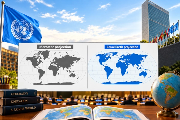
The United Nations General Assembly has overwhelmingly adopted a resolution calling for more accurate representation of the relative size of the world’s continents, challenging the continued widespread use of map projections that visually enlarge some regions while making Africa, Latin America and South Asia appear smaller than they really are.
The resolution, titled “Correct the map: rebalancing global cartographic representation and promoting equitable representation of the world’s regions, particularly Africa,” was adopted on September 4, 2026, by 164 votes in favour, one against and six abstentions. The United States cast the only vote against the resolution, while Estonia, Georgia, Lithuania, Moldova, Serbia and Ukraine abstained. India voted in favour.
The initiative was introduced by Togo on behalf of the African Group, following a wider African campaign to encourage the use of map projections that better preserve the actual relative areas of continents. Togo’s diplomatic mission described the vote as a major step toward correcting distortions inherited from traditional cartographic practices.
Why the Mercator Projection Is Under Scrutiny
At the centre of the debate is the Mercator projection, developed by Flemish cartographer Gerardus Mercator in 1569. It was designed primarily for navigation because it preserves angles and directions, allowing sailors to plot constant compass bearings as straight lines.
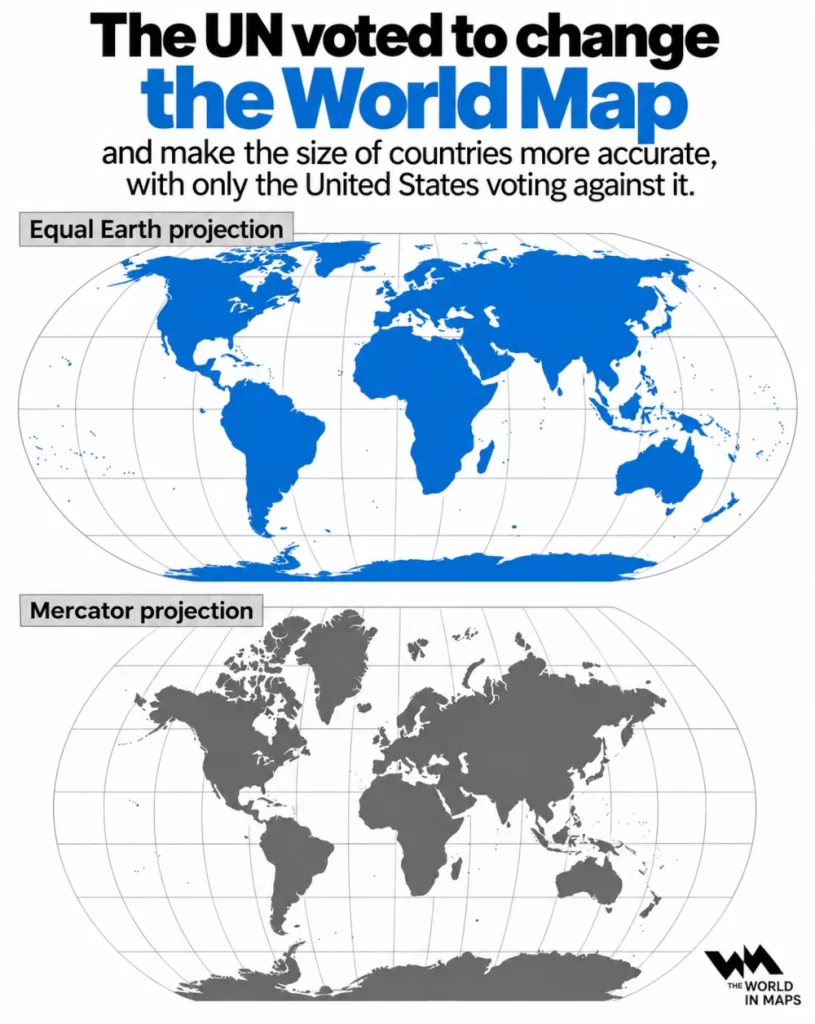
That advantage comes with an important drawback. The farther a landmass lies from the equator, the more its apparent area is enlarged on the map. As a result, northern regions such as Greenland, northern Europe and Canada appear disproportionately large, while areas closer to the equator appear relatively diminished.
One of the clearest examples is the comparison between Greenland and Africa. Greenland covers roughly 2.16 million square kilometres, while Africa covers around 30.3 million square kilometres. Africa is therefore about fourteen times larger, even though the two can appear surprisingly similar in size on a Mercator world map.
India, at approximately 3.29 million square kilometres, is itself larger than Greenland, another relationship that is not always visually obvious on Mercator-based maps.
The UN General Assembly said commonly used projections have contributed to distorted perceptions of the scale of Africa and other regions and noted their continuing presence in educational material, media, digital platforms and official publications.
Resolution Calls for Wider Use of Equal-Area Maps
Rather than imposing one compulsory world map, the resolution encourages wider use of equal-area projections in situations where accurately comparing the size of countries and continents is important.
Equal-area projections preserve the proportional area of geographical regions. They still distort other characteristics, such as shape, distance or direction, because no flat map can reproduce a spherical Earth without some form of distortion.
The resolution specifically identifies the Equal Earth projection as one useful option. Equal Earth was introduced in 2018 and was designed to provide a visually balanced world map while accurately representing relative land areas.
The official UN meeting summary says the resolution calls for wider use of equal-area projections, particularly Equal Earth, where comparative continental size is relevant.
However, the resolution does not ban the Mercator projection, nor does it require governments to abandon it for applications where its particular characteristics remain useful.
India Supports the Principle but Rejects a Single Mandatory Projection
India supported the resolution while making an important clarification about how it should be interpreted.
First Secretary Raghoo Puri of India’s Permanent Mission to the United Nations said India welcomed efforts to promote more accurate and representative cartographic practices because maps influence how societies understand geography and the relative scale of different parts of the world.
India’s position was that the resolution should be understood as encouraging the broader use of equal-area map projections, rather than endorsing Equal Earth or any other single projection as the universal standard. India argued that different map projections serve different purposes and that no one projection is necessarily appropriate for every application.
Equal-area maps are particularly useful when the objective is to compare territorial size because they maintain the correct proportional relationship between landmasses. Other projections may instead prioritise navigation, shape, direction or distance.
India therefore backed the principle of correcting misleading representations of relative landmass size while emphasising technological and methodological neutrality.
India Wants Cartographers to Retain Flexibility
India’s intervention adds an important technical dimension to the resolution.
A world map is created by transforming a three-dimensional globe onto a two-dimensional surface, which inevitably introduces distortion. Cartographers therefore choose projections depending on what a particular map is intended to show.
A navigation map may prioritise direction. A thematic map comparing population or land area may benefit from an equal-area projection. Other maps may attempt to preserve shape or distance.
India’s position is that institutions, countries and cartographers should be free to choose the projection best suited to the intended purpose, while giving greater consideration to equal-area approaches when accurate comparison of territorial size is important.
This avoids replacing one universal cartographic convention with another while still addressing the specific distortion that prompted the UN initiative.
Africa Led the Push to ‘Correct the Map’
The resolution emerged from an African-led campaign that argued the traditional representation of the continent on many world maps had consequences extending beyond geography.
Togo introduced the initiative on behalf of the African Group. Its representatives argued that maps influence education, collective perception and the way societies understand the importance and scale of different regions.
Togo’s official diplomatic account of the vote said the initiative seeks greater diversity in cartographic projections used in education, more scientifically balanced representations in media and digital platforms, and more accurate geospatial information for development and policy.
The campaign has been supported by the African Union, which has promoted the Equal Earth projection as an alternative for situations where accurate representation of continental area is important.
Introducing the proposal, the Togolese representative told the General Assembly that correcting cartographic distortion was not directed against any country or cartographic tradition but was intended to encourage projections that more faithfully preserve the proportions of continents.
South Asia Also Affected by Projection Distortion
Although Africa is at the centre of the initiative, the resolution also has relevance for South Asia and Latin America.
Regions closer to the equator are relatively diminished on Mercator maps when compared with northern landmasses. Countries across South Asia can consequently appear smaller in visual comparison with territories at higher latitudes.
For India, supporting equal-area representation therefore reflects both the broader principle of accurate cartography and the geographic reality that South Asia is among the regions whose perceived scale can be affected by traditional projection choices.
The resolution frames these distortions as having potential educational, cultural and geopolitical consequences because generations of students may build an intuitive understanding of the world partly from the maps they repeatedly see.
What the UN Resolution Does Not Do
The resolution does not redraw any international boundary, change territorial sovereignty or determine ownership of disputed territory.
A map projection concerns the mathematical method used to represent the curved surface of the Earth on a flat map. Political boundaries are a separate issue.
The resolution is also non-binding. Member States are encouraged rather than legally required to change the maps used in schools, government documents, media or digital systems.
It does not abolish Mercator for navigation, aviation or other specialised applications where its properties may still be useful.
This distinction is important because some descriptions of the vote have suggested that the UN has adopted a single replacement “world map.” The actual decision is broader and more flexible: it promotes more accurate representation of landmass size and encourages the use of equal-area projections where appropriate.
United States Casts the Only Vote Against
The United States was the only member of the General Assembly to vote against the resolution.
Washington argued that the General Assembly should focus on issues it considered more directly related to international peace, prosperity and institutional effectiveness rather than debates over historical cartographic representation.
Despite that opposition, the scale of support was substantial. With 164 countries voting in favour, the resolution received backing from a large majority of the UN membership.
The six abstaining countries were Estonia, Georgia, Lithuania, Moldova, Serbia and Ukraine.
Classroom Maps Could Gradually Change
The most visible long-term effect of the resolution could come through education, publishing and digital mapping.
Schools and universities may increasingly use equal-area world maps when teaching comparative geography. Publishers and media organisations could also reconsider the default projections they use for global illustrations.
Digital platforms have even greater flexibility because maps can change projection depending on zoom level and intended purpose rather than relying on one static representation.
Any transition is likely to be gradual because Mercator and related projections are deeply embedded in mapping systems and remain technically useful for certain tasks.
Nevertheless, the UN vote gives political and institutional weight to a movement that has been building for years among geographers, educators and African governments.
A Debate About How the World Is Seen
The significance of the “Correct the Map” resolution extends beyond cartographic technique. It reflects a wider debate about how visual conventions shape perceptions of geography, economic importance and political scale.
A map cannot change the physical size of Africa, India or any other region. But the way those places are presented can influence how people intuitively compare them.
The UN resolution therefore seeks to encourage cartography that better distinguishes between maps designed for navigation and maps intended to show the world’s regions in their true relative proportions.
India’s vote adds a carefully balanced position to that effort. New Delhi supports wider use of equal-area maps where relative size matters, while resisting the idea that one particular projection should become compulsory for every purpose.
The result is not the adoption of a single new world map. It is a push toward a more informed approach to cartography in which the projection is chosen according to purpose and the true relative scale of continents is given greater weight.
You may also like
-
Tarang Shakti Delegates from 28 Countries Visit HAL and BEL to Explore India’s Defence Manufacturing Ecosystem
-
Swiss President Guy Parmelin to Visit India as EFTA Economic Partnership Deepens
-
Defence Accounts Department Launches SAKSHAM Integration, PRISM and Revamped National Compilation System
-
India and Brazil Move to Expand Mercosur Trade Pact Beyond 450 Tariff Lines
-
India and Qatar Accelerate FTA and Investment Treaty Talks
