Mahabharata Geography — Setu
Modern geographical correspondence: Rameswaram, Pamban Island, Dhanushkodi and the coast facing Sri Lanka, Tamil Nadu, India
At the southeastern edge of the Tamil country, the Indian peninsula appears almost to dissolve into the sea. Long sand spits narrow towards the horizon, shallow turquoise waters stretch between reefs and shoals, and beyond them lies Sri Lanka. Around Rameswaram, Pamban Island and Dhanushkodi, ancient Indian tradition remembered one of the most extraordinary geographical places in the southern world: Setu, the crossing associated with Rama’s passage to Lanka.
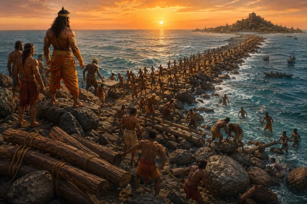
Setu differs fundamentally from Chola, Pandya, Kalinga or Matsya because it was not primarily a kingdom with a ruler, capital and political frontier. It was a geographical and sacred zone centred upon a crossing of the sea. Within the Mahabharata, its importance comes principally through the Ramopakhyana in the Vana Parva, where the story of Rama is narrated to Yudhishthira. In that account, the epic itself describes the construction of a causeway across the ocean under Nala’s direction and the movement of Rama’s army towards Lanka.
For our Mahabharata Geography reconstruction, Setu can therefore be identified broadly with the Rameswaram-Dhanushkodi maritime corridor facing Mannar in Sri Lanka. Modern Rameswaram lies on Pamban Island in Ramanathapuram district, separated from mainland Tamil Nadu by the Pamban channel. The surrounding waters form a transition between the Palk Bay-Palk Strait system to the north and the Gulf of Mannar to the south. The geography naturally creates the impression of India reaching out towards Sri Lanka through a chain of islands, shoals and shallow waters.
Setu in the Mahabharata
The strongest connection between Setu and the Mahabharata occurs in the Vana Parva. During the Pandavas’ exile, the sage Markandeya narrates the story of Rama to Yudhishthira, recounting major episodes from Rama’s exile, Sita’s abduction, the alliance with the vanaras and the campaign against Ravana. When Rama’s enormous army reaches the southern ocean, the sea itself becomes the final obstacle separating him from Lanka.
The narrative pauses over this problem because an army cannot cross the ocean in the same way that an individual hero might. Rama’s companions consider how such a vast force could be transported, and the difficulty of moving thousands of warriors across the sea becomes an important strategic question. The ocean deity ultimately reveals that Nala possesses the skill required to construct a passage, and Rama commands him to build the crossing.
The Mahabharata describes Nala’s bridge as being created from materials such as wood, grass and stone. In the epic imagination, the structure becomes the great solution to the geographical barrier posed by the sea, allowing Rama’s forces to advance towards Lanka. Setu therefore enters the Mahabharata not simply as a place-name but as the dramatic point where the limits of ordinary land travel are overcome.
Nala’s Bridge Across the Ocean
The Vana Parva gives the construction of the bridge heroic dimensions. Nala organises the work while vast quantities of material are brought towards the shore. The measurements given in the epic belong to the literary scale of heroic poetry and should not be converted mechanically into modern engineering data, but the basic geographical idea is clear: a passage is created across a shallow maritime barrier between the Indian side and Lanka.
Once the crossing has been completed, Rama’s army moves across the sea. Vibhishana, who has already abandoned Ravana and joined Rama, becomes an important ally as the forces approach Lanka. The successful crossing changes the entire strategic situation, because the ocean that had previously protected Ravana’s island kingdom no longer prevents Rama from bringing his army directly to its shores.
This makes Setu one of the most significant geographical turning points in the Rama narrative preserved within the Mahabharata. It represents the transition from continental movement across Bharata to a maritime crossing into another island realm.
A Sacred Region Rather Than a Kingdom
Setu should not be treated as an independent monarchy on the same basis as Pandya or Chola. There is no reason to imagine a separate “Kingdom of Setu” with a capital and dynastic line during the epic period. The name belongs fundamentally to the crossing and the sacred geography that developed around it.
Over time, however, Setu became so important that the surrounding coastal region itself absorbed the name. The Ramanathapuram country came to be strongly associated with Sethu Nadu, and medieval rulers of the area bore the title Sethupati, meaning guardian or lord of the Setu. The sacred crossing thus became a source of political legitimacy, with later rulers presenting themselves as protectors of the holy route associated with Rama.
For the Mahabharata period, however, the most accurate interpretation is simpler. Setu was the southern maritime threshold where Bharata approached Lanka, embedded within the wider Tamil south rather than functioning as a separate large kingdom.
Rameswaram — The Island at the Edge of the Peninsula
Modern Rameswaram lies on Pamban Island, a long, low-lying island off the Ramanathapuram coast. Its landscape is very different from the lush Kaveri delta or the mountain-backed plains around Tirunelveli. Rameswaram is comparatively flat, sandy and exposed to the sea, with salt-laden winds and a horizon dominated by water.
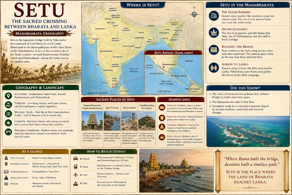
The island’s position makes it one of the most striking geographical locations in southern India. From here the Indian coastline no longer feels like an uninterrupted continental edge. Instead, land breaks into islands, shoals and shallow marine formations stretching towards Sri Lanka.
For ancient travellers who had come south through the Tamil country, reaching this region would have created a powerful sense of arriving at the limit of the mainland world. Behind them lay the kingdoms and river valleys of Bharata, while ahead lay a maritime passage and the island of Lanka.
Dhanushkodi — Where the Land Narrows Into the Sea
At the southeastern end of Pamban Island lies Dhanushkodi, one of the most dramatic landscapes associated with Setu. Here the land narrows into a long sandy extremity, and the sea becomes visible on multiple sides. The old settlement was devastated by the catastrophic cyclone of 1964, leaving ruins that still demonstrate the destructive power of the surrounding waters.
The landscape helps explain why this area became so deeply connected with the Setu tradition. Beyond the sandy shore lie shallow waters and shoals continuing towards Sri Lanka. Standing at the eastern end of Dhanushkodi, Lanka no longer seems like an abstract distant island but part of the same wider maritime horizon.
The coast here is constantly reshaped by wind, waves, currents and storms. Sandbars move, shorelines change and shallow channels alter with time. This means that the modern coastline should not be imagined as identical to that of the ancient world, but the broader geographical structure remains unmistakable.
The Chain Between India and Sri Lanka
Beyond Dhanushkodi extends the remarkable chain of shoals, reefs and shallow formations commonly known in Indian tradition as Rama Setu and in much Western geographical literature as Adam’s Bridge. These formations stretch southeastwards towards Mannar Island in Sri Lanka and create one of the most distinctive shallow marine corridors in the Indian Ocean region.
The relationship between this physical formation and the epic tradition should be presented carefully. Geological studies investigate sediments, sea-level change, coral formations and the natural evolution of the region, while the Mahabharata preserves a sacred heroic account in which Nala constructs a crossing for Rama’s army. Geological evidence by itself cannot establish every event described in epic literature, just as the existence of the epic tradition does not remove the need to understand the natural processes that shaped the coast.
What can be stated confidently is that a real chain of shallow marine features exists precisely in the geographical zone where Indian tradition has located the Setu for centuries. That correspondence helps explain why the literary memory became so powerfully anchored in this landscape.
The Sea North and South of Setu
The Setu corridor lies between two distinct marine environments. To the north stretches Palk Bay and the Palk Strait, relatively shallow waters partially enclosed by India and Sri Lanka. To the south lies the Gulf of Mannar, which contains coral-rich marine ecosystems and numerous islands along the Tamil coast.
For ancient seafarers, these waters would have been complicated rather than simply easy because of their shallowness. Sandbars could obstruct vessels, reefs could damage boats and currents could alter navigable channels. Cyclonic storms posed another serious danger and could reshape entire stretches of coast.
At the same time, the shallow character of the region would have made it visually different from an uninterrupted deep ocean. Land appears almost to continue beneath the water, with changing colours and visible shoals suggesting submerged extensions of the coastline. Such geography naturally lent itself to the powerful idea of a crossing between India and Lanka.
The Mahabharata Remembers Rama’s Crossing
The presence of the Rama story within the Mahabharata makes Setu especially interesting. Markandeya narrates Rama’s sufferings to Yudhishthira during the Pandavas’ exile in order to show that even righteous rulers had endured severe hardship before ultimately overcoming it. Rama loses his kingdom, is forced into exile, sees Sita abducted and finally confronts an obstacle that appears impossible to cross.
The southern ocean becomes one of the greatest of these obstacles. Reaching Lanka requires more than martial courage because Rama first has to transport an entire army across the sea. The building of Setu therefore represents ingenuity, determination and divine assistance combined with military necessity.
By preserving this story, the Mahabharata incorporates the geography of Rama’s southern campaign into its own conception of Bharata. The Pandavas, far away in exile, are reminded of another heroic journey that ended at the southern ocean and continued beyond it.
Vibhishana and the Southern Shore
The same narrative places Vibhishana’s decision to abandon Ravana within this southern maritime setting. Vibhishana leaves Lanka and approaches Rama with a small group of companions. Sugriva initially fears that he may be a spy, but Rama accepts him after considering his intentions.
Later sacred traditions associated particular places around Rameswaram and Dhanushkodi with Vibhishana’s surrender. The Kothandaramaswamy Temple near Dhanushkodi is traditionally identified with this episode. That exact localisation belongs to later religious geography rather than to coordinates supplied by the Mahabharata, but it demonstrates how the coastline gradually became mapped through episodes of the Rama narrative.
The result was a landscape in which beaches, sandbanks, shrines and water bodies acquired specific sacred associations. Setu was no longer remembered only as a bridge but as an entire region through which Rama’s final southern campaign unfolded.
Rameswaram and the Later Sacred Geography of Rama
The most famous sacred centre in the region today is Ramanathaswamy Temple at Rameswaram. Later Hindu tradition associates the shrine with Rama’s worship of Shiva, and Rameswaram eventually became one of India’s most important pilgrimage destinations.
A chronological distinction is necessary here. The Mahabharata clearly preserves the story of Rama’s bridge and crossing, but it does not describe the later monumental temple complex visible today. Rameswaram’s immense religious importance developed gradually through Puranic traditions, Tamil devotional culture and medieval royal patronage.
This later development does not weaken Setu’s epic identity. Instead, it shows how a geographical memory already present in the Mahabharata expanded over centuries into an elaborate sacred landscape containing temples, pilgrimage routes and ritual bathing places.
Setu as a Tirtha and Place of Crossing
The concept of Setu eventually acquired a deep religious meaning because a physical crossing could also represent a spiritual crossing. In Sanskrit religious vocabulary, a tirtha is literally a ford or place of passage and came to signify a sacred location through which human beings symbolically move from ordinary existence towards the divine.
Setu fits this idea exceptionally well. It was remembered physically as the passage by which Rama’s army crossed towards Lanka, while later religious tradition transformed the same region into a pilgrimage landscape through which devotees sought spiritual merit.
Pilgrims travelled enormous distances to reach Rameswaram, bathe in sacred waters and worship at sites associated with Rama. Thus the geographical crossing gradually became a sacred crossing as well, linking landscape, mythology and religious practice.
Gandhamadana and the View Across Rameswaram
Within the otherwise low landscape of Rameswaram, Gandhamadana Parvatham forms one of the island’s notable elevated points. Later tradition connects the place strongly with Rama, and its modest height gives it unusual importance because even a small elevation provides commanding views across a flat island.
Such natural landmarks were extremely valuable before modern maps and navigation systems. Hills, headlands, river mouths and distinctive rock formations helped travellers orient themselves across unfamiliar terrain.
In the sacred geography of Rameswaram, Gandhamadana became another example of how natural topography absorbed epic memory. The island was no longer merely a strip of sand surrounded by water but a landscape filled with places connected to Rama’s journey.
The Sacred Sea Around Rameswaram
Rameswaram’s sacred geography differs from many inland pilgrimage centres because the sea itself becomes the principal sacred water. Pilgrims traditionally bathe at Agni Tirtham and other coastal locations before worshipping at the temple.
This creates a striking contrast with the river-dominated sacred geography found elsewhere in India. At Kashi, the Ganga dominates religious life, while at Prayaga great rivers meet. At Setu, pilgrims encounter the ocean at the end of the land.
For travellers who had journeyed across the subcontinent, immersion in the waters at Rameswaram symbolically marked arrival at one of the most distant sacred edges of India. The coastline therefore became a ritual destination in its own right.
Setu and Pandya Country
Politically, the Rameswaram-Ramanathapuram region belonged to the wider historical sphere of Pandya country. Madurai and the Vaigai basin formed the principal inland heartland of Pandya power, while territories farther southeast opened towards Rameswaram and the Gulf of Mannar.
This relationship is important because Setu should not be mapped as though it were an isolated political state between Pandya and Lanka. It was fundamentally a sacred maritime zone embedded within the broader southern Tamil landscape.
Later rulers of Ramanathapuram drew prestige from their association with the crossing and used the title Sethupati. Their authority therefore demonstrates how an ancient sacred geographical memory could eventually become integrated into the political identity of the region.
Setu and the Road to Lanka
Setu’s greatest strategic significance comes from its position facing Sri Lanka across one of the narrowest maritime corridors between the island and the Indian mainland. Conventional overland travel ends at the coast, making the sea the unavoidable obstacle for anyone seeking to continue towards Lanka.
The Mahabharata’s Rama narrative is fully aware of this geographical problem. Rama’s army has already crossed enormous stretches of land, but it cannot simply continue marching once it reaches the ocean. The campaign must change fundamentally from an overland expedition into a maritime crossing.
This is what gives Setu its dramatic narrative importance. The sea protects Lanka until Rama discovers a way to overcome it, and the bridge converts geographical separation into military access.
The Coastline Was Never Permanent
The Rameswaram-Dhanushkodi region is extremely dynamic. Sandbars migrate, sediments accumulate, cyclones reshape coastlines and shallow channels change over time. The destruction of old Dhanushkodi during the cyclone of 1964 is a dramatic modern reminder of how quickly the sea can alter this landscape.
Any reconstruction of ancient Setu must therefore avoid treating today’s coastline as permanently fixed. The exact positions of beaches, sand spits and navigable channels may have differed significantly in earlier periods.
The larger geographical structure, however, remains stable enough for identification. Mainland Tamil Nadu leads towards Pamban Island, and beyond the island lies a shallow corridor stretching in the direction of Mannar and Sri Lanka. This broad pattern is the essential geographical feature behind the Setu tradition.
A Landscape of Sand, Salt and Wind
The physical character of Setu is unlike the agricultural abundance of the Kaveri delta or the river valleys around Madurai and Tirunelveli. Much of the region is low, sandy and exposed to maritime conditions. Salt-tolerant vegetation grows across dunes and coastal flats, while fishing communities have adapted their lives to the surrounding sea.
Freshwater is more precious here than in river-fed agricultural regions. Wind and salt shape vegetation, while currents continually reshape sandbanks and beaches. During calm periods, the sea can appear almost motionless, with pale turquoise water stretching across the shallows. During cyclonic storms, the same sea becomes violently destructive.
This mixture of fragility and grandeur gives Setu much of its distinctive character. It is a landscape in which the boundary between land and water seems temporary and constantly changing.
Marine Wealth of the Gulf of Mannar
South of the Setu corridor lies the Gulf of Mannar, one of the great marine ecological zones of southern India. Coral environments, islands and shallow waters support diverse marine life, while the wider southern Tamil coast became historically famous for fishing, conch gathering and pearl diving.
These resources connected Setu with the broader economy of Pandya country. Farther southwest lay the celebrated pearl fisheries associated with Korkai and the Tamiraparani coast.
The Mahabharata does not provide an economic survey of Setu, and later documented pearl and maritime industries should not automatically be projected into an epic date. Nevertheless, the ecological foundation of this maritime economy belongs to the natural geography of the region.
The sea therefore functioned not merely as a barrier. It was also a source of food, wealth and communication.
The Southern Sacred Frontier of Bharata
As Rameswaram grew in religious importance, Setu became one of the great sacred frontiers of India. Pilgrims travelling south eventually reached a point where the subcontinent narrowed into islands, shoals and sea.
Northward lay the enormous geographical sweep of Bharata, while southward lay Lanka. Between them stood the sacred memory of Rama’s crossing.
This geographical symbolism contributed greatly to the later religious importance of Rameswaram. The region came to represent one of the southernmost sacred limits of India, completing pilgrimage networks that connected distant parts of the subcontinent.
Setu thus became a place where geography itself carried theological meaning.
What the Mahabharata Actually Preserves
Because Setu accumulated many later traditions, it is important to separate the core epic evidence from later religious elaboration. The Mahabharata’s Ramopakhyana clearly preserves the story of Rama reaching the southern ocean, learning that Nala could construct the passage, building the bridge and taking his army across towards Lanka.
The epic does not, however, give a modern geographical coordinate for the beginning of the bridge. It also does not describe the monumental Ramanathaswamy Temple or the full network of sacred places known from later Rameswaram tradition.
The strongest reconstruction therefore combines two layers carefully. The first is the epic memory of a crossing between the Indian side and Lanka. The second is the long-standing later localisation of that crossing around Rameswaram, Dhanushkodi and the shallow chain extending towards Mannar.
Keeping these layers distinct preserves both historical caution and the richness of the tradition.
Setu in the Epic Landscape
To visualise Setu in the epic world, imagine an enormous army reaching the final edge of the land after a long southern journey. Behind the warriors lie forests, mountains, rivers and kingdoms already crossed. Ahead stretches the ocean, and beyond it lies Lanka.
The army establishes itself along the shore while leaders consider how such a force can continue. The sound of the sea replaces the noise of marching columns, and the salt wind moves across the camp while thousands of warriors wait for a solution.
Construction eventually begins under Nala’s direction. Timber, stone and other materials are brought forward, and the epic imagines a passage taking form across the water. What had been an impassable barrier becomes a road.
The army then begins moving across the sea towards Lanka, transforming the strategic situation completely.
From Setu to Lanka
Once the crossing is complete, Rama’s campaign enters its final phase. His forces reach Lanka, occupy the approaches to the city and prepare for battle. Ravana’s island kingdom, previously protected by the surrounding sea, now faces an invading army that has crossed the maritime barrier.
Setu therefore functions as the logistical hinge of the entire campaign. Without it, Rama’s army remains stranded on the Indian side. With it, the war can be carried directly into Lanka.
This makes the crossing simultaneously a geographical feature, an engineering marvel within epic tradition and one of the decisive strategic moments of the Rama narrative preserved in the Mahabharata.
Finding Setu Today
A modern journey through the Setu landscape begins along the Ramanathapuram coast and continues towards Pamban Island. After crossing the Pamban channel, the traveller enters Rameswaram, where sacred sites and marine geography dominate the island.
Continuing southeast eventually leads towards Dhanushkodi, where the land becomes increasingly narrow and sandy. The remains of the cyclone-destroyed town stand amid a landscape shaped almost entirely by wind and sea.
Beyond the visible shore lies the shallow maritime corridor extending towards Sri Lanka. Even without accepting every later localisation literally, the physical geography makes clear why this place became attached so strongly to the memory of Rama’s crossing.
Setu — Where Bharata Reached Across the Sea
Setu occupies a unique place in Mahabharata geography because it was not a kingdom but a threshold between land and ocean. The Vana Parva’s Ramopakhyana remembers Rama reaching the southern sea, confronting the problem of transporting his army to Lanka and constructing a crossing under Nala’s direction.
Later tradition anchored this epic memory around Rameswaram and Dhanushkodi, transforming the region into one of India’s greatest sacred landscapes. Modern geography helps explain why the identification endured, because Pamban Island projects towards Sri Lanka while a remarkable sequence of shallow shoals and sandbanks continues in the direction of Mannar.
For our Mahabharata Geography reconstruction, Setu should therefore be placed around Rameswaram, Dhanushkodi and the southeastern Ramanathapuram coast facing Sri Lanka, with the maritime corridor extending conceptually towards Mannar. It should be presented not as a large independent kingdom but as a sacred geographical region within the broader Pandya south.
Its landscape was shaped by shallow seas, sandbars, islands, marine channels and the narrow approach towards Lanka. Its epic identity arose from one of the most celebrated crossings in Indian literary tradition, while its later religious importance transformed it into a pilgrimage destination known throughout the subcontinent.
Setu therefore represents something more than a line between two shores. It is the place where the Mahabharata’s geographical imagination reaches the edge of India and then continues beyond it, carrying Rama’s army across the sea towards Lanka.
You may also like
-
One Voice – One Resolve – One India: Namami Bharatam Marks 150 Years of Vande Mataram Across the Nation
-
Dravida — The Ancient Tamil Country of Rivers, Temples and the Southern Ocean
-
Pandya — The Southern Kingdom of the Vaigai, Tamiraparani and the Pearl-Rich Sea
-
Chola — The Kaveri Kingdom of Fertile Fields, Ancient Cities and the Eastern Sea
-
Mushika — The Northern Malabar Kingdom Beneath Ezhimala and Beside the Arabian Sea
