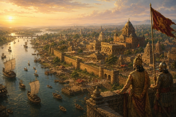
Mahabharata Geography — Gauda
Modern geographical correspondence: Western and northwestern Bengal, centred broadly on the Murshidabad–Birbhum–Bardhaman–Malda corridor, with the wider historical Gauda landscape extending across parts of present-day West Bengal in India and adjoining Bangladesh
Present countries: India and Bangladesh
Across the western side of Bengal, where the Ganges and Bhagirathi open the great eastern plains towards the delta, emerged a geographical name that would eventually become one of the most powerful political identities in the history of the region. Gauda, or Gauḍa, began as the name of a particular country in western Bengal, rose under rulers such as Shashanka, expanded with the power of the Pala and Sena kingdoms, and in later centuries could even be used as a wider designation for Bengal itself.
The landscape historically associated with Gauda extended through some of the most strategically important country in eastern India. The Bhagirathi-Ganges corridor linked the lower Gangetic plains with northern Bengal and the delta, while the slightly higher lands of western Bengal provided routes towards Magadha, Rarh and the mineral-rich uplands farther west. Fertile riverine plains supported agriculture, and changing river channels repeatedly created, enriched and sometimes destroyed political centres.
Gauda requires greater chronological caution than neighbouring Pundra or Vanga when it is viewed through the Mahabharata. The standard epic clearly and repeatedly names Pundra, Vanga, Suhma, Anga, Tamralipta and other eastern peoples, but Bengal’s Gauda does not appear with the same secure and explicit status as a Mahabharata kingdom. The geographical name becomes much more firmly documented in historical sources of the early centuries CE and especially from the sixth and seventh centuries onwards.
This distinction does not make Gauda unimportant to ancient Bengal. On the contrary, it reveals how the political vocabulary of the eastern subcontinent changed over time. The landscape that the Mahabharata divided among Pundra, Vanga, Suhma and related eastern regions would later witness the emergence of Gauda as one of Bengal’s dominant geographical and royal identities.
Gauda and the Mahabharata — An Important Chronological Distinction
The Mahabharata possesses an extraordinarily detailed knowledge of eastern India. Bhima’s eastern campaign moves through Videha, Magadha, Pundra, Vanga, Suhma and coastal territories, while the Kurukshetra narratives repeatedly mention warriors from Anga, Vanga, Pundra, Kalinga and Tamralipta. The epic also preserves the legendary genealogy in which Anga, Vanga, Kalinga, Pundra and Suhma become the names of five great eastern countries.
Gauda is different. Historical scholars have long noted that Gauda as the recognised Bengal country is not securely listed among these principal Mahabharata eastern kingdoms. An older historical study of eastern India explicitly observed that the Bengal Gauda name does not occur in the Mahabharata, while modern historical geography places its clearer emergence in later literature and epigraphy.
This point prevents a common chronological mistake. It would be inaccurate to invent a Gauda king fighting Bhima or to place a named Gauda contingent at Kurukshetra when the relevant epic passages actually speak of Pundras, Vangas, Suhmas and other peoples.
The geographical importance of Gauda instead lies in what happened after the world represented by those epic names. A portion of western Bengal acquired a new and increasingly powerful identity, and Gauda eventually became important enough to overshadow several older regional names.
The Eastern Bengal World Before Gauda’s Rise
The Bengal remembered by the Mahabharata was not a single kingdom. It was a mosaic of countries formed by river systems, coastal environments, forest margins and older tribal identities.
Pundra occupied the northern Bengal world centred historically around the Karatoya and Pundranagara. Vanga belonged principally to the central, southern and eastern delta. Suhma represented a western or southwestern Bengal country, while Tamralipta stood as an important coastal and riverine centre. Farther west, Anga connected Bengal with the lower Gangetic country of eastern Bihar.
These names reveal that the geography underlying later Bengal was already politically complex. Gauda subsequently arose within this same larger eastern environment, but it did not simply replace every earlier name at once.
Even centuries later, geographical texts continued to distinguish Gauda from neighbouring regions. Banglapedia notes that Varahamihira’s Brihat Samhita separately names Gaudaka, Pundra, Vanga, Samatata, Vardhamana and Tamralipta, showing that Gauda originally represented one particular part of Bengal rather than the entire eastern country.
The Earliest Historical Gauda
The geographical name becomes much clearer outside the epic. Banglapedia records that the Arthashastra refers to Gauda alongside Vanga, Pundra and Kamarupa, although the precise boundaries of the territory are not described. Later authors, including Vatsyayana and Varahamihira, also knew Gauda as an eastern country.
The most secure early evidence comes from inscriptions. The Haraha inscription of the Maukhari ruler Ishanavarman, dated to around 554 CE, refers to the Gaudas and is regarded as the earliest epigraphic evidence for the people or territory. The inscription describes Ishanavarman as defeating Gaudas associated with a maritime or watery environment.
By the sixth century, therefore, Gauda had become sufficiently established to appear in political records beyond Bengal itself. Within another century, the name would become attached to one of the most powerful kings eastern India had produced.
Where Was Ancient Gauda?
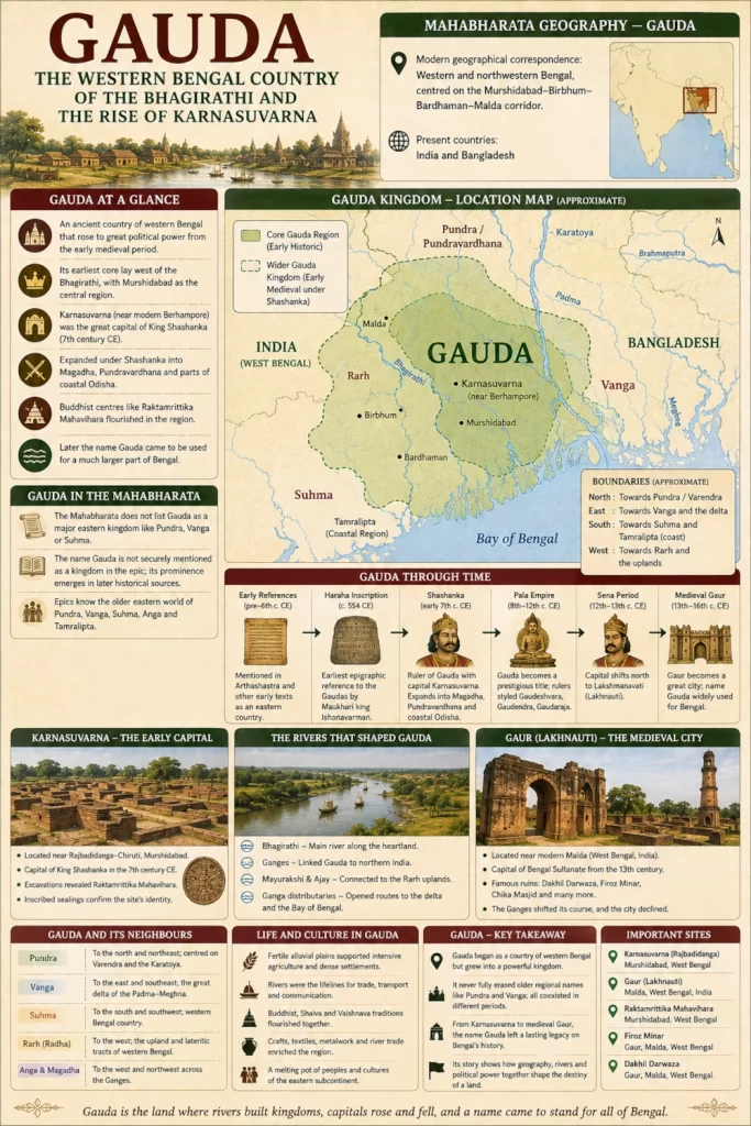
The earliest Gauda was centred primarily in western Bengal, not in the eastern delta. Banglapedia concludes that its original core lay west of the Bhagirathi, with Murshidabad forming the central region. The geographical reconstruction from early literary sources also brings parts of Birbhum and western Bardhaman into the broader Gauda country.
This creates an approximate ancient landscape extending from the Bhagirathi river country westwards into the transitional plains approaching Rarh. To the north lay Pundra and the Varendra country, while Vanga occupied the delta farther east and southeast.
The name later expanded enormously, which explains why different texts appear to give Gauda different boundaries. A geographical name attached to a successful kingdom can spread far beyond the small territory where it originally arose.
Gauda is therefore best understood in layers. Its early geographical core was western Bengal, its seventh-century political kingdom became much larger, and its medieval meaning could include most or even all of Bengal.
The Bhagirathi — River Along the Gauda Heartland
Few geographical features are more important to the history of Gauda than the Bhagirathi, one of the great distributary channels of the Ganges system. The river helped divide and connect Bengal at the same time, creating an important axis between the upper delta and the northern Gangetic routes.
The earliest core of Gauda appears to have occupied country on or west of this river system. To the east, the landscape gradually opened towards the more intensely riverine Vanga and deltaic regions, while the western side approached the older soils and uplands of Rarh.
River transport would have been essential. Grain, textiles, timber, soldiers, officials and merchants could move through the waterways far more efficiently than through many stretches of monsoon-soaked countryside.
Political centres situated near the Bhagirathi could therefore control movement between northern Bengal, the lower Ganga and the delta. That strategic advantage became particularly visible with the rise of Karnasuvarna.
Karnasuvarna — The Great Capital of Gauda
The first historically powerful kingdom firmly associated with Gauda centred on Karnasuvarna, near modern Berhampore in Murshidabad district of West Bengal. It became famous as the capital of Shashanka, the seventh-century ruler who transformed Gauda into a major political power.
Karnasuvarna has been located with unusual archaeological confidence. The site lies around Rajbadidanga and the Chiruti area of Murshidabad, where excavations revealed the remains of the Raktamrittika Mahavihara. Inscribed sealings carrying the monastery’s name helped confirm the identification recorded in the itinerary of the Chinese pilgrim Xuanzang.
This gives historical Gauda something the epic kingdoms do not always possess: an archaeologically identifiable capital from a securely documented later period.
Karnasuvarna should nevertheless not be projected backwards into the Mahabharata. Its archaeological and textual prominence belongs principally to the early medieval period, roughly a millennium or more after many traditional chronologies assigned to the events of the epic.
A Wealthy Country of Farms and Settlements
Xuanzang’s account of Karnasuvarna, preserved through later translations and historical studies, depicts a prosperous region. The country was described as well populated, agriculturally productive and rich, with low and moist land, abundant flowers and fruits and a population that supported learning.
The description fits the geography of the middle and lower Gangetic plains. Seasonal river flooding and fine alluvial soils supported intensive agriculture, while waterways created communication routes among settlements.
Such conditions could sustain a large capital, monasteries, military establishments and royal administration. Gauda’s later political strength cannot be separated from this productive agricultural base.
The country was not, however, uniformly wet delta. Western Bengal gradually rises away from the youngest alluvial plains, producing a transition from riverine country to the older lateritic and reddish soils associated with Rarh.
Rarh and Gauda — Neighbours Within Western Bengal
Rarh, or Radha, represents one of the oldest regional identities of western Bengal. Historical traditions generally associate it with country farther west and southwest, including substantial parts of modern Birbhum, Bardhaman and neighbouring districts.
The relationship between Rarh and Gauda changed over time. Some sources distinguish the two clearly, while later political usage could bring parts of Rarh inside a wider Gauda kingdom. Banglapedia notes that certain medieval traditions included Rarh within Gauda, while other inscriptions continued to treat them as separate geographical entities.
This apparent contradiction is exactly what should be expected from changing political geography. When Gauda was simply a regional country, Rarh could remain beside it. When kings ruling from Gauda expanded their power, the political meaning of Gauda could absorb neighbouring regions.
The boundary was therefore historical rather than permanent.
Gauda and Pundra
To the north and northeast lay Pundra or Pundravardhana, the older northern Bengal country centred historically on the Karatoya and Pundranagara at Mahasthangarh.
The two identities remained distinct in several geographical traditions. Varahamihira, for example, listed Gauda and Pundra separately. Yet political expansion could place both under one ruler.
During the reign of Shashanka, the power of Gauda appears to have extended into Pundravardhana. Banglapedia notes evidence connecting his kingdom with northern Bengal and conflicts involving the neighbouring kingdom of Kamarupa.
The political kingdom of Gauda therefore eventually reached well beyond its original western Bengal core. This later expansion helps explain why some historical traditions use Gauda for territory much farther north than the region where the name probably began.
Gauda and Vanga
Vanga lay principally to the east and southeast of early Gauda. It belonged to the great deltaic world created by the Ganges, Padma, Meghna and their distributaries.
The distinction between Vanga and Gauda survived for centuries. Early medieval history repeatedly shows eastern or southeastern Bengal developing separately from the kingdoms controlling western and northern Bengal. Banglapedia notes that Vanga and Gauda remained recognisable political identities even when powerful rulers periodically attempted to unite them.
Later, however, the extraordinary political prestige of Gauda caused the name to widen. Pala and Sena rulers could be called lords of Gauda while exercising power across much larger parts of Bengal.
Eventually Gauda and Vanga could both function as broad names connected with Bengal, even though their earlier geographical cores had been very different.
Gauda and Suhma
The relationship with Suhma is even more important for understanding the transition between epic and later geography. Suhma belongs securely to the eastern world of the Mahabharata and is generally placed within western or southwestern Bengal.
Later Gauda expanded across part of this same broader western Bengal landscape. This means that some territory that might be described through an epic geographical vocabulary as Suhma or neighbouring western Bengal could appear in early medieval sources under the political dominance of Gauda.
The two should therefore not be treated as synonyms across all periods. One belongs securely to the epic’s own geographical terminology, while the other became increasingly important in later centuries.
This layered naming is common throughout Indian historical geography. Kingdoms disappear, regional identities survive, and powerful new capitals sometimes lend their names to territories much larger than those originally associated with them.
Shashanka — The King Who Made Gauda a Major Power
Gauda’s greatest early transformation came under Shashanka, who ruled in the early seventh century CE. Literary and epigraphic sources identify him as a ruler of Gauda, with Karnasuvarna as his capital.
Shashanka expanded far beyond western Bengal. His political influence included Magadha, extended north towards Pundravardhana and reached south into parts of coastal Odisha. For a time, Gauda became one of the major powers competing for control of northern and eastern India.
This expansion fundamentally altered the meaning of the name. Gauda was no longer merely a country near the Bhagirathi; it was the centre of a kingdom whose ruler controlled extensive territory.
Political prestige often transforms geography. Just as the names Magadha, Kuru or Kosala could carry influence beyond their original centres during periods of expansion, Gauda began to acquire a wider significance because of the power of the kingdom associated with it.
Conflict With Kamarupa and North India
Shashanka’s rise placed Gauda within the larger political contest involving Harshavardhana of Kanauj and Bhaskaravarman of Kamarupa. Northern Bengal formed an important frontier between Gauda and Kamarupa, while Magadha connected Shashanka’s kingdom with the central Gangetic world.
The conflict illustrates Gauda’s strategic position. A power based in western Bengal could move westwards into Bihar, northwards towards Pundra and the Brahmaputra approaches, or southwards towards Odisha.
The same basic geography had connected eastern kingdoms to the wider world even in the Mahabharata. Bhima’s campaigns and the movement of eastern armies towards Kurukshetra followed the great corridors of the Ganga plain.
Gauda later occupied one of the most important intersections within that network.
The Buddhist Landscape Around Karnasuvarna
The archaeological landscape surrounding Karnasuvarna also reveals the religious complexity of Gauda. The remains at Raktamrittika Mahavihara demonstrate that a major Buddhist institution flourished near the political capital.
Excavations produced structural remains, seals, sealings and other objects associated with the monastery. One of the important finds was an inscribed sealing that confirmed the name Raktamrittika Mahavihara, helping scholars connect the archaeological site with the monastery mentioned in Xuanzang’s itinerary.
Gauda was therefore not simply a political kingdom. Its capital region supported religious establishments connected with wider intellectual and pilgrimage networks stretching across the subcontinent and beyond.
A sailor named Buddhagupta associated with Raktamrittika even appears in an inscription found in the Malay Peninsula, suggesting contacts linking Bengal’s religious and mercantile communities with the maritime world of Southeast Asia.
Rivers Connected Gauda to the Sea
Although the earliest heart of Gauda lay inland along the western Bengal river system, inscriptions and historical descriptions also associate the Gaudas at times with maritime or coastal environments.
The Haraha inscription describes the Gaudas in language connected with the sea, while later epigraphic material similarly refers to a ruler of Gauda occupying a watery stronghold. Banglapedia interprets these references as evidence that the Gauda political sphere at certain periods extended into coastal Bengal.
Shashanka’s expansion provides a plausible historical context for this broader geography. His kingdom stretched southward into coastal territories, while the navigable river network linked Karnasuvarna and western Bengal with the Bay of Bengal.
Gauda therefore possessed access to both the inland Gangetic world and maritime Bengal.
From Regional Kingdom to Name for a Much Larger Realm
The centuries after Shashanka saw further expansion in the meaning of Gauda. Under the Pala rulers, inscriptions from outside Bengal frequently used titles such as Gaudeshvara, Gaudendra and Gaudaraja for Bengal’s kings.
By this time, Gauda could refer politically to territory far beyond the original Murshidabad-centred country. A ruler controlling Bengal, Bihar and parts of northern India might still be identified as the lord of Gauda because the name had acquired royal prestige.
The same process continued under later dynasties. The Senas also used titles connecting themselves with Gauda, and medieval Sanskrit traditions increasingly treated Gauda as one of the great regional identities of eastern India.
The transformation resembles the history of several famous ancient names. A relatively limited geographical country becomes the homeland of an important dynasty, and the dynasty’s success causes the regional name to spread.
The Palas and the Prestige of Gauda
The Pala Empire, founded in Bengal during the eighth century, became one of the largest political powers in early medieval India. At different moments its rulers controlled Bengal, Bihar and extensive portions of the Gangetic plains.
Although the Pala political heartland incorporated several older Bengal regions, rival inscriptions often described its rulers as kings or lords of Gauda. This indicates that Gauda had become a powerful political shorthand for Bengal’s imperial authority.
The Palas also deepened Bengal’s role within the Buddhist world. Great monastic universities and religious centres flourished under their patronage, while artistic and intellectual connections extended into Nepal, Tibet and Southeast Asia.
The geographical name Gauda was consequently carried far beyond western Bengal by diplomacy, conquest and religious networks.
The Sena Period and Lakshmanavati
The political centre of Bengal later shifted northwards towards the Malda-Ganges region. During the Sena period, Lakshmanavati, associated with King Lakshmanasena, emerged as an important royal centre.
Under later Muslim rule, Lakshmanavati became known as Lakhnauti. Banglapedia places the ruined city within modern Malda district and describes its relationship with the changing channels of the Ganges and Mahananda.
This shift is important because the word Gaur or Gauda eventually became closely associated with the famous ruined city near modern Malda.
The medieval city should not be confused with the original western Bengal Gauda janapada centred farther south around Murshidabad. The same name had by then undergone centuries of political expansion and geographical change.
Gaur — The Great Medieval City
The ruins commonly called Gaur lie south of modern Malda, close to the present international boundary between India and Bangladesh. The city became one of the largest political centres in medieval Bengal and served as the capital of powerful Sultanate dynasties.
Banglapedia describes Gaur as an immense urban settlement occupying the land between the Ganges and Mahananda systems, while West Bengal Tourism identifies Gaur as one of the major historical sites accessible from Malda.
The archaeological landscape contains gateways, mosques, towers, tombs and other structures belonging primarily to the medieval Sultanate and Mughal periods. The Archaeological Survey of India lists numerous protected monuments at Gaur, including the Dakhil Darwaza, Firoz Minar, Chika Masjid, Tantipara Mosque and several gateways and tombs.
None of these monuments belongs to the Mahabharata world or to the earliest Gauda janapada. Their importance lies in showing how remarkably long the Gauda-Gaur name survived as a symbol of political power in Bengal.
The Ganges Changed the Fate of Gaur
The history of Gaur demonstrates one of the defining characteristics of Bengal: rivers can create capitals and later abandon them.
The Ganges once flowed much closer to the city. As its channels shifted, the relationship between Gaur, Lakhnauti and the surrounding river routes changed substantially. Banglapedia notes that alterations in the Ganges system were important in the transformation of the urban landscape.
A capital dependent upon riverborne communication could prosper while a major channel flowed nearby. If that river moved kilometres away, ports declined, water supplies changed and political geography could shift with it.
This instability is central to understanding Bengal through every period. Kingdom boundaries were not merely altered by conquest; the physical geography itself could move.
Gauda Across the Modern India-Bangladesh Border
The modern international border divides landscapes that historically belonged to continuous river and settlement systems. Most of the medieval ruins of Gaur lie within Malda district of West Bengal, but the wider historical urban and territorial landscape reaches towards Chapainawabganj in Bangladesh.
The earliest core of Gauda around Murshidabad lies firmly inside present-day India. Later Gauda, however, expanded across large parts of Bengal, and the medieval political meaning of the name extended well beyond any modern boundary.
It is therefore historically appropriate to describe Gauda as a region associated today with India and Bangladesh, while recognising that its most securely reconstructed early core lay in western Bengal.
Modern borders belong to the twentieth century. Gauda belongs to a much older geographical world shaped by rivers, dynasties and shifting centres of settlement.
Malda, Murshidabad and Two Different Gauda Landscapes
Two modern districts are particularly important for understanding the name.
Murshidabad represents the heartland of the early historical Gauda kingdom, especially through Karnasuvarna and Shashanka. Archaeological evidence around Rajbadidanga places the seventh-century capital firmly within this region.
Malda, farther north, preserves the great medieval Gaur-Lakhnauti landscape. Its surviving monuments belong many centuries later, but the city’s fame eventually became so great that Gaur itself became one of the best-known historical names of Bengal.
The distinction is essential. Karnasuvarna and medieval Gaur are not the same capital separated only by different names. They represent different phases in the long political history of Gauda.
Together they demonstrate how the centre of gravity of Bengal moved along its river systems across the centuries.
Why Western Bengal Could Support a Powerful Kingdom
The western Bengal position offered several strategic advantages. The region stood close enough to the Ganges to participate fully in the commercial and political networks of the Gangetic plain, while also controlling approaches into the Bengal delta.
To the west lay routes towards Magadha and the mineral-bearing uplands of Jharkhand and Rarh. To the north were Pundra, Varendra and the corridors leading towards Kamarupa. To the south stretched the routes towards Tamralipta and coastal Odisha.
Agriculture supported large populations, while rivers provided transport for goods that would have been difficult to move in bulk overland.
A strong ruler established in this zone could therefore project power in several directions. Shashanka’s kingdom demonstrated precisely this geographical possibility.
Gauda’s Place in the Cultural History of Bengal
The name Gauda eventually moved beyond political geography. Forms such as Gaudiya became cultural descriptors associated with Bengal, and the regional name survived in literary, religious and social traditions long after the original kingdom disappeared.
This wider use reflects Gauda’s historical prestige. Once the name had become associated with major dynasties and royal capitals, it could stand for much more than one district.
By the medieval period, rulers of Bengal could be described as lords of Gauda even when their authority extended across territories that earlier generations would have called Pundra, Vanga, Rarh or Samatata.
The process helped prepare the way for later concepts of Bengal as a more unified geographical and political region.
Gauda Did Not Replace Bengal’s Older Identities Completely
Despite its growing prestige, Gauda never erased the older geographical vocabulary immediately. Vanga, Varendra, Rarh and other regional names continued to appear, sometimes within the same historical periods in which kings carried Gauda titles.
This coexistence demonstrates that pre-modern geography operated on several levels simultaneously. A person could belong to a local district, a historical region and a larger kingdom without those identities contradicting one another.
Gauda might therefore describe the ruling kingdom while Varendra still described northern Bengal or Rarh described the western interior.
Modern expectations of one official geographical name covering one permanent administrative territory do not fit such a landscape.
Gauda and the Memory of Ancient Bengal
Gauda’s absence as a clearly defined Bengal kingdom from the main Mahabharata geographical passages is itself historically informative. It suggests that the political vocabulary preserved by the epic represents an older layer in which Pundra, Vanga, Suhma and Anga were the dominant eastern names.
Later centuries reorganised that landscape.
Gauda emerged, Karnasuvarna rose, Shashanka expanded, the Palas built an empire and the Senas inherited the prestige of the region. Eventually a great city called Gaur dominated the lower Ganges country and the name became famous far outside Bengal.
The transformation from the epic geography of Pundra-Vanga-Suhma to the historical geography of Gauda shows how Indian regional identities evolved rather than remaining frozen from one age to another.
A Note on the Word “Gauda” in the Karna Parva
Some English translations of the Mahabharata contain the word Gauda, but one such occurrence can be misleading. In the Karna Parva, during Karna’s hostile description of the people of the Punjab, the text refers to a drink translated as “Gauda liquor.” This is a beverage and not a reference to the Bengal kingdom of Gauda.
The distinction matters because a search for the word alone can create the false impression that the epic explicitly names Gauda as an eastern country in that passage.
Geographical identification must depend upon the meaning and context of the Sanskrit term, not simply the appearance of the same spelling in an English translation.
The Historical Landscape Today
Travelling through the old Gauda country today reveals several layers of Bengal’s history superimposed upon one another.
Around Karnasuvarna in Murshidabad, the traveller encounters archaeological traces of the seventh-century capital and the Raktamrittika monastic complex. The landscape remains intensely agricultural and riverine, preserving something of the environmental character described in early historical accounts.
Farther north in Malda, the ruins of medieval Gaur form an entirely different historical landscape. Massive gateways, mosque ruins, towers and scattered masonry speak of the Bengal Sultanate rather than Shashanka’s kingdom.
Between these two centres flows a geographical history measured not only in dynasties but in shifting rivers.
The Gauda Country Before the Medieval Cities
To imagine the older western Bengal landscape, the monumental ruins of Sultanate Gaur must disappear. The enormous later gateways and mosques belong to a world far removed from the earliest Gauda janapada.
What remains is a country of Ganges and Bhagirathi channels, fertile plains, wetlands, forest margins and the gradual transition into the drier western uplands.
Villages stand upon slightly raised ground beside tanks and streams. Agricultural fields extend across the river plains, while boats carry grain and travellers between settlements.
Farther west, the country becomes less dominated by the youngest alluvium and increasingly resembles the older Rarh landscape.
This was the geographical foundation from which Gauda emerged.
From the Epic East to Historical Gauda
During the geographical world preserved by the Mahabharata, the east was represented most clearly through countries such as Pundra, Vanga, Suhma and Anga. Armies and rulers from those regions interacted with the Pandavas, attended the Rajasuya and marched to Kurukshetra.
Centuries later, western Bengal acquired a political identity whose name would become equally famous.
Gauda’s rise therefore represents continuity of landscape but change of political vocabulary.
The same rivers continued flowing through Bengal, though their channels changed. The same broad corridors connected Magadha with the east. Agricultural settlements continued to expand, while new capitals emerged in places that earlier texts had known under different regional names.
History did not replace geography. It repeatedly renamed it.
Gauda — The Kingdom That Gave Its Name to Bengal
Gauda occupies a distinctive place in the geographical history of eastern India because its importance grew enormously after the epic age. Its earliest securely reconstructed heartland lay in western Bengal, particularly the Murshidabad region west of the Bhagirathi, with parts of Birbhum and Bardhaman forming part of the wider country.
Under Shashanka in the seventh century, Gauda became a major kingdom centred at Karnasuvarna, extending north towards Pundravardhana, west into Magadha and south towards Odisha. Later Pala and Sena power expanded the prestige of the name still further until Gauda could sometimes represent Bengal or a much larger eastern empire.
The geographical centre subsequently shifted towards Lakshmanavati-Lakhnauti and Gaur in the Malda region, where the name survived through one of medieval Bengal’s greatest cities. The ruins of that later capital remain visible today, divided from parts of their historical hinterland by the modern India-Bangladesh frontier.
Gauda should therefore be understood as a historical successor within the ancient Bengal landscape rather than a kingdom that can simply be inserted unchanged into every Mahabharata episode. The epic preserves the older eastern world of Pundra, Vanga and Suhma; later history reveals how Gauda rose among those same river plains and ultimately became one of Bengal’s most influential geographical names.
From the Bhagirathi country of Murshidabad to the great ruins of Gaur near Malda, the name travelled northward and expanded across centuries of conquest, administration and cultural change. Rivers moved, capitals shifted and kingdoms disappeared, yet Gauda endured in the historical memory of Bengal.
Gauda was the western Bengal country that grew from a regional janapada into the heart of powerful kingdoms—a land of the Bhagirathi and Ganges whose name eventually came to represent far more than the territory from which it began.
You may also like
-
Pundra — The Northern Bengal Kingdom of the Karatoya and the Ancient City of Pundranagara
-
Vanga — The River Kingdom of the Bengal Delta and the Eastern Sea
-
Kishkindha — The Boulder Kingdom of Pampa, Rishyamukha and the Tungabhadra
-
Setu — The Sacred Southern Crossing Between Rameswaram and Lanka
-
One Voice – One Resolve – One India: Namami Bharatam Marks 150 Years of Vande Mataram Across the Nation
