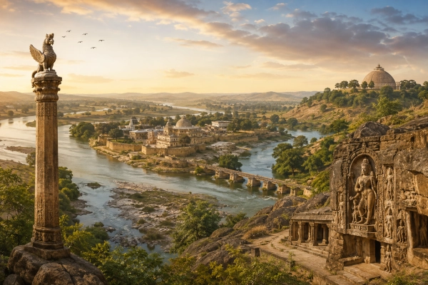
For the Mahabharata period, however, Vaidisha requires slightly more careful treatment than kingdoms such as Kuru, Panchala, Matsya or Chedi. The epic repeatedly recognises the Dasharnas, whose country is widely associated with the Vidisha and eastern Malwa region, and it also names the Vetravati, identified with the modern Betwa. The surviving Mahabharata text does not securely name Vidisha itself as a political capital. Later Sanskrit literature and the Puranas make the relationship clearer, preserving Vaidiśa as a Vindhyan country and identifying Vidisha with the political centre of the wider Dasharna landscape.
Vaidisha can therefore be understood in this series as the Vidisha-centred political and urban zone within the broader central Indian world known to the Mahabharata, while Dasharna represents the larger regional identity surrounding it.
Vaidisha at a Glance
| Feature | Description |
|---|---|
| Ancient Name | Vaidisha / Vaidiśa / Vidisha |
| Modern Identification | Vidisha and adjoining central Madhya Pradesh |
| Ancient Urban Core | Vidisha-Besnagar |
| Broader Epic Region | Dasharna and the eastern Malwa-Vindhyan country |
| Principal River | Vetravati, identified with the Betwa |
| Secondary River | Bes |
| Mahabharata Association | Dasharna country and Vetravati occur within the epic geography |
| Puranic Identity | Vaidisha listed among the countries of the Vindhyan region |
| Later Literary Association | Vidisha remembered as the chief city or capital of Dasharna |
| Major Nearby Ancient Centres | Besnagar, Udayagiri and Sanchi |
| Modern State | Madhya Pradesh |
| Country Today | India |
The Land of Vaidisha
The geographical heart of ancient Vaidisha can be placed around modern Vidisha and Besnagar, northeast of Bhopal in Madhya Pradesh. The district lies around the meeting zone of the Betwa and Bes rivers, while ancient Besnagar stood only a few kilometres from the modern city. The Government of Madhya Pradesh describes Vidisha as lying in the fork of these rivers, with Sanchi situated nearby.
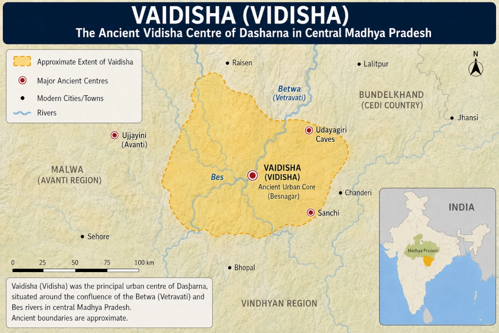
For the purpose of reconstructing Mahabharata-era geography, the core may be represented approximately as:
Vidisha-Besnagar → Betwa/Vetravati valley → eastern Malwa → adjoining Raisen and central Madhya Pradesh
The boundaries should not be drawn like those of a modern district. Ancient janapadas depended on river valleys, settlements, agricultural zones, trade routes and the authority exercised by individual rulers. Their frontiers could expand or contract over time.
Vaidisha therefore makes more sense as a Vidisha-centred cultural and political zone than as a kingdom enclosed within a sharply surveyed border.
Vidisha and Besnagar: The Ancient Urban Centre
Modern Vidisha does not occupy precisely the same settlement footprint as ancient Besnagar. The older city developed around the confluence of the Bes and Betwa rivers, a few kilometres from modern Vidisha. Archaeological and historical investigations have established Besnagar as one of central India’s important ancient settlements.
This location was exceptionally favourable.
The Betwa valley opened routes northeastward toward Bundelkhand and eventually the Yamuna. Westward lay the Malwa plateau and Ujjain. Southward, routes approached the Vindhyan and Narmada regions, while the northern approaches connected the area with the great political centres of the Ganga-Yamuna world.
Vidisha was therefore not an isolated inland town. Its geography placed it at a crossroads between several of the regions that repeatedly appear in the Mahabharata.
Vaidisha and Dasharna: Understanding the Difference
Vaidisha and Dasharna should not simply be treated as two completely unrelated kingdoms occupying the same territory.
The more useful geographical interpretation is that Dasharna represented the broader country, while Vidisha or Vaidisha developed as one of its principal urban and political centres.
The Mahabharata explicitly mentions the Dasharnas at several points. Its great geographical description of Bharatavarsha in the Bhishma Parva includes the Dasharnas among the peoples of the land. The epic also preserves rulers and warriors identified with Dasharna.
Vidisha itself becomes much more clearly associated with Dasharna in later Sanskrit literature. Kalidasa’s Meghaduta treats Vidisha as the great city associated with the Dasharna country. Historical studies consequently identify the ancient Dasharna region broadly with the Vidisha or eastern Malwa area.
This distinction is especially useful for our geographical series:
Dasharna → the wider eastern Malwa and central Madhya Pradesh country
Vaidisha → the Vidisha-Besnagar political and urban core within that landscape
The two identities could overlap without being identical.
The Vetravati: The River Linking Vaidisha to the Mahabharata
One of the strongest bridges between the modern geography of Vidisha and the Mahabharata landscape is the Vetravati, generally identified with the modern Betwa River.
The Bhishma Parva’s description of the rivers of Bharatavarsha includes Vetravati among the rivers known to the epic tradition. The same geographical catalogue also contains a river called Vidisa. Manuscript traditions vary at several points in this enormous river list, so these names should not automatically be converted into modern political boundaries. Nevertheless, the appearance of Vetravati places the river system around modern Vidisha firmly within the epic’s remembered geography.
The Betwa rises in the Vindhyan country and flows northeast across Madhya Pradesh before entering Uttar Pradesh and ultimately joining the Yamuna. Vidisha stands directly within this river landscape.
For ancient Vaidisha, the river would have been far more than a geographical marker. River valleys supported agriculture, settlement, movement and communication. The Vetravati corridor also linked central India with territories farther northeast.
This makes the river one of the best geographical anchors for locating Vaidisha on a Mahabharata map.
Dasharna in the Mahabharata Political World
The Dasharna country connected with the Vidisha region was not simply an unnamed stretch of territory. Its rulers participate in the political world described by the Mahabharata.
During the campaigns associated with the expansion of Kuru power, the Dasharnas appear among the peoples encountered by major rulers. The epic also remembers a king of Dasharna in the narrative surrounding Drupada and Shikhandi. Hiranyavarman, ruler of Dasharna, becomes connected with Panchala when his daughter is married to Shikhandi. When questions arise concerning that marriage, relations deteriorate to the point that the Dasharna ruler prepares for military action against Drupada.
The episode is important geographically because it places Dasharna within practical political reach of Panchala.
A central Indian kingdom centred around the Vidisha-eastern Malwa region could interact with Panchala through the corridors running northward toward Bundelkhand and the Yamuna basin. The literary relationship therefore corresponds reasonably well with the broad geography.
Dasharna Warriors at Kurukshetra
The connection continues into the Kurukshetra War itself.
The Mahabharata refers to a ruler of the Dasharnas fighting in the great conflict. During the fierce fighting against Bhagadatta, the Dasharna ruler advances upon Bhagadatta’s enormous elephant Supratika with his own war elephant. Bhagadatta’s elephant eventually kills the opposing animal, and the Dasharna king himself falls in the encounter.
For the reconstruction of Vaidisha’s political surroundings, this is valuable evidence.
The Vidisha-Dasharna zone was not outside the main theatre of epic politics. Warriors from the central Indian country were incorporated into the alliances that converged on Kurukshetra.
The roads from the Vetravati valley led directly into that larger political world.
Vaidisha in the Vindhyan Geography of the Puranas
The name Vaidisha becomes much clearer when the evidence is extended from the Mahabharata to the Puranas.
Puranic geographical traditions classify a number of peoples and territories as belonging to the Vindhyan region. Among them appear Dasharna, Bhoja, Traipura and Vaidisha, together with several other central Indian peoples. This is particularly significant because Vaidisha and Dasharna can occur as separate names within the same broader geographical classification.
This helps explain why both names deserve entries in an ancient geography series.
Dasharna was a larger territorial identity. Vaidisha could represent a more specifically Vidisha-centred country or population whose political importance grew around the urban centre.
The Puranic material therefore preserves a stage in which the geographical identity of Vaidisha had become sufficiently established to be listed separately.
Vaidisha Between Avanti, Chedi and the Northern Kingdoms
Vaidisha occupied a remarkably strategic position in the political geography of central Bharat.
To the west and southwest lay Avanti and the wider Malwa country, centred eventually upon Ujjayini. To the northeast stretched the territories associated with Chedi and Bundelkhand. Farther north lay Matsya and the routes leading toward Panchala and the Yamuna. Southward were the Vindhyan approaches and the routes toward the Narmada valley.
This placed Vaidisha near the meeting point of several major regions regularly encountered in epic and Puranic geography.
A traveller moving between the Gangetic world and western or southern India could pass through or close to this central corridor. The later historical importance of Vidisha as a commercial and political centre therefore rested upon a geography that had been advantageous for centuries.
The Vidisha-Ujjain Corridor
One of the most important routes connected the Vidisha region with Ujjain, the great centre of Avanti.
Vidisha stood east of the Malwa heartland. Ujjain lay farther west, while routes from Vidisha continued northeast toward the Betwa basin and ultimately the northern plains. This position helped make Vidisha a bridge between eastern Malwa and the Ganga-Yamuna world.
Historical evidence later makes this role especially clear. Vidisha developed along major routes linking central India with northern and western centres, and the city’s political importance continued under several dynasties.
The geographical foundations of that later prominence were already present in the landscape itself.
Besnagar and the Rise of Vasudeva Worship
Centuries after the era represented in the Mahabharata, Vidisha-Besnagar became the location of one of India’s most remarkable monuments connected with the worship of Vasudeva.
The Heliodorus Pillar at Besnagar was erected by Heliodorus, an ambassador from the Indo-Greek king Antialcidas to the court of King Bhagabhadra. Its inscription identifies the pillar as a Garuda standard associated with Vasudeva.
This monument belongs to a much later historical period and should not be projected directly back into the Mahabharata age. Yet it demonstrates that the Vidisha region eventually became an important centre of the religious tradition surrounding Vasudeva-Krishna.
That later development gives Vaidisha an especially interesting position in India’s religious geography: a region belonging to the central Indian landscape of the epic later preserved archaeological evidence of early Vasudeva devotion.
Udayagiri and the Sacred Landscape Around Vidisha
A few kilometres from Vidisha stands Udayagiri, whose rock-cut sanctuaries preserve some of the most celebrated religious art of the Gupta period.
The complex contains about twenty rock-cut caves and shrines, including the monumental Varaha representation of Vishnu. Inscriptions connect important activity at the site with the reign of Chandragupta II in the fourth and fifth centuries CE.
Again, Udayagiri belongs to a historical period far later than the Mahabharata.
Its importance to our reconstruction lies instead in continuity of sacred geography. The same hills, river valleys and routes surrounding ancient Vaidisha continued to attract royal patronage, temples and religious institutions for centuries.
The landscape remained important even as dynasties changed.
Sanchi and the Wider Vidisha Cultural Zone
Only a short distance from Vidisha lies Sanchi, demonstrating how concentrated the ancient settlement and religious landscape of this region eventually became. Government tourism sources place Vidisha around nine kilometres from Sanchi.
Vidisha, Besnagar, Udayagiri and Sanchi should therefore be seen as parts of a wider geographical cluster rather than completely isolated archaeological sites.
For an ancient map, however, these later monuments should not be presented as if all belonged to the Mahabharata period. They are valuable because they demonstrate the long-term strategic and cultural importance of the same central Madhya Pradesh landscape.
Vaidisha on the Modern Map
For the purpose of our ancient kingdoms and geolocations series, Vaidisha can be represented approximately as:
Vaidisha → Vidisha-Besnagar → Betwa/Vetravati valley → adjoining central Madhya Pradesh → India
Modern Identification
| Ancient Geography | Modern Geography |
|---|---|
| Vaidisha / Vaidiśa | Vidisha region |
| Ancient Urban Core | Besnagar and Vidisha |
| Broader Epic Landscape | Dasharna / eastern Malwa |
| Vetravati | Betwa River |
| Bes River | Bes River near Vidisha |
| Western Connection | Malwa and Ujjain region |
| Northeastern Connection | Bundelkhand and Chedi country |
| Nearby Ancient Centre | Sanchi |
| Nearby Sacred-Archaeological Site | Udayagiri |
| Modern State | Madhya Pradesh |
| Country | India |
A map should show Vidisha as the central point, with the Betwa flowing through the region. Besnagar should appear immediately beside Vidisha, while Udayagiri and Sanchi can serve as nearby geographical anchors.
The ancient Vaidisha zone may then be lightly shaded beyond modern Vidisha into neighbouring central Madhya Pradesh rather than being confined to the present district boundary.
A Crucial Textual Distinction
Unlike several kingdoms in the Mahabharata whose names and capitals can be directly paired, the identification of Vaidisha requires combining different layers of evidence.
The Mahabharata securely provides the Dasharna country and the Vetravati river within this part of central India. A study of ancient Vidisha notes that the epic refers repeatedly to Dasharna but does not explicitly name Vidisha city in those political passages.
Later literature makes the relationship much clearer. Kalidasa associates Vidisha with Dasharna, while Puranic geographical lists recognise Vaidisha among the Vindhyan peoples or countries.
The responsible reconstruction is therefore:
Mahabharata Dasharna-Vetravati landscape → Vidisha as the major urban centre of that geographical zone → Vaidisha emerging clearly as a distinct regional name in later Sanskrit and Puranic tradition
This approach preserves the ancient geographical continuity without claiming that every later political identity existed in exactly the same form during the events described in the epic.
Vaidisha’s Place in the Geography of Ancient Bharat
Vaidisha occupied one of those central positions where geography itself created historical importance.
The Betwa-Vetravati valley connected the Vindhyan interior with the Yamuna system. Eastern Malwa opened toward Avanti in the west. Bundelkhand and Chedi lay toward the northeast. Routes leading north eventually reached Panchala, Matsya and the wider Kuru world.
The Mahabharata knew this landscape through the Dasharnas, the Vetravati and the peoples of central Bharat. Later traditions gave its great urban centre an increasingly distinct identity as Vidisha or Vaidisha.
Archaeology then reveals how important that centre became. Besnagar developed into a significant ancient settlement. The Vasudeva-associated Heliodorus Pillar appeared there. Nearby Sanchi became one of India’s great Buddhist centres, while Udayagiri later emerged as an extraordinary centre of Gupta-period Hindu art.
Seen across these layers, Vaidisha represents more than a single forgotten kingdom.
It represents the ancient Vidisha-Vetravati crossroads of central Bharat — a landscape linking the Mahabharata’s Dasharna country with the later political, commercial and sacred history of Madhya Pradesh.
Today, Vidisha and the surrounding Betwa valley preserve that geographical continuity in the heart of India.
References
Mahabharata — Bhishma Parva, geographical description of Bharatavarsha
The Dasharnas occur among the peoples of Bharatavarsha, while Vetravati appears in the epic’s catalogue of rivers.
Mahabharata — Udyoga Parva
The king of Dasharna appears prominently in the episode involving Drupada and Shikhandi.
Mahabharata — Drona Parva tradition
A Dasharna ruler participates in the Kurukshetra fighting and confronts Bhagadatta and his elephant Supratika.
Puranic Geography
Vaidisha appears among the countries or peoples associated with the Vindhyan region, alongside Dasharna and other central Indian territories.
District Vidisha, Government of Madhya Pradesh
Official district history identifies ancient Besnagar near Vidisha and records the long historical importance of the region.
Madhya Pradesh Tourism — Vidisha, Gyaraspur and Udayagiri
Provides official geographical and historical information concerning Vidisha, Besnagar, the Heliodorus Pillar and Udayagiri.
Puratattva — Vidisha at the Confluence of Bes and Betwa
Detailed archaeological and literary discussion of Vidisha, its relationship with Dasharna, Besnagar and the ancient textual traditions.
You may also like
-
Trigarta: The Kangra–Jalandhar Kingdom of the Mahabharata
-
Kasmira: The Kashmir Valley and the Northwestern Himalayan World of the Mahabharata
-
Nepala: The Kathmandu Valley and the Central Himalayan World of the Mahabharata
-
Kirata: The Himalayan and Eastern Hill Peoples of the Mahabharata
-
Kamarupa — The Historic Kingdom of the Brahmaputra Valley and the Eastern Himalayas
