Mahabharata Geography — Odra
Modern geographical correspondence: Central and western Odisha, India
Long before the modern state of Odisha acquired its present boundaries, the eastern side of the Indian subcontinent was divided among a mosaic of peoples and territories remembered under names such as Kalinga, Utkala, Odra and Kosala. Of these, Odra is especially important because its name survived through the centuries and eventually became closely connected with the words “Odia” and “Odisha” themselves. Yet the Odra of the Mahabharata should not simply be imagined as modern Odisha under an older name. It represented a more particular people and geographical zone whose extent changed over time.
For the purposes of Mahabharata geography, Odra can be placed broadly in central Odisha and along portions of the Mahanadi corridor extending westward into the interior. This identification must remain approximate because ancient geographical names were not defined by surveyed borders. Their meanings could expand or contract according to political control, settlement and cultural influence. Historical traditions also show that Kalinga, Utkala, Kosala and Odra could exist as distinct geographical regions before their identities gradually began to overlap.
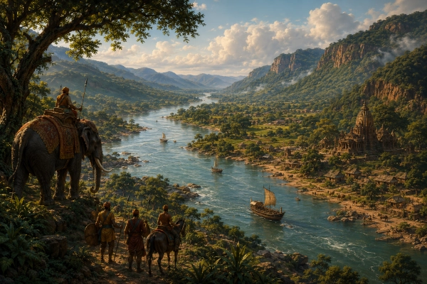
The landscape associated with Odra was dramatically different from the open plains of Kurukshetra. Great rivers cut through wooded hills, plateaus descended towards fertile valleys and forested uplands stretched across much of the interior. The Mahanadi formed the great natural artery of this country, carrying water and people between the western highlands and the eastern plains. Odra was therefore a land in which the river served not merely as a physical feature but as one of the principal roads through an otherwise difficult landscape.
Odra in the Mahabharata
The Mahabharata preserves Odra primarily as the name of a recognised people, the Odras or Audras, rather than giving us a long description of a clearly bounded kingdom. One of the most revealing references appears in connection with Yudhishthira’s Rajasuya sacrifice at Indraprastha. When the splendour of that imperial gathering is remembered, rulers and peoples from across Bharata are described as having assembled there, including the Vangas, Angas, Paundras and Odras.
This brief reference is geographically significant because Anga, Vanga and Pundra all belonged to the broad eastern world of ancient India, stretching through regions corresponding today to Bihar, Bengal and Bangladesh. Odra appears among these established eastern peoples, showing that the Odras were already sufficiently distinctive in the epic tradition to be remembered by name. Their inclusion in the Rajasuya also demonstrates that they belonged to the wider political network within which the Pandavas sought recognition of Yudhishthira’s imperial status.
The Rajasuya itself was far more than a religious ritual. It represented a public declaration that rulers from different parts of Bharata recognised Yudhishthira’s political authority. Representatives from distant regions therefore travelled enormous distances to reach Indraprastha. An Odra delegation would have left the river valleys and forested country of eastern India, crossed major river systems and passed through the Gangetic plains before eventually arriving at the Pandava capital.
Sahadeva and the Odras
Another important geographical clue appears during Sahadeva’s campaign in preparation for the Rajasuya. Sahadeva is described as travelling through a wide range of southern and southeastern regions while bringing rulers under Yudhishthira’s authority. Older translations contain a form rendered as “Udrakeralas,” while the Sanskrit can also be understood as referring to the Udras or Odras together with the Keralas.
This passage requires some caution because ancient textual traditions sometimes preserve names in different forms, and later translators occasionally combine terms that may originally have referred to separate peoples. It would therefore be misleading to imagine a single unified kingdom called “Udra-Kerala.” What matters for geographical reconstruction is that the Udras or Odras were remembered among the peoples of the wider southeastern and southern campaign zone.
The passage also illustrates how ancient geographical lists do not always follow the tidy sequence expected from a modern map. Regions could be grouped according to remembered campaigns, political relationships or textual traditions. Odra nevertheless appears clearly enough to demonstrate that it belonged to the recognised ethnogeography of the epic.
A People Before a Province
One of the most important points in understanding Odra is that ancient texts often speak first of the Odras as a people. The territorial term Odradesa, meaning the country of the Odras, became much more prominent in later historical sources. This suggests that the ethnonym may have existed before the geographical name developed into a widely recognised territorial designation.
Such a development was common in ancient India. A community could lend its name to the land it inhabited, and as rulers extended their political influence, the same territorial name could gradually spread over a much wider area. Over several centuries, what had once described the homeland of a particular people could become the name of a large cultural or political region.
Odra appears to have followed precisely this path. The Odras were first remembered as an eastern people, their land later became known as Odra or Odradesa, and over time that geographical tradition contributed to the emergence of the name Odisha. The names of the Odia people and the Odia language also belong to this long historical continuity. Few ancient regional names mentioned in the Mahabharata can be traced so directly into modern Indian identity.
The Mahanadi — The Great Artery of Odra
If one natural feature should dominate our reconstruction of Odra, it is the Mahanadi. The river approaches Odisha from the west after flowing through central India and enters the great valley around Sambalpur. From there it moves eastward across the interior, receiving major tributaries and passing through increasingly broken terrain before cutting through the Eastern Ghats at Satkosia. Beyond the gorge, the river eventually enters the broad coastal plains.
The Mahanadi corridor gave the region enormous strategic and economic importance. The river provided water for agriculture, fertile alluvial soil, fish and a natural line of communication through country that was otherwise heavily forested and difficult to cross. Its tributaries penetrated surrounding hills and uplands, linking smaller valleys with the main river system.
A traveller following the Mahanadi eastward would have watched the character of the landscape change gradually. Around the western valleys, cultivated fields would have appeared between forested slopes. Farther east, the hills increasingly enclosed the river. At Satkosia, the Mahanadi cuts dramatically between steep, wooded ridges before widening again as it moves towards the lower country.
In an age without surveyed roads or detailed maps, a great river served as a natural guide. The Mahanadi was therefore more than a source of water to ancient Odra. It was one of the principal organising features of the entire landscape.
Satkosia — Where the River Cuts Through the Hills
Few landscapes capture the geographical character associated with ancient Odra better than the Satkosia Gorge. Here the Mahanadi passes between long forested ridges, with wooded slopes descending almost to the water. Sandbanks appear along quieter stretches, while during the monsoon the river can transform into a vast torrent moving eastwards through the hills.
In the ancient world, this region would have been far more heavily forested than it is today. Human settlements would have clustered around clearings, river terraces and cultivable valleys, while large stretches of woodland remained beyond direct agricultural control. Elephants, deer, wild cattle, predators and numerous other animals would have occupied the surrounding forests.
The landscape also helps us understand the mixed social character of ancient eastern India. Odra would not have consisted solely of cities and settled agricultural villages. Forest communities, hill peoples, local chiefs and river-valley settlements would have existed alongside more organised political centres. Royal authority could be strong in cultivated valleys yet weaken rapidly in difficult upland terrain.
The Forest Behind the Kingdom
Much of central and western Odisha is composed of rolling uplands, plateaus, low mountain chains and heavily wooded valleys. In the world reflected by the Mahabharata, these forests would have been major sources of economic wealth. Timber could be used for buildings, carts, boats and weapons, while honey, wax, medicinal plants and other forest products could move towards larger settlements.
The forest was also politically important because it represented territory that could not always be governed in the same way as open agricultural country. Local communities possessed intimate knowledge of woodland routes, animal movements, streams and mountain passes. Kings therefore depended on alliances, tribute relationships and local intermediaries when attempting to control such regions.
Ancient political power was rarely represented by a uniform block of territory. A ruler might control major settlements and river corridors strongly while exercising only limited influence across forested uplands. Odra should therefore be imagined as a network of valleys, routes and centres of authority rather than as a sharply bounded region with evenly distributed control.
Elephants of the Eastern Forests
The forests of Odisha formed part of one of the great elephant habitats of the Indian subcontinent. Elephants were among the most valuable resources available to ancient eastern kingdoms because they could be captured, trained and used for transport, royal ceremony and warfare. Their presence gave forested regions immense strategic importance.
The Mahabharata repeatedly associates eastern kingdoms with powerful elephant forces, especially in descriptions of Kalinga and other neighbouring regions. Although the epic does not provide a detailed account of an Odra elephant army, the ecological environment of Odra would certainly have supported the same broader military culture.
A trained war elephant could dominate a battlefield. It could disrupt infantry formations, frighten horses and carry heavily armed warriors above the heads of surrounding soldiers. At the same time, elephants were symbols of royal prestige. A king who commanded large numbers of them visibly demonstrated access to wealth, forest resources and organised manpower.
Odra and Dakshina Kosala
Any attempt to place Odra across central and western Odisha requires an important qualification. Not all of western Odisha belonged to Odra, because large areas farther west were historically associated with Dakshina Kosala. That region extended through parts of western Odisha and present-day Chhattisgarh and possessed its own political and cultural identity.
For Mahabharata geography, the western side of Odra should therefore be imagined as a transitional zone rather than as a rigid frontier. Odra and Kosala were connected by the Mahanadi corridor, which allowed goods, travellers and armies to move between the interior and eastern Odisha. Political boundaries could change, but the river continued to bind these regions together.
This distinction is important because modern state boundaries can easily create the false impression that ancient regions corresponded neatly with present administrative divisions. In reality, western Odisha was historically shared among several cultural zones, and the relationship between Odra and Dakshina Kosala changed significantly through time.
Odra and Utkala
Odra must also be distinguished from Utkala. In later history, the two names became so closely associated that they were sometimes used almost interchangeably for Odisha. Earlier traditions, however, indicate that they could represent separate geographical regions.
For our Mahabharata reconstruction, Utkala is best visualised primarily across northern and coastal Odisha, with connections towards the northeastern uplands. Odra, by contrast, is placed more strongly within the central Mahanadi system and the interior country extending westwards from the coastal plain.
These distinctions should not be understood as precise political boundaries. The edges of both regions probably shifted according to ruling dynasties, migration, settlement and economic influence. Over the centuries, expanding kingdoms brought Odra and Utkala into closer political association, helping the names gradually converge within the broader identity of Odisha.
Odra and Kalinga
Odra should likewise remain distinct from Kalinga when reconstructing the Mahabharata period. Kalinga belonged more clearly to the maritime world of eastern and southern Odisha and extended towards the northern coastal districts of Andhra Pradesh. The epic gives Kalinga a more prominent military and dynastic identity, including royal figures and large battlefield contingents.
Odra appears more quietly in the narrative, but that does not mean it was unimportant. The Mahabharata gives enormous attention to some kingdoms while mentioning others only briefly. The appearance of the Odras at the Rajasuya is sufficient to demonstrate that they belonged to the recognised eastern political world of the epic.
Over later centuries, the identities of Odra and Kalinga became increasingly entangled as kingdoms expanded and dynasties ruled across multiple traditional regions. Later historical memory consequently associated both names with Odisha. For Mahabharata geography, however, preserving the distinction between them helps reveal the remarkable regional diversity of ancient eastern India.
An Inland Gateway to the Eastern Coast
Odra occupied an important strategic position between central India and the eastern seaboard. To the west lay the interior plateau and the routes towards Dakshina Kosala. To the north were uplands extending towards the Chhotanagpur region, while to the east the Mahanadi descended towards the broad plains approaching the Bay of Bengal.
This location made Odra an important corridor rather than an isolated inland region. Forest products, agricultural produce and minerals could move along its river valleys, while merchants and travellers passed between the interior and the coastal world. Religious ideas and cultural influences followed the same routes.
The Mahanadi therefore connected landscapes that otherwise appeared very different. It linked forested plateaus to agricultural plains and opened a path from central India towards the eastern coast. Odra stood at the heart of this meeting point.
Odra at Yudhishthira’s Rajasuya
The appearance of the Odras at Yudhishthira’s Rajasuya offers one of the clearest glimpses of their place in the political world of the Mahabharata. Delegations from distant regions arrived at Indraprastha carrying gifts and representing rulers from across Bharata. The city must have been crowded with kings, priests, retainers, animals and tribute from regions separated by hundreds or even thousands of kilometres.
The presence of the Odras demonstrated that the politics of the Kuru-Pandava heartland extended far into eastern India. Events in Indraprastha mattered even to rulers living among the forests and river valleys of distant Odra. By attending the Rajasuya, they participated in the wider network of political recognition that surrounded Yudhishthira’s claim to imperial status.
This episode also reminds us that ancient India was far more interconnected than geographical distance might suggest. Rivers, trade routes, pilgrimage networks, political campaigns and marriage alliances created continual movement across the subcontinent.
From Odra to Odradesa
As the epic age gave way to historically documented kingdoms, the name Odra continued to survive. By the early medieval period, inscriptions clearly refer to Odradesa and related territorial divisions. These records show that the geographical meaning of Odra changed considerably over time and that the region could expand beyond its earlier core.
Later inscriptions also associate the Odra name with portions of central Odisha, particularly areas within and around the Mahanadi system. Although these references belong to periods much later than the Mahabharata, they demonstrate the long historical connection between the Odra name and the inland river valleys of Odisha.
Over the centuries, dynastic expansion gradually merged territories that had once been remembered separately as Odra, Utkala, Kalinga and Kosala. The resulting political formations helped create the broader cultural landscape from which medieval and modern Odisha eventually emerged.
The Name That Became Odisha
Odra’s greatest legacy lies in the survival of its name. Over many centuries, forms such as Odra, Odradesa and related regional expressions contributed to the name Odisha. The development was gradual and passed through several linguistic stages, but the connection between ancient Odra and modern Odisha is widely recognised.
The same historical root is connected with the words Odia and the identity of the Odia-speaking people. In this sense, Odra is exceptional among the ancient regions mentioned in the Mahabharata. Many kingdoms such as Matsya, Chedi and Panchala survive mainly in literature, inscriptions and archaeological memory. Odra did not simply disappear; its name evolved and became attached to an entire modern state and linguistic civilisation.
This continuity gives the region extraordinary importance. A name that appears briefly among the peoples of the epic eventually became part of the everyday identity of millions of people.
Finding Odra in Today’s Landscape
To visualise ancient Odra today, the best guide is not a modern district boundary but the course of the Mahanadi. Beginning near the western river country around Sambalpur, the river moves through a landscape of valleys, forests and uplands before continuing towards Boudh and the central Odisha interior.
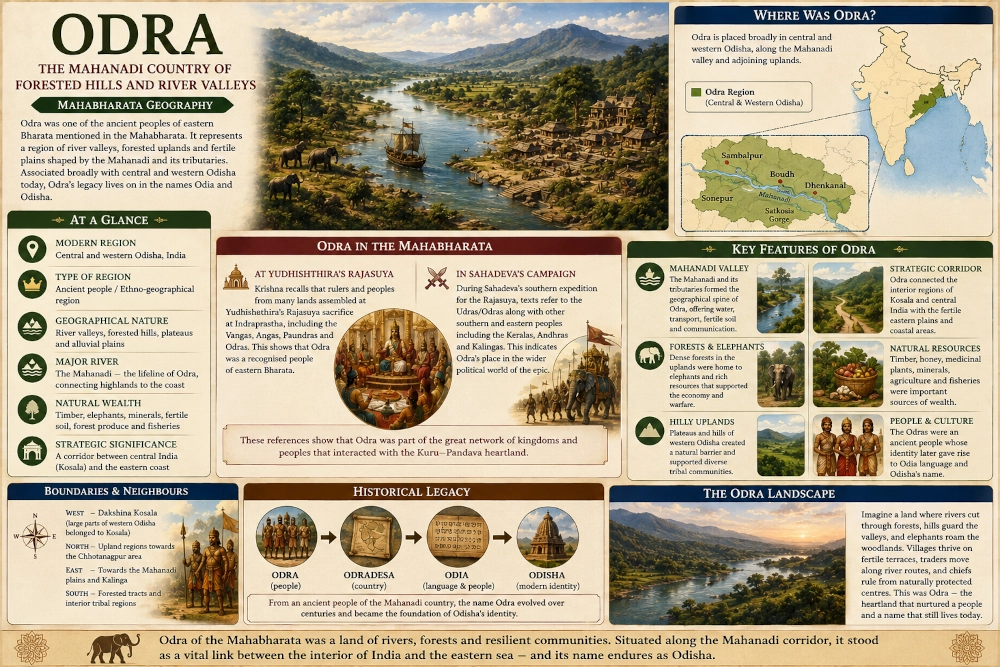
Farther east, the terrain becomes increasingly dramatic as the Mahanadi approaches Satkosia. The river cuts through long wooded ridges and then gradually emerges towards the more open country of central Odisha. This broad corridor provides one of the most convincing landscapes through which the ancient Odra region can be imagined.
The geography explains how the region could support both settled agriculture and extensive forest cultures. River valleys offered fertile land and communication routes, while the surrounding hills contained timber, wildlife and other natural resources. Odra was therefore defined by the interaction between river and forest rather than by either environment alone.
The Odra Countryside in the Epic Age
An early morning in ancient Odra might have begun with mist lying over the Mahanadi while the surrounding hills slowly emerged from darkness. Small boats would have crossed the river, farmers would have led cattle towards fields on fertile terraces and smoke from settlements would have risen above the tree line.
Beyond these cultivated clearings stretched dense forest. Elephant herds moved through the woodland, while hunters and forest communities followed routes invisible to outsiders. Traders carried produce between settlements, and messengers travelled along the river corridor towards the courts of local chiefs.
Farther west, the route eventually led towards Kosala and the interior plateau. Farther east, the Mahanadi opened towards the plains and the coastal world. News of events in distant Indraprastha could travel along these same routes, carrying word that Yudhishthira was preparing his great Rajasuya sacrifice.
Through these geographical connections, the apparently remote country of Odra was drawn into the great political world of the Mahabharata.
Odra — The Inland Heart of Ancient Odisha
Odra’s place in Mahabharata geography is quieter than that of Kalinga, but its historical significance is profound. The epic recognises the Odras as one of the peoples of Bharata and places them among the eastern delegations associated with Yudhishthira’s Rajasuya. Other textual traditions connect the Udras or Odras with the broader campaigns undertaken during the Pandavas’ rise to power.
For geographical reconstruction, Odra can therefore be understood broadly as a central Odisha and Mahanadi-valley region extending westward into the uplands, while recognising that its ancient boundaries were fluid and that large areas of western Odisha also belonged to the distinct world of Dakshina Kosala.
Its natural identity was shaped by the Mahanadi, forested hill ranges, fertile river valleys and the routes that connected central India with the eastern plains. These features made Odra an important inland bridge between the plateau country and the Bay of Bengal world.
Its greatest legacy, however, lies in the survival of its name. The ancient Odra remembered in epic and historical tradition gradually gave rise to Odradesa, Odia and Odisha. In that sense, Odra is more than another vanished territory on the map of the Mahabharata. It is one of the rare ancient regional names whose echo continues to define a living civilisation today.
You may also like
-
Sindhu: The Indus Kingdom of Jayadratha in the Mahabharata
-
Kuninda or Kulinda: The Himalayan Realm of the Mahabharata in Uttarakhand and Himachal Pradesh
-
Durga versus Mahishasura: Weapons, Battlefield Tactics and the Triumph of Shakti
-
Kuluta: The Kullu Valley Kingdom of the Mahabharata
-
Trigarta: The Kangra–Jalandhar Kingdom of the Mahabharata
