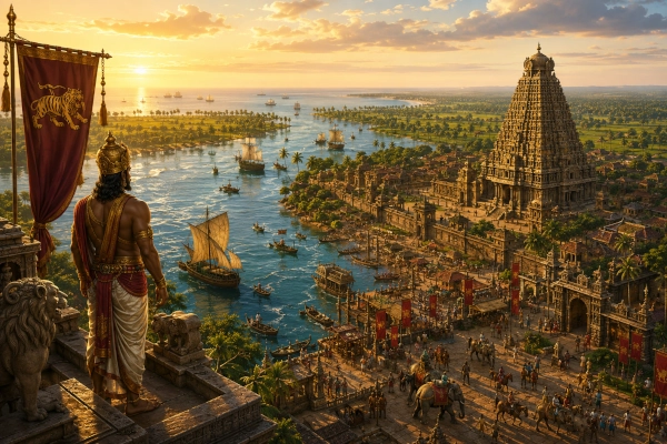
Mahabharata Geography — Chola
Modern geographical correspondence: Kaveri delta and central Tamil Nadu, India
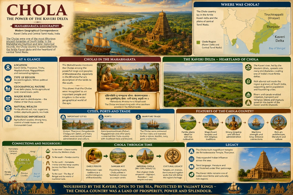
Across the southern peninsula, where the Kaveri leaves the rocky interior and begins spreading into one of India’s richest agricultural plains, lay the ancient country of the Cholas. In geographical terms, the Chola heartland corresponded broadly to the lower Kaveri basin and delta of present-day Tamil Nadu, extending from the Tiruchirappalli-Uraiyur region eastwards through the fertile country of Thanjavur, Kumbakonam and Mayiladuthurai towards the Bay of Bengal. The precise limits of Chola territory changed repeatedly through the centuries, but the Kaveri remained the geographical axis around which Chola political identity developed.
The Cholas are often remembered today through Rajaraja I, Rajendra I, the Brihadisvara Temple, great naval campaigns and the powerful empire of the ninth to thirteenth centuries CE. That magnificent Imperial Chola age, however, belongs many centuries after the world represented in the Mahabharata. The epic knows the Cholas much earlier simply as one of the recognised peoples and kingdoms of southern Bharata. They appear in its geographical catalogues, at Yudhishthira’s Rajasuya and eventually on the battlefield of Kurukshetra. Archaeology and early Tamil literature then allow us to follow the Chola name into the historically documented landscape of the Kaveri valley.
The result is one of the most compelling geographical continuities in the Mahabharata. The epic remembers a southern people called the Cholas, and subsequent history repeatedly places rulers bearing that name in precisely the great river country of central Tamil Nadu.
The Cholas in the Geography of the Mahabharata
The Bhishma Parva contains one of the Mahabharata’s extraordinary surveys of Bharatavarsha. After describing northern, eastern and central regions, the text turns towards the south and names numerous peoples including the Dravidas, Keralas, Mushikas, Vanavashikas, Karanatakas, Mahishakas, Kuntalas and Cholas. The placement leaves little doubt that the Cholas belonged to the recognised political geography of southern India.
This is significant because the epic does not describe the south as an undefined wilderness beyond the Vindhyas. It knows numerous distinct peoples occupying different parts of peninsular India. Kerala and Mushika belonged towards the western coast, Vanavasi to the Karnataka forest country, the Pandyas to the far south and the Cholas to the great eastern riverine plain associated with the Kaveri.
The Mahabharata also explicitly knows the Kaveri River. In its geographical enumeration of important rivers, the Bhishma Parva names the Kaveri among the waters of Bharatavarsha. The Vana Parva’s pilgrimage geography later describes the Kaveri as a sacred river frequented by celestial beings and tells the pilgrim of the merit obtained by bathing in its waters.
The epic therefore preserves both components of the later geographical identification: the Chola people and the Kaveri landscape.
The Cholas at Yudhishthira’s Rajasuya
The Cholas appear again in one of the most important political gatherings in the Mahabharata. Looking back upon Yudhishthira’s lost prosperity after the dice game, Krishna remembers the extraordinary assembly of rulers who had attended the Rajasuya sacrifice at Indraprastha. Among them he specifically names the Vangas, Angas, Paundras, Odras, Cholas, Dravidas and rulers of numerous maritime and frontier countries.
This brief passage tells us considerably more than a geographical list.
The Cholas were understood as part of the network of recognised kingship that stretched across Bharata. A ruler or delegation from the distant Kaveri country could travel northwards and participate in a ceremony held at Indraprastha, hundreds of kilometres from the Tamil plains. The journey itself would have crossed several political regions, rivers and ecological zones.
Imagine representatives departing from the Kaveri valley. Behind them lay wet fields, river channels and palm-lined settlements. Their route took them northward through the Deccan and eventually into the great plains of northern India. When they reached Indraprastha they encountered delegations from almost every direction of the subcontinent, speaking different languages and bringing regional products, animals, textiles, ornaments and tribute.
Among that multitude stood the Cholas of the southern country.
Their presence at the Rajasuya demonstrates that the epic imagined the political world of the Kaveri as connected to the affairs of the Pandavas and Kurus.
The Cholas at Kurukshetra
The most striking Chola reference comes during the Kurukshetra War itself.
In the Karna Parva, the Pandava forces advance against the Kauravas in a vast formation. The text specifically mentions the Dravida forces, the Pandyas, the Cholas and the Keralas, grouped around Satyaki and the advancing Pandava army. The description portrays these southern troops as powerful warriors moving forward amid elephants, cavalry, chariots and infantry.
This places Chola warriors firmly on the Pandava side during the later stages of the war, at least in the formation described in the Karna Parva.
The geographical scale of the moment is remarkable. Men from the Kaveri plain had supposedly travelled from the southeastern coast of the peninsula all the way to Kurukshetra. Beside them fought Pandyas from farther south, Keralas from beyond the Western Ghats, along with Chedis, Panchalas, Kaikeyas, Magadhas and numerous other contingents.
The battlefield therefore became a convergence point for the political geography of the entire epic.
For the Cholas, this passage is especially valuable because they cease to be merely a name in a catalogue. Their warriors stand within the Pandava host and enter directly into the central military narrative of the Mahabharata.
Krishna and the Cholas
Another passage in the Drona Parva recalls the extraordinary martial career of Krishna and lists various peoples whom he had defeated or overcome. Among those named are the Cholas and Pandyas, alongside several other kingdoms from across India. The passage belongs to the epic’s heroic tradition surrounding Krishna rather than to a detailed historical campaign itinerary, so it should not be used to reconstruct a precise invasion route. Nevertheless, it provides further evidence that the Cholas were regarded as a recognised southern political power within the epic’s geographical imagination.
Taken together, these references create a surprisingly substantial picture. The Cholas are listed among the southern countries, their rulers appear among those associated with the Rajasuya, Chola troops fight alongside the Pandavas at Kurukshetra, and their name occurs in traditions recounting the military achievements of Krishna.
The Cholas were therefore not a later dynasty artificially projected backwards into the epic. The Chola name itself belongs securely to ancient Indian geographical tradition.
The Kaveri — The River That Created Chola Country
To understand Chola geography, one must first understand the Kaveri.
The river descends from the Western Ghats in Karnataka, crosses the southern Deccan and eventually enters Tamil Nadu. By the time it reaches the Tiruchirappalli region, the landscape changes dramatically. The river approaches flatter country and begins the process of division that eventually creates the immense network of channels forming the Kaveri delta.
Ancient Chola country grew around this transformation.
The river and its branches deposited rich alluvial soils across the plains. Seasonal water could be diverted towards fields. Tanks, channels and later increasingly sophisticated irrigation works allowed agricultural settlements to spread across the lower basin.
The Kaveri consequently became more than a river. It was the economic foundation of Chola political power.
Fields fed by its waters produced agricultural surpluses capable of supporting towns, craftsmen, merchants, temples and armies. Villages clustered along irrigation channels, while roads followed the river eastwards towards the coastal world. Over many centuries this combination would make the Kaveri delta one of the richest agricultural regions of southern India.
Where the River Divides
Near Tiruchirappalli, the Kaveri approaches the great island of Srirangam and divides into channels, including the northern branch now known as the Kollidam. Farther downstream, the system divides repeatedly through the delta.
For anyone approaching from the drier interior, the change in landscape would have been dramatic. The country becomes flatter and greener. Water appears almost everywhere: rivers, irrigation channels, ponds, tanks and flooded rice fields reflecting the sky.
During the agricultural season, paddies stretch across broad plains interrupted by groves of trees and raised settlements. Bunds separate one field from another, while channels carry Kaveri water into areas that would otherwise depend much more heavily upon uncertain rainfall.
This watery geography became one of the strongest defensive and economic advantages of the Chola country. Armies unfamiliar with the delta had to negotiate rivers and canals. Local rulers, by contrast, understood the crossings, embankments and seasonal behaviour of the waterways.
The Kaveri was simultaneously lifeline, road, frontier and fortress.
Uraiyur — The Inland Capital Beside the Kaveri
One of the strongest archaeological anchors for the early Chola heartland is Uraiyur, today incorporated within Tiruchirappalli.
Archaeological Survey of India reports identify Uraiyur explicitly as the ancient capital of the Cholas. Excavations revealed substantial occupation beginning in the early historic period, including black-and-red ware, rouletted ware, structural remains and evidence for later flooding and waterlogging from the nearby Kaveri.
The location makes excellent geographical sense.
Uraiyur stood near the point at which the Kaveri began opening towards the delta. A ruler based here could command routes coming eastwards from the interior while also controlling access towards the extraordinarily productive lower river country.
From Uraiyur, the Chola domain opened eastward like a fan.
River routes led towards the fertile plains of Thanjavur. Farther downstream lay settlements connected by distributaries and irrigation channels. Eventually the river reached the Bay of Bengal at the great maritime settlement remembered as Kaveripattinam or Puhar.
Uraiyur therefore represented the inland political doorway to Chola country.
Early Chola Country Before the Imperial Cholas
The archaeological importance of Uraiyur helps distinguish two very different phases of Chola history.
The early Cholas, known from Tamil literary traditions and early historical evidence, belonged principally to the Kaveri country centred on places such as Uraiyur and Kaveripattinam. The magnificent Imperial Cholas who later ruled from Thanjavur and Gangaikondacholapuram emerged many centuries afterward.
This distinction matters for a Mahabharata Geography article.
When the epic speaks of the Cholas, it cannot be referring to Rajaraja I’s eleventh-century administrative system, Rajendra’s overseas expedition or the great stone temples that later transformed the landscape. Those achievements belong to a subsequent historical civilisation that inherited the much older Chola name and Kaveri homeland.
What connects the periods is geography.
The Kaveri basin remained the political core.
The Kaveri Delta — Granary of the Chola Country
East of Tiruchirappalli, the Kaveri country opens into a broad and extraordinarily fertile plain. The modern districts surrounding Thanjavur, Kumbakonam, Thiruvarur and Mayiladuthurai preserve the essential geography that later made Chola Nadu famous.
The land is low and river-built. Numerous branches of the Kaveri carry water across the plain before eventually reaching the Bay of Bengal. Rice cultivation became particularly important because the flat terrain and abundant irrigation created ideal conditions for wet agriculture.
The visual character of the country is distinctive. Unlike regions dominated by one huge river channel, the Kaveri delta is a web of water. A traveller may cross one distributary, walk through several kilometres of fields and encounter another channel beyond the next settlement.
This explains why the later Chola kingdom could sustain unusually dense networks of villages and temples. Agricultural productivity generated surplus, and surplus created political power.
The origins of that relationship between the Cholas and their riverine heartland almost certainly reach much further back than the monumental architecture of the medieval dynasty.
Kallanai and the Long History of Irrigation
One of the greatest symbols of the Kaveri’s transformation into an agricultural landscape is Kallanai, the ancient Grand Anicut constructed across the river downstream from Tiruchirappalli. Tamil historical tradition associates the structure with the early Chola ruler Karikala, and it became central to the diversion and management of Kaveri waters across the delta.
Kallanai belongs to the early historical Chola world rather than securely to the period represented by the Mahabharata, so it should not be presented as an epic-age structure. Nevertheless, it illustrates a geographical reality that must have existed long before its construction: controlling the waters of the Kaveri was fundamental to controlling Chola country.
The river brought prosperity, but unmanaged water could also bring destruction. Archaeological excavations at Uraiyur found evidence of flooding and waterlogging severe enough to influence settlement patterns.
The history of Chola civilisation was therefore partly a history of learning how to live with the Kaveri—capturing its water when possible and surviving its force when necessary.
Puhar — Where Chola Country Met the Sea
At the eastern end of this river world lay the great port known as Kaveripattinam, Kaveripoompattinam or Puhar, near modern Poompuhar in Mayiladuthurai district.
The Government of Tamil Nadu describes Poompuhar as an ancient flourishing port situated near the mouth of the Kaveri and identifies it as a capital of the early Chola kings. Archaeological Survey of India investigations likewise describe Kaveripattinam as the best-known port city of the Tamil Cholas and document extensive early historical occupation around the site.
Here the geography of Chola country reached its natural conclusion.
Water that had travelled across the peninsula finally entered the Bay of Bengal. Goods produced throughout the Kaveri basin could move downstream towards the coast. Agricultural produce, textiles and other commodities from the interior could reach merchants arriving by sea.
Puhar therefore linked the river economy with the maritime economy.
Although the elaborate overseas commercial networks known from later Sangam and historical evidence should not simply be projected unchanged into the Mahabharata period, the natural geographical advantage existed regardless of date. The Kaveri provided a corridor from the interior directly to the eastern sea.
A Kingdom With Two Faces
This gave Chola country a character unlike many inland kingdoms of the epic.
Its western face looked towards the interior of Tamil Nadu and the routes leading towards Kongu country and the plateau beyond.
Its eastern face opened upon the Bay of Bengal.
Between them lay the Kaveri.
A Chola ruler could therefore draw wealth from fertile agriculture while also maintaining access to maritime routes. Few geographical combinations were more favourable to political growth.
This dual orientation would become spectacularly important during the later Imperial Chola age, when rulers of the Kaveri delta developed one of premodern India’s greatest maritime powers. But its origins lay in the basic physical geography of the region.
The Cholas inherited a country naturally connected both inland and overseas.
Chola and Pandya — The Two Great Tamil Countries
South of the Chola heartland lay Pandya country, centred farther south around the Vaigai basin and Madurai.
The Mahabharata repeatedly recognises the Pandyas separately from the Cholas. Both appear within the epic’s knowledge of southern India, and in the Karna Parva their troops are found together among the Pandava forces.
This distinction is important because later popular accounts sometimes speak vaguely of ancient “Tamil kingdoms” without preserving their individual geography.
Chola and Pandya were not interchangeable names.
The Chola core belonged to the Kaveri.
The Pandya core belonged farther south, particularly to the Vaigai and the deep southern Tamil country.
Political boundaries between them changed repeatedly, and later wars between Cholas and Pandyas would dominate centuries of Tamil history. Yet their separate identities were already established deeply within southern India’s geographical traditions.
Chola and the Western Country
To the west of the Kaveri plain rose progressively higher country leading towards Kongu and ultimately the Western Ghats.
This landscape formed another important frontier.
The lower Kaveri valley provided routes westwards from Uraiyur and Tiruchirappalli towards Karur and the interior. Through these corridors the Chola country could interact with the western side of Tamilakam and with routes eventually approaching the Chera or Kerala world.
The contrast between these environments was substantial. The central Kaveri plain contained extensive cultivation and riverine settlements. The western uplands were more broken and increasingly influenced by hill and forest systems.
For Chola rulers, controlling the inland approaches to the delta was therefore strategically essential.
Uraiyur’s location again becomes understandable: it stood where the riverine plains and routes from the west met.
Chola and the Northern Tamil Country
North of the principal Chola heartland lay regions that would later be associated with Tondai Nadu and the Kanchi country, while intermediate territories shifted frequently between larger powers.
Ancient Chola territory should consequently not be drawn to the modern northern boundary of Tamil Nadu. Its safest geographical core lies much farther south, along the lower Kaveri.
Over time powerful Chola rulers expanded enormously beyond this heartland. The Imperial Cholas eventually governed almost all of Tamil Nadu and projected power across southern India and beyond.
Yet expansion should never be confused with origin.
The homeland remained Chola Nadu—the Kaveri country.
The Chola Landscape Before the Great Temples
Modern visitors travelling through Thanjavur naturally associate the region with towering medieval temples. The enormous vimana of Brihadisvara dominates the historical imagination, while Gangaikondacholapuram recalls Rajendra I and the zenith of Chola imperial power.
None of those monuments existed in the Mahabharata world.
To imagine the earlier landscape, they must mentally be removed.
In their place picture settlements built largely from timber, brick, earth and perishable materials. Fields spread between river channels. Shrines stood among groves. Boats crossed waterways. Earthen embankments protected cultivated land. Chiefs and rulers occupied defended settlements whose monumental traces may have disappeared almost entirely.
The land itself is the more enduring monument.
The Kaveri, its floodplain and the broad delta existed long before Rajaraja raised stone temples above them.
The Kaveri as Sacred Geography
The Mahabharata does not treat the Kaveri merely as a practical river.
In the Vana Parva’s pilgrimage itinerary, the river appears as a sacred tirtha. A pilgrim who bathed in the Kaveri was promised great religious merit.
This is an important reminder that geography in the epic operates simultaneously on several levels.
A river could sustain agriculture, define a political region and serve as a sacred landscape. Travellers followed its banks not only because water made movement easier but because pilgrimage sites attracted religious communities from distant parts of India.
The Kaveri therefore helped connect southern Tamil country with the wider sacred geography of Bharata.
A pilgrim approaching from northern India did not enter an unknown cultural wilderness upon reaching the Tamil south. The river itself belonged to a pan-Indian network of sacred waters known to the epic tradition.
Life Along the Ancient Kaveri
Imagine the Chola country during the beginning of the agricultural season. Water released across the river system enters smaller channels and spreads towards prepared fields. Farmers repair bunds while cattle pull implements through softened earth. Villages rise slightly above the wet ground, shaded by trees.
Along the riverbank, boats carry passengers and agricultural produce.
At a larger settlement, craftsmen work in pottery, metal and textiles. Traders prepare goods for transport downstream. Messages arrive from neighbouring chiefs. Priests maintain sacred fires and shrines. Warriors attached to the ruler watch the river crossings.
Farther east the landscape becomes increasingly flat until the horizon merges almost imperceptibly with the coast.
At Puhar, river water meets salt water.
Ships and smaller coastal craft wait beyond the mouth of the Kaveri. Merchants hear languages from regions far beyond the delta, while products from the interior accumulate near the harbour.
This combination of field, river, town and sea defined Chola geography.
From Epic Chola to Sangam Chola
The historical record becomes much clearer in the centuries associated with early Tamil literature. Sangam traditions remember Chola rulers connected with Uraiyur and Kaveripattinam, confirming the geographical association of the Chola name with the Kaveri basin.
Government records for the Tamil Nadu region likewise describe Uraiyur as a Sangam Chola centre, while archaeological investigations establish substantial early occupation there.
Among the best-known early Chola figures is Karikala Chola, remembered in Tamil tradition as a ruler closely associated with the Kaveri and the development of its agricultural landscape.
These rulers belong to the historical and literary world following the formation of the Mahabharata traditions. They should not be casually inserted into the epic narrative.
Their importance for us is geographical.
When Tamil sources begin describing identifiable Chola rulers, those rulers appear exactly where we would expect them: along the Kaveri.
From the Early Cholas to the Imperial Cholas
Many centuries later, the Chola name rose again with extraordinary power.
Beginning in the ninth century CE, rulers such as Vijayalaya, Aditya I and Parantaka expanded Chola authority. Thanjavur became an important royal centre, and under Rajaraja I and Rajendra I the kingdom developed into a vast imperial power.
The Kaveri heartland financed that expansion.
The same agricultural landscape that had sustained earlier Chola polities now supported a sophisticated medieval state. Irrigation networks, densely organised villages and substantial agricultural revenues helped finance monumental temples, professional military forces and maritime expeditions.
Rajaraja’s Brihadisvara Temple at Thanjavur and Rajendra’s Gangaikondacholapuram belong to this later age. They are spectacular evidence of what the ancient Chola homeland eventually became, but they should be understood as the culmination of a long regional history rather than as monuments of the epic period.
The continuity lies in the name and the river.
The Cholas and the Eastern Sea
By the Imperial period, the maritime potential of the Chola homeland became unmistakable. Fleets crossed the Bay of Bengal, commercial connections reached Southeast Asia and Chola political power extended far beyond Tamil Nadu.
Yet the foundation of that maritime orientation existed much earlier in the geography of the Kaveri delta.
A river leading directly into the Bay of Bengal naturally encouraged contact with the sea. Coastal settlements could communicate northwards and southwards along the Coromandel shore. Inland goods could reach coastal markets through the delta.
This is why Puhar became so important in early Tamil memory and archaeology. It occupied precisely the point where the agricultural wealth of the Chola interior encountered the maritime world.
The sea was consequently not a remote boundary of Chola country.
Like the Kaveri itself, it was a pathway.
The Problem of Drawing Chola on a Mahabharata Map
Any map of Mahabharata Chola should remain deliberately approximate.
The epic gives us the name of the people but does not provide a surveyed border. Later evidence strongly connects the Cholas with the lower Kaveri, yet the territorial reach of particular Chola rulers changed continually.
The safest core would stretch broadly from the Tiruchirappalli-Uraiyur region eastward across the Kaveri delta through the Thanjavur country towards Kaveripattinam on the Bay of Bengal.
The region would include much of what later became known as Chola Nadu in central and east-central Tamil Nadu.
Its western edge should fade towards the inland and Kongu-connected country. To the south lay the approaches towards Pandya territory, while to the north were other Tamil regions whose political relationship with the Cholas changed repeatedly.
The resulting map should therefore show a geographical heartland rather than an imperial frontier.
Chola at Kurukshetra — From the Kaveri to the Kuru Plain
The appearance of Chola troops at Kurukshetra provides perhaps the most powerful image with which to connect this distant southern geography to the central story of the Mahabharata.
Consider the distance they had travelled.
They left behind the Kaveri, its green fields and humid delta. Their route carried them northwards through peninsular India, across rivers and plateaus, eventually into a climate and landscape entirely different from their own.
At Kurukshetra they stood beside Pandya and Kerala troops and among an enormous coalition assembled around the Pandavas. The Karna Parva remembers these southern contingents advancing into battle as part of the Pandava host.
Whatever historical processes ultimately produced the epic’s description, its geographical imagination is extraordinary.
A conflict between cousins belonging to the Kuru dynasty had become a war involving peoples from the Kaveri delta, Kerala, the deep Tamil south, eastern India, the northwest and the Himalayan world.
Chola belonged fully to that conception of Bharata.
Finding Chola Country Today
To find the geographical heart of ancient Chola today, begin at Tiruchirappalli.
Near the Kaveri lies Uraiyur, remembered by archaeology and Tamil tradition as an early Chola capital. Follow the river eastwards and the terrain begins opening into the great delta. The countryside becomes increasingly dominated by irrigation channels and cultivated fields.
Continue towards Thanjavur, and the agricultural wealth of the region becomes obvious. The later Chola temples rise above a landscape created fundamentally by river water.
Move farther east through Kumbakonam and Mayiladuthurai, and the network of branches becomes even more intricate.
Eventually the land reaches Poompuhar, where the Kaveri enters the Bay of Bengal and where the ancient Chola port of Kaveripattinam once flourished. The modern district administration still identifies Poompuhar with the ancient Kaveri Poompattinam and the early Chola political tradition.
This journey from Uraiyur to the sea follows the geographical spine of Chola country.
The Chola Country in the Epic Age
Imagine dawn appearing over the eastern horizon before the heat of the day.
Mist hangs above a branch of the Kaveri. Birds gather along the wet fields while farmers begin moving towards the paddies. Water runs quietly through irrigation channels cut into the rich dark soil.
A small settlement awakens beside the river. Boats are pushed into the current, traders prepare loads for transport and cattle move along raised paths between the fields.
Farther upstream lies the political centre around Uraiyur.
Farther downstream, water divides repeatedly until it reaches the sea.
News travels along these roads and waterways that a northern monarch named Yudhishthira is preparing a Rajasuya. At some point, representatives of the Chola ruler undertake the long journey to Indraprastha.
Years later the political crisis of the Kuru family becomes war.
Warriors from the same distant southern country travel north once again, this time carrying bows, swords and shields. Eventually they stand alongside the forces of the Pandavas on the plain of Kurukshetra.
Behind them, far away, the Kaveri continues flowing towards the Bay of Bengal.
Chola — The Kingdom Created by the Kaveri
Among the southern regions remembered by the Mahabharata, Chola possesses an unusually powerful continuity between epic geography and later history. The Bhishma Parva names the Cholas among the recognised kingdoms of southern Bharata. Krishna remembers Chola rulers at Yudhishthira’s Rajasuya, while the Karna Parva places Chola troops alongside the Pandyas and Keralas within the Pandava army. The epic separately knows and venerates the Kaveri, the very river that later historical and archaeological evidence identifies as the heart of Chola civilisation.
For our Mahabharata Geography reconstruction, Chola can therefore be placed confidently in the Kaveri delta and central Tamil Nadu, with its principal geographical axis running from Uraiyur and the Tiruchirappalli region eastwards through the lower Kaveri plains to the Bay of Bengal.
Its defining landscape was neither mountain nor desert. It was water.
The Kaveri descended from the interior, divided across the plains and transformed the country through which it flowed. Its waters created fertile fields, nourished settlements, provided routes of communication and finally reached the sea at a port that would become one of ancient Tamilakam’s most celebrated maritime centres.
Centuries after the world remembered in the Mahabharata, this same landscape would produce one of India’s greatest imperial dynasties. Chola armies would march across southern India, Chola ships would cross the Bay of Bengal and enormous stone temples would rise above the Kaveri plain.
Yet beneath that later grandeur remained the older geographical reality.
Before Chola became an empire, it was a river country.
It was the fertile land of the Kaveri—the southern kingdom whose warriors were remembered in the Mahabharata, whose rulers entered the political world of Yudhishthira and whose name would survive across centuries until it became inseparable from one of the most remarkable civilisations in Indian history.
You may also like
-
Mushika — The Northern Malabar Kingdom Beneath Ezhimala and Beside the Arabian Sea
-
Tosala — The Ancient Heartland of the Daya, Mahanadi and Odisha’s Coastal Plain
-
Odra — The Mahanadi Country of Forested Hills and River Valleys
-
Utkala — The River-Bound Eastern Land Between the Highlands and the Sea
-
Kalinga — The Eastern Kingdom Between Mahendra and the Sea
