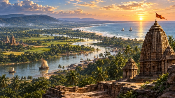
Along the eastern edge of Bharata lay a country where broad rivers left the wooded interior and spread across immense alluvial plains before meeting the Bay of Bengal. Northward, the land rose towards the forested plateaus adjoining Chhotanagpur; westward lay broken hill country leading towards Mekala and the interior; eastward stretched the sea. This was the geographical world associated with Utkala, one of the eastern peoples named in the Mahabharata.
In modern geographical terms, Utkala is most usefully associated with northern and coastal Odisha, although its boundaries cannot be drawn with the precision of a modern state. Ancient texts use Utkala in different geographical contexts, and its extent appears to have changed considerably through time. In later historical usage, the name expanded so widely that Utkala eventually became almost synonymous with Odisha itself. In the epic geographical setting, however, it is better understood as a distinct eastern region adjoining Kalinga, Odra and the lands towards Mekala, rather than simply another name for all of Odisha.
Utkala in the Geography of Bharata
The Bhishma Parva contains one of the great geographical catalogues of the Mahabharata. As the regions and peoples of Bharatavarsha are enumerated, the text names the Dasharnas, Mekalas and Utkalas in succession. Elsewhere in the same catalogue appear Kalinga, Anga, Vanga, Andhra, Pundra, Tamralipta and numerous other eastern and southern peoples. Utkala therefore belonged firmly within the epic’s mental map of India.
The placement beside Mekala is particularly interesting. It suggests that the geographical imagination surrounding Utkala did not concern the coast alone. Routes from the eastern plains ran inland towards forested highlands and ultimately towards the central Indian hill systems. Some historical-geographical studies have consequently argued that the earliest Utkala may have extended farther northwest than the later coastal Utkala known from medieval records.
This uncertainty is important. There was almost certainly no permanently surveyed boundary separating Utkala from neighbouring regions. Political power, settlement patterns, tribal territories and dynastic expansion could all alter the meaning of a regional name.
For the geography of the Mahabharata, the safest reconstruction is therefore of an eastern land centred broadly upon northern Odisha and connected both to the Bay of Bengal coast and to the forested country toward the west and northwest.
A Landscape Built by Great Rivers
To picture Utkala, the reader should first imagine water.
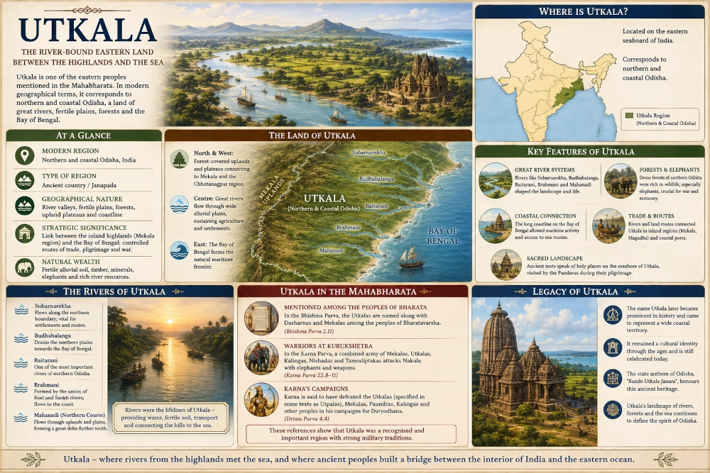
Several of eastern India’s great rivers descend through Odisha before reaching the Bay of Bengal. The Subarnarekha, Budhabalanga, Baitarani, Brahmani and Mahanadi create a succession of valleys, floodplains, wetlands and deltas across northern and coastal Odisha. The modern Odisha coastal plain remains one of India’s great river-built landscapes, while the terrain farther inland rises through plateaus and hills.
This geography must have profoundly shaped ancient settlement.
During the monsoon the rivers could swell enormously, breaking into channels and flooding low-lying land. When the waters withdrew, they left behind fertile soil. Rice and other crops could thrive in the humid plains, while river channels provided natural routes between settlements.
Travel, however, was rarely simple. A traveller moving north or south through Utkala could encounter wide rivers, marshes, densely vegetated banks and seasonal floodwaters. Roads had to accommodate ferry crossings and changes in the courses of rivers. Beyond the plains, thick forest and hills complicated journeys even further.
From an elevated position near the edge of the uplands, the country would have appeared as bands of green stretching towards a distant eastern horizon: forest close at hand, cultivated plains beyond, ribbons of water shining beneath the sun and, farther away, the Bay of Bengal.
Between Mekala and the Eastern Sea
One of Utkala’s most significant geographical characteristics was its position between two very different worlds.
To the west and northwest lay hills and plateaus connecting the region with the interior of India. The Mahabharata’s repeated association of Utkalas with Mekalas reflects this inland orientation. The Mekalas belonged to the great hill-country surrounding the upper Narmada and Maikal region. Ancient routes linking these regions would have passed through extensive forests and upland valleys.
To the east, however, lay the Bay of Bengal.
This gave Utkala a second orientation entirely. River mouths and coastal settlements opened towards maritime movement, fishing and eventually long-distance commerce. Odisha’s later history became famous for seafaring networks across the Bay of Bengal, although those later achievements should not automatically be projected unchanged into the age represented by the Mahabharata. What matters for epic geography is that the eastern sea formed a major natural boundary and cultural horizon of the region.
Utkala thus occupied a geographical transition zone: highland routes behind it, river plains at its heart and the ocean before it.
The Sacred Seashore of Utkala
The Mahabharata’s pilgrimage geography provides an especially evocative glimpse of this eastern coastal world.
During the Pandavas’ pilgrimage, Yudhishthira and his companions are led through sacred regions of eastern India. A tradition preserved in the epic describes a great sacred Vedi, or altar-like place, near the sea. Odisha scholarship has associated this passage with the seashore of Utkala and with the sacred geography that later developed around Purushottama Kshetra. The place is described as rising prominently near the ocean and connected with ancient sacrificial mythology.
The significance of the passage goes beyond religion.
It shows how the eastern coastline could itself become sacred geography. The ocean was not simply the end of the road. Rivers, forest clearings, elevated ground, shrines and the shoreline could become stations within pilgrimage networks stretching across the subcontinent.
Imagine the Pandavas approaching the eastern sea after weeks of travelling through river valleys and forests. The air becomes heavier with moisture. Salt begins to mingle with the smell of vegetation. The sound of waves grows louder beyond belts of trees and dunes. Then the horizon suddenly opens into an apparently limitless sheet of water.
For travellers coming from the continental interior, the Bay of Bengal must have been an extraordinary sight.
Utkala, Odra and Kalinga — Three Names, Not One Territory
One of the greatest difficulties in reconstructing ancient Odisha is the temptation to treat Utkala, Odra and Kalinga as interchangeable names.
Later usage often blurred these distinctions. Utkala eventually became a poetic and cultural name for Odisha as a whole, while Kalinga likewise became deeply associated with Odisha’s historical identity. The Government of Odisha itself notes that the region was known under names including Kalinga, Utkala and Odradesha during different periods.
But this later convergence should not be projected backwards too rigidly.
Ancient and early-medieval records sometimes distinguish Utkala from Odra, while literary sources distinguish Utkala from neighbouring Kalinga. Historical scholarship based on inscriptions likewise shows that Odra and Utkala could denote different territories before later political developments brought their names into closer association.
For our Mahabharata geography, it is therefore useful to think of eastern India as a mosaic.
Kalinga lay principally farther south along the Odisha-Andhra coastal world.
Utkala occupied a more northern zone, with strong links both to the coast and towards the inland highlands.
Odra represented another neighbouring population and territory whose exact limits also shifted through time.
The borders between them were not modern lines. They were transition zones formed by rivers, forests, hills, settlements and changing political influence.
The Northern Heartland
Northern Odisha gives Utkala much of its distinctive geographical character.
Here the flat coastal plains begin to meet the uplands associated with modern Mayurbhanj, Keonjhar and neighbouring areas. The Subarnarekha, Budhabalanga and Baitarani descend through this landscape. Beyond them rise extensions of the Chhotanagpur Plateau, creating a rugged transition between eastern India and the interior.
This helps explain why ancient geographical traditions could associate Utkala both with coastal Odisha and with regions farther inland.
It was not necessary for ancient inhabitants to choose between being a coastal people and a hill-connected people. River valleys linked the two environments. Forest products, animals, metals, agricultural goods and people could travel down from the uplands towards the plains, while salt and coastal produce could move inland.
The landscape would also have supported significant elephant populations. Forested eastern India was one of the great elephant zones of the subcontinent, making elephants important economically, ceremonially and militarily.
That military association becomes particularly visible when the Utkalas appear at Kurukshetra.
Utkala’s Warriors in the Kurukshetra War
The Mahabharata does not merely list Utkala among the countries of India. Utkala warriors eventually appear in the war itself.
During the Karna Parva, a combined body of Mekalas, Utkalas, Kalingas, Nishadas and Tamraliptakas advances against Nakula. The warriors attack with arrows and lances, while elephants play a conspicuous role in the fighting. Nakula, Sahadeva and other Pandava warriors respond with volleys of arrows against the advancing elephant force.
The passage is important because it brings together peoples whose territories stretched across eastern and central India.
Mekala represented the upland interior. Kalinga lay along the southeastern coast. Tamralipta belonged to the great coastal-commercial world farther north. Utkala stood geographically between several of these spheres.
The combined formation therefore makes geographical sense.
The battlefield description is ferocious. Elephants advance under showers of missiles. Their riders cast weapons from above while Pandava archers attempt to stop them. Animals collapse under concentrated arrow fire, and the formation eventually breaks.
The scene gives the Utkalas a tangible presence in the epic. They are no longer simply a name in a list of distant peoples; they have travelled from eastern India to Kurukshetra and entered the central struggle of the Mahabharata.
Karna and the Eastern Peoples
Another passage remembers Karna’s earlier military activity across a wide range of kingdoms.
When Bhishma speaks of Karna’s achievements, the text names the Utpalas/Utkalas, Mekalas, Paundras, Kalingas, Andhras, Nishadas, Trigartas and Valhikas among peoples he had defeated while acting in support of Duryodhana. The manuscript tradition varies in the form of the Utkala name in this passage, with Ganguli’s translation rendering it as “Utpalas.”
The sequence again reinforces the enormous geographical reach of Kuru politics.
Hastinapura may have stood in northern India, but Duryodhana’s alliances and Karna’s campaigns reached deep into the east, south and northwest. Utkala consequently formed part of the much larger political network within which the Kurukshetra conflict developed.
For a ruler of Hastinapura, controlling or securing the allegiance of eastern territories was valuable not merely for prestige. Such regions could contribute troops, elephants, resources and access to routes running towards the coast.
Rivers as Roads Through Utkala
Modern maps encourage us to think primarily in terms of roads. Ancient geography worked differently.
Rivers often provided the clearest corridors across difficult terrain.
The Baitarani and Brahmani systems, for example, connect the hills and mineral-bearing uplands of northern Odisha with the lower coastal country. The Mahanadi does the same on a much larger scale farther south. The coastal plains are composed largely of sediment brought down by such rivers over immense periods.
Settlements naturally grew close to water, but not necessarily directly on unstable riverbanks. Communities had to balance access to water against the dangers of flooding. Boats, ferries and seasonal crossings became essential components of travel.
The pattern also explains how Utkala could participate simultaneously in inland and maritime exchange.
A product gathered or mined in the hills could move down a river valley towards the coastal plain. Agricultural produce could travel between villages and larger settlements. At the coast, goods might be transferred again onto vessels capable of moving along the Bay of Bengal.
In this sense, Utkala’s rivers were not barriers alone. They were the arteries of the country.
Forests, Elephants and the Upland Edge
Behind the settled plains lay another Utkala—the Utkala of dense forest.
Ancient northern Odisha contained extensive woodland stretching into adjoining plateau regions. Even today the broader landscape retains major forested areas. These environments were rich in timber, medicinal plants, honey, wildlife and other resources.
Elephants were among their most spectacular inhabitants.
For inhabitants of the plains, the forest could be both valuable and dangerous. It supplied resources but also marked the beginning of territory where royal authority might become weaker and where tribal communities maintained their own political and cultural traditions.
The Mahabharata repeatedly demonstrates that ancient Bharata was not composed solely of large agricultural kingdoms. Hill peoples, forest communities, hunters, pastoral groups and settled monarchies existed beside one another.
Utkala stood precisely at one of these interfaces.
The Question of Utkala’s Exact Location
Any serious reconstruction must acknowledge a significant scholarly problem.
Some historical geographers have argued that the earliest Utkala lay farther inland, around the Maikal-Vindhyan or southern Chhotanagpur region, and that the name later shifted eastward towards the Odisha coast. Their argument rests partly upon ancient texts placing Utkalas beside Mekalas and other central Indian peoples. An Odisha Review study explicitly notes this possibility and cautions against assuming that every ancient occurrence of “Utkala” refers to the exact coastal territory known by that name in later centuries.
Other traditions and later literary-geographical usage firmly associate Utkala with northern and coastal Odisha.
Both bodies of evidence are valuable.
Rather than forcing them into a single rigid boundary, it is more plausible to imagine Utkala as a geographical name whose centre and extent evolved. Peoples moved. Kingdoms expanded. Names once belonging to communities could become territorial terms and later still become names for much larger cultural regions.
This phenomenon occurs repeatedly throughout ancient Indian geography.
Therefore, identifying Mahabharata Utkala with northern and coastal Odisha remains useful for a modern reader, provided we remember that its western associations may have reached considerably farther into the uplands than the modern coastal definition suggests.
Utkala and the Growth of Odisha’s Historical Identity
Over subsequent centuries, the name Utkala acquired much greater prominence.
Historical records show Utkala becoming associated with territories in coastal Odisha and later with much broader political formations. Somavamshi and Ganga-era history gradually brought several formerly distinct regions into common political structures. By the medieval period, Utkala could describe a wide coastal territory, and ultimately the word became one of the most enduring cultural names for Odisha.
Its survival is remarkable.
Ancient regional names such as Panchala, Matsya and Chedi largely disappeared from everyday political geography. Utkala never completely vanished.
The name remains embedded in institutions, literature, cultural memory and expressions of Odia identity. Odisha’s state anthem itself is Bande Utkala Janani—”I adore thee, Mother Utkala.”
The ancient geographical name thus outlived the political formations that originally carried it.
Utkala in the Living Landscape
The easiest way to understand Mahabharata Utkala is not to begin with a boundary line.
Begin instead with the landscape.
Imagine a monsoon sky gathering above the hills of northern Odisha. Rivers swollen with rain descend from dark forested country towards the east. Herds of elephants move through woodland beyond cultivated settlements. Farmers work fields on the rich alluvial plains. Boats cross wide channels where there are no permanent bridges.
Farther downstream, rivers divide and redivide as they approach the Bay of Bengal.
The land becomes flatter. Wetlands appear between villages. Coconut and other coastal vegetation become more common. The air carries moisture from the sea.
Beyond the dunes lies an immense eastern horizon.
Somewhere along these routes merchants travel with goods. Pilgrims seek sacred waters. Messengers move between chiefs and kings. Warriors recruited from the east prepare to undertake the enormous journey towards the Kuru country.
When the Mahabharata names the Utkalas beside the Mekalas, it preserves the memory of the western-facing side of this world. When Utkala is associated with the eastern seashore, another face of the same landscape becomes visible. And when Utkala warriors appear beside Kalingas and Tamraliptakas against Nakula at Kurukshetra, the region enters the military geography of the epic itself.
Utkala — Where the Rivers Carried the Interior to the Sea
Utkala occupied one of the great transitional landscapes of eastern India.
It was neither wholly coastal nor wholly inland. Behind its plains stood forests and uplands connecting it towards Mekala and central India. Across its heart flowed rivers such as the Baitarani, Brahmani and the northern waterways of Odisha. Before it stretched the Bay of Bengal.
Its ancient boundaries remain uncertain, and the Utkala known from later historical records should not automatically be projected unchanged into the age represented by the Mahabharata. Yet the epic preserves something more valuable than a surveyed frontier: it preserves Utkala as a recognisable people and geographical region within Bharata, sufficiently important to be named in the catalogue of countries and sufficiently connected to Kuru politics for its warriors to appear on the battlefield of Kurukshetra.
For our Mahabharata geography, Utkala can therefore be visualised broadly across northern and coastal Odisha, stretching from the fertile river plains towards the wooded uplands and opening eastward upon the Bay of Bengal.
It was a country formed by movement—rivers descending from the hills, roads emerging from forests, armies travelling towards northern India and waterways carrying the wealth of the interior towards the sea.
Long after its ancient political boundaries faded, its name survived.
And even today, more than two millennia after the word entered India’s geographical memory, Utkala remains one of the most evocative names of Odisha—the ancient eastern land of rivers, forests and the sea.
You may also like
-
Kalinga — The Eastern Kingdom Between Mahendra and the Sea
-
PM Vishwakarma Reaches 30-Lakh Artisan Registration Target as Scheme Completes Three Years
-
Mahishaka in the Mahabharata: The Ancient Southern Country of the Upper Kaveri
-
Vanavasi in the Mahabharata: The Ancient Forest Kingdom of Karnataka
-
Kuntala in the Mahabharata: The Ancient Country of Northern Karnataka and Southern Maharashtra
