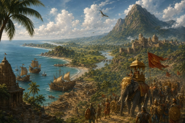
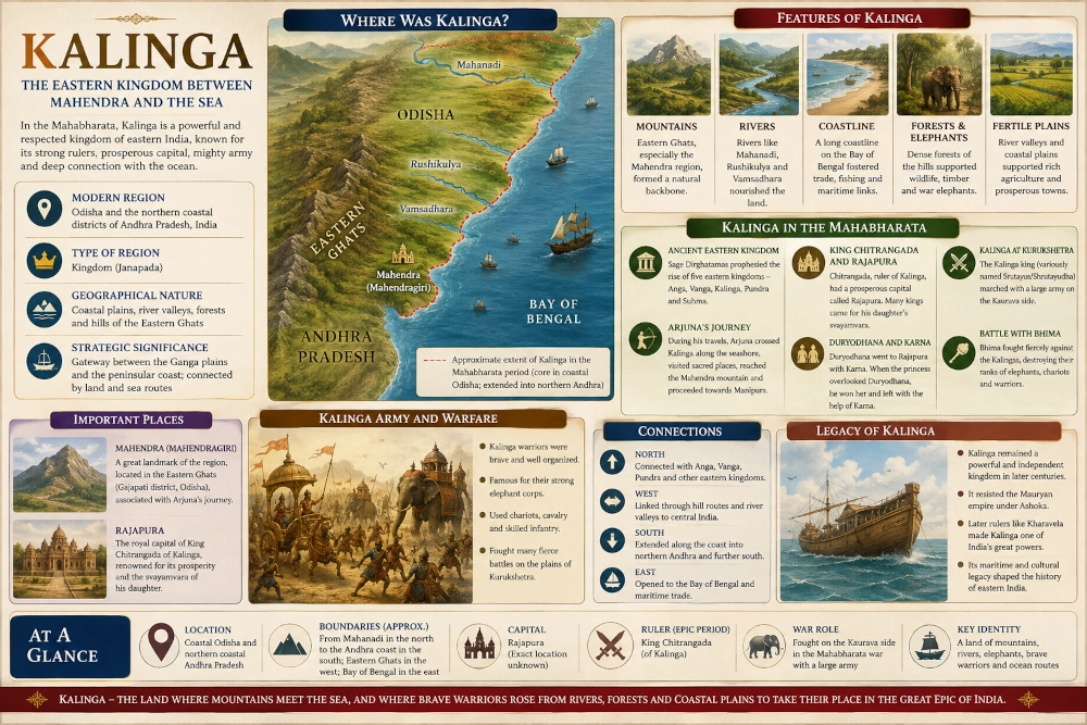
To imagine the Kalinga of the Mahabharata, one must look eastward, towards a land where mountains descend towards the Bay of Bengal, rivers leave the Eastern Ghats and spread across fertile coastal plains, and the sea forms not a distant frontier but one of the defining features of the country. Ancient Kalinga belonged to this remarkable meeting ground of hill, forest, river valley and coast. In modern geographical terms, its heartland can be placed broadly within Odisha, particularly its central and southern coastal regions, with the Kalinga cultural and political zone extending southward into what are now the northern coastal districts of Andhra Pradesh. The precise boundaries changed considerably over time and should not be imagined as fixed modern borders.
The Mahabharata does not treat Kalinga as an obscure territory at the edge of the known world. It repeatedly names the Kalingas among the established peoples and kingdoms of Bharata, places Kalinga within important eastern political networks, describes its rulers participating in great royal gatherings and, eventually, portrays its army fighting with formidable strength on the field of Kurukshetra. Kalinga was therefore part of the epic’s political geography as a recognisable and important eastern realm.
A Kingdom Shaped by Mountain and Ocean
Kalinga’s geography was unusually varied. Along its eastern side stretched the Bay of Bengal. Behind the coast were lagoons, estuaries, river mouths and broad cultivable plains. Farther inland the ground gradually rose towards the forested hills of the Eastern Ghats. Rivers descending through this landscape linked the highlands with the coast and created corridors through which people, agricultural produce, forest products and armies could move.
The southern portion of this landscape is particularly important for understanding the Kalinga of the epic. Here the Eastern Ghats approach the sea more closely. The Rushikulya and Vamsadhara systems drain towards the Bay of Bengal, while beyond them the terrain continues into today’s northern Andhra coast. To the north lay the wider riverine world of Odisha, while to the west rose hill country inhabited by communities whose relationship with the coastal kingdoms must have been both economic and political.
Mahendragiri provides one of the strongest geographical anchors connecting the epic description with this landscape. The mountain today lies in Odisha’s Gajapati district in the Eastern Ghats and rises to about 1,500 metres. Its position close to the Odisha-Andhra region makes it particularly important when reconstructing the southern geography of ancient Kalinga.
This was therefore not simply a kingdom of beaches or a narrow ribbon along the sea. Imagine instead a succession of environments: surf breaking against the eastern coast, broad river valleys covered in cultivated land, belts of woodland alive with elephants and other wildlife, and blue-green ranges rising farther inland. Such geography gave Kalinga access to the resources of both the interior and the sea.
Arjuna’s Journey Reveals the Geography of Kalinga
One of the most revealing descriptions of Kalinga’s location occurs during Arjuna’s travels. The Adi Parva recounts how Arjuna visited sacred waters and holy places in Vanga and Kalinga. His companions eventually left him at the boundary of Kalinga, after which he continued towards the ocean. The narrative then describes him crossing the country of the Kalingas, seeing sacred places along the way, reaching the region of the Mahendra mountain and proceeding towards Manipura along the seashore.
This passage is enormously valuable for Mahabharata geography because it does more than merely name Kalinga. It places the country within an actual journey. Kalinga is associated directly with the ocean, with Mahendra and with a southward coastal route leading towards Manipura.
The description allows the reader to picture Arjuna’s route through an eastern landscape very different from the open plains around Kurukshetra. Here a traveller would have encountered river crossings, humid coastal vegetation, wooded foothills and mountain ridges, while the sea remained a constant presence towards the east. The Mahendra massif would have stood above this landscape as a natural landmark visible across a considerable distance.
Exactly where the Manipura of this particular episode should be located remains debated, and it should not automatically be equated with every later place bearing a similar name. What matters for identifying Kalinga is the route described by the epic itself: Kalinga lay on a major eastern coastal corridor connected with the sea and the Mahendra region.
Kalinga Among the Eastern Kingdoms
The Mahabharata also embeds Kalinga within a much older genealogical conception of eastern India. In the Adi Parva, the sage Dirghatamas tells Queen Sudeshna that she will have sons named Anga, Vanga, Kalinga, Pundra and Suhma, and that countries bearing their names will become known on earth. The account is an epic genealogy rather than modern history, but geographically it is significant because it groups Kalinga with the major countries of eastern India.
The tradition reflects an ancient awareness of a chain of distinct eastern regions stretching from the lower Gangetic world towards the Odisha coast. Anga, Vanga, Pundra, Suhma and Kalinga were not represented as one indistinguishable territory. Each possessed its own name and political identity, while all belonged to a broader eastern geographical sphere.
Kalinga occupied the southern portion of that eastern world. From here the coast continued towards Andhra and the farther south, while routes through the interior connected Kalinga with central India and the Deccan. Its location gave the kingdom considerable strategic importance. An army moving along the eastern seaboard could hardly ignore it, while a ruler controlling its river valleys and coastal approaches could command routes between northern eastern India and peninsular India.
Rajapura — The Royal City of Kalinga
The Shanti Parva gives Kalinga another remarkable appearance through the story of King Chitrangada. Narada tells Yudhishthira that numerous rulers once gathered for the svayamvara of the daughter of Chitrangada, ruler of Kalinga. The king’s capital is specifically named Rajapura, and the text describes it as a prosperous city to which hundreds of rulers came. Duryodhana travelled there accompanied by Karna.
The scene tells us something important about Kalinga’s political stature. A royal marriage held there was capable of attracting rulers such as Shishupala, Jarasandha, Bhishmaka, Rukmi and others from several regions of India. Rajapura was therefore imagined not as a remote provincial settlement but as a royal centre capable of hosting an assembly of powerful kings.
Its exact archaeological identification, however, remains uncertain. Various attempts have been made to connect Rajapura with later cities, including places much farther south, but none should be presented as conclusively established. For a geography article, it is safer to retain Rajapura as the named Kalinga capital of the Mahabharata narrative while acknowledging that its precise modern location remains unresolved. Historical scholarship itself records competing identifications.
The svayamvara ended dramatically. When the princess passed over Duryodhana during the selection, he seized her and departed in his chariot, relying heavily upon Karna’s prowess when the assembled kings gave pursuit. The episode subsequently became part of the celebrated friendship between Karna and Duryodhana. Later traditions commonly identify the Kalinga princess as Bhanumati, although the relevant passage of the Mahabharata simply refers to her as Chitrangada’s daughter.
Kalinga and the Kuru Court
The Rajapura episode also helps explain why Kalinga appears closely associated with the Kaurava side during the Kurukshetra War. Whether every later military relationship should be explained directly through this marriage cannot be proved, but the epic certainly presents contact between Kalinga’s royal house and Duryodhana before the final war.
Such matrimonial alliances were among the strongest tools of ancient diplomacy. A marriage could connect courts separated by hundreds of kilometres, creating obligations that extended into warfare and succession politics. Through Kalinga, the political network surrounding Hastinapura reached far beyond the upper Gangetic plain and deep into eastern coastal India.
This is one of the features that makes the Mahabharata such a valuable geographical text. Its political world is not restricted to Hastinapura, Panchala and Mathura. Kings arrive from Gandhara in the northwest, Pragjyotisha in the northeast, Sindhu, Madra, Kalinga, the Deccan and numerous other regions. Kalinga stands within that vast interconnected system.
The Kalingas at Kurukshetra
When the war finally began, Kalinga emerged as one of the notable contingents fighting for Duryodhana. The Bhishma Parva describes Duryodhana ordering the Kalinga ruler and his large division forward against Bhimasena. What follows is one of Bhima’s most violent battlefield encounters in the epic.
The scene is filled with the imagery of eastern warfare. Chariots advance in formation, horsemen and warriors crowd the field, and elephants loom among the combatants. Bhima finds himself surrounded by a great force and continues fighting even when supporting troops fall away. The battle deteriorates into furious close combat in which bows, arrows, maces, swords, lances and battle-axes are employed.
Different translations and textual traditions render the Kalinga ruler’s name as Srutayus, Shrutayudha or closely related forms, and associated princes are also transmitted with variations. Rather than forcing all versions into a single genealogy, the essential geographical point is clear: the epic remembers the Kalingas as a major organised fighting force under their own ruler. Odisha’s official historical account similarly preserves the tradition of a Kalinga king participating on the Kaurava side.
Bhima’s attack becomes devastating. The Kalinga ranks are broken amid fighting involving infantry, chariots and elephants, and the surviving warriors eventually retreat in disorder. Later in the war, Kalinga warriors again appear opposing Bhima, demonstrating that the contingent was not merely mentioned in passing but was woven into the epic’s description of the Kaurava military coalition.
Elephants and the Eastern Battlefield
The prominence of elephants in the battle imagery suits the ecological landscape associated with eastern India. Forested tracts extended through the hills behind the Odisha coast and into the Eastern Ghats, historically supporting significant elephant populations. The Mahabharata does not allow us to reconstruct an exact Kalinga military establishment, but its descriptions repeatedly associate powerful eastern armies with elephant warfare.
An approaching elephant corps would have been one of the most intimidating sights on an ancient battlefield. Huge animals protected by armour or controlled by trained riders could disrupt infantry formations, attack chariots and create panic among horses. The thundering movement of such animals, mixed with the sound of conches, drums, bowstrings and shouting warriors, gives the Kalinga-Bhima episode much of its extraordinary violence.
For the reader, the episode provides a striking contrast between Kalinga’s peaceful coastal geography and its battlefield identity. The same country of rivers, forests and ocean routes also supplied warriors capable of travelling across the subcontinent to fight on the plains of Kurukshetra.
The Mahendra Mountain and Kalinga’s Southern Frontier
Mahendra deserves special attention because few physical landmarks provide such a vivid connection between the epic world and present geography. Modern Mahendragiri in Gajapati district rises dramatically from the Eastern Ghats close to the Andhra frontier. The surrounding country consists of ridges, forested slopes, valleys and upland plateaus overlooking the lower country towards the coast.
Standing in this region today, one can understand why a mountain such as Mahendra could become a geographical marker in ancient literature. Before precise maps, mountains, major rivers and coastlines were the great reference points of travel. A traveller proceeding south through Kalinga could recognise the Mahendra country long before reaching the mountain itself.
The Mahabharata’s description of Arjuna passing through Kalinga, approaching the ocean, seeing Mahendra and proceeding farther along the seashore is therefore one of the strongest reasons for placing the epic Kalinga firmly within the Odisha-northern Andhra coastal world.
Rivers, Plains and the Interior
Kalinga’s strength came partly from the unusual compression of several ecological zones into one region. Along portions of the coast lay fertile alluvial land capable of sustaining settled agriculture. Rivers descending from the hills carried water and sediment into these plains. Behind them stretched forested uplands rich in timber, animals and other natural products.
Farther north, the geographical system opens into the great Odisha river plains associated with the Mahanadi and other rivers. In the south, the Rushikulya basin passes between the Eastern Ghats and the sea, while the Vamsadhara and neighbouring river systems lead towards the northern Andhra coast. Historical definitions of Kalinga changed according to period and political power, which explains why ancient sources sometimes suggest a relatively compact southern Odisha heartland and at other times use Kalinga for a much broader coastal territory.
This variation is important. Ancient geographical names represented cultural and political landscapes rather than permanently surveyed territories. A powerful Kalinga ruler could extend the name far beyond its earlier core; after political contraction, neighbouring regional names might again become prominent.
A Land Facing the Bay of Bengal
Kalinga would eventually become famous for maritime activity, and its geography explains why. A long coastline, navigable river mouths and access to fertile and forested hinterlands naturally encouraged communication by water. In later historical centuries, the eastern coast developed strong connections with maritime networks across the Bay of Bengal and beyond.
Care is necessary, however, when moving from the Mahabharata to later history. The epic does not give us a detailed account of Kalinga’s overseas commercial system, and later maritime achievements should not simply be projected backwards into the epic age. What the Mahabharata does establish clearly is Kalinga’s intimate relationship with the sea.
This maritime orientation made Kalinga geographically different from many of the kingdoms of the interior. The sea did not close the land off; it opened another horizon. To its west were forest passes and the Indian interior. To its north were other eastern kingdoms. To its south stretched the coastal road into Andhra and farther peninsular India. To its east lay the vast Bay of Bengal.
Kalinga, Utkala and Odisha — Names That Should Not Be Confused
The names Kalinga, Utkala and Odra appear at different times in ancient literature and should not automatically be treated as exact synonyms. The Mahabharata itself names Kalingas and Utkalas separately in geographical enumerations, indicating that ancient authors could distinguish between them.
Over the centuries, political changes caused these names to expand, contract and overlap. Kalinga eventually became so celebrated that later historical memory often used it broadly in association with Odisha. Modern Odisha’s own historical account acknowledges the deep association of the state with ancient Kalinga.
For Mahabharata geography, therefore, the most responsible identification is not to declare that Kalinga equals the whole of modern Odisha. Instead, it should be understood as an eastern coastal kingdom whose principal geographical heartland lay in coastal Odisha, particularly towards its central and southern sectors, and whose sphere extended into northern coastal Andhra Pradesh.
From Epic Kingdom to Historical Power
Kalinga’s story did not end with the world remembered by the Mahabharata. Centuries later it remained sufficiently powerful and independent to confront the Mauryan emperor Ashoka. The Kalinga War of the third century BCE became one of the decisive episodes of Indian history. Odisha’s official historical record describes Kalinga as a powerful kingdom associated with the Mahabharata tradition long before the Mauryan conquest.
Later still, Kharavela would rule from Kalinga and project power across large areas of India. Maritime networks expanded, religious traditions flourished, and the name Kalinga became associated with one of eastern India’s most distinctive civilisational traditions.
Yet those later achievements should be seen as chapters in a long history rather than evidence that the political boundaries of Kalinga remained unchanged. The Kalinga of Ashoka and Kharavela belonged to later historical circumstances. The Kalinga of the Mahabharata represents an earlier remembered landscape—one already sufficiently important to have its own dynasty, royal city, military identity and place within the political world of Bharata.
Kalinga in the Landscape of the Mahabharata
Among the regions described in the Mahabharata, Kalinga is unusually easy to visualise because the epic gives us several complementary clues. It is named among the recognised countries of Bharata. Its legendary ancestry connects it with the eastern kingdoms of Anga, Vanga, Pundra and Suhma. Its king Chitrangada rules from prosperous Rajapura. Duryodhana travels there with Karna. Its warriors later march all the way to Kurukshetra. Most importantly for geography, Arjuna crosses Kalinga while travelling beside the eastern ocean and passes towards Mahendra.
Together these clues reveal a coherent landscape.
Picture dawn spreading across the Bay of Bengal while fishing craft move beyond the surf. Inland, mist hangs over cultivated plains and river channels. Farther west and south, the dark ridges of the Eastern Ghats rise above forests where elephants move beneath the canopy. Roads and pathways follow rivers through the hills, while another route runs along the coast. Somewhere within this country stands the royal city remembered as Rajapura, receiving kings from across India. Beyond it rises Mahendra, one of the great natural landmarks of the eastern seaboard.
This is Kalinga of the Mahabharata: not merely an ancient name for Odisha, but a powerful eastern kingdom formed by the meeting of mountain, forest, river and ocean, positioned between the Gangetic east and the long coastal road leading into peninsular India.
And when the conches of Kurukshetra finally sounded, warriors from this distant shore were there—having crossed hundreds of kilometres from the land beneath Mahendra to take their place in the greatest war remembered by the Indian epic tradition.
You may also like
-
PM Vishwakarma Reaches 30-Lakh Artisan Registration Target as Scheme Completes Three Years
-
Mahishaka in the Mahabharata: The Ancient Southern Country of the Upper Kaveri
-
Vanavasi in the Mahabharata: The Ancient Forest Kingdom of Karnataka
-
Kuntala in the Mahabharata: The Ancient Country of Northern Karnataka and Southern Maharashtra
-
Ashmaka or Assaka in the Mahabharata: The Ancient Kingdom of the Godavari Valley
