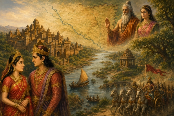
Vidarbha was one of the most important ancient kingdoms of the Deccan and is repeatedly recognised in the Mahabharata as a distinct political and geographical region. Unlike some ancient names whose locations remain highly uncertain, Vidarbha has an unusually strong continuity with the modern landscape. The ancient country can be broadly associated with eastern Maharashtra, particularly the regions around Amravati, Nagpur, Wardha and the adjoining districts, although its boundaries naturally changed over different periods.
The Maharashtra State Gazetteer identifies ancient Vidarbha with the old Berar region together with the eastern districts around Wardha, Nagpur, Chandrapur and Bhandara. It also describes Vidarbha as one of the oldest recorded geographical names associated with Maharashtra.
Within the Mahabharata, Vidarbha is best known through the magnificent story of Nala and Damayanti. Damayanti was the daughter of King Bhima of Vidarbha, and her father’s royal court becomes one of the principal settings of the Nalopakhyana in the Vana Parva. The epic also refers to the city of Kundina, the royal centre of Vidarbha, and later brings Vidarbha directly into the political and military world surrounding the Kurukshetra War.
Vidarbha at a Glance
| Feature | Identification |
|---|---|
| Ancient Name | Vidarbha |
| Political Character | Major kingdom of the eastern Deccan |
| Principal Mahabharata Association | King Bhima and Princess Damayanti |
| Famous Story | Nala and Damayanti |
| Ancient Capital | Kundina or Kundinapura |
| Probable Modern Identification of Kundina | Kaundinyapur near Amravati |
| Approximate Modern Region | Eastern Maharashtra |
| Principal Modern Centres | Amravati, Nagpur, Wardha and adjoining districts |
| Wider Historical Extent | Berar and much of eastern Maharashtra |
| Important Rivers | Wardha, Wainganga and the Payoshni/Purna river system |
| Sacred Association | Sage Agastya and Princess Lopamudra of Vidarbha |
| Krishna Connection | Bhishmaka, Rukmini and Rukmi |
| Rajasuya Connection | Vidarbha-Bhojakata region encountered during Sahadeva’s southern campaign |
| Kurukshetra Connection | Vidarbha troops appear in the Kaurava military formation |
| Modern State | Maharashtra |
| Country Today | India |
Where Was Ancient Vidarbha?
Ancient Vidarbha occupied a large part of what is now eastern Maharashtra. Historical geographical reconstruction generally associates its western portion with the old Berar or Varhad region, covering the Amravati-Akola belt, while its eastern territory extended towards Wardha, Nagpur, Bhandara and Chandrapur. The precise frontier cannot be drawn as a modern administrative boundary because ancient kingdoms expanded, contracted and sometimes overlapped with neighbouring political regions.
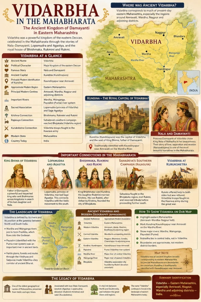
The Maharashtra State Gazetteer describes Vidarbha as comprising present-day Berar together with the eastern districts of Wardha, Chandrapur, Nagpur and Bhandara. This gives Vidarbha one of the strongest modern geographical identifications among the southern kingdoms mentioned in ancient literature.
Vidarbha → eastern Maharashtra → Amravati, Wardha, Nagpur and adjoining districts → India.
This should still be treated as an approximate geographical correspondence rather than an attempt to impose the boundaries of modern Maharashtra districts upon the Mahabharata period.
One of the Oldest Names in Maharashtra
Vidarbha is particularly significant because its name is much older than the modern political identity of Maharashtra. The Maharashtra State Gazetteer describes Vidarbha as perhaps the most ancient geographical place-name associated with the region and notes that it occurs in early Vedic and Upanishadic literature before appearing repeatedly in later Sanskrit traditions.
This long textual history suggests that Vidarbha was already recognised as an established cultural and political region long before many of the later territorial identities of the Deccan emerged. Its continuing survival as the modern regional name Vidarbha represents a remarkable example of geographical continuity across Indian history.
Even today, eastern Maharashtra is conventionally referred to as Vidarbha. The ancient name therefore did not disappear with the kingdoms that once ruled the area but remained attached to the landscape itself.
Kundina: The Royal Capital of Vidarbha
The Mahabharata identifies Kundina, also written Kundinapura, as the royal city of Vidarbha. During the story of Nala and Damayanti, Kundina is the seat of King Bhima and the place to which Damayanti’s children are sent for protection when Nala’s kingdom collapses. Later, King Rituparna of Ayodhya reaches Kundina in the dramatic sequence that eventually leads to the reunion of Nala and Damayanti.
Kundina is commonly associated with Kaundinyapur in present-day Amravati district, near the Wardha River. Maharashtra government material also preserves the tradition that Kundinpur was the ancient capital of Vidarbha, while regional gazetteer material describes Kaundinyapur as an important ancient settlement associated with the Vidarbha tradition.
The identification should nevertheless be presented with appropriate archaeological caution. Kaundinyapur provides the strongest traditional and geographical candidate for Kundina, but ancient literary geography rarely allows the boundaries and urban sites of the epic period to be reconstructed with absolute certainty.
King Bhima of Vidarbha
One of the most important rulers of Vidarbha in the Mahabharata is King Bhima, the father of Damayanti. He should not be confused with Bhimasena, the second of the five Pandavas. The Nalopakhyana portrays the Vidarbha ruler as a powerful and respected king whose daughter became famous throughout the royal world of Bharat.
Damayanti herself identifies her father as the illustrious ruler of the Vidarbhas and describes him as a mighty king who protected his subjects and possessed considerable wealth and royal authority. The narrative therefore presents Vidarbha not as an obscure frontier territory but as a prosperous kingdom with a recognised royal court.
King Bhima’s ability to send messengers and Brahmanas across distant kingdoms in search of Nala and Damayanti further shows the extent of his connections. The story repeatedly links Vidarbha with Chedi, Nishadha, Kosala and Ayodhya, placing the kingdom firmly within the broader political network of ancient Bharat.
Damayanti: The Princess Who Made Vidarbha Famous
The most celebrated Mahabharata figure associated with Vidarbha is undoubtedly Princess Damayanti. Her story with King Nala of Nishadha forms one of the most beautiful narratives embedded within the Vana Parva, where it is told to Yudhishthira during the Pandavas’ exile.
Damayanti was the daughter of King Bhima of Vidarbha. Even before Nala and Damayanti met, wandering swans carried stories of their virtues and beauty between Nishadha and Vidarbha. The birds eventually reached the city of the Vidarbhas and spoke to Damayanti about Nala, beginning the chain of events that would lead to their marriage.
When Damayanti’s swayamvara was announced, rulers and even divine beings sought her hand. She remained devoted to Nala and chose him despite the presence of the gods. Vidarbha consequently becomes the setting for one of the epic’s most powerful treatments of love, loyalty, fate and human perseverance.
Nala and Damayanti
After their marriage, Damayanti left Vidarbha and became queen of Nishadha. Their prosperity was eventually destroyed when Nala lost his kingdom to his brother Pushkara in a disastrous game of dice. Nala and Damayanti then wandered through the wilderness together before circumstances forced them apart.
During their wanderings, Nala described the roads leading through the surrounding country. The passage is extremely valuable for historical geography because it mentions the Vindhya region, the Payasvini or Payoshni river, routes towards Vidarbha and Kosala, and roads leading farther into the southern country.
This description places Vidarbha within a network of roads connecting central India, the Vindhyan region and the Deccan. The kingdom was therefore geographically positioned at an important junction between northern India and the deeper southern territories.
Damayanti Returns to Vidarbha
Following her painful separation from Nala, Damayanti eventually reached the kingdom of Chedi. A Brahmana named Sudeva, who had been sent out by King Bhima to search for his missing daughter, recognised her there and revealed her identity as the princess of Vidarbha.
Damayanti was eventually brought back to her father’s kingdom, where the search for Nala continued. King Bhima dispatched Brahmanas throughout different kingdoms and offered substantial rewards to anyone who could discover the whereabouts of Nala.
The eventual return to Kundina of King Rituparna, whose chariot was secretly driven by Nala in disguise, forms one of the dramatic climaxes of the story. The people informed King Bhima of Rituparna’s arrival, and the sound of the chariot entering Kundina helped Damayanti realise that Nala himself might be nearby.
Vidarbha and the Geography of Nishadha
The Nala-Damayanti story is especially valuable because it helps position Vidarbha in relation to the still-debated kingdom of Nishadha. The Mahabharata distinguishes the two clearly: Nala ruled Nishadha, while Damayanti belonged to Vidarbha.
The directions contained within the narrative indicate that roads connected Nishadha with Vidarbha, Kosala, Avanti and the southern country. They also refer to the Vindhya and related central Indian landscapes, suggesting that Nishadha lay somewhere within the central Indian geographical zone not far from Vidarbha.
Vidarbha is much easier to identify than Nishadha because its name survived and remained associated with eastern Maharashtra. The story therefore gives historians an important geographical anchor from which the surrounding kingdoms of the Nalopakhyana can be considered.
The Payoshni and the Vidarbha Landscape
The ancient Payoshni, sometimes appearing in variant forms such as Payasvini, is one of the important rivers connected with the geography surrounding Vidarbha. Scholars have generally associated the ancient river with the Purna or a related river system of the Berar-Vidarbha region, although precise identifications of ancient river names can remain uncertain.
The Nala narrative mentions the river while describing routes leading towards Vidarbha and the southern country. Older geographical studies of the Mahabharata have also used the Payoshni reference as evidence for placing Vidarbha firmly within the Berar-eastern Maharashtra landscape.
For a modern map, the Wardha, Wainganga and Purna river systems are useful geographical anchors. These rivers help distinguish ancient Vidarbha from the Godavari-Marathwada country farther west and south.
The Wardha and Wainganga River Systems
Much of eastern Vidarbha is shaped by the Wardha and Wainganga rivers, which eventually join to form the Pranhita before reaching the Godavari. These river systems created fertile corridors through the eastern Deccan and provided natural lines of communication between the plateau, forest regions and the Godavari basin.
Kaundinyapur itself lies close to the Wardha River, reinforcing the importance of this river system in reconstructing the ancient Vidarbha landscape. Regional gazetteer material places Kaundinyapur across the Wardha from Dewalwada and preserves traditions linking the surrounding territory with ancient Vidarbha.
Vidarbha’s river geography also helps explain its enduring regional identity. Rather than being defined by one city alone, the kingdom occupied a broad inland landscape bounded and interconnected by river valleys, uplands and forest zones.
Lopamudra and Sage Agastya
Vidarbha’s importance in the Mahabharata extends far beyond the story of Damayanti. The epic also associates the kingdom with Lopamudra, the celebrated wife of Sage Agastya.
Mahabharata tradition identifies Lopamudra as a princess of Vidarbha who married Agastya. The Udyoga Parva explicitly remembers the pairing of “Agastya with the princess of Vidarbha Lopamudra,” while other epic traditions describe the relationship in greater detail.
This association became important in later Indian cultural memory because Agastya was strongly connected with the movement of Vedic and Sanskritic traditions south of the Vindhyas. Vidarbha consequently occupies a symbolic position between northern and southern Bharat, serving as one of the great transitional regions of the Deccan.
Vidarbha as a Gateway to the South
The geographical position of Vidarbha made it particularly important within ancient Bharat. Travellers moving southward from the Ganga-Yamuna plains and central India could approach the Deccan through routes crossing the Vindhyan and Satpura landscapes before entering Vidarbha.
From Vidarbha, routes could continue west towards the upper Godavari country, south towards the deeper Deccan and east towards the forested regions that eventually connect with Chhattisgarh and Odisha. The Nala-Damayanti narrative itself preserves the memory of roads leading between Vidarbha, Kosala, Avanti and the southern country.
The Maharashtra State Gazetteer consequently describes Vidarbha as an important early southern region with longstanding connections to northern India. Its geography helps explain why royal marriages, sage traditions and political contacts repeatedly link Vidarbha with kingdoms far beyond the Deccan.
Bhishmaka, Rukmini and the Vidarbha Royal Tradition
Another important Vidarbha royal house associated with the wider Mahabharata tradition is that of King Bhishmaka, his son Rukmi and his daughter Rukmini. Rukmini became the wife of Krishna, creating a powerful connection between Vidarbha and the Yadavas.
The Mahabharata itself remembers Rukmi as the son of Bhishmaka and describes Kundina as his former city. After being defeated by Krishna, Rukmi did not return to Kundina and instead founded another city called Bhojakata.
The fullest narration of Krishna’s marriage to Rukmini belongs to related epic and Puranic traditions, but the Mahabharata clearly assumes familiarity with the Vidarbha royal family. Vidarbha was therefore connected not only with Nala and Damayanti but also with the political world of Krishna and the Yadavas.
Bhojakata and Rukmi
Bhojakata became an important second political centre connected with the Vidarbha royal family. According to the Udyoga Parva, Rukmi established the city after his defeat by Krishna because he had vowed not to return to Kundina unless he had first defeated Krishna.
The Sabha Parva also mentions Bhojakata during Sahadeva’s southern campaign undertaken before Yudhishthira’s Rajasuya sacrifice. Sahadeva fought in the Bhojakata region and later sent an envoy to Rukmi, who accepted Pandava suzerainty and provided tribute.
The exact modern location of Bhojakata is more uncertain than that of Kundina.
Vidarbha and Sahadeva’s Southern Campaign
Before Yudhishthira could perform the Rajasuya sacrifice, his brothers undertook campaigns in different directions to secure the submission or alliance of rulers throughout Bharat. Sahadeva was assigned the southern regions.
The Sabha Parva describes Sahadeva travelling through Avanti and then approaching Bhojakata, where he encountered the Vidarbha-associated royal sphere. After fighting Bhishmaka and later communicating with Rukmi, he received tribute before continuing farther south towards Surparaka, Dandaka and other territories.
This passage is geographically valuable because it places the Vidarbha-Bhojakata region within a sequence connecting central India with the western and southern Deccan. It confirms that Vidarbha belonged to the political landscape through which Pandava influence extended during the Rajasuya campaigns.
Rukmi Before the Kurukshetra War
Rukmi appears again shortly before the Kurukshetra War in one of the more unusual diplomatic episodes of the Udyoga Parva. He arrived at the Pandava camp with a large force and offered his military assistance to Arjuna.
Arjuna politely rejected the offer, declaring that he did not require Rukmi’s assistance. Rukmi then approached Duryodhana and made essentially the same proposal, but Duryodhana also refused him. As a result, despite commanding substantial forces, Rukmi personally remained outside the great war.
This does not mean that Vidarbha itself was absent from Kurukshetra. The Mahabharata separately refers to Vidarbha troops within the Kaurava army, showing that Rukmi’s personal neutrality did not necessarily determine the allegiance of every Vidarbha ruler or military contingent.
The Vidarbhas at Kurukshetra
The Bhishma Parva provides a direct military reference to the Vidarbhas during the Kurukshetra War. In one description of the Kaurava formation, Drona advances accompanied by forces that include the Kuntalas, Dasharnas, Magadhas and Vidarbhas, along with other contingents.
The geographical catalogue in the Bhishma Parva also names the Vidarbhas among the recognised peoples and provinces of Bharat. They appear alongside Kuntalas, Avantis, Surashtras, Aparantas, Magadhas, Kalingas and numerous other regional communities.
These references are important because they demonstrate that Vidarbha was not known to the epic only through the romantic story of Damayanti. It was also recognised as a political and military territory capable of contributing warriors to the enormous alliance system surrounding Kurukshetra.
Why Rukmi and the Vidarbha Troops Are Not a Contradiction
At first glance, Rukmi’s absence from the battle may appear inconsistent with Vidarbha forces fighting in the Kaurava formation. The apparent contradiction disappears once we remember that ancient regions were not necessarily controlled by a single ruler at every stage represented by the epic.
Different dynasties, branches of royal families or subordinate chiefs could control portions of a larger geographical country. The Mahabharata itself preserves traditions from different narrative contexts and possibly different chronological layers, so one should not assume that every reference to “the Vidarbhas” represents Rukmi’s personal army.
The safest conclusion is that Rukmi himself remained outside the Kurukshetra War after both sides rejected his assistance, while warriors identified as Vidarbhas nevertheless participated in the conflict. This distinction preserves both passages without forcing them into an artificial contradiction.
Ancient Vidarbha and Modern Geography
| Ancient Reference | Approximate Modern Association |
|---|---|
| Vidarbha | Eastern Maharashtra |
| Western Vidarbha | Amravati, Akola, Washim, Buldhana and adjoining region |
| Central Vidarbha | Wardha and surrounding districts |
| Eastern Vidarbha | Nagpur, Bhandara, Gondia, Chandrapur and adjoining territory |
| Kundina/Kundinapura | Traditionally identified with Kaundinyapur near Amravati |
| Payoshni | Usually associated with the Purna/Vidarbha river system |
| Wardha River | Major river of central Vidarbha |
| Wainganga River | Major river of eastern Vidarbha |
| Bhojakata | Vidarbha-associated city founded by Rukmi; precise modern identification uncertain |
| Modern State | Maharashtra |
| Country Today | India |
The table should be read as an approximate geographical guide rather than as a reconstruction of fixed ancient administrative frontiers. Of all these associations, the broad equation of Vidarbha with eastern Maharashtra is the most secure, while the precise limits of the ancient kingdom and the identification of individual cities require greater caution.
Vidarbha’s Place Among the Kingdoms of the Mahabharata
Vidarbha holds an unusually rich place in the Mahabharata because the region participates in several completely different dimensions of the epic. It is a royal kingdom through King Bhima, a setting for one of the world’s great love stories through Damayanti, a sacred-cultural region through Lopamudra and Agastya, a Yadava-linked kingdom through Bhishmaka and Rukmi, and finally a military territory whose warriors appear at Kurukshetra.
Few ancient Indian regions combine such a wide range of associations. The Mahabharata does not treat Vidarbha merely as a name appearing in a geographical list but repeatedly places people from the kingdom within major narratives involving marriage, diplomacy, pilgrimage, warfare and interstate politics.
Its geographical position was equally important. Vidarbha stood between northern and southern India, between the Narmada-Vindhya world and the Godavari Deccan, and between central India and the forested eastern interior.
The Legacy of Vidarbha
The most striking legacy of ancient Vidarbha is that its name still survives almost unchanged. More than two millennia of dynastic change did not erase the regional identity, and eastern Maharashtra continues to be called Vidarbha today.
The landscape around Amravati, Wardha and Nagpur therefore provides one of the strongest examples of continuity between Mahabharata geography and modern India. The literary memory of Kundina, the story of Damayanti, the traditions surrounding Lopamudra and Agastya, and the military references to the Vidarbhas all converge on this eastern Deccan region.
Vidarbha — Eastern Maharashtra, especially Amravati, Nagpur, Wardha and adjoining districts — India.
Unlike many more uncertain epic geographies, Vidarbha can be placed on the modern map with considerable confidence at the regional level. Its exact ancient borders may remain impossible to reconstruct, but the continuity of the name, the literary descriptions and the historical geographical tradition all point strongly towards the great eastern Maharashtra landscape that continues to bear the name Vidarbha today.
Sources and Textual Basis
The principal textual basis for this identification comes from the Mahabharata’s Vana Parva, particularly the Nalopakhyana describing King Bhima, Damayanti, Kundina and the routes connecting Vidarbha with Nishadha, Kosala and the southern country. The Sabha Parva provides evidence from Sahadeva’s southern campaign and the Bhojakata-Vidarbha political sphere, while the Udyoga Parva preserves the account of Rukmi immediately before the Kurukshetra War.
The Bhishma Parva is especially important for confirming Vidarbha as a recognised geographical and military region because it includes the Vidarbhas in its catalogue of peoples and describes Vidarbha contingents advancing within the Kaurava army. Modern geographical identification is supported by the Maharashtra State Gazetteer, which associates ancient Vidarbha with Berar and the eastern Maharashtra districts around Wardha, Nagpur, Chandrapur and Bhandara.
You may also like
-
Abhira in the Mahabharata: The Pastoral People of Western India and the Northern Deccan
-
Nasikya in the Mahabharata World: The Ancient Nashik Region on the Upper Godavari
-
Bharukachchha in the Mahabharata: The Ancient Port of Bharuch at the Mouth of the Narmada
-
Surparaka in the Mahabharata: The Ancient Sacred Port of Nala Sopara on the Konkan Coast
-
Aparanta in the Mahabharata: The Ancient Western Coastal Region of Northern Konkan
