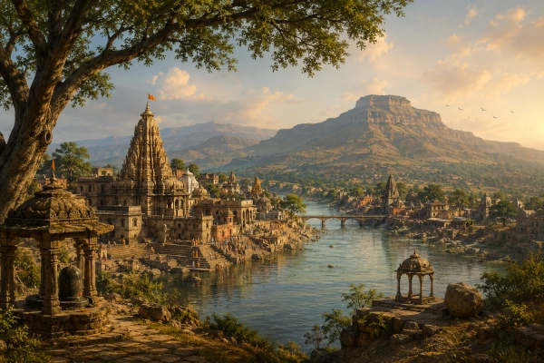
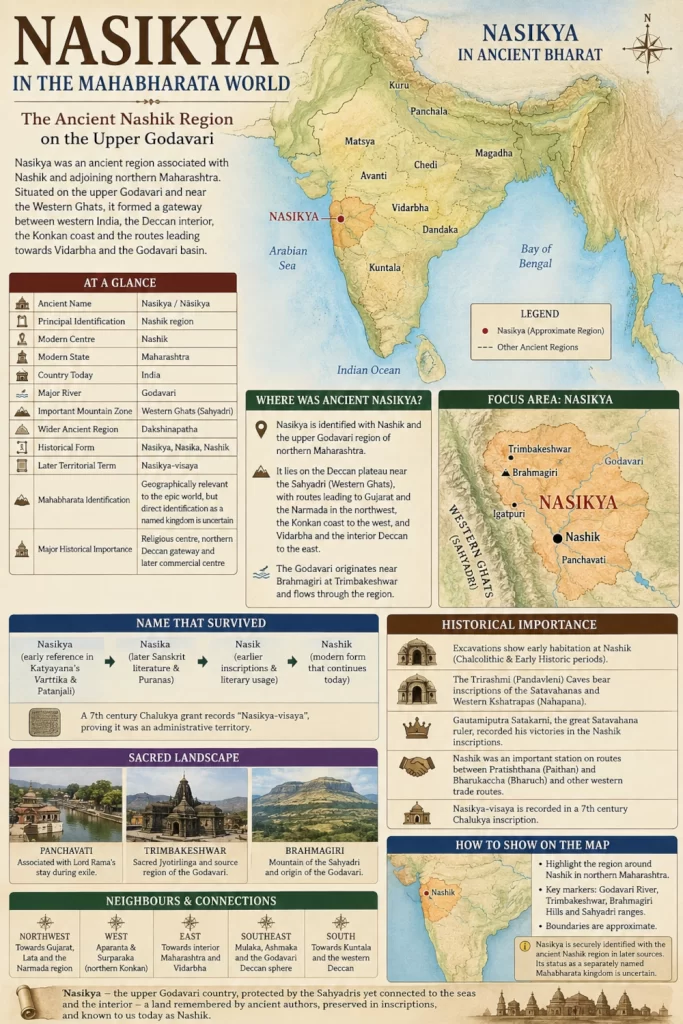
Nasikya was an ancient geographical region associated with present-day Nashik and the adjoining parts of northern Maharashtra. Located along the upper reaches of the Godavari River and close to the eastern slopes of the Western Ghats, the region occupied an important position between western India, the Konkan coast and the interior of the Deccan. Its location near natural mountain passes and river valleys made it a useful gateway for movement between the Arabian Sea coast, Gujarat, central India and the deeper Deccan.
The identification of ancient Nasikya with modern Nashik is strong. Ancient grammatical, geographical and inscriptional sources preserve forms such as Nasikya, Nasika and Nasik, while later records refer to a territorial division known as Nasikya-visaya. Modern Nashik therefore represents an unusually clear example of an ancient Indian geographical name surviving into the present.
Nasikya must nevertheless be treated carefully when reconstructing the political geography of the Mahabharata. Unlike Matsya, Chedi, Magadha, Surasena or Vidarbha, Nasikya is not securely documented in the epic as a major independent kingdom with a clearly identified ruler or army. The Nashik region certainly belonged to the wider geographical world of ancient Bharat, but the evidence for describing Nasikya itself as a distinct Mahabharata kingdom remains uncertain.
Where Was Ancient Nasikya?
Ancient Nasikya can be placed broadly around modern Nashik and the upper Godavari valley of northern Maharashtra. The geographical centre of the region lay around present-day Nashik, Panchavati and Trimbakeshwar, with the Sahyadri ranges forming its western mountain zone.
The Godavari rises near Brahmagiri at Trimbakeshwar, west of Nashik, before flowing eastward across the Deccan. The river gave the Nasikya region fertile valleys, water resources and a natural route towards the interior of peninsular India. To the west, the Sahyadri ranges separated the Nashik plateau from the Konkan coast, while mountain passes allowed movement between the two regions.
To the north-west lay the routes towards southern Gujarat and the lower Narmada region. To the east stretched the interior regions of Maharashtra, eventually leading towards Vidarbha. Farther south and south-east lay territories associated in different periods with Mulaka, Ashmaka and the wider Deccan.
The most useful modern geographical identification is therefore Nasikya — Nashik and adjoining northern Maharashtra, India.
The Ancient Name Nasikya
The name Nasikya has deep roots in Sanskrit literature. Early grammatical traditions preserve Nasikya as the name of a settlement, and later geographical texts place the Nasikyas among the peoples and regions of Dakshinapatha.
Over time, the form of the name appears to have evolved from Nasikya to Nasika and eventually Nasik and Nashik. The continuity is significant because it allows ancient textual references to be linked with a clearly identifiable modern location.
The historical importance of the name becomes even stronger through inscriptional evidence. A seventh-century Chalukya grant records a territorial division known as Nasikya-visaya. The term visaya was commonly used for an administrative district or territorial subdivision. This shows that Nasikya had become more than simply the name of a settlement and was recognised as the name of a wider region.
The sequence from Nasikya to modern Nashik therefore reflects a geographical tradition that survived across many centuries of political change.
Was Nasikya a Mahabharata Kingdom?
This is the area where caution is most necessary.
Modern geographical lists sometimes include Nasikya among the kingdoms of the Mahabharata and identify it directly with modern Nashik. However, the textual evidence for doing so is not as strong as it is for kingdoms such as Matsya, Chedi, Magadha, Avanti, Vidarbha or Surasena.
Different Mahabharata manuscripts preserve varying geographical names, particularly in long lists of peoples and regions. Scholars have therefore warned against automatically reconstructing uncertain or corrupted names as Nasikya without stronger textual support.
This does not mean that the Nashik region was outside the geographical world of the Mahabharata. On the contrary, northern Maharashtra lay between several regions that clearly belonged to the cultural geography of ancient Bharat. The upper Godavari, the western Deccan, the Konkan approaches and the routes towards Vidarbha formed part of the wider landscape known to ancient Indian traditions.
Nasikya is therefore best understood as an ancient regional name that belongs to the broader geographical environment of the Mahabharata rather than as one of the epic’s most securely documented kingdoms.
Nasikya, Panchavati and Janasthana
The Nashik region is far more prominently associated with the Ramayana than with the Mahabharata. Panchavati, located within the modern Nashik area, is traditionally identified as the place where Rama, Sita and Lakshmana lived during part of their exile.
The wider forest country around Panchavati is associated with Janasthana, an important region in the Ramayana narrative. The encounter with Shurpanakha and the events leading towards the abduction of Sita are traditionally connected with this landscape.
Nasikya, Panchavati and Janasthana should not be treated as identical terms. Panchavati represents a sacred settlement within the Ramayana tradition, while Janasthana refers to the wider forest region associated with the narrative. Nasikya appears more clearly as an urban and regional geographical name in later ancient sources.
Over time, however, these traditions became connected with the same broad landscape around Nashik and the upper Godavari.
Nasikya Within Dakshinapatha
Ancient geographical traditions placed Nasikya within Dakshinapatha, the great southern geographical division of Bharat. Dakshinapatha did not refer only to the extreme south of India. In many ancient sources, it broadly included the territories south of the Vindhyan and Narmada regions and extended across much of the Deccan.
Nasikya’s position fits this geographical framework extremely well. Nashik lies near the northern edge of the Deccan, just south of the great geographical transition between central India and peninsular India.
The region therefore functioned as one of the natural northern gateways into Dakshinapatha. Travellers approaching from Gujarat, Malwa or the Narmada corridor could move through this region before continuing deeper into Maharashtra and the Godavari basin.
Later geographical traditions place Nasikya alongside other regions such as Maharashtra, Vidarbha, Ashmaka, Kuntala, Surparaka and Konkana. This confirms its place within the wider geographical system of the western and northern Deccan.
The Godavari and the Landscape of Nasikya
The Godavari is the defining geographical feature of Nasikya. Rising near Brahmagiri at Trimbakeshwar, the river passes through the Nashik region before beginning its long journey eastward across peninsular India.
The upper Godavari provided water, agricultural land and a natural corridor through the Deccan plateau. Settlements that developed along the river could connect with regions farther east while remaining close to the Sahyadri mountain passes leading towards the western coast.
The river also became one of the great sacred waterways of India. Trimbakeshwar and Nashik grew into major pilgrimage centres, and the Godavari became inseparable from the religious identity of the region.
For any geographical reconstruction of Nasikya, the Godavari should therefore be treated as the principal natural landmark.
Brahmagiri and the Sahyadri
West of Nashik rises Brahmagiri, part of the Sahyadri or Western Ghats. The Godavari originates in this mountain zone near Trimbakeshwar.
The Sahyadri ranges formed a dramatic western boundary for the Nasikya region. Beyond them lay the lower and more humid Konkan coast and the Arabian Sea.
The presence of mountain passes made the Nashik region especially important. Although Nasikya belonged geographically to the Deccan plateau, it remained closely connected with the coast through routes crossing the Western Ghats.
This gave Nasikya access to two distinct geographical worlds. To the east lay the vast interior of the Deccan, while to the west lay the ports and coastal settlements of Aparanta and Surparaka.
Nasikya as a Gateway Between the Coast and the Deccan
The later commercial importance of Nashik demonstrates how valuable this geographical position became.
Nashik stood on routes connecting the Deccan interior with the western coast and with commercial centres farther north. During the Early Historic period, routes linked the Nashik region with Pratishthana, present-day Paithan, and with Bharukachchha, modern Bharuch, one of the most important ports of western India.
Other routes descended through the Western Ghats towards the northern Konkan and the Arabian Sea.
These documented trade networks belong mainly to the centuries after the period traditionally associated with the Mahabharata. They should not simply be projected backwards unchanged into the epic age.
However, the underlying physical geography was much older. The rivers, mountain passes and plateau corridors that made historical Nashik important would also have influenced movement through the region in earlier centuries.
Nasikya and Its Neighbouring Ancient Regions
Nasikya occupied a strategic position among several ancient regions of western and central India.
To the west and south-west lay Aparanta and Surparaka, representing the northern Konkan and the coastal routes towards the Arabian Sea. To the north-west lay the approaches towards Lata and Bharukachchha in southern Gujarat and the lower Narmada region.
Farther east lay the broader territories of interior Maharashtra and Vidarbha. Towards the south-east stretched the Godavari-Deccan regions associated in different periods with Mulaka and Ashmaka. Farther south lay the territories that would later be associated with Kuntala and the western Deccan.
Ancient political boundaries changed frequently and should not be mapped as if they corresponded exactly to modern district or state borders. Nasikya is therefore best represented as a broad geographical zone centred on Nashik rather than as a sharply bounded political territory.
Nasikya and Surparaka
The relationship between Nasikya and Surparaka is particularly useful for understanding the geography of western India.
Surparaka is identified with the Sopara region of the northern Konkan, near modern Nala Sopara. Nasikya lay inland on the Deccan plateau beyond the Western Ghats.
The two regions therefore stood on opposite sides of one of western India’s most important geographical transitions. Surparaka belonged to the coastal world of the Arabian Sea, while Nasikya belonged to the plateau and upper Godavari country.
Mountain passes through the Sahyadris connected these regions, allowing goods, people and ideas to move between the coast and the Deccan interior.
Nasikya and Vidarbha
Nasikya should also be distinguished clearly from Vidarbha.
Vidarbha occupied the eastern part of present-day Maharashtra and was one of the most important political and cultural regions of the ancient Deccan. Nasikya, by contrast, belonged to northern-western Maharashtra around the upper Godavari and the Sahyadri ranges.
The distance between the two illustrates an important feature of ancient Maharashtra. The modern state contained several distinct historical regions rather than one single political entity.
Nasikya, Surparaka, Aparanta, Mulaka, Ashmaka, Vidarbha and Kuntala all belonged to different geographical traditions and developed their own political identities at different times.
The Rise of Historical Nashik
The evidence for Nashik becomes much stronger during the Early Historic period.
Archaeological remains show that the region was inhabited long before the emergence of the great historical dynasties of the western Deccan. Over time, Nashik developed into an important settlement positioned along commercial and political routes.
By the Satavahana period, the region had become a major centre of trade, religion and administration. Its location between the Deccan interior and the western coast attracted merchants, rulers, monks and travellers.
The importance of ancient Nashik is particularly visible in the caves and inscriptions of the Trirashmi hills.
The Trirashmi or Nashik Caves
The rock-cut monuments known as the Nashik Caves or Pandavleni are among the most important archaeological remains of the region.
Despite the popular name Pandavleni, the surviving caves are primarily Buddhist monuments belonging to the Early Historic period. Their inscriptions preserve the names of rulers, merchants and donors connected with several major political powers.
The Satavahanas patronised the site, while inscriptions associated with the Western Kshatrapa ruler Nahapana and his family also survive there. Later, the Satavahana ruler Gautamiputra Satakarni defeated the Kshaharata power and restored Satavahana influence across parts of western India.
The caves therefore reveal Nashik as a region of considerable political and economic importance.
Gautamiputra Satakarni and Nashik
Gautamiputra Satakarni, one of the greatest rulers of the Satavahana dynasty, is closely connected with Nashik through inscriptional evidence.
An inscription composed by his mother, Gautami Balashri, celebrates his achievements and victories over rival powers. His defeat of the Kshaharatas helped restore Satavahana control over important western territories and trade routes.
Nashik stood within this strategic zone. Control over the region meant access to routes connecting the Deccan with the western coast and with major commercial centres farther north.
The political struggles of the Satavahana period therefore demonstrate the enduring strategic importance of the Nasikya landscape.
Nasikya-Visaya and the Survival of the Regional Name
The survival of Nasikya as a territorial name becomes especially clear in the early medieval period.
A seventh-century Chalukya inscription records a village situated within Nasikya-visaya. The term confirms that Nasikya had become the recognised name of an administrative region.
This is one of the strongest pieces of evidence demonstrating geographical continuity between ancient Nasikya and later Nashik.
Political dynasties changed, but the regional name survived.
Nasikya and Modern Geography
Ancient Nasikya corresponds most closely with the region around modern Nashik, Trimbakeshwar and the upper Godavari valley.
Nashik should be shown as the principal modern reference point. Trimbakeshwar and Brahmagiri mark the western sacred and geographical edge of the region, while Panchavati represents the important Ramayana-associated landscape within modern Nashik.
The Sahyadri ranges should form the major western geographical feature, while the Godavari should be shown flowing eastward across the highlighted territory.
The wider highlighted area can extend into adjoining northern Maharashtra, but it should not be drawn so broadly that it absorbs clearly distinct ancient regions.
Nasikya’s Place in the Mahabharata World
Nasikya occupies a different position in Mahabharata geography from kingdoms such as Matsya, Chedi, Magadha or Vidarbha.
There is no securely identifiable Nasikya ruler who plays a major role in the epic, nor is there strong evidence for an independently named Nasikya army at Kurukshetra.
Its importance lies primarily in geography.
The Nashik region stood between several major cultural zones of ancient India. It connected the western coast with the Deccan interior and lay close to the routes leading towards Gujarat, the Narmada valley and Vidarbha.
The upper Godavari, the Sahyadri passes and the plateau routes made this region an important part of the wider geographical landscape of ancient Bharat.
Nasikya therefore helps us understand not only political geography but also the routes and natural corridors that linked the kingdoms and peoples of the epic world.
From Sacred Landscape to Historical Centre
The history of Nasikya demonstrates how a single region could acquire several overlapping identities across different periods.
In sacred tradition, the Nashik landscape is closely associated with Rama, Sita, Lakshmana, Panchavati and the upper Godavari.
In ancient geographical literature, the region appears as Nasikya within Dakshinapatha.
In archaeological history, Nashik emerges as an important Early Historic settlement with major Buddhist rock-cut monuments.
Under the Satavahanas and Western Kshatrapas, it became an important commercial and political centre.
In early medieval inscriptions, it appears as the administrative territory of Nasikya-visaya.
Modern Nashik continues to preserve all these historical layers.
The Legacy of Nasikya
Nasikya deserves an important place in the geographical reconstruction of ancient Bharat because the continuity between the ancient region and modern Nashik is unusually strong.
The ancient name survives in recognisable form. The Godavari still flows through the same landscape. Brahmagiri and the Sahyadri ranges remain its defining western features. Panchavati and Trimbakeshwar continue to preserve the sacred identity of the region, while archaeological remains demonstrate the antiquity and prosperity of historical Nashik.
At the same time, Nasikya illustrates why ancient geography must be reconstructed carefully. A place that is securely documented in later Sanskrit and inscriptional sources should not automatically be described as a major Mahabharata kingdom unless the epic evidence itself supports that conclusion.
The strongest and most accurate identification is therefore geographical rather than political.
Nasikya was the ancient upper Godavari country around Nashik, positioned between the Sahyadri mountains and the northern Deccan interior. It stood close to routes leading towards the Konkan coast, Gujarat, the Narmada region and Vidarbha.
Ancient authors remembered the region as Nasikya. Later inscriptions preserved the same name. Modern India knows it as Nashik.
Nasikya — Nashik and adjoining northern Maharashtra, India.
You may also like
-
Shaka in the Mahabharata: Central Asia’s Steppe Peoples, Nakula’s Campaign and the Alliance with Duryodhana
-
Yavana in the Mahabharata: Greek Connections, Pandava Campaigns and the Warriors of Kurukshetra
-
India and Sri Lanka Launch SAMHiTA Manuscript Digitisation Project to Preserve Ancient Buddhist Heritage
-
ASI Uses Ground-Penetrating Radar to Investigate Ancient Buddhist Stupa at Ujjain After Nearly 90 Years
-
Pahlava: The Parthian World Beyond India’s Northwestern Frontiers in the Mahabharata
