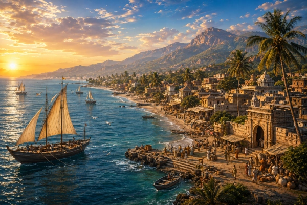
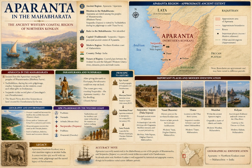
The ancient Aparanta or Aparānta occupied an important place in the western geography of the Mahabharata. In its most specific historical sense, the name is generally identified with the northern Konkan coast of present-day Maharashtra, particularly the coastal territory around modern Palghar, Thane, Mumbai and northern Raigad. The Arabian Sea formed its western edge, while the Sahyadri or Western Ghats separated the narrow coastal plain from the inland Deccan plateau.
The Mahabharata directly names the Aparantas among the peoples of Bharatavarsha. Even more significantly, the epic repeatedly brings the Pandavas into the sacred coastal landscape associated with Surparaka or Shurparaka, generally identified with modern Sopara or Nala Sopara north of Mumbai. In the Shanti Parva, Surparaka is linked with Parashurama and the legendary creation of land along the western sea, while later geographical traditions explicitly identify Surparaka with Aparanta.
Aparanta therefore represents more than a distant coastal name in the Mahabharata. It connects the epic with the ancient maritime world of the Konkan, with the pilgrimage of Yudhishthira, with the traditions of Parashurama and with one of western India’s oldest known ports.
Aparanta at a Glance
Aparanta was an ancient western coastal region whose name literally conveys the idea of the western extremity or western borderland. Ancient texts sometimes use the term broadly for western India, which means its boundaries varied according to period and context. In its narrower and most useful geographical sense, however, historical scholarship identifies Aparanta with northern Konkan, with Surparaka or Sopara as its principal ancient centre. The Maharashtra State Gazetteers similarly identify Aparanta as the historical name of North Konkan.
Its approximate modern identification can therefore be expressed as Aparanta → Northern Konkan coast → Maharashtra → India. The region lay between the Arabian Sea and the Western Ghats and occupied the maritime corridor leading southward from Gujarat toward the wider Konkan coast.
No single ruler of Aparanta dominates the central Mahabharata narrative, and the epic does not provide a detailed dynastic history comparable with Chedi, Matsya or Magadha. Its importance in the epic is primarily geographical and sacred.
Aparanta Is Directly Named in the Mahabharata
The strongest textual evidence appears in the Bhishma Parva, where Sanjaya describes the many peoples and regions of Bharatavarsha to Dhritarashtra. In this geographical catalogue, the Aparantas are explicitly included among the communities inhabiting the wider subcontinent. A modern translation of the relevant passage places the Aparantas alongside Surashtras, Kekayas, Kakshas and other peoples.
The reference demonstrates that Aparanta was already part of the geographical vocabulary preserved in the Mahabharata. The epic does not merely know places around the Gangetic heartland of Hastinapura and Indraprastha. It remembers communities extending to the western seaboard and other distant margins of Bharatavarsha.
Historical geographers have long noted that Aparanta can be interpreted in two ways. In the broadest sense, it can mean the peoples of India’s western regions generally. In a more specific political and geographical sense, the ancient Aparanta country is identified with Northern Konkan and the region centred on Surparaka.
Where Was Ancient Aparanta?
Northern Konkan forms a narrow coastal belt between the Arabian Sea and the steep escarpment of the Western Ghats. The modern landscape includes the coastal territories around Palghar, Vasai-Virar, Thane, Mumbai and adjoining northern Raigad.
Ancient boundaries were not fixed like modern district borders, and the term Aparanta could be applied more broadly in different texts. Some ancient and later traditions extended the idea of Aparanta over much larger portions of western India. However, the official Maharashtra cultural gazetteer describes the historical nomenclature of North Konkan as Aparanta, while archaeological scholarship similarly identifies Aparantaka with northern Konkan and Sopara as its principal centre.
This narrow geographical identification is the most useful for reconstructing the Mahabharata landscape. It places Aparanta immediately south of the Gujarat coast and along the maritime corridor leading from the Gulf of Khambhat toward the Konkan.
A Region Between the Sahyadris and the Arabian Sea
The geography of Aparanta was fundamentally different from the great inland kingdoms of northern India. The region consisted of a relatively narrow strip of coastal plains, river valleys, estuaries, creeks and forested hills compressed between the Arabian Sea and the Sahyadri mountains.
This physical geography shaped everything from settlement to trade. Numerous rivers descend rapidly from the Western Ghats before entering the Arabian Sea, creating estuaries that could support coastal settlements and ports. The Vaitarna and Ulhas river systems are particularly important modern landmarks within the northern Konkan landscape.
The Sahyadris formed a formidable eastern barrier, yet mountain passes connected the coast with the Deccan plateau. These routes allowed ports on the Arabian Sea to communicate with inland centres, turning Aparanta into an interface between maritime commerce and the interior of India.
UNESCO’s description of the wider Konkan landscape emphasises exactly this relationship between western coastal ports and communication corridors crossing the Western Ghats.
Surparaka: The Great Ancient Centre of Aparanta
The most important ancient place associated with Aparanta is Surparaka, Shurparaka or Suparaka, generally identified with modern Sopara or Nala Sopara in Maharashtra’s Palghar district, north of Mumbai.
Archaeological Survey of India scholarship describes Sopara as the ancient Surparaka of Aparanta, or Northern Konkan. It was an important ancient emporium, and fragments of Ashoka’s Eighth and Ninth Rock Edicts were discovered there, confirming the settlement’s considerable importance by the Mauryan period.
Later historical scholarship frequently describes Surparaka as the capital or principal centre of Aparanta. The Mahabharata itself does not explicitly present a statement equivalent to “Surparaka was the capital of Aparanta,” so the distinction should be maintained. It is safest to call Surparaka the principal ancient centre traditionally associated with Aparanta, while noting that later geographical reconstructions treat it as the region’s capital.
The Pandavas Reach Surparaka
Surparaka is not merely a later historical port projected onto epic geography. It appears directly in the Vana Parva of the Mahabharata.
During the Pandavas’ long pilgrimage in exile, Yudhishthira and his companions travel through sacred places along the western sea. The narrative describes them visiting numerous coastal tirthas before arriving at the particularly sacred place called Suparaka. From there they encounter a forest associated with ancient sacrifices and the altar connected with Parashurama.
Another pilgrimage passage instructs the traveller to proceed to Surparaka, where Jamadagni’s son had formerly dwelt, and says that bathing at this sacred place of Rama granted great religious merit.
These references provide a direct connection between the Mahabharata narrative and the northern Konkan coast.
Yudhishthira on the Western Coast
The Vana Parva’s description of Yudhishthira’s pilgrimage is particularly valuable because it presents the western coast as a connected sacred landscape rather than an isolated destination.
The Pandavas move through coastal tirthas, bathe in sacred waters and make gifts before reaching Suparaka. The narrative specifically describes Yudhishthira giving away cattle at sacred places on the coast of the sea before arriving at the celebrated western tirtha.
This establishes the maritime character of the setting. Aparanta belonged to the world of the western ocean, where pilgrimage routes followed a coastline already recognised for sacred places and ancient settlements.
The journey also demonstrates that the Mahabharata’s sacred geography linked northern India with locations deep along the western seaboard.
Parashurama and the Creation of the Western Land
The figure most deeply associated with the sacred geography of Aparanta is Parashurama, the warrior-sage and son of Jamadagni.
The Shanti Parva recounts that after Parashurama had destroyed generations of Kshatriyas and given the conquered earth to Kashyapa, he could no longer continue living on the land he had donated. He therefore withdrew toward the sea. The ocean then made space for him, creating the region known as Surparaka. The textual tradition explicitly associates this Surparaka land with Aparanta.
The narrative became the foundation for the much wider later tradition that Parashurama caused the Arabian Sea to retreat and thereby created the Konkan coast.
Historical Maharashtra gazetteers preserve versions of this tradition in which Parashurama causes the western ocean to recede from the Sahyadri range, producing the country of Shurparaka.
Aparanta and Parashurama-Kshetra
The Parashurama story eventually became one of the defining sacred traditions of the entire Konkan.
Later traditions extended the land reclaimed by Parashurama far beyond the immediate Sopara region. Different versions connect him with Maharashtra, Goa and parts of the Karnataka and Kerala coasts. This later Parashurama-kshetra should not be treated as a precise Mahabharata political boundary.
What the Mahabharata establishes securely is the association between Parashurama, Surparaka and the western coastal land. The epic’s pilgrimage passages remember Surparaka as a tirtha connected with Jamadagni’s son, while the Shanti Parva provides the narrative of land being created for him by the sea.
This makes Aparanta one of the Mahabharata regions where mythology and physical geography are unusually closely intertwined.
What Does Aparanta Mean?
The Sanskrit name Aparānta is formed from ideas associated with the west and the extremity or boundary. It can therefore be understood broadly as the western end, western frontier or western borderland.
This helps explain why the geographical use of the word is not always consistent. Some texts employ Aparanta broadly for western India, while others use it for a more clearly defined territory.
Historical scholarship consequently distinguishes between the general geographical meaning of western regions and the narrower political identification with North Konkan. The latter became particularly strong because Surparaka repeatedly appears as the major centre associated with the region.
This flexibility should be remembered when reconstructing ancient maps. Aparanta cannot always be treated as though it possessed a single permanent frontier over many centuries.
Northern Konkan as the Core Aparanta Region
Despite the wider uses of the term, the identification of Aparanta with Northern Konkan is strongly supported by later historical and epigraphic scholarship.
An Epigraphia Indica discussion explicitly describes Aparanta as a country on India’s western coast corresponding to Northern Konkan, with Sopara or ancient Surparaka as its capital.
The Maharashtra State Gazetteers likewise state that the historical nomenclature of North Konkan was Aparanta.
For a modern geographical reconstruction, the region should therefore be centred on the coastal belt north and immediately south of present-day Mumbai, extending through the Thane-Vasai-Sopara landscape and adjoining coastal districts.
Sopara and the Evidence of Ashoka
The importance of ancient Sopara becomes particularly clear several centuries after the period represented by the Mahabharata traditions.
Fragments of Ashoka’s Rock Edicts VIII and IX were discovered at Sopara during the nineteenth century. Archaeological Survey of India scholarship treats these discoveries as evidence of the settlement’s importance during the Mauryan period.
Aparanta also appears in discussions of Ashoka’s western territories and in later Buddhist traditions describing the spread of Buddhism after the Third Buddhist Council.
This historical material belongs to the third century BCE and later. It cannot be used directly to date Mahabharata events, but it demonstrates that the coastal region associated with the epic’s Surparaka became an established political and commercial centre in the early historical period.
Buddhism Reaches Aparanta
Buddhist tradition gives Aparanta another important role.
The Dipavamsa and Mahavamsa state that the missionary Yonaka Dhammarakkhita was sent to Aparantaka following the Third Buddhist Council during the Mauryan period. Historical and archaeological studies connect this missionary activity with the western coastal region centred on Sopara.
The tradition demonstrates Aparanta’s position within the expanding cultural networks of ancient India. A region that appears in the Mahabharata’s geographical catalogue and sacred pilgrimage routes later became an important centre for Buddhist activity and maritime exchange.
Sopara’s archaeological remains, inscriptions and connections with Buddhist sites elsewhere in western India reinforce this picture.
From Aparanta to the Satavahanas
Aparanta also became important within the political world of the Satavahanas.
The famous Nashik inscription associated with Gautamiputra Satakarni includes Aparanta among the regions connected with his authority, alongside other western and central Indian territories such as Saurashtra, Anupa, Vidarbha, Akara and Avanti.
The reference belongs to the early centuries CE and therefore represents a much later historical phase than the Mahabharata narrative. Nevertheless, it shows that Aparanta had developed into a recognised political region within western India’s imperial geography.
The territory later passed through the influence of Western Kshatrapas and other dynasties, illustrating the strategic importance of controlling the northern Konkan coastline.
Why Aparanta Was Strategically Important
The importance of Aparanta came largely from geography.
To the west lay the Arabian Sea, opening maritime routes toward Gujarat, Sindh, Arabia and eventually the wider Indian Ocean. To the east rose the Western Ghats, but mountain passes provided routes toward the Deccan plateau.
A coastal ruler who controlled Aparanta could therefore influence both overseas commerce and inland movement.
Northern Konkan possessed several natural harbours and estuaries. Ancient and classical sources later record ports including Surparaka/Sopara and Kalyan, while the broader Konkan coast became densely connected with maritime trade. Maharashtra’s historical gazetteers note the importance of several western coastal commercial centres and their connections with overseas markets.
The strategic value of this coastline continued for centuries, long after the ancient name Aparanta gradually fell from common use.
Aparanta and the Sahyadri Passes
The Western Ghats did not simply isolate Aparanta from inland Maharashtra. They also concentrated movement into identifiable passes.
Routes climbing from Konkan toward the Deccan connected the coast with important inland regions. In later periods, ports such as Kalyan became gateways for goods moving between the Arabian Sea and the plateau.
UNESCO’s assessment of the Konkan landscape emphasises that coastal trade was connected with the Western Ghats through major communication corridors.
The same fundamental geography would have influenced earlier periods. Mountain, forest, coast and sea were not separate environments; they formed a connected system through which communities, pilgrims and goods could move.
Aparanta and Saurashtra
North of Aparanta lay the wider coastal world of southern Gujarat, while farther north-west the Kathiawar Peninsula formed the region of Saurashtra.
The Mahabharata names Saurashtra independently, indicating that Aparanta and Saurashtra should not be merged into a single kingdom. The two regions nevertheless belonged to the same broad western maritime corridor.
Travel along the coast could link Aparanta with the Narmada estuary, Bharuch, Saurashtra, Prabhasa and Dvaraka. The Pandavas’ pilgrimage traditions similarly place Surparaka within a much wider sequence of sacred locations extending along western India.
Aparanta therefore served as a geographical bridge between the Konkan coast and the ancient regions of Gujarat.
Aparanta and Lata
The relationship between Aparanta and Lata requires chronological caution.
Lata became a well-attested ancient historical name for southern Gujarat, particularly the Narmada-Tapi region. Aparanta, by contrast, could refer more broadly to western coastal lands but in its narrower usage became strongly associated with North Konkan.
The boundary between these regional labels changed over time. Historical sources from different centuries do not always use them in exactly the same way.
For practical geographical reconstruction, Lata can be shown north of Aparanta, centred around southern Gujarat and Bharuch, while Aparanta occupies the coastal belt farther south around Sopara and northern Konkan. The transition should remain approximate rather than appearing as a precise modern border.
Aparanta and the Deccan Interior
East of the Sahyadris lay the interior plateau generally associated in later history with Maharashtra and the Deccan.
The contrast between these landscapes was significant. Aparanta was maritime, humid and heavily influenced by the monsoon, while the plateau immediately east of the Ghats possessed a different climate and agricultural environment.
Yet the two regions depended upon each other economically. Coastal ports required access to inland commodities, while inland kingdoms benefited from Arabian Sea trade.
The passes through the Western Ghats therefore made Aparanta an important western gateway to the Deccan.
Was Mumbai Part of Ancient Aparanta?
Modern Mumbai lies within the broad geographical zone historically associated with North Konkan and therefore within the later reconstruction of Aparanta.
However, ancient Mumbai did not possess the geographical form seen today. Before extensive land reclamation, the modern metropolis consisted of several islands and tidal landscapes. It would therefore be incorrect to treat present-day Mumbai as the political centre of Mahabharata Aparanta.
For understanding the ancient region, Sopara is much more important because it possesses direct archaeological evidence of major early historic activity and is associated with the ancient Surparaka remembered in textual traditions.
Mumbai remains useful as a modern geographical marker that helps readers locate the region.
Kalyan and the Inland Trade Routes
Modern Kalyan, situated near the Ulhas River system east of Mumbai, became another significant port and trade centre during historical periods.
Classical descriptions of India’s western coast mention Kalliena, generally identified with Kalyan, as a known harbour connected with maritime commerce. Historical gazetteer studies place it among the important ports of the Konkan trading system.
Kalyan’s position illustrates how deeply navigable creeks and river mouths allowed maritime trade to penetrate the coastal interior.
Like Mumbai, however, Kalyan should be treated as a historical and modern geographical reference rather than as a securely identified Mahabharata city.
The Vaitarna and Ulhas River Systems
Northern Konkan is crossed by a series of short west-flowing rivers descending from the Sahyadris. Among the most useful modern geographical markers are the Vaitarna River north of Mumbai and the Ulhas River flowing through the Thane-Kalyan region.
These rivers created fertile valleys, estuaries and natural routes between the mountains and coast. Their mouths and creek systems helped shape the settlement pattern of northern Konkan.
Ancient regional boundaries cannot be reconstructed directly from these rivers, but they provide useful physical anchors for understanding the landscape in which Surparaka and other coastal settlements developed.
The rivers should therefore be seen as part of the environmental setting of Aparanta rather than rigid political frontiers.
The Sea Was Central to Aparanta’s Identity
Few regions in the Mahabharata geographical series are as clearly defined by the sea as Aparanta.
The very position of the region along the western extremity of India made the Arabian Sea part of its cultural identity. The Pandavas’ pilgrimage account describes movement through sacred places along the coast before reaching Surparaka, emphasising that the western ocean formed part of the narrative landscape.
Later history confirms the maritime importance of the same coast. Sopara became an international emporium, and numerous other ports developed along Konkan.
The landscape therefore connects the religious geography of the Mahabharata with the maritime history of ancient western India.
No Secure Mahabharata Ruler of Aparanta
Although the Mahabharata names the Aparantas, it does not give the region the kind of royal narrative associated with Matsya, Chedi, Magadha or Saurashtra.
No individual can confidently be identified as the principal Mahabharata-era king of Aparanta from the passages that establish the region geographically.
This distinction is important. Later rulers certainly controlled Aparanta, including Mauryan officials, Satavahanas, Western Kshatrapas and other dynasties. Their existence does not justify projecting one of them backward into the epic.
A historically careful account should therefore describe the Mahabharata ruler as not securely identified.
Surparaka as the Principal Ancient Centre
The question of the capital requires slightly more nuance.
Historical and epigraphic scholarship frequently identifies Surparaka or Sopara as the capital of Aparanta, and this association is well established for the early historical region.
The Mahabharata itself, however, presents Surparaka primarily as a sacred tirtha associated with Parashurama, not through a detailed account of its political administration.
For this reason, Surparaka can confidently be described as the principal ancient centre of Aparanta and its traditional historical capital, while avoiding the stronger claim that the epic itself explicitly calls it the capital.
Ancient Aparanta and Modern Geography
The core Aparanta landscape corresponds broadly with today’s Northern Konkan region of Maharashtra.
Modern geographical reference points include Nala Sopara, Vasai, Thane, Mumbai and Kalyan, with the Sahyadri or Western Ghats forming the eastern geographical wall and the Arabian Sea lying to the west.
Nala Sopara is especially important because it preserves the location of ancient Surparaka. Mumbai provides the most familiar modern reference point, while Thane and Kalyan help define the inland creek and trade corridor.
The modern identification should therefore be understood as an approximate geographical correspondence rather than a claim that ancient political boundaries followed modern districts.
Surparaka and Modern Nala Sopara
Modern Nala Sopara has been absorbed into the enormous urban region north of Mumbai, making it difficult to imagine the place as one of ancient western India’s major coastal centres.
Yet archaeological evidence demonstrates its antiquity.
The Archaeological Survey of India identifies Sopara with ancient Surparaka in Aparanta, and Ashokan edict fragments discovered there confirm its importance by the third century BCE. Buddhist remains and inscriptions further demonstrate connections with wider religious and commercial networks.
The modern urban landscape therefore conceals one of the strongest geographical anchors for identifying ancient Aparanta.
From Sacred Coast to Commercial Gateway
Aparanta’s history illustrates how sacred and commercial geography can occupy the same landscape.
In the Mahabharata, Surparaka is remembered as a tirtha of Parashurama and a destination visited by Yudhishthira during pilgrimage. In later historical sources, the same area emerges as a major centre of trade, Buddhism and political administration.
These roles are not contradictory. Ancient ports frequently became cosmopolitan religious centres because merchants, travellers, monks and pilgrims moved through them.
Surparaka’s position on the Arabian Sea made it both a gateway for commerce and a natural stopping point along western pilgrimage routes.
The Historical Continuity of the Konkan Coast
The name Aparanta eventually became less common as Konkan emerged as the dominant geographical term for the western coastal belt.
The Maharashtra State Gazetteers note the historical connection between the names, identifying Aparanta as the older nomenclature for North Konkan.
Political powers changed repeatedly. Mauryas, Satavahanas, Western Kshatrapas, Kalachuris, Chalukyas, Rashtrakutas and Shilaharas all became associated with parts of the western coast during later centuries.
Yet the underlying geography remained constant. The Sahyadris continued to rise behind the coastal plain, rivers continued to reach the Arabian Sea through estuaries, and ports continued to connect inland India with maritime networks.
Aparanta’s Place in the Mahabharata
Aparanta appears in the Mahabharata in two especially important ways.
First, the Aparantas are explicitly listed among the peoples of Bharatavarsha, establishing the name within the epic’s geographical conception of India.
Second, the region’s most important ancient centre, Surparaka, appears prominently in the Vana Parva’s pilgrimage geography and in traditions concerning Parashurama. Yudhishthira reaches the sacred coastal site during exile, while the Shanti Parva associates Surparaka with land created for Jamadagni’s son beside the western sea.
Together these references provide a strong basis for including Aparanta within a reconstruction of Mahabharata-era western India.
The Legacy of Aparanta
Aparanta represents one of the great coastal landscapes of ancient Bharat. The Mahabharata knew the Aparantas as a distinct people and remembered Surparaka as a sacred place associated with Parashurama. Later history transformed the same region into a major centre of maritime commerce, Buddhism and political competition.
The strongest modern identification places the heart of Aparanta in Northern Konkan, especially the coastal region around Sopara, Vasai, Thane, Mumbai and the northern approaches to Raigad. The Arabian Sea defined its western horizon, while the Sahyadri mountains formed the dramatic inland boundary.
Among all these modern places, Nala Sopara is the most important historical anchor because it preserves ancient Surparaka, the settlement directly connected with Aparanta in historical scholarship and with Parashurama’s sacred landscape in the Mahabharata.
The identification should nevertheless retain one important qualification. Aparanta was sometimes used more broadly for India’s western borderlands and western seaboard, so its precise boundaries changed across different texts and historical periods. The Northern Konkan identification represents its best-established narrower geographical meaning rather than a permanent frontier valid for every century.
Seen through the Mahabharata, Aparanta was therefore the western coastal world beyond the Sahyadris — a land of sacred tirthas, sea routes and communities at the edge of Bharatavarsha. Seen on a modern map, its core survives in the northern Konkan coast of Maharashtra, where the ancient port of Surparaka lies beneath the expanding city of Nala Sopara.
The geographical identification can be stated as Aparanta → Northern Konkan coast → Maharashtra → India.
You may also like
-
Arbuda in the Mahabharata: The Sacred Mountain of Mount Abu and Southern Rajasthan
-
Kachchha in the Mahabharata: The Ancient Kaccha Region of Gujarat’s Kutch
-
Medieval Temple Relics Unearthed at Saptakoteshwar Site Reveal Forgotten Sacred Complex in Goa
-
Lata and the Mahabharata-Era Geography of Southern Gujarat: The Ancient Region Between the Mahi and Tapi
-
Saurashtra in the Mahabharata: The Ancient Kingdom of Gujarat’s Kathiawar Peninsula
