Mahabharata Geography — Pundra / Paundra
Modern geographical correspondence: Northern Bengal, centred broadly on the Bogura–Rajshahi region of present-day Bangladesh, with the wider historical zone extending into adjoining northern West Bengal, particularly the Dinajpur belt of India
Present countries: Bangladesh and India
Across the northern plains of Bengal lies one of the most important eastern regions remembered in the Mahabharata. The ancient country of Pundra, also rendered Paundra, belonged to the great network of eastern kingdoms that included Anga, Vanga, Suhma and Kalinga. Unlike many places whose epic geography can be reconstructed only through literary clues, the later historical geography of Pundra possesses an extraordinary archaeological anchor: the fortified city of Mahasthangarh in present-day Bogura district of Bangladesh, widely identified with ancient Pundranagara.
For our Mahabharata Geography reconstruction, however, an important distinction must be maintained from the beginning. The Mahabharata speaks of the Pundras as a people and kingdom, while inscriptions and archaeological evidence from later centuries establish Pundranagara and Pundravardhana as major political and administrative identities in northern Bengal. The later evidence strongly confirms that the name Pundra became rooted in this region, but archaeology cannot by itself prove that surviving structures at Mahasthangarh belonged to the precise chronological world represented by the epic.
The geographical picture is nevertheless compelling. Historical Pundravardhana was centred in North Bengal, embracing areas corresponding broadly to modern Rajshahi, Bogura, Pabna and Dinajpur, with Dinajpur today divided between Bangladesh and India. Banglapedia places the region between major river systems and identifies Mahasthan on the Karatoya as Pundranagara, the great urban centre associated with the Pundra country.
Pundra in the Eastern World of the Mahabharata
The Mahabharata places Pundra firmly within the political geography of eastern India. Pundra repeatedly appears beside kingdoms such as Vanga, Anga, Kalinga, Suhma and Tamralipta, indicating that the epic tradition regarded it as part of a recognisable eastern political and cultural zone rather than as an isolated or vaguely located people.
This eastern grouping is significant because Bengal in the epic is not represented by a single kingdom. Instead, several distinct peoples occupy different regions of the Gangetic and deltaic east. Pundra belongs primarily to northern Bengal, while Vanga is associated more strongly with the lower and eastern Bengal region and Suhma with southwestern Bengal. Later geographical scholarship likewise treats Pundra, Vanga and Suhma as major divisions within the ancient Bengal world.
The boundaries of these kingdoms should not be drawn like those of modern states. Rivers shifted course, political territories expanded and contracted, and the names of regions changed meaning across centuries. For our reconstruction, Pundra should therefore be represented as a broad northern Bengal region rather than as a sharply surveyed polygon.
Bhima Marches Into Pundra
One of the clearest Mahabharata references to the kingdom occurs during Bhima’s eastern expedition before Yudhishthira’s Rajasuya sacrifice. Yudhishthira sends his brothers in different directions to secure political submission and tribute from rulers across the subcontinent, and Bhima is assigned the east.
After campaigning through a long succession of eastern territories, Bhima encounters Vasudeva, the king of Pundra. The Sabha Parva states that Bhima defeated this powerful ruler in battle before moving onward against the king of Vanga. The sequence is geographically valuable because it places Pundra within Bhima’s march through the eastern Gangetic and Bengal regions.
The account then takes Bhima farther through Vanga, Tamralipta, Suhma and coastal territories before he advances towards Lohitya. The campaign thus creates a broad eastward geographical arc from the middle Ganga region into Bengal and towards the Brahmaputra-associated east.
Pundra stands at an important point within that progression. It lies between the inland Gangetic kingdoms and the deeper riverine world of Bengal, which agrees well with its traditional placement in the northern Bengal plains.
Paundraka Vasudeva — The Powerful King of Pundra
The ruler encountered by Bhima is associated with one of the most unusual royal figures in the Mahabharata: Paundraka Vasudeva. Krishna, while discussing the political power of Jarasandha before the Rajasuya, refers to a mighty ruler connected with Vanga, Pundra and the Kiratas who was known as Paundraka and Vasudeva.
The Sabha Parva places this ruler within the political orbit of Jarasandha of Magadha, whose influence had compelled or attracted numerous eastern and central rulers into his alliance. Paundraka’s position therefore shows that Pundra was not represented as a minor tribal territory but as part of a significant political bloc stretching across eastern India.
Later Krishna traditions develop the story of Paundraka far more dramatically, portraying him as a ruler who claimed the divine title Vasudeva and imitated Krishna’s symbols. For a Mahabharata geographical article, however, the essential point is simpler: a ruler bearing the Paundraka identity is connected directly with Pundra, Vanga and neighbouring eastern peoples.
The term Paundraka should therefore not be confused with the geographical name itself. Pundra is the country or people; Paundraka can describe someone associated with Pundra, particularly the ruler remembered as Paundraka Vasudeva.
Pundra and Vanga — Neighbours of Northern and Eastern Bengal
The frequent pairing of Pundra with Vanga gives us one of the strongest clues for reconstructing its location. Bhima defeats the king of Pundra and then attacks the king of Vanga, while Krishna refers to Paundraka Vasudeva in connection with both peoples.
Ancient geographical scholarship has therefore generally treated Pundra and Vanga as neighbouring but distinct regions. Pundra occupied the northern Bengal zone, while Vanga lay farther south or southeast within the Bengal river system. The precise division undoubtedly changed over time as rivers shifted and political centres rose and fell.
This distinction is useful for our series because ancient Bengal cannot simply be labelled “Vanga” on every map. The Mahabharata preserves a much more complex political geography, with Pundra occupying an important northern position and Suhma, Vanga and other territories representing different parts of the wider Bengal landscape.
Pundra’s Warriors and the Elephant Tradition of the East
Pundra appears again during the Kurukshetra War, where its warriors are associated with one of the most characteristic military strengths of eastern India: war elephants. In the Karna Parva, Sanjaya describes elephant fighters belonging to the Angas, Vangas, Pundras, Magadhas, Tamraliptakas, Kalingas and other peoples advancing against Dhrishtadyumna.
The text specifically describes these eastern warriors as skilled in elephant combat. Their enormous animals move forward under showers of arrows and weapons, creating an image of eastern armies in which elephants form a major striking force rather than simply accompanying chariots and infantry.
This military association is geographically plausible. The humid river plains and forests of eastern India supported substantial elephant populations, and eastern kingdoms became famous in later historical periods for maintaining powerful elephant corps.
The Mahabharata’s description therefore gives Pundra an identifiable battlefield character. Its warriors are not merely names inside a list of peoples; they belong to the eastern elephant-fighting tradition that repeatedly distinguishes armies from Bengal, Magadha and Kalinga.
Pundra on the Kurukshetra Battlefield
The presence of Pundra forces at Kurukshetra demonstrates how far the political connections of the kingdom extended. Northern Bengal lies a considerable distance from the Kuru heartland, yet the epic imagines rulers and military contingents travelling from across the subcontinent to participate in the conflict.
Pundra troops appear in different battlefield contexts, showing that eastern contingents formed part of the complex coalition warfare of the great conflict. This does not mean every individual reference necessarily describes the same ruler or single unified Pundra army, because the epic preserves multiple layers of political traditions.
What matters geographically is that Pundra belonged unmistakably to the political map known to the composers and transmitters of the Mahabharata. Its people could be named alongside Anga, Vanga, Magadha and Kalinga without further explanation, suggesting that the audience was expected to recognise them as one of the established peoples of the east.
The Older Genealogy of Pundra
The Mahabharata also preserves a legendary genealogy connecting Pundra with four other famous eastern peoples. In the tradition associated with King Bali and the sage Dirghatamas, five sons are connected with the names Anga, Vanga, Kalinga, Pundra and Suhma, and their respective countries come to bear those names.
This account should not be read as literal evidence that five historical kingdoms were created simultaneously by five biological brothers. Its importance lies instead in how ancient tradition understood the eastern countries as related members of one geographical and cultural family.
The association is remarkably revealing. Anga corresponds broadly to eastern Bihar, Pundra to northern Bengal, Vanga to Bengal farther south and east, Suhma to southwestern Bengal and Kalinga to the Odisha-Andhra coastal world. The genealogy symbolically joins territories extending across the entire eastern side of the subcontinent.
For our geographical series, this tradition helps explain why these names repeatedly occur together. The texts understood them not as randomly scattered peoples but as connected eastern countries with long-standing cultural and political relationships.
From Pundra to Pundravardhana
At some point in the historical development of Bengal, the older ethnogeographical name Pundra became embedded in the territorial designation Pundravardhana or Paundravardhana. The name appears prominently in later inscriptions and administrative records, particularly during the Gupta and Pala periods.
Banglapedia describes Pundravardhana as one of the most important territorial divisions of ancient Bengal. Under the Guptas it functioned as a bhukti, or major provincial unit, governed through an administrative hierarchy of districts and subordinate divisions.
This later Pundravardhana should not simply be projected backwards unchanged onto the Mahabharata period. Political geography evolves, and a Gupta provincial unit cannot automatically be treated as identical in boundary to an epic kingdom remembered centuries earlier.
Nevertheless, the survival of the Pundra name in exactly this part of North Bengal is powerful geographical evidence. It demonstrates that the association between the Pundra identity and northern Bengal became deeply rooted within the region’s historical geography.
Pundranagara — The City of the Pundras
The most important historical city associated with Pundravardhana was Pundranagara, literally the city of the Pundras. Modern scholarship identifies this city with Mahasthangarh, located near modern Bogura in northern Bangladesh.
The identification gained exceptional strength from the discovery of the Mahasthan Brahmi inscription, generally assigned to the Mauryan period around the third century BCE. Banglapedia regards the association of Pundranagara with Mahasthan as established, while UNESCO’s current tentative-list documentation similarly treats Mahasthan as the location of the great ancient urban centre of Pundranagara.
This is a significant bridge between literary geography and historical archaeology. The Mahabharata remembers a country called Pundra; later historical evidence places a major city carrying the Pundra name in northern Bengal.
The bridge must nevertheless be crossed carefully. The fact that Pundranagara existed as an early historical city does not prove that any particular wall, gateway or building visible at Mahasthangarh belonged to the king defeated by Bhima.
Mahasthangarh — The Archaeological Heart of Ancient Pundra
Mahasthangarh lies in Shibganj Upazila of Bogura district, approximately twelve kilometres north of modern Bogura city, beside the old channel of the Karatoya River. UNESCO describes the landscape as an ancient urban centre established at the edge of the Barind Terrace and intimately connected with the surrounding river and floodplain.
The enormous fortified settlement developed through many phases. Its ramparts evolved from earlier earthen defences into substantial brick fortifications, while the surrounding region contained settlement mounds, religious establishments, tanks, roads and agricultural land.
Archaeological work indicates that urban development at Mahasthan began by roughly the fifth to fourth centuries BCE, with major expansion during the early historic period and occupation continuing for many centuries. The site therefore belongs to a long historical sequence rather than a single kingdom or dynasty.
For our reconstruction, Mahasthangarh is best understood as the strongest surviving historical expression of the Pundra geographical identity, not as an excavated “Mahabharata city” whose monuments can be directly connected with Bhima or Paundraka Vasudeva.
The Karatoya — River of Pundranagara
The Karatoya River is one of the most important geographical features in understanding Pundra. Mahasthangarh developed directly beside this river system, which once served as a major route of communication through northern Bengal.
UNESCO’s description of the Cultural Landscape of Mahasthan and Karatoya River emphasises that the river shaped settlement, transportation, trade, agriculture and ritual activity over more than two millennia. The urban centre occupied elevated terrain near the floodplain, allowing it to benefit from river connectivity while protecting itself against seasonal inundation.
The historical Karatoya was much more important than its present reduced channels might suggest. Through connections with the wider Brahmaputra system and numerous distributaries, the river helped link northern Bengal with regions farther north, east and south.
A kingdom based around this corridor would therefore possess access to an enormous network of waterborne movement. In a landscape crossed by rivers and seasonal wetlands, boats and river routes could be as important as roads.
The Barind Landscape
West and southwest of the Karatoya lies the distinctive Barind or Varendra landscape, one of northern Bengal’s old alluvial and terrace regions. Its slightly elevated reddish and yellow-brown soils contrast with the younger floodplains surrounding many of Bengal’s major rivers.
UNESCO notes that the development of Mahasthan was closely related to its position at the margin of the Barind Terrace. The higher ground created a relatively secure location for an urban settlement, while nearby newer alluvial plains supported intensive agriculture capable of feeding a substantial population.
This relationship between terrace and floodplain is essential to understanding ancient Pundra. The kingdom should not be imagined simply as an endless wet delta. Northern Bengal contains elevated tracts, river valleys, wetlands and agricultural plains arranged in a complex mosaic.
Mahasthan occupied precisely such a strategic transition zone.
Pundra Was a River Kingdom
The later geography of Pundravardhana shows how strongly the country depended upon major rivers. Banglapedia broadly places Pundra between the Padma to the south, the Ganges to the west and the Karatoya or Jamuna system to the east, although the extent changed considerably in different historical periods.
Inside this larger zone flowed rivers such as the Atrai, Mahananda, Punarbhaba and numerous smaller channels. These waterways supported rice cultivation, fishing, local movement and long-distance commerce.
This is important when imagining the Mahabharata kingdom. Pundra was not a dry inland monarchy centred solely on chariot roads. It belonged to a landscape in which river crossings, boats, elephants and seasonal water conditions would have shaped warfare, trade and communication.
The environment itself helps distinguish Pundra from kingdoms farther west.
The Indian Side of the Pundra Landscape
The modern international border between India and Bangladesh did not exist in ancient Bengal. Historical Pundravardhana extended across areas that today lie in both countries, particularly through the wider Dinajpur region.
Banglapedia explicitly includes Dinajpur on both the Indian and Bangladeshi sides within the broader historical Pundravardhana geography. This allows us to reconstruct Pundra as a cross-border ancient landscape rather than treating the modern boundary as its western edge.
On the Indian side, this corresponds most clearly with parts of present-day North and South Dinajpur in West Bengal, while the historical cultural zone interacted with neighbouring Malda and the larger Varendra landscape.
The political and archaeological centre, however, lies more convincingly east of the present border around Bogura and Rajshahi in Bangladesh. Our map should therefore show the strongest core there, with a broader western extension into northern West Bengal rather than locating the kingdom primarily inside modern India.
Rajshahi and the Wider Pundra Country
Modern Rajshahi Division occupies a substantial part of the historical landscape associated with Pundravardhana. UNESCO itself lists the Mahasthan cultural landscape administratively within Rajshahi Division, even though the archaeological site lies in Bogura district.
The wider region contains the old Varendra plains and several important archaeological sites belonging to later phases of Bengal’s history. It became a major arena of Buddhist, Brahmanical and later Islamic cultural activity, reflecting the long-term importance of northern Bengal well beyond the period represented in the epic.
For the Mahabharata map, therefore, the Bogura–Rajshahi axis provides a useful modern reference, but it should not be interpreted as meaning the ancient kingdom occupied only those two modern districts.
Pundra was a regional landscape.
Agriculture and the Wealth of Northern Bengal
The fertility of northern Bengal helps explain why an important political centre could flourish here. The alluvial plains surrounding the Barind uplands provided extensive agricultural land, while rivers ensured both water and transportation.
UNESCO’s reconstruction of ancient Mahasthan emphasises that the surrounding younger alluvium supported agricultural expansion and surplus production necessary for sustaining the fortified urban centre.
Rice would eventually become the defining crop of Bengal’s river plains, but ancient agriculture likely incorporated several grains, pulses, oilseeds, fruits and livestock depending upon local soils and water conditions.
Control over such productive land would have provided rulers with food surplus, taxation and the capacity to support soldiers, administrators, religious establishments and urban craftsmen.
The great city beside the Karatoya therefore depended upon the countryside surrounding it.
Roads, Rivers and the Eastern Trade Network
Pundranagara occupied a useful position between the middle Gangetic world and the Brahmaputra valley. Later historical evidence suggests communication routes linking Pundravardhana westwards towards Pataliputra and Mithila and eastwards towards Kamarupa.
UNESCO notes that the Karatoya-Brahmaputra system connected Mahasthan with Himalayan foothill regions to the north and maritime routes leading towards the Bay of Bengal in the south. Archaeological finds also show sustained cultural and commercial exchange across these networks.
Such connectivity provides an important geographical context for Bhima’s eastern campaign. His movement through Videha, Magadha, Pundra, Vanga and farther eastern territories is not a random series of disconnected kingdoms; it broadly follows a zone tied together by the great river systems of eastern India.
Pundra stood within that network as one of the major northern Bengal centres.
From Pundra Towards Kamarupa
East and northeast of the Pundra landscape lay the approaches towards Kamarupa and the Brahmaputra valley. Historically, the Karatoya often functioned as an important geographical marker in traditions concerning northern Bengal and the lands farther east.
This position made Pundra an intermediary region between the Gangetic plains and northeastern India. Routes passing through or around the kingdom could connect Bihar and Bengal with the Brahmaputra corridor and the Himalayan foothills.
The Mahabharata’s eastern geography contains precisely this sense of transition. Pundra appears among Bengal peoples, while Kiratas and other eastern or northeastern communities also occur in connection with its rulers.
Paundraka Vasudeva’s association with Vanga, Pundra and the Kiratas is particularly suggestive of a political sphere extending across several cultural landscapes rather than remaining confined to one river valley.
Mahasthan’s Great Fortified City
The surviving form of Mahasthangarh gives some sense of the scale that northern Bengal’s later urban centres could achieve. The fortified core extends roughly one and a half kilometres from north to south and more than a kilometre east to west, surrounded by substantial ramparts and an enormous archaeological hinterland.
Outside the citadel lie numerous mounds and later religious sites, demonstrating that ancient settlement extended well beyond the fortified enclosure. Tanks, old river channels, embankments and satellite settlements formed part of the wider cultural landscape.
This is valuable for imagining how a regional capital functioned. A kingdom was never contained entirely within the palace walls. Farmers, merchants, craftsmen, soldiers and religious communities occupied a much larger zone connected with the central fortified settlement.
The later archaeology of Pundranagara therefore helps us understand the type of complex society that eventually flourished in the Pundra country.
The Mahasthan Brahmi Inscription
Among the most important discoveries at Mahasthangarh is an early Brahmi inscription, generally assigned to approximately the Mauryan period. Its significance lies partly in the fact that it provides early textual evidence associated with Pundranagara and an organised administrative system in the region.
The inscription belongs many centuries after any conventional dating proposed for the main Mahabharata events, so it cannot be presented as proof of the epic kingdom. What it does demonstrate is that northern Bengal supported a politically organised urban society by the early historic period and that the Pundra geographical name was firmly established.
This makes Mahasthan unusually valuable within our geographical series. Epic memory and historical geography overlap in the same broad region, even though archaeological chronology prevents us from identifying the excavated city directly with the personalities of the epic.
Pundra and the Rise of Varendra
In later centuries, the northern Bengal landscape became strongly associated with Varendra or Varendri. Banglapedia describes Varendra as an important region connected administratively with Pundravardhana, particularly in later historical periods.
The changing terminology reminds us that geographical names rarely remain fixed forever. One region can carry different political identities under different dynasties while retaining a broadly continuous environmental and settlement structure.
Pundra, Pundravardhana and Varendra therefore represent overlapping but not identical stages in the historical naming of northern Bengal.
For our Mahabharata reconstruction, the earliest and most relevant layer is Pundra. The later names help locate it but should not replace it.
Pundra Was Not the Whole of Bengal
Modern readers often encounter ancient Bengal through broad labels such as Vanga or Gauda. The Mahabharata, however, preserves a much more detailed mosaic.
Pundra represented the northern region. Vanga occupied another important Bengal territory. Suhma belonged farther southwest, while Tamralipta emerged as an important coastal centre. The neighbouring political world included Anga to the west and Kalinga farther south.
This division matters because the ecological character of Bengal varies dramatically from region to region. Northern Pundra, with the Barind uplands and Karatoya system, was geographically different from the tidal delta or coastal lands farther south.
The epic’s multiple names therefore preserve real geographical complexity.
A Kingdom Between the Ganges and Brahmaputra Worlds
Pundra’s greatest geographical importance comes from its position between two enormous river systems. To the west lay the wider Ganges-Padma world, linking Bengal with Magadha and the Gangetic heartland. To the east lay routes towards the Brahmaputra, Kamarupa and northeastern India.
The Karatoya corridor formed part of the bridge between them.
This gives Pundra a strategic significance beyond its agricultural wealth. Whoever controlled northern Bengal could influence movement between eastern India, the Brahmaputra valley and Himalayan approaches.
The same geography continued to matter long after the epic age. Successive kingdoms and empires recognised the political importance of the region, while Mahasthan remained occupied through many centuries.
The Question of Paundraka’s Capital
The Mahabharata does not provide a clear statement saying that Paundraka Vasudeva ruled from the archaeological city now called Mahasthangarh. That connection should therefore not be stated as an established fact.
The later city of Pundranagara provides the strongest geographical anchor for the Pundra country, and it is entirely reasonable to place the kingdom’s core within that wider region. Nevertheless, connecting a named epic ruler directly with a particular excavated palace or citadel would exceed the evidence.
The best approach is to identify Mahasthangarh/Pundranagara as the historical centre of the later Pundra-Pundravardhana region, while presenting the Mahabharata kingdom itself as a broader reconstructed territory.
That preserves both the usefulness of archaeology and the limits of what archaeology can prove.
The Question of Historical Proof
Pundra provides a good example of how our Mahabharata Geography series should combine texts and archaeology without confusing them.
The literary evidence is clear that the Mahabharata knows a country and people called Pundra or Paundra, places them among the eastern kingdoms and associates them with rulers, tribute, military campaigns and elephant warfare. Bhima explicitly defeats the king of Pundra during his eastern expedition.
The historical evidence is equally clear that Pundravardhana became a major territorial designation in North Bengal and that Pundranagara is identified with Mahasthangarh beside the Karatoya.
What cannot be demonstrated is that the archaeological layers currently visible at Mahasthangarh belong directly to Bhima’s campaign or that a specific excavated structure was occupied by Paundraka Vasudeva.
The geographical identification is therefore strong; the direct archaeological identification of epic events is not.
Mahasthan and the Karatoya Today
The archaeological landscape of Mahasthan remains one of the most important ancient sites in Bangladesh. In 2023, Bangladesh placed the Cultural Landscape of Mahasthan and Karatoya River on UNESCO’s World Heritage Tentative List, recognising not merely the citadel but the wider relationship between the city, river, archaeological mounds, water bodies and surrounding landscape.
UNESCO’s description emphasises more than 2,400 years of interaction between human settlement and the Karatoya landscape. Religious remains representing Buddhist, Brahmanical, Jain and Islamic traditions demonstrate how the area continued evolving long after the earliest urban period.
The site is therefore particularly appropriate for understanding the idea of a historical landscape rather than simply visiting one ruined fortress.
Ancient Pundra was also a landscape.
Pundra in Our Modern Reconstruction
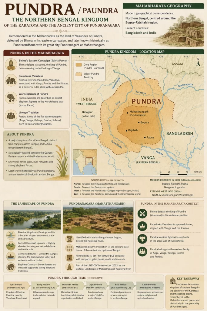
Pundra should be placed principally across northern Bangladesh, centred on the Bogura–Rajshahi–Pabna region and the old Karatoya-Barind landscape, with a western extension through the wider Dinajpur country into present-day West Bengal in India.
The strongest point on the map should be Mahasthangarh near Bogura, identified historically with Pundranagara. However, the coloured kingdom zone should extend considerably beyond the city because Pundra was a country rather than a city-state.
Its southern frontier should remain approximate towards the Padma system, while the west should transition towards the Ganges-Mahananda country and the east towards the Karatoya-Jamuna-Brahmaputra world. The northern boundary is even more difficult to reconstruct for the epic period and should therefore remain deliberately approximate.
Most importantly, the map must cross the modern Bangladesh-India border. Ancient northern Bengal formed a continuous geographical region long before that border existed.
The Epic Landscape of Pundra
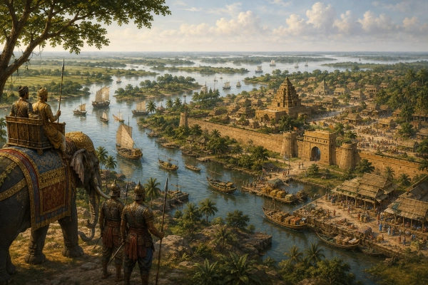
Imagine approaching Pundra from Magadha during Bhima’s eastern campaign. The landscape gradually changes as the traveller moves deeper into Bengal. Rivers multiply, lowlands spread between older elevated terraces, and the countryside becomes increasingly shaped by water.
Beyond the cultivated plains rise fortified settlements surrounded by villages and agricultural land. Boats travel along channels carrying grain, people and merchandise, while elephants move through military encampments and forest margins.
Somewhere within this northern Bengal country stands the power of the king whom the epic calls Vasudeva of Pundra.
Bhima’s army arrives from the west.
The Pundra ruler resists.
The Mahabharata records the outcome simply: Bhima defeats him and moves onward towards Vanga. Yet behind those few lines lies an entire geographical world—a kingdom controlling fertile river plains at the meeting point of the Ganges and Brahmaputra spheres.
Centuries later, a great fortified city called Pundranagara would stand beside the Karatoya in the same northern Bengal landscape.
Its ruins survive today at Mahasthangarh.
Pundra — The Northern Kingdom of Bengal
Pundra is one of the strongest geographical identifications available in the eastern section of our Mahabharata map. The epic repeatedly places the Pundras among the eastern peoples, connects their king with Vanga and the Kiratas, records Bhima’s conquest of their ruler and later remembers Pundra warriors among the elephant-fighting forces of Kurukshetra.
Later history preserves the same name in Pundravardhana, one of ancient Bengal’s most important territorial divisions. The discovery of Pundranagara at Mahasthangarh provides an extraordinary archaeological anchor for the regional identity, while the Karatoya and Barind landscape explains why an important political centre could develop there.
For our reconstruction, the kingdom should therefore occupy the northern Bengal plains centred on modern Bogura and Rajshahi in Bangladesh, extending westward through the Dinajpur region across today’s Bangladesh-India border. The precise epic boundaries cannot be recovered, but the regional identification is considerably stronger than a simple guess based on a surviving place name.
Pundra also reminds us that the Bengal of the Mahabharata was politically diverse. Vanga did not encompass every eastern land, nor was the entire region represented by one kingdom. Pundra, Vanga, Suhma, Anga and the neighbouring peoples each occupied their own place within the epic’s eastern world.
Long before modern borders divided Bengal, the rivers of the north connected its fields, settlements and kingdoms into one great landscape. At its heart flowed the Karatoya, and beside that river the name of the Pundras endured strongly enough to survive into one of the earliest known cities of Bengal.
Pundra was the northern kingdom of ancient Bengal—the country of the Karatoya and the Barind plains, remembered by the Mahabharata as the land of Paundraka rulers and elephant warriors, and preserved historically in the great Pundranagara whose fortified remains still rise at Mahasthangarh.
You may also like
-
Vanga — The River Kingdom of the Bengal Delta and the Eastern Sea
-
Kishkindha — The Boulder Kingdom of Pampa, Rishyamukha and the Tungabhadra
-
Setu — The Sacred Southern Crossing Between Rameswaram and Lanka
-
One Voice – One Resolve – One India: Namami Bharatam Marks 150 Years of Vande Mataram Across the Nation
-
Dravida — The Ancient Tamil Country of Rivers, Temples and the Southern Ocean
