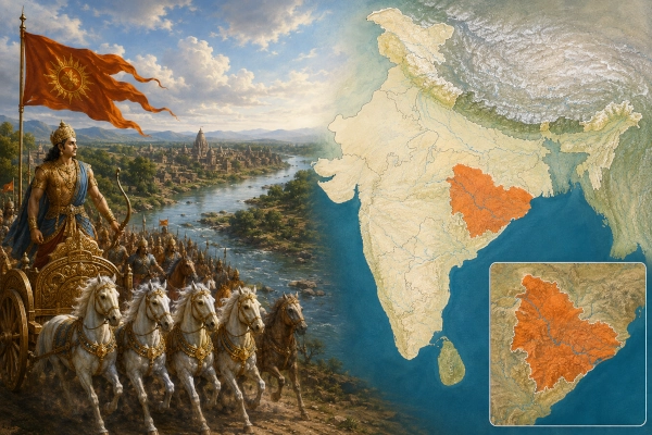
Among the ancient geographical regions associated with the Mahabharata, Dakshina Kosala — Southern Kosala — occupies an important position in central-eastern India. Unlike the better-known northern Kosala centred on Ayodhya and the Sarayu, Dakshina Kosala developed south of the Vindhyan belt, broadly across the fertile plains and river valleys of what are today Chhattisgarh and adjoining western Odisha.
The region formed an important bridge between the Gangetic kingdoms of northern India, the Narmada valley, Vidarbha, Kalinga and the deeper Deccan.
In the Mahabharata, territories identified with southern and eastern Kosala appear particularly during Sahadeva’s southern Digvijaya, the military expedition undertaken before Yudhishthira’s Rajasuya Yajna.
Later historical records make the geographical identity of Dakshina Kosala much clearer. The name became firmly associated with the Chhattisgarh plains and the upper Mahanadi valley extending into western Odisha, and important cities such as Sirpur, Malhar, Tummana and Ratnapura rose within this wider cultural region.
Thus Dakshina Kosala provides an important example of how a geographical name appearing in India’s epic and Puranic traditions continued to survive as a recognisable political region for many centuries.
Dakshina Kosala at a Glance
| Feature | Description |
|---|---|
| Ancient Region | Dakshina Kosala / South Kosala |
| Meaning | Southern Kosala |
| Modern Core Region | Chhattisgarh |
| Eastern Extension | Parts of western Odisha |
| Major River System | Mahanadi and its tributaries |
| Mahabharata Connection | Sahadeva’s southern Digvijaya |
| Associated Epic Regions | Vidarbha, Avanti, Mekala, Kantaraka, eastern Kosala |
| Later Important Capital | Sripura — modern Sirpur |
| Other Later Centres | Malhar, Tummana, Ratnapura |
| Modern Country | India |
Where Was Dakshina Kosala?
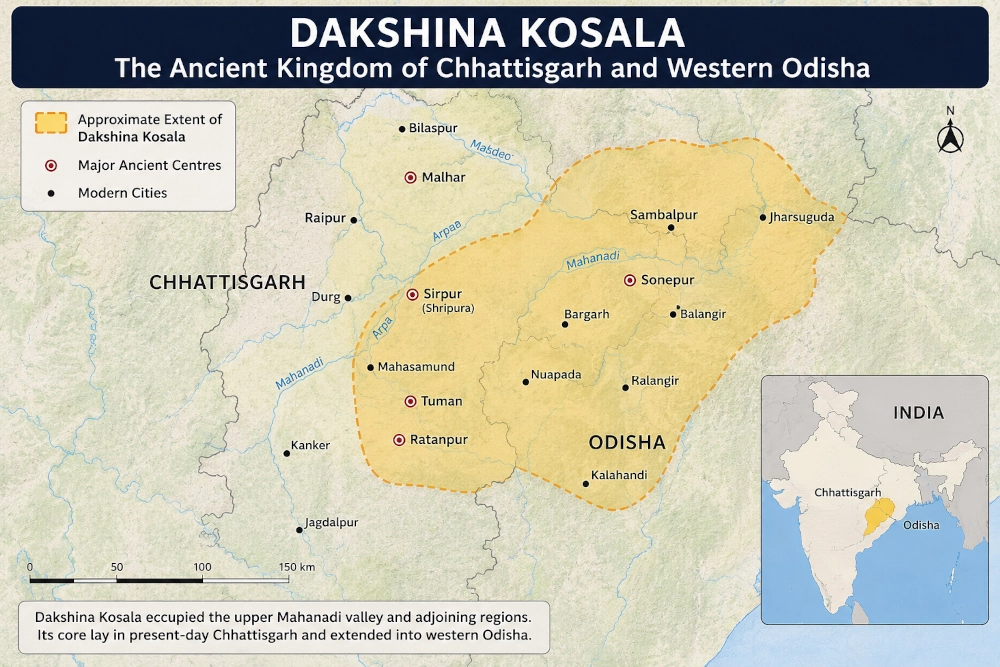
The most widely accepted historical location of Dakshina Kosala corresponds broadly to present-day Chhattisgarh together with parts of western Odisha.
Within Chhattisgarh, the region included much of the great central plain formed by the Mahanadi and its tributaries.
Historically associated areas include regions around:
- Raipur
- Mahasamund
- Bilaspur
- Durg
- Janjgir-Champa
- Raigarh
- Baloda Bazar
- parts of northern and central Chhattisgarh
Its eastern cultural sphere extended into the upper Mahanadi basin of western Odisha, including areas historically associated with:
- Sambalpur
- Bargarh
- Balangir
- Subarnapur
- Kalahandi
- parts of Sundargarh
These should not be interpreted as exact ancient administrative boundaries.
Like most kingdoms and regions described in ancient Indian literature, the boundaries of Dakshina Kosala changed across different centuries and dynasties.
For our modern geographical series, the safest identification is therefore:
Dakshina Kosala → Chhattisgarh and adjoining western Odisha → India
Why Was It Called Southern Kosala?
The name distinguished this region from the famous Kosala of Ayodhya in northern India.
Northern Kosala was centred upon the Sarayu and the great royal city of Ayodhya.
Dakshina Kosala lay considerably farther south, beyond the central Indian highlands and within the Mahanadi basin.
Ancient and medieval geographical traditions therefore used the designation Dakshina Kosala — Southern Kosala to differentiate the central Indian region from the northern Kosala homeland.
This distinction becomes essential when reading the epics because references simply to “Kosala” do not always identify which geographical division is intended.
Dakshina Kosala in the Mahabharata
The clearest Mahabharata connection comes during Sahadeva’s Digvijaya, undertaken before Yudhishthira’s Rajasuya sacrifice.
The Pandava brothers were sent in the four directions to obtain political submission and tribute from the rulers of Bharatavarsha.
Sahadeva was assigned the southern direction.
His campaign took him through a succession of kingdoms extending from central India towards the Deccan.
The Sabha Parva describes Sahadeva first defeating several rulers and then proceeding through the Narmada region.
He defeated Vinda and Anuvinda of Avanti before moving farther south and east.
After defeating Bhishmaka, the powerful ruler associated with Bhojakata and Vidarbha, Sahadeva encountered territories described as:
- Kosala;
- the lands along the Venwa;
- the Kantarakas;
- and the kings of the eastern Kosalas.
The geographical sequence is particularly significant.
Sahadeva was already campaigning south of the Gangetic plain and moving through central India and Vidarbha. The Kosala territories appearing in this context are therefore commonly associated by traditional geographical interpretation with Southern or Dakshina Kosala rather than Ayodhya’s northern Kosala.
Sahadeva’s Southern Campaign
Sahadeva’s expedition was one of the four great campaigns that established Yudhishthira’s imperial authority before the Rajasuya.
After leaving Indraprastha, he proceeded through several regions of central and southern Bharat.
The campaign eventually carried him through:
- central Indian kingdoms;
- the Narmada valley;
- Avanti;
- Bhojakata and Vidarbha;
- Kosala-related territories;
- forest kingdoms;
- regions farther into the Deccan;
- and eventually towards the southern extremities of the subcontinent.
Dakshina Kosala therefore stood along one of the major corridors connecting northern and southern India.
The placement of the region within Sahadeva’s route is consistent with its later historical location in the Mahanadi-Chhattisgarh region between the Narmada-Vindhyan zone and eastern India.
Kosala and the Eastern Kosalas
The Sabha Parva makes an interesting distinction between a king of Kosala and the kings of the eastern Kosalas.
This suggests that Kosala was not necessarily represented by one single political unit throughout the period reflected by the epic.
There may have been several related Kosala territories or dynastic branches.
Ancient geographical names frequently described broader cultural regions containing several rulers.
Consequently, “Dakshina Kosala” is best understood as a historical-geographical zone whose internal political divisions could change over time, rather than as a kingdom with permanently fixed borders.
The Kantarakas and the Forest Frontier
The Mahabharata mentions the Kantarakas alongside the Kosala territories subdued by Sahadeva.
The Sanskrit term kantara is associated with forest or wilderness regions.
This is highly relevant to the geography of central India.
Ancient Dakshina Kosala contained enormous forest belts connecting the Chhattisgarh plain with the Vindhyas, Odisha highlands and the territories extending towards Bastar.
Even today the wider region retains major forest landscapes.
In the Mahabharata period, these forests would have contained numerous local communities and smaller chiefdoms controlling routes between the plains and the interior.
Dakshina Kosala therefore occupied an ecological frontier where:
fertile agricultural plains, forest kingdoms, river valleys and trade routes converged.
The Mahanadi: Lifeline of Dakshina Kosala
If the Sarayu defined northern Kosala, the great river most closely associated with historical Dakshina Kosala is the Mahanadi.
The Mahanadi rises in present-day Chhattisgarh and flows eastward across the plains before entering Odisha and eventually reaching the Bay of Bengal.
Its basin provided:
- fertile agricultural land;
- water for settlements;
- transport corridors;
- access between Chhattisgarh and Odisha;
- and routes linking central India with the eastern coast.
Many important historical centres of Dakshina Kosala developed within this river system.
Among them, Sirpur — ancient Sripura — rose directly beside the Mahanadi.
The river therefore played an important role in binding together the central and eastern portions of the region.
A Bridge Between North, South and East
The strategic importance of Dakshina Kosala becomes clearer when placed on the map of ancient Bharat.
To its northwest lay:
Avanti and the Narmada valley.
To its north were:
Mekala and the Vindhyan regions.
To its west and southwest lay:
Vidarbha and the Deccan.
To its east were:
Kalinga and the coastal regions of Odisha.
Farther north-east lay the Gangetic kingdoms.
Dakshina Kosala therefore occupied an important central corridor through which merchants, armies, pilgrims and cultural traditions could travel between different regions of India.
This explains why the territory repeatedly attracted powerful dynasties in later centuries.
Dakshina Kosala and the Rajasuya Political Order
Sahadeva’s conquest of the Kosala territories was not necessarily an attempt to annex them directly into the Pandava kingdom.
The objective of the Digvijaya campaigns was primarily political.
Yudhishthira wished to perform the Rajasuya, a royal sacrifice requiring recognition of his superior status by other rulers.
The Pandava expeditions therefore sought:
- submission;
- tribute;
- diplomatic recognition;
- and participation in the imperial sacrifice.
Defeated rulers often remained in possession of their kingdoms.
Dakshina Kosala’s submission therefore incorporated the region into the broad political order surrounding Yudhishthira’s Rajasuya without necessarily abolishing its local monarchy.
Did Dakshina Kosala Fight at Kurukshetra?
This question requires some caution.
The Mahabharata contains numerous references to Kosalas among the forces participating in the great conflict.
However, it is not always possible to determine whether every reference means:
- northern Kosala centred on Ayodhya;
- southern Kosala;
- eastern Kosala;
- or another political division carrying the Kosala name.
Brihadbala, the famous Kosala king slain by Abhimanyu, is normally connected with Ayodhya’s Kosala tradition and should therefore not automatically be identified as the ruler of Dakshina Kosala.
For this reason, it would be inaccurate to assign all Kosala warriors in the Kurukshetra narrative specifically to Chhattisgarh.
The strongest explicit Mahabharata connection for Dakshina Kosala as a geographical region remains Sahadeva’s southern campaign.
Dakshina Kosala Beyond the Mahabharata
Unlike several ancient kingdoms whose names gradually disappeared, Dakshina Kosala survived as an important geographical designation deep into India’s historical period.
Centuries after the epic tradition, inscriptions and dynastic records clearly identify a major political territory bearing the name Dakshina Kosala.
This later historical evidence is extremely useful because it helps establish the region’s geographical location.
The heartland centred increasingly on the Chhattisgarh plains and upper Mahanadi valley.
Sirpur: The Great Capital of Dakshina Kosala
One of the greatest cities to emerge within Dakshina Kosala was Sripura, modern Sirpur in Chhattisgarh.
Situated on the banks of the Mahanadi in today’s Mahasamund district, Sirpur became an important political, religious and cultural centre.
It served as a capital under important ruling houses associated with Dakshina Kosala.
The ruins at Sirpur reveal an exceptionally rich urban civilisation containing:
- Hindu temples;
- Buddhist monasteries;
- Jain remains;
- royal structures;
- sculptures;
- inscriptions;
- and extensive archaeological deposits.
The celebrated Lakshmana Temple at Sirpur remains one of the finest surviving early brick temples in India.
Sirpur demonstrates how the region known as Dakshina Kosala continued to flourish many centuries after the period remembered in the epics.
Malhar and the Ancient Kosala Region
Another important archaeological centre is Malhar near Bilaspur.
The Bilaspur region is officially described by Chhattisgarh Tourism as having formed part of historical Dakshina Kosala.
Malhar, ancient Mallala or Mallar, contains archaeological remains extending across a long period of Indian history.
Together with Sirpur, it demonstrates that the Chhattisgarh plain possessed substantial urban and religious centres well before the medieval period.
Tummana and Ratnapura
In later centuries, political centres shifted.
Tummana, identified with modern Tuman, became associated with the Kalachuri rulers.
Later Ratnapura — modern Ratanpur near Bilaspur — emerged as another important royal capital.
These shifts demonstrate that Dakshina Kosala was not permanently tied to one city.
Its political centre changed as different dynasties gained control of the region.
The geographical identity of the country, however, continued.
The Panduvamshis of Dakshina Kosala
One of the most interesting later dynasties associated with this territory was the Panduvamshi dynasty of Dakshina Kosala.
They ruled substantial portions of present-day Chhattisgarh during the early medieval period, with Sripura/Sirpur serving as their principal centre.
Their dynastic name invoked descent from the Pandavas, illustrating the continuing prestige of the Mahabharata tradition in Indian kingship many centuries after the epic age.
Such genealogical claims should not automatically be treated as literal historical descent.
They nevertheless demonstrate how deeply the Pandavas had become embedded within ideas of royal legitimacy.
A dynasty ruling the very region associated in epic geography with Sahadeva’s southern conquest later chose to identify itself with the Pandava tradition.
Dakshina Kosala and Western Odisha
The eastern part of Dakshina Kosala extended into what is today western Odisha, especially the upper Mahanadi valley.
Historical studies commonly associate parts of:
- Sambalpur;
- Balangir;
- Subarnapur;
- Kalahandi;
- and neighbouring regions
with the broader Dakshina Kosala cultural sphere at different times.
The Odisha government’s historical material for Sundargarh also preserves the region’s association with Dakshina Kosala.
This eastern extension is geographically logical.
The Mahanadi does not stop at a modern state boundary.
It connects the plains of Chhattisgarh naturally with western Odisha, creating a continuous historical corridor.
Dakshina Kosala Was Not Kalinga
Dakshina Kosala should also be distinguished from Kalinga.
Both eventually formed important parts of the historical geography of what is now Odisha, but they represented different regions.
Broadly:
Dakshina Kosala was associated with the inland upper Mahanadi basin and Chhattisgarh-western Odisha zone.
Kalinga was associated more strongly with Odisha’s eastern and southeastern regions and the adjoining northern Andhra coast at different historical periods.
The borders between such regions changed frequently, particularly when powerful dynasties expanded their territories.
But treating Dakshina Kosala and Kalinga as identical would erase an important feature of ancient eastern Indian geography.
The Forests, Minerals and Agriculture of the Region
Dakshina Kosala possessed considerable natural advantages.
The central Chhattisgarh plain provided fertile agricultural land, particularly suitable for rice cultivation.
The surrounding highlands contained extensive forests.
The wider region also possessed important mineral resources.
These factors would have supported:
- agriculture;
- forest produce;
- metallurgy;
- craft production;
- elephant resources;
- and overland commerce.
The Mahanadi and its tributaries provided an additional geographical framework for settlement.
The combination of fertile plains and resource-rich uplands helps explain why the region repeatedly supported substantial kingdoms.
A Cultural Meeting Ground
The later archaeology of Dakshina Kosala reveals another striking feature: extraordinary religious diversity.
At Sirpur and elsewhere, evidence survives for:
- Shaivism;
- Vaishnavism;
- Shaktism;
- Buddhism;
- Jainism
existing within the same broader cultural environment.
This reflects the region’s position at the meeting point of northern, central, eastern and southern India.
Trade routes brought not simply merchandise but also monks, teachers, artisans, texts and artistic traditions.
Dakshina Kosala consequently developed a distinctive cultural identity while remaining deeply connected with the wider civilisation of Bharat.
Dakshina Kosala and Northern Kosala
For our Mahabharata geography series, the distinction between the two Kosalas is particularly important.
Northern Kosala
Centred on:
Ayodhya and the Sarayu
Modern identification:
Awadh and neighbouring Uttar Pradesh
Dakshina Kosala
Centred historically on:
the Chhattisgarh plain and upper Mahanadi basin
Modern identification:
Chhattisgarh and adjoining western Odisha
The shared name reflects ancient cultural and dynastic traditions, but by historical times the two regions were separated by hundreds of kilometres.
They should therefore appear as distinct areas on a modern map.
Dakshina Kosala on the Modern Map of India
For a modern geographical reconstruction, Dakshina Kosala should be shown primarily across central and northern Chhattisgarh, extending eastwards into western Odisha.
The broad modern representation may include the zones around:
Raipur – Mahasamund – Bilaspur – Janjgir-Champa – Raigarh – Sambalpur – Balangir – Subarnapur – parts of Kalahandi and Sundargarh.
The boundaries must remain approximate.
Ancient kingdoms did not possess surveyed borders comparable to modern Indian states, and the extent of Dakshina Kosala changed repeatedly.
Modern Identification
| Ancient Geography | Modern Geography |
| Dakshina Kosala | Chhattisgarh and western Odisha |
| Principal River System | Mahanadi |
| Later Major Capital | Sirpur, Chhattisgarh |
| Other Historical Centres | Malhar, Tummana, Ratanpur |
| Modern States | Chhattisgarh and Odisha |
| Modern Country | India |
Dakshina Kosala’s Place in the Mahabharata
Dakshina Kosala does not dominate the personal drama of the Mahabharata in the way that Kuru, Panchala, Gandhara or Matsya do.
Its importance is instead geographical.
When Sahadeva travelled south to establish Yudhishthira’s authority, the Kosala territories of central India formed part of the chain of kingdoms linking the northern plains to Vidarbha, the forests of central India and the Deccan.
The campaign demonstrates that the political world envisioned by the Mahabharata extended far beyond Hastinapura and Indraprastha.
It encompassed a vast network of states, forest territories, river valleys and regional powers.
Dakshina Kosala belonged to that larger world.
And unlike many ancient geographical names, it did not vanish after the age of the epics.
Centuries later, inscriptions and kingdoms still spoke of Dakshina Kosala.
Great centres such as Sirpur flourished within it. Dynasties rose and fell across its plains. The Mahanadi continued to connect its interior with eastern India.
Today, the ancient name survives in the historical identity of Chhattisgarh and western Odisha, preserving another remarkable link between the geography of the Mahabharata and the map of modern India.
Reference
Mahabharata — Sabha Parva, Digvijaya Parva, Chapter 30
Sahadeva’s southern campaign; his defeat of the king of Kosala, the ruler of the Venwa region, the Kantarakas and the kings of the eastern Kosalas.
Mahabharata — Sabha Parva
The four Pandava Digvijaya campaigns undertaken before Yudhishthira’s Rajasuya Yajna.
Chhattisgarh Tourism Board — Bilaspur
Official historical reference identifying the Bilaspur region with Dakshina Kosala and noting ancient centres including Malhar, Sirpur, Tummana and Ratnapura.
Chhattisgarh Tourism Board — Raipur
Official historical account identifying the Raipur region as formerly part of the Dakshina Kosala Kingdom.
Government of Odisha — Sundargarh District Profile
Historical reference connecting parts of present-day western Odisha with the wider Kosala tradition.
Odisha Review — Government of Odisha
Historical discussion of Dakshina Kosala as a region spanning the upper Mahanadi valley of western Odisha and adjoining Chhattisgarh.
Historical and archaeological studies of Sirpur/Sripura
Evidence for the later political and cultural development of Dakshina Kosala.
You may also like
-
Sauvira: The Indus Realm Linked With Jayadratha in the Mahabharata
-
Sindhu: The Indus Kingdom of Jayadratha in the Mahabharata
-
Kuninda or Kulinda: The Himalayan Realm of the Mahabharata in Uttarakhand and Himachal Pradesh
-
Durga versus Mahishasura: Weapons, Battlefield Tactics and the Triumph of Shakti
-
Kuluta: The Kullu Valley Kingdom of the Mahabharata
