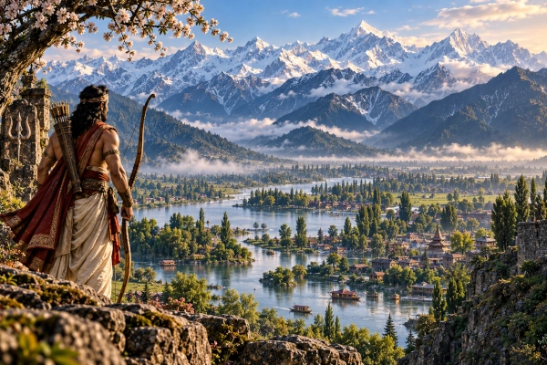
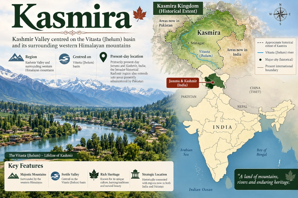
The ancient land of Kasmira, or Kāśmīra, is one of the northern regions named explicitly in the Mahabharata. Its geographical core can be identified with considerable confidence as the Kashmir Valley, the fertile intermontane basin through which the ancient Vitasta, now the Jhelum River, flows. Enclosed by the Pir Panjal on the southwest and the higher Himalayan ranges to the northeast, Kasmira occupied a naturally protected position within the northwestern Himalayas while remaining connected to Gandhara, the Punjab, the Darada country and the wider mountain world of northern Bharatavarsha.
This identification is stronger than many attempted correlations between epic kingdoms and modern geography because the Mahabharata itself places the sacred river Vitasta “in the country of the Kasmiras.” The Vitasta remains the principal river of the Kashmir Valley, flowing northwest through the basin before leaving it through the Baramulla gorge. The river therefore provides a direct geographical link between the Kasmira of the epic and historical Kashmir.
The name should nevertheless be used carefully. Ancient Kasmira principally denoted the Valley and its immediate mountain environment, not the entirety of the much larger territories that were incorporated into the princely state of Jammu and Kashmir in the nineteenth century. In modern terms, the core ancient region lies in the Kashmir Valley within the Union Territory of Jammu and Kashmir, India. The broader historical-geographical idea of Kashmir later came to encompass a much wider Himalayan area, portions of which are today administered by India and Pakistan. The ancient Kasmira of the Mahabharata, however, is best understood first and foremost as the Valley itself. Aurel Stein, in his study of ancient Kashmir, similarly observed that the Sanskrit geographical tradition places Kasmira in the northern hill country and that the epic refers repeatedly to its people and rulers.
A Valley Enclosed by Mountains
Few ancient regions possessed boundaries as naturally recognisable as Kashmir.
The Kashmir Valley is a broad basin ringed by high mountains. The Pir Panjal Range forms its great southwestern barrier, separating it from the Punjab and Jammu hills, while the Greater Himalayan ranges rise towards the northeast. Between these mountain walls lies a comparatively level and fertile valley watered by the Jhelum and its tributaries. Archaeological research describes Kashmir as an intermontane valley on the southwestern edge of the Himalayan system, possessing a distinctive prehistoric cultural sequence shaped partly by its protected but connected geography.
This enclosed terrain gave Kasmira a character different from the open kingdoms of the Gangetic plain.
Entry into the Valley depended upon mountain passes, river corridors and narrow approaches. The route through the Jhelum gorge offered access from the west, while passes across the Pir Panjal connected the Valley with the southern plains. Other routes led north and northeast towards the higher Himalayas.
Kasmira was therefore sheltered, but never isolated.
Its position allowed contact with Gandhara and the Punjab to the southwest, Darada territories to the north and northwest, and other Himalayan communities to the east. The Mahabharata’s geographical lists repeatedly place Kasmiras alongside precisely such northern and northwestern peoples.
Kasmira in the Mahabharata’s Map of Bharatavarsha
The Bhishma Parva contains one of the epic’s broadest catalogues of the peoples and countries of Bharatavarsha. Among the territories named are the Kasmiras, Sindhu-Sauviras, Gandharas, Abhisaras and other northern peoples. In another portion of the same geographical account, the Kasmiras appear alongside the Daradas and other communities of the northern and mountainous world.
These associations are geographically meaningful.
Gandhara lay beyond the northwestern approaches of the subcontinent, while the Daradas were associated with the upper Indus and mountain regions north and northwest of Kashmir. Abhisara is generally placed in the hill country south and southwest of the Valley. The grouping therefore reflects a coherent northwestern geographical zone rather than an arbitrary list of distant peoples.
Kasmira belonged to this Himalayan frontier world but possessed a distinct identity of its own.
The Mahabharata does not portray it simply as a vague mountain tract. It refers to Kasmiras as a people and to a king of Kashmira, indicating an organised political territory recognised alongside the other kingdoms represented in the epic.
The King of Kasmira at Yudhishthira’s Rajasuya
Kasmira appears prominently during the preparations for Yudhishthira’s Rajasuya sacrifice.
The Sabha Parva describes rulers arriving from numerous regions of Bharatavarsha to attend the ceremony at Indraprastha. Among the kings of Vanga, Kalinga, Gandhara, Sindhu and other distant lands, the text explicitly includes the king of Kashmira. These rulers came bearing valuable gifts and participating in the imperial gathering that demonstrated the extraordinary extent of Yudhishthira’s political recognition.
The reference is important because it establishes Kasmira as more than a geographical name.
The epic recognises a ruler representing the country, placing Kasmira within the political world of the northern subcontinent. Its king could travel from the Himalayan Valley to the Kuru realm and participate in the great ceremonial assembly alongside the monarchs of major kingdoms.
Such an appearance also suggests that the mountain barriers surrounding Kashmir did not prevent regular political communication with the plains.
Routes across the western Himalayas linked Kasmira to the larger network of royal courts, trade centres and pilgrimage routes that connected ancient northern India.
Vitasta: The River That Identifies Kasmira
The strongest geographical marker for Kasmira in the entire Mahabharata is the Vitasta.
During the Vana Parva’s description of sacred pilgrimage places, the epic instructs the pilgrim to proceed to Vitasta, perform offerings there and bathe in its waters. It then states directly that this sacred tirtha is situated in the country of the Kasmiras and associates it with the Naga Takshaka.
The Vitasta is securely identified with the Jhelum River.
Its river system dominates the physical geography of the Kashmir Valley. The Jhelum rises in southeastern Kashmir, flows through the Valley and Srinagar, passes through Wular Lake and eventually leaves the basin through the narrow gorge near Baramulla before continuing westward. Historical geographical accounts have consistently identified the Sanskrit Vitasta with the Jhelum.
This makes the identification of Kasmira unusually precise.
The epic is not simply locating a people somewhere in the Himalayan north. It names their country and then places within it a river whose modern geographical identity is known.
The landscape described by the text is therefore still recognisable: Kasmira was the country of the Vitasta.
Vitasta and the Sacred Geography of Kashmir
The religious importance of the Vitasta did not end with the Mahabharata.
Later Kashmirian Sanskrit tradition developed an elaborate sacred geography around the river, springs, lakes, mountains and Naga sites of the Valley. The Nilamata Purana, one of the most important early texts devoted specifically to Kashmir, gives the Vitasta an especially exalted position and describes the river as sacred throughout its course.
The river became more than a physical waterway. It formed the central axis around which numerous tirthas and ritual landscapes were organised.
This later tradition is particularly useful when reading the earlier Mahabharata passage. The epic’s brief reference to the Vitasta as a sacred tirtha in Kasmira fits a much larger regional religious tradition in which the river, springs and Nagas were closely connected.
The association with Takshaka, one of the most famous Nagas in the Mahabharata, is especially striking. Nagas occupy an important place in the sacred traditions of Kashmir, where numerous springs and water sources acquired associations with particular Naga deities.
The Nagas and the Memory of the Valley
Kashmir’s later Sanskrit traditions preserve an unusually strong connection between the Valley and the Nagas.
The Nilamata Purana presents Nagas as fundamental inhabitants and guardians of the land, while the Rajatarangini and local traditions preserve the names of numerous sacred springs associated with them. The surviving landscape itself retains this memory in place names ending in -nag, derived from the Sanskrit naga and often associated locally with springs.
The Mahabharata’s placement of Takshaka at the Vitasta therefore belongs to a wider cultural pattern rather than standing as an isolated reference.
This does not mean that Kasmira should simply be described as a “Naga kingdom” in a modern ethnic sense. The Nagas of Sanskrit literature occupy overlapping mythological, religious and sometimes political roles. The safest conclusion is that Naga traditions were deeply embedded in the sacred geography of ancient Kashmir, especially around water sources.
Later Kashmiri literature preserves this relationship with extraordinary richness.
Kasmira and the Darada Country
The Mahabharata frequently associates the Kasmiras with the Daradas, an important clue to the northern extent of its geographical knowledge.
Darada country is generally connected with the mountainous upper Indus regions north and northwest of Kashmir. The Daradas appear repeatedly among the northern peoples of Sanskrit literature and are often listed alongside the Kasmiras.
This relationship reflects the physical geography of the region.
Beyond the northern mountains of Kashmir lay valleys leading towards Gilgit, the upper Indus and the high ranges separating the subcontinent from Central Asia. These regions supported communities with their own political and cultural identities but maintained contact with Kashmir through mountain corridors.
The epic’s pairing of Kasmira and Darada therefore places both within a coherent Himalayan zone while recognising them as distinct peoples.
Kasmira occupied the enclosed valley; the Darada world began beyond its northern and northwestern mountain approaches.
Kasmira, Gandhara and the Northwestern Routes
To the southwest lay another major neighbour in the epic world: Gandhara.
Gandhara was centred farther west around regions corresponding broadly to the Peshawar Valley and adjoining areas. Between Kasmira and Gandhara lay a succession of hill routes and smaller territories connecting the Valley with the northwestern plains.
The Mahabharata’s geographical lists repeatedly place Kasmira within this larger northwestern group.
This relationship mattered economically as well as politically. Kashmir’s mountain routes connected it with the Punjab and the greater northwestern trade network. Goods could move through these corridors towards Gandhara and onwards towards Central Asia, while commodities from the plains reached the Valley through the same mountain passages.
The geography made Kasmira both a protected interior basin and a participant in long-distance exchange.
Mountain Wealth and the Economy of the Valley
The natural environment of Kasmira supported a distinctive economy.
Its relatively fertile valley floor allowed agriculture, while the surrounding mountains provided forests, pastures, animals and valuable natural resources. Later historical Kashmir became famous for wool, fine textiles, timber, fruit and specialised crafts, but the underlying economic advantage was already present in the geography of the Valley.
Mountain routes also made Kashmir an intermediary between different ecological zones.
Products from the high Himalayas could move southwards, while grain, manufactured goods and other commodities entered from the plains. This relationship between mountain and lowland economies is repeatedly visible elsewhere in the Mahabharata, particularly when Himalayan peoples bring distinctive forest and mountain products to royal gatherings.
Kasmira belonged to the same economic world, although its fertile enclosed basin gave it a more settled agricultural base than many smaller Himalayan chiefdoms.
An Ancient Name with Deep Roots
The name Kasmira or Kashmira is itself ancient.
Aurel Stein noted that forms of the name occur in early Sanskrit grammatical traditions associated with Panini and Patanjali, while the Mahabharata refers to the Kasmiras and their rulers in several passages. He also emphasised that the epic’s references are generally broad enough to establish the country’s northern hill location but not detailed enough to reconstruct precise political boundaries.
That caution is important.
The Kashmir Valley provides the secure geographical core, but there is little basis for drawing a precise Mahabharata-era border around every surrounding mountain district. Political control in Himalayan terrain could change considerably, and ancient kingdoms rarely corresponded to modern administrative boundaries.
The most accurate reconstruction therefore begins with the Vitasta basin and Kashmir Valley, then allows for influence over adjoining mountain territories without assuming that every later possession of Kashmir belonged to ancient Kasmira.
The Nilamata Purana and the Creation of a Kashmiri Sacred Landscape
If the Mahabharata gives Kasmira a place within the broader geography of Bharatavarsha, the Nilamata Purana gives the Valley a sacred geography of its own.
The text describes rivers, springs, lakes, mountains, pilgrimage centres and regional festivals in remarkable detail. Modern scholarship has recognised the Nilamata as an important example of how a regional landscape was incorporated into the larger sacred geography of the Indian subcontinent.
The Vitasta lies at the centre of this world.
Its waters connect numerous sacred sites, while other rivers and springs are associated with divine figures and Nagas. The result is an image of Kashmir not as a remote frontier but as a sacred land integrated into the religious geography of Bharatavarsha.
That development is already foreshadowed by the Mahabharata, which places a major tirtha on the Vitasta and includes the Kasmira king within Yudhishthira’s imperial assembly.
From Kasmira to the Rajatarangini
Kashmir later produced one of the most remarkable historical works written in Sanskrit: Kalhana’s Rajatarangini, composed in the twelfth century.
Kalhana attempted to record the succession of Kashmir’s kings by combining earlier chronicles, inscriptions, traditions, genealogies and historical memory. Although its earliest sections contain legendary material, the work becomes increasingly detailed as it approaches periods closer to the author’s own time.
The Rajatarangini is much later than the Mahabharata, and its traditions should not simply be projected backwards into the epic age.
Yet its very existence demonstrates the strength of Kashmir’s regional historical identity. The Valley preserved its own dynastic memory while remaining firmly connected with the Sanskrit literary and religious world of the subcontinent.
This continuity makes Kasmira particularly valuable in a study of Mahabharata geography. The name, river and physical setting remain identifiable across an exceptionally long span of Indian literary history.
Kasmira Was Not the Entire Later Jammu and Kashmir State
One of the most important distinctions in identifying ancient Kasmira is between the Kashmir Valley and the much larger political entities that later carried the Kashmir name.
Historically, “Kashmir” primarily referred to the Valley. Only in much later political history did the name become attached to a state that also included Jammu, Ladakh, Baltistan, Gilgit and other distant mountain territories. These regions possessed distinct geographical and historical identities of their own. A catalogue description of Aurel Stein’s work on ancient Kashmir similarly notes that the term originally denoted the Valley between the Great Himalayas and the Pir Panjal before acquiring its much broader modern political meaning.
Ancient Kasmira should therefore not be mapped automatically across the entire area of the former princely state.
For the Mahabharata, the Vitasta basin and Kashmir Valley provide the secure core.
Its neighbouring Himalayan areas formed part of Kasmira’s wider political and cultural environment, but regions such as Darada, Gandhara and other mountain countries retained separate identities in the epic.
Kasmira in Mahabharata Geography
Ancient name: Kasmira / Kāśmīra
Core region: Kashmir Valley and the Vitasta basin
Modern geographical association: Primarily the Kashmir Valley in Jammu and Kashmir, India; the broader historical region of Kashmir later extended into territories now administered by India and Pakistan
Principal river: Vitasta, identified with the modern Jhelum
Landscape: Fertile intermontane valley surrounded by the Pir Panjal and higher Himalayan ranges
Epic classification: Northern and northwestern kingdom of Bharatavarsha
Neighbouring ancient regions: Darada, Gandhara, Abhisara and other Himalayan territories
Major Mahabharata references: The king of Kasmira attends Yudhishthira’s Rajasuya; Kasmiras appear in geographical catalogues of northern peoples; the sacred Vitasta tirtha is explicitly located in Kasmira
Sacred association: Vitasta and the Naga Takshaka
Later important texts: Nilamata Purana and Kalhana’s Rajatarangini
Kasmira is among the clearest examples of how the geographical world of the Mahabharata can still be recognised in the physical landscape of South Asia.
The mountains remain. The Valley remains. Most importantly, the Vitasta still flows through it.
When the Mahabharata speaks of a sacred tirtha on the Vitasta in the country of the Kasmiras, it anchors the epic narrative to a landscape whose essential form is visible even today. Around that river developed one of the most distinctive cultures of the western Himalayas, connected with the Nagas, mountain pilgrimage, Sanskrit learning and a long regional historical tradition.
Kasmira was neither an indistinct northern frontier nor simply another name in the epic’s catalogue of kingdoms. It was a clearly recognised Himalayan country built around an unusually well-defined natural basin.
In the geography of the Mahabharata, Kasmira was the land of the Vitasta — a mountain-enclosed valley linking the Indian plains with the high northwestern Himalayas and forming one of the enduring northern regions of Bharatavarsha.
You may also like
-
Nepala: The Kathmandu Valley and the Central Himalayan World of the Mahabharata
-
Kirata: The Himalayan and Eastern Hill Peoples of the Mahabharata
-
Kamarupa — The Historic Kingdom of the Brahmaputra Valley and the Eastern Himalayas
-
Bharat Vandana Park: Delhi’s ‘Mini India’ Brings the Nation’s Heritage Together in One Landscape
-
Pragjyotisha — Bhagadatta’s Kingdom of the Brahmaputra Valley
