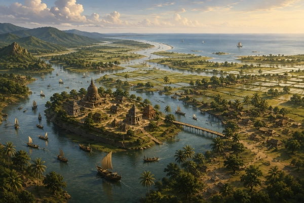
Ancient Geography: Southeastern Bengal, particularly the Comilla–Noakhali plains east of the Meghna
Modern Location: Principally Bangladesh, with historical extensions towards present-day Tripura in India
Samatata in the Geography of Ancient Bengal
Samatata was one of the most important territorial names associated with ancient southeastern Bengal. Its core lay in the fertile, river-cut country east of the Meghna, particularly around present-day Cumilla, Noakhali, Feni, Chandpur and Lakshmipur in Bangladesh. At different periods its political influence extended towards the hills of Tripura in the east and the islands and coastal country facing the Bay of Bengal in the south. Historical and archaeological evidence places the heartland of Samatata firmly in the Comilla–Noakhali plain and the adjoining trans-Meghna region.
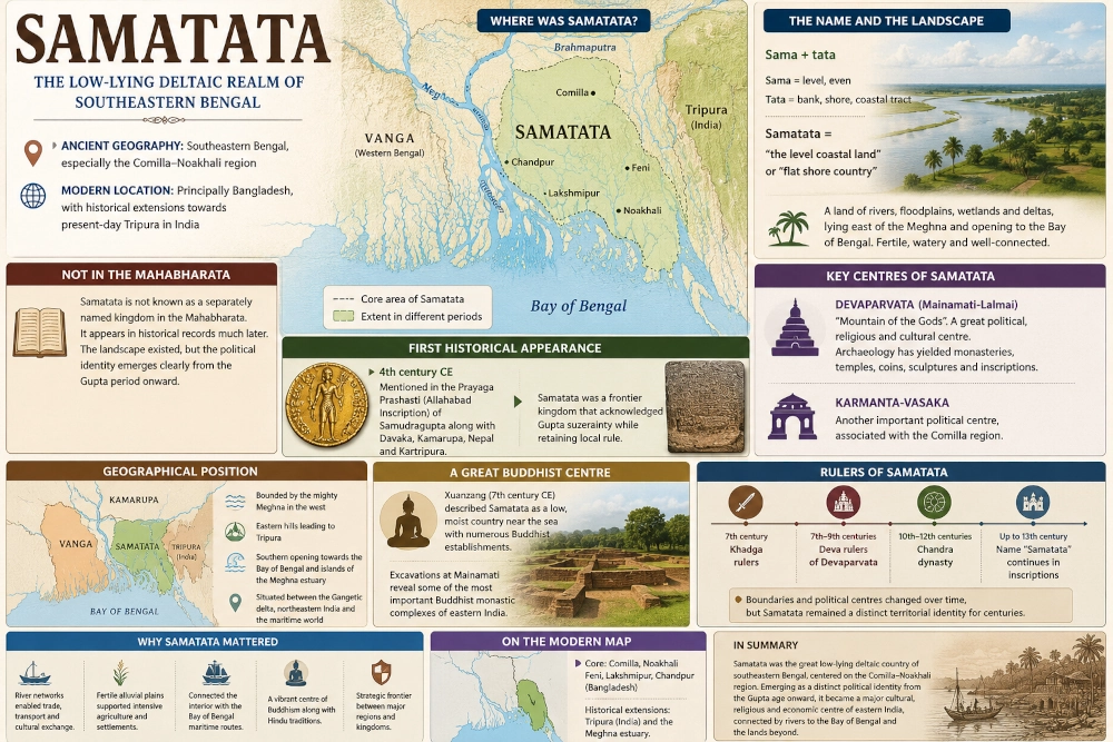
The name itself appears to describe the physical character of the country rather than a particular tribe. Sama conveys the sense of level or even, while tata can denote a bank, shore or coastal tract. Samatata can therefore be understood broadly as the “level coastal land” or “flat shore country”, an apt description for the immense alluvial plains formed by the rivers of eastern Bengal.
A Necessary Distinction from the Mahabharata
Unlike Vanga, Pundra and Suhma, Samatata cannot presently be identified with confidence as a separately named kingdom in the Mahabharata. The surviving historical evidence for the territorial name becomes clear much later, with its earliest secure epigraphic appearance in the fourth-century CE Prayaga or Allahabad Prashasti of Samudragupta. For the period represented by the epic traditions, southeastern Bengal is more safely discussed within the wider geographical world of Vanga and neighbouring eastern peoples rather than projecting the later political name Samatata backwards without evidence.
This distinction is important when reconstructing the geography of the Mahabharata. Ancient regional names were not permanently fixed. River courses changed, coastlines advanced, political centres shifted and new territorial identities emerged. Samatata represents an excellent example of a region whose physical landscape was ancient but whose clearly documented political identity belongs predominantly to the centuries following the epic period.
Between the Meghna and the Eastern Hills
The natural geography of Samatata gave the territory an unusually distinct character. Its western boundary was dominated by the enormous Meghna river system, carrying the combined waters of the Ganga-Padma, Brahmaputra and Meghna towards the Bay of Bengal. To the east rose the hills leading towards Tripura and, farther southeast, the ranges approaching the Arakan region.
Between these geographical barriers stretched a remarkably fertile but water-dominated landscape of floodplains, marshes, river channels, seasonal wetlands and low alluvial country. The region extended southward towards the Bay of Bengal and included coastal and island environments connected with the Meghna estuary. Banglapedia’s reconstruction places Samatata from the country near the Sylhet frontier in the north through the Comilla-Noakhali plains and towards the Bay of Bengal in the south.
This was therefore not simply an inland agricultural kingdom. Rivers, estuaries and coastal waterways formed the principal arteries through which people, goods and political influence could move.
Samatata and Vanga
Samatata must also be distinguished from Vanga, although the boundaries between historical regions of Bengal changed repeatedly. Vanga was one of the much older names associated with Bengal and features prominently in Sanskrit literary traditions. By the historical period, however, Samatata and Vanga could be treated as separate geographical entities.
The sixth-century Brihat Samhita, for example, refers to Samatata and Vanga separately. In broad geographical terms, Vanga was associated more strongly with the central and southern Bengal delta, while Samatata became identified particularly with the eastern or trans-Meghna delta.
The distinction reflects the fragmented character of ancient Bengal. Rather than forming a single political unit, the region consisted at different times of territories such as Vanga, Pundravardhana, Radha, Gauda, Samatata and Harikela, whose boundaries could expand, overlap or contract according to political circumstances.
Samatata Appears in the Gupta Age
The first firm historical appearance of Samatata comes from the celebrated Prayaga Prashasti of Samudragupta, composed in the fourth century CE. The inscription identifies Samatata among the eastern frontier kingdoms associated with the Gupta emperor’s sphere of influence, together with Davaka, Kamarupa, Nepal and Kartripura.
Samatata was therefore situated beyond the principal directly governed heartland of the Gupta Empire. Its rulers acknowledged the imperial power of Samudragupta while retaining a degree of local political identity. This reference demonstrates that by the fourth century Samatata was already recognised as a distinct and sufficiently important eastern kingdom to be named in one of the most significant political inscriptions of the Gupta age.
Mainamati and the Political Heart of Samatata
One of the most important clues to the location of Samatata comes from the extraordinary archaeological landscape around Lalmai and Mainamati near modern Cumilla. Excavations have revealed monasteries, temples, sculptures, coins, seals, inscriptions and extensive architectural remains demonstrating that this area became one of the major political and religious centres of southeastern Bengal.
Among the great cities associated with Samatata was Devaparvata, whose name means approximately the “Mountain of the Gods.” It was located on or around the Mainamati-Lalmai ridge and became an important political, religious and cultural centre. Archaeological work in the area has produced hundreds of coins as well as inscriptions, sculptures and substantial architectural remains.
Another political centre, Karmanta-Vasaka, has been associated with the area near modern Comilla. The concentration of inscriptions and archaeological remains in this region strongly reinforces the identification of the Comilla-Noakhali plain as the central territory of historical Samatata.
A Great Buddhist Centre of Eastern India
Centuries after the period associated with the Mahabharata, Samatata became particularly renowned as a major centre of Buddhism. The Chinese pilgrim Xuanzang, who travelled through the Indian subcontinent in the seventh century CE, journeyed south from Kamarupa to Samatata and described a low, moist country situated near the sea.
He encountered a flourishing religious landscape containing numerous Buddhist establishments. Archaeology at Mainamati, including the great monastic complexes of the region, confirms that southeastern Bengal developed into one of the most important Buddhist cultural zones of eastern India.
The prominence of Buddhism did not erase other religious traditions. Hindu and Buddhist communities existed across the region during different periods, and changing dynasties patronised a diverse cultural environment. Samatata consequently became a meeting ground between the Gangetic plains, northeastern India and the maritime world of the Bay of Bengal.
Dynasties of Samatata
After the decline of Gupta power, southeastern Bengal repeatedly emerged under local ruling houses. The Khadgas controlled Samatata during the seventh century, while subsequent rulers associated with the Deva line established Devaparvata as an important political centre.
The Chandra dynasty, beginning around the tenth century, eventually constructed a much larger eastern Bengal kingdom that incorporated territories associated with both Vanga and Samatata. Political authority consequently shifted between different capitals and dynasties, but the name Samatata continued to survive in inscriptions for centuries. Evidence indicates that it remained a meaningful territorial designation as late as the thirteenth century.
Rivers, Agriculture and Maritime Connections
The prosperity of Samatata was inseparable from water. The Meghna and its enormous network of tributaries continually deposited fertile alluvium across the plains, supporting intensive cultivation. At the same time, the waterways provided natural transport routes connecting settlements that would have been difficult to reach efficiently overland.
The southward opening towards the Bay of Bengal also placed Samatata within the maritime geography of eastern India. Boats could move from the interior river system into the estuary and onward towards other parts of coastal Bengal and the northeastern Bay of Bengal.
Its position was therefore strategic. Samatata stood between the Gangetic delta to the west, Kamarupa and the Brahmaputra world to the north, Tripura to the east and the Bay of Bengal to the south. That geography helps explain why the region repeatedly developed independent political centres despite its proximity to larger northern Indian empires.
The Changing Delta
Modern geography should not simply be imposed upon ancient Samatata. The Bengal delta is one of the most dynamic landscapes on Earth. Rivers have repeatedly shifted their courses, channels have disappeared, new land has formed and older settlements have been buried beneath sediment or destroyed by erosion.
The coastline of southeastern Bengal during antiquity therefore differed from that of modern Bangladesh. Some areas that are now settled agricultural plains may once have been wetlands, estuaries or newly emerging deltaic land. Political boundaries would consequently have followed rivers and ecological zones that no longer correspond exactly with modern administrative districts.
This fluid geography also explains why attempts to assign Samatata rigid modern borders can be misleading. Cumilla and Noakhali provide the clearest core, but Samatata at various times extended considerably beyond them.
Samatata on the Modern Map
For a modern geographical reconstruction, the most reliable placement of Samatata is in southeastern Bangladesh, east of the Meghna, centred especially on Cumilla and Noakhali. The wider historical zone can include Feni, Lakshmipur, Chandpur and neighbouring areas, while political influence at particular periods extended into parts of present-day Tripura in India and towards the coastal islands of the Meghna estuary.
On an ancient-India map, Samatata should therefore be shown east of the main Vanga heartland and west of the Tripura hills, with the Meghna forming the dominant western geographical reference and the Bay of Bengal marking its southern orientation. It should not be stretched across the entirety of Bengal.
Samatata’s Place in Ancient Indian Geography
Samatata demonstrates how the easternmost regions of the Indian subcontinent developed political identities shaped as much by rivers and coastlines as by imperial boundaries. Its low-lying plains connected inland Bengal with the Bay of Bengal while its eastern approaches opened towards Tripura and the lands beyond.
For a reconstruction centred specifically on the Mahabharata, however, Samatata must be treated cautiously. The territory is historically real, but the name is securely documented only from the Gupta period onward. The southeastern Bengal landscape that later became Samatata undoubtedly formed part of the ancient geographical world, but it should not be presented as a clearly named Mahabharata kingdom without stronger textual evidence.
Modern identification: Southeastern Bengal — principally the Cumilla–Noakhali region of present-day Bangladesh, with historical extensions towards adjoining Tripura and the Meghna estuary.
You may also like
-
Tamralipta — The Maritime Gateway of the Lower Ganga
-
Suhma — The River-and-Forest Country of Southwestern Bengal
-
Gauda — The Western Bengal Country of the Bhagirathi and the Rise of Karnasuvarna
-
Pundra — The Northern Bengal Kingdom of the Karatoya and the Ancient City of Pundranagara
-
Vanga — The River Kingdom of the Bengal Delta and the Eastern Sea
