Mahabharata Geography — Vanga
Modern geographical correspondence: Central and southern Bengal, particularly the great deltaic country spanning present-day Bangladesh and adjoining West Bengal, India
Across the easternmost plains of ancient Bharata lay a country unlike the drier kingdoms of the northwest or the rocky lands of the Deccan. Here immense rivers divided repeatedly into channels, monsoon floods spread across wide plains, wetlands and marshes occupied the lower country, and countless waterways eventually carried the waters of northern India towards the Bay of Bengal. Within this river-created landscape the Mahabharata remembers the Vangas, one of the principal peoples of eastern India.
Vanga can be located broadly within central and southern Bengal, spanning territory in modern Bangladesh and adjoining southern West Bengal. Its boundaries changed greatly through time, and it should not be equated with the whole of Bengal. Historical geography places its strongest core broadly between the Bhagirathi system in the west and the Padma-Meghna system in the east, with particularly strong associations with southern and southeastern parts of present Bangladesh and, in earlier periods, portions of southern West Bengal.
This distinction is important because the Mahabharata separately knows Anga, Pundra, Suhma, Tamralipta and Vanga. Ancient Bengal was therefore not remembered as one homogeneous political unit. It consisted of several regional identities created by rivers, settlement patterns, trade routes and changing centres of political power.
Vanga in the Mahabharata
The Vangas appear repeatedly in the Mahabharata, giving the region a much stronger epic presence than many ancient geographical names known only from a single catalogue. They occur in the epic’s legendary genealogies, in Bhima’s eastern campaign before Yudhishthira’s Rajasuya, among the rulers and peoples bringing tribute to Indraprastha, during Arjuna’s travels through eastern India and, most dramatically, in the elephant warfare of Kurukshetra.
These references reveal a region that was politically integrated into the wider world of Bharata despite lying far from Hastinapura. Vanga rulers could be conquered or brought into alliance by the Pandavas, travel to Yudhishthira’s imperial ceremony and later send military forces across northern India to participate in the great war.
The epic consequently does not treat Vanga as an obscure marshland beyond the civilised world. It recognises the Vangas as a distinct and militarily significant eastern people.
The Legendary Birth of Vanga
The Adi Parva preserves an important genealogical tradition explaining the origins of several eastern countries. In the story of the sage Dirghatamas and Queen Sudeshna, the sage blesses the queen with five sons who are named Anga, Vanga, Kalinga, Pundra and Suhma. The epic then explains that countries bearing these names became known upon the earth.
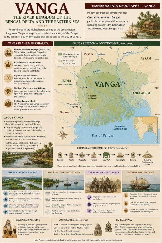
This account belongs to epic genealogy rather than modern political history, but its geographical importance is considerable. It groups together several of eastern India’s most important ancient regions while simultaneously recognising each as distinct. Anga belonged farther west in the lower Gangetic country, Pundra occupied parts of northern Bengal, Suhma was associated more strongly with western and southwestern Bengal, Kalinga stretched southward along the Odisha coast, and Vanga lay within the Bengal delta.
The tradition therefore preserves an ancient conception of eastern India as a family of neighbouring yet separate lands. Vanga formed one member of this eastern geographical world rather than another name for all of it.
Bhima Enters the Vanga Country
One of the most useful geographical references occurs in the Sabha Parva during Bhima’s eastern Digvijaya, undertaken before Yudhishthira’s Rajasuya sacrifice. Bhima moves progressively through kingdoms of the east, conquering or obtaining submission from their rulers before proceeding towards the farther reaches of eastern India.
After campaigning through regions including Kosala, Kashi, Magadha and Pundra, Bhima attacks the king of Vanga. The narrative then describes his victory over rulers including Samudrasena and Chandrasena, followed by Tamralipta, Karvata, Suhma and rulers of the seacoast. Finally, Bhima advances towards Lohitya, generally associated with the Brahmaputra or its eastern geographical world.
The order is extremely valuable because it gives Vanga a place within an actual campaign route rather than merely listing its name. Bhima has travelled into the lower eastern country after reaching Pundra and continues from Vanga towards coastal and still farther eastern regions.
This is broadly consistent with placing Vanga in the deltaic Bengal country, between the western Gangetic regions and the watery eastern approaches towards the Brahmaputra-Meghna world.
A Campaign Through Water and Marshland
Bhima’s eastern campaign would have encountered geography very different from the terrain faced by armies in Rajasthan, Punjab or the Deccan. The Bengal delta is built from enormous quantities of sediment carried by the Ganges, Brahmaputra and Meghna systems. Rivers divide into distributaries, channels alter their courses and seasonal flooding can transform large areas of the countryside.
The Sabha Parva itself describes Bhima reaching rulers dwelling in marshy regions along the seacoast after passing through the Vanga-Tamralipta-Suhma world. Their tribute included valuable goods, textiles, gems, pearls, gold, silver, coral, sandalwood and aromatic products.
The description evokes precisely the kind of environment expected along the lower Bengal delta, where land and water constantly intermingle. Armies moving through such country would have depended upon boats, ferries, embankments and local knowledge. Heavy monsoon rain could turn ordinary routes into broad sheets of water, while major rivers formed formidable natural barriers.
Political control over Vanga therefore depended as much upon commanding waterways as upon controlling roads.
Vanga at Yudhishthira’s Rajasuya
After the Pandava campaigns had secured recognition from numerous kingdoms, the rulers of Bharata assembled at Yudhishthira’s Rajasuya sacrifice in Indraprastha. The Mahabharata explicitly includes the kings of Vanga and Kalinga among the rulers who came to the ceremony, together with Bhagadatta of Pragjyotisha, the Dravidas, Andhras and numerous other monarchs.
Another Rajasuya passage describes the Angas, Vangas, Pundras and other eastern peoples bringing large quantities of tribute. It later groups the Vangas with Kalingas, Magadhas and Tamraliptas and describes the presentation of magnificent elephants equipped with golden ornaments and fine coverings.
This association with elephants becomes increasingly important because the Kurukshetra narrative later presents Vanga forces as particularly formidable elephant warriors.
The Rajasuya references also demonstrate the extraordinary geographical reach of Yudhishthira’s court. A ruler coming from the Bengal delta would have travelled westward across the lower Ganga country and through the great northern plains before reaching Indraprastha. Vanga was distant, but it was fully connected to the political system imagined by the epic.
Arjuna Travels Through Vanga
The Adi Parva gives another significant geographical reference during Arjuna’s period of wandering. While visiting sacred regions of eastern India, Arjuna travels through the holy waters and sacred places of Vanga and Kalinga. After visiting the Vanga country, he continues towards Kalinga and eventually follows the eastern coastal route farther south.
The passage demonstrates that Vanga possessed not only political importance but also sacred geography. Rivers, bathing places and pilgrimage centres connected the region with the broader religious landscape of Bharata.
For a traveller such as Arjuna, entering Vanga would have meant entering an environment structured by water. Instead of one dominant river, the traveller encountered an enormous interconnected system of channels and floodplains. Settlements clustered beside navigable rivers, while ferries and boats linked communities separated by water.
The journey then continued southwards towards Kalinga, placing Vanga naturally within the eastern corridor connecting Bengal with Odisha and the farther southern coastline.
The King of Vanga at Kurukshetra
The Vangas become especially prominent during the Kurukshetra War. In the Bhishma Parva, Duryodhana advances against Ghatotkacha, and behind him comes the ruler of Vanga accompanied by an enormous elephant division. The text describes ten thousand elephants, using the characteristic epic scale of battlefield narration.
During the fighting, the ruler of the Vangas mounts an elephant described as enormous as a hill and attempts to protect Duryodhana’s position. Ghatotkacha attacks the animal with a powerful weapon, killing it, but the Vanga king succeeds in jumping clear before it collapses.
This scene places at least one important Vanga ruler firmly within the Kaurava coalition. It also establishes the military speciality with which the Vangas are repeatedly associated in the war: trained elephants and warriors skilled in fighting from their backs.
The geographical connection is plausible. Eastern India historically contained extensive elephant habitats, and forested regions adjoining the Bengal plains provided access to animals that could be captured and trained for royal and military use.
The Elephant Warriors of Vanga
The association becomes even stronger in the Karna Parva. There, elephant warriors belonging to numerous eastern peoples—including the Angas, Vangas, Pundras, Magadhas and Tamraliptakas—advance against Dhrishtadyumna and the Pandava formations. The text specifically describes them as skilled in elephant warfare.
The battle is brutal. Elephants charge beneath showers of arrows and lances, lifting men with their tusks and crushing warriors, horses and chariots beneath their feet. Pandava commanders respond with concentrated archery designed to wound the animals in vulnerable areas and bring them down before they can break the formations.
During this engagement, Satyaki strikes the elephant belonging to the king of Vanga, causing it to collapse. The passage provides another direct connection between Vanga royalty and the elephant corps fighting for Duryodhana.
The Vanga contribution to Kurukshetra was therefore not incidental. The epic remembers eastern elephant formations as one of the specialised military components of the Kaurava host.
Why Elephants Mattered
A trained war elephant was one of the most intimidating weapons available to an ancient army. The animal could tower above infantry, overturn chariots, frighten horses and carry warriors who attacked from an elevated position. Its enormous physical momentum could break formations that might resist conventional cavalry.
Yet elephants were difficult to use effectively. They required specialised handlers, extensive training and large quantities of food and water. If badly wounded or frightened, they could turn back into their own troops and cause devastating disorder.
The Mahabharata’s descriptions of the Vangas therefore imply more than simple possession of elephants. They suggest a military culture capable of organising, training and deploying substantial elephant forces.
The watery and forest-connected world of eastern India provided a natural ecological foundation for such expertise.
The Great Delta Behind Vanga
The most important fact about Vanga’s geography is that the land itself was created by rivers. The Ganges enters Bengal and divides into numerous channels. Its eastern flow becomes the Padma in Bangladesh before joining the Jamuna-Brahmaputra system and ultimately the Meghna, while western distributaries feed the Bhagirathi-Hooghly and other channels.
Banglapedia describes the Ganges-Padma as the central part of an enormous deltaic river system containing hundreds of waterways. The broader Ganges-Brahmaputra-Meghna delta extends across much of Bangladesh and West Bengal and represents one of the world’s greatest accumulations of river-borne sediment.
This was the geographical foundation of Vanga.
The landscape could be extraordinarily fertile, but it was never completely stable. River channels migrated, islands appeared and disappeared, banks eroded, and floodwaters periodically changed the pattern of settlement.
Consequently, an ancient frontier in Bengal could not easily remain fixed for centuries.
Between the Bhagirathi and the Padma-Meghna
Historical geography provides a particularly useful framework for placing Vanga. Banglapedia notes that although the meaning of Vanga changed through different periods, the region between the Bhagirathi in the west and the Padma-Meghna system in the east formed an important core of the territorial identity. Earlier Vanga may also have extended into parts of southern West Bengal, while strong associations developed with southern and southeastern Bangladesh.
Its heart should instead be visualised across the central and southern Bengal delta, fading westwards into southern West Bengal and extending eastward through the great Padma-Meghna river country of Bangladesh.
Modern international borders divide a landscape that ancient waterways connected.
Rivers as the Roads of Vanga
In most ancient regions, roads determined movement. In Vanga, rivers could often perform the same function more effectively.
A boat carrying grain, timber, textiles or passengers could travel long distances through interconnected waterways without needing to cross the heavily saturated floodplain. Large rivers linked interior settlements with coastal channels, while smaller distributaries penetrated agricultural country.
The delta contained an extraordinary network of waterways including systems related to the Bhagirathi-Hooghly, Jalangi, Mathabhanga, Gorai-Madhumati, Arial Khan, Rupsa-Pasur and numerous others. The names and precise channels visible today have changed repeatedly through history, but the fundamental riverine character of the landscape is ancient.
The inhabitants of Vanga would therefore have understood water not simply as an obstacle but as infrastructure. Boats, ferries and river knowledge were essential components of political and economic life.
The Monsoon and the Changing Country
The monsoon transforms Bengal every year. Rivers rise, low-lying fields fill with water and wetlands expand across the countryside. Settlements built upon slightly higher ground may become surrounded by flooded fields and temporary channels.
This seasonal rhythm would have shaped ancient Vanga profoundly. Agricultural calendars depended upon rainfall and river behaviour, while rulers had to contend with flood damage, erosion and changing communication routes.
The same forces that threatened settlements also created fertility. Floodwaters deposited fresh silt upon the plains, allowing intensive agriculture to sustain dense populations.
Vanga was therefore a kingdom living with a paradox. Water could destroy fields and villages, but without water the extraordinary productivity of the delta would not have existed.
Rice and the Fertile Plains
Although the Mahabharata does not give us an agricultural census of Vanga, the environment of the Bengal delta naturally favoured wet-rice cultivation and other crops suited to fertile alluvial country. Extensive floodplains, abundant seasonal water and warm conditions could support substantial agricultural communities wherever flooding could be managed.
The ancient landscape should not be imagined as one uninterrupted marsh. It contained cultivated ridges, villages, riverbank settlements, forest patches, wetlands and seasonally inundated plains.
Human settlement adapted closely to this micro-topography. Slight differences in elevation could determine whether land remained habitable through the wet season or disappeared beneath floodwater.
The river system therefore shaped the location of fields, settlements, markets and political centres.
Vanga and the Eastern Sea
Southern Vanga ultimately opened towards the Bay of Bengal, giving the region a strong maritime orientation. The lower delta consists of tidal rivers, estuaries and shifting channels leading towards the coast.
The Mahabharata’s account of Bhima’s campaign becomes particularly suggestive at this point. After Vanga and neighbouring eastern kingdoms, the narrative leads towards rulers living on the seacoast and in marshy coastal regions.
The epic does not provide a detailed description of Vanga’s maritime commerce, so later Bengali seafaring should not simply be projected into the epic age. Nevertheless, the geography itself made communication by water unavoidable.
A country positioned within the Ganges delta possessed natural access both deep into the Indian interior through the river system and outward towards the Bay of Bengal.
Vanga and Tamralipta
To the southwest of the broader Vanga world lay Tamralipta, the celebrated ancient port associated with modern Tamluk in West Bengal. The Mahabharata treats Tamralipta separately from Vanga, both during Bhima’s eastern campaign and in accounts of eastern peoples at the Rajasuya and Kurukshetra.
This distinction is important because it prevents us from simply colouring all of southern Bengal as Vanga.
Tamralipta represented a major coastal and riverine centre with its own identity. Vanga lay beside and at times may have interacted closely with this maritime world, but the two names could remain geographically distinct.
Their proximity nevertheless reinforces the larger picture of eastern Bengal as a region deeply integrated with river and coastal routes.
Vanga and Suhma
Suhma formed another important neighbouring region, generally associated with western or southwestern Bengal. The legendary genealogy of Dirghatamas treats Vanga and Suhma as separate brothers whose names became separate countries, while Bhima’s eastern campaign likewise distinguishes the ruler of Vanga from the ruler of Suhma.
For mapping purposes, Suhma should therefore lie principally to the west or southwest of the main Vanga core.
The boundary between the two regions undoubtedly changed through time. River shifts, dynastic expansion and migration could easily transform the political geography of Bengal.
Rather than drawing a hard line, it is better to imagine a transition between Vanga’s central-southern deltaic country and Suhma’s more western Bengal sphere.
Vanga and Pundra
North of Vanga lay the ancient country of Pundra or Pundravardhana, another major region recognised repeatedly by the Mahabharata. Bhima encounters Pundra before moving against Vanga during his eastern Digvijaya, providing a useful geographical sequence.
Pundra is generally associated with northern Bengal, particularly the Bogra-Rajshahi region and adjoining areas of Bangladesh and West Bengal. Vanga consequently belongs farther south within the deltaic system.
The distinction helps us avoid another common mistake: equating ancient Vanga with the entire modern territory of Bangladesh. Northern Bangladesh belonged historically to other regional traditions as well, especially Pundra.
Ancient Bengal was geographically diverse even when its later cultural history became increasingly interconnected.
Vanga and Anga
Farther west lay Anga, centred broadly on the lower Ganga country around present-day eastern Bihar and adjoining areas. The Mahabharata’s genealogy treats Anga and Vanga as related but separate territories, and the Rajasuya lists frequently name them side by side.
This east-west sequence reflects one of the great communication corridors of ancient India. Travellers and armies following the lower Ganga could move from Magadha and Anga into Bengal and eventually towards Vanga and the coastal world.
The river therefore connected rather than isolated these kingdoms.
Political alliances formed along the same route. So did warfare, pilgrimage and trade.
A Political Landscape Without Permanent Borders
The exact boundary of Vanga cannot be recovered because the region itself changed continually. Ancient geographical names were attached to peoples, dynasties and political centres rather than surveyed states with permanently demarcated frontiers.
This problem is especially acute in Bengal because rivers could physically alter the land. When a major channel changed course, an important port could decline, agricultural districts could become flooded and another settlement could suddenly gain strategic importance.
Historical geography therefore finds Vanga occupying somewhat different territories at different times. Banglapedia explicitly cautions that its geographical meaning varied, even while identifying a broad southern and southeastern Bengal core.
A Mahabharata map should consequently use a soft regional marking, not a sharply bounded modern-style polygon.
The Vangas as an Eastern People
The epic frequently places Vanga within broader groups of eastern peoples. Angas, Vangas, Pundras, Magadhas, Kalingas and Tamraliptakas repeatedly appear in military or political contexts.
This does not mean that the cultures were identical. Rather, it shows that northern Sanskrit tradition recognised a broad eastern geographical world composed of multiple regions linked by rivers and coastal routes.
Vanga occupied one of the most water-dominated sections of that world.
Its identity was shaped by the delta itself.
Vanga’s Route to Kurukshetra
The image of Vanga elephant forces fighting at Kurukshetra invites us to consider the journey required to reach the battlefield. The elephants and their attendants would have travelled westwards from Bengal, likely following major river corridors and established overland routes through the lower Gangetic plains.
Moving elephants across such distances required enormous quantities of fodder and water, specialist handlers and careful planning. The journey itself demonstrates the scale of political mobilisation imagined by the Mahabharata.
When the Vanga elephants finally entered the battle, they carried with them a military tradition developed far from the dry plains around Kurukshetra.
The war thus brought the ecology of distant regions into a single battlefield: cavalry from horse-producing countries, chariot warriors from northern kingdoms and great elephant formations from the east.
From Vanga to Bang and Bengal
The name Vanga also possesses an important later legacy. Historical usage changed over many centuries, and forms related to Vanga or Bang eventually became associated with increasingly broad parts of Bengal. Banglapedia notes that the regional name Bang continued into the early medieval and Sultanate periods before Bangalah developed as a wider designation for Bengal.
The linguistic and historical development is complex, so it would be too simplistic to state that the modern word Bengal arose through one perfectly linear transformation from Mahabharata Vanga. Nevertheless, Vanga unquestionably belongs among the ancient geographical names lying behind the long historical vocabulary of Bengal.
This gives Vanga an unusual continuity. A people named in India’s oldest Sanskrit traditions remained part of the geographical memory of eastern India long after its ancient political boundaries had disappeared.
Vanga in Today’s Landscape
To visualise the ancient region today, one should not begin with the India-Bangladesh border. Instead, begin with the rivers.
Look at the Bhagirathi-Hooghly system in West Bengal and then follow the Ganges eastwards as it enters Bangladesh and becomes part of the Padma system. Continue towards the vast junctions through which the Padma, Jamuna and Meghna combine before reaching the Bay of Bengal.
Between these waterways lies the broader landscape in which Vanga should be imagined.
Cities, highways and modern embankments now transform much of the region, but the dominance of water remains. Rivers still determine settlement, agriculture and transportation. Floodplains still change with the monsoon, while the southern country gradually gives way to tidal creeks and the great coastal delta.
The political map has changed dramatically, but the geographical logic that created Vanga is still visible.
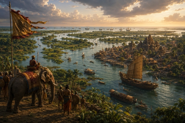
The Vanga Countryside in the Epic Age
Imagine approaching Vanga during the monsoon season. The sky is heavy with clouds, and the road repeatedly approaches broad rivers for which no permanent bridge exists. Boats wait at ferry points while carts and animals gather along muddy banks.
Beyond the crossing lie fields intensely green with cultivation. Villages occupy raised ground surrounded by ponds, channels and wetlands. Fishing boats move quietly between settlements, while merchants carry goods along waterways towards larger river markets.
Farther south, the country becomes increasingly tidal. Freshwater rivers begin responding to the sea, and forests occupy wetter tracts where permanent settlement is more difficult.
Somewhere within this complex water world stands the court of a Vanga ruler. Elephants captured or obtained from eastern forest regions are trained for warfare, royal envoys travel west along the Ganga corridor, and news arrives of Yudhishthira’s rising power at Indraprastha.
Eventually the ruler must deal with Bhima’s eastern campaign.
Later still, Vanga elephants march west towards Kurukshetra.
Vanga — The Kingdom Made by Rivers
Vanga occupies a particularly important position within Mahabharata geography because its epic references correspond so naturally with the physical character of Bengal. The Adi Parva preserves Vanga as one of the great eastern countries descended in legend from the line of Dirghatamas. Bhima enters Vanga during his eastern conquest, Vanga rulers attend Yudhishthira’s Rajasuya, Arjuna visits its sacred places, and Vanga elephant forces participate dramatically in the Kurukshetra War.
Vanga should therefore be placed broadly across central and southern Bengal, encompassing a substantial part of the deltaic country of modern Bangladesh and extending into adjoining southern West Bengal in India. Its strongest historical core can be visualised within the river country bounded broadly by the Bhagirathi system to the west and the Padma-Meghna world to the east, while recognising that its frontiers shifted considerably through different periods.
Vanga was not defined by mountains, deserts or a single walled capital. Its defining feature was the delta itself. Rivers created its fertile land, waterways provided its roads, monsoon floods shaped its settlements and the Bay of Bengal opened the region towards the maritime world. Its elephants gave it a distinctive military presence, while the lower Ganga connected its rulers to the political heartlands of northern India.
The Mahabharata therefore preserves Vanga as one of the great eastern components of Bharata: a distant but interconnected land whose rulers could stand in Yudhishthira’s court and whose elephant armies could thunder across Kurukshetra.
Across thousands of years, kingdoms have vanished and river channels have shifted repeatedly, yet the essential landscape remains recognisable. Vanga was the river kingdom of the Bengal delta, where the waters of northern India spread across a vast green plain before finally reaching the eastern sea.
You may also like
-
Shaka in the Mahabharata: Central Asia’s Steppe Peoples, Nakula’s Campaign and the Alliance with Duryodhana
-
Yavana in the Mahabharata: Greek Connections, Pandava Campaigns and the Warriors of Kurukshetra
-
India and Sri Lanka Launch SAMHiTA Manuscript Digitisation Project to Preserve Ancient Buddhist Heritage
-
ASI Uses Ground-Penetrating Radar to Investigate Ancient Buddhist Stupa at Ujjain After Nearly 90 Years
-
Pahlava: The Parthian World Beyond India’s Northwestern Frontiers in the Mahabharata
