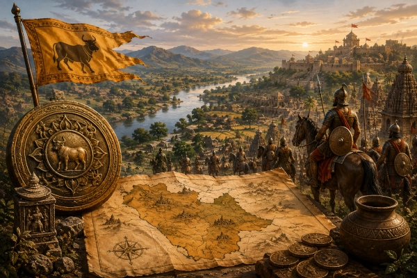
Kuntala was one of the important regions of ancient southern Bharat, occupying a broad part of the western Deccan that corresponds most closely with present-day northern Karnataka and adjoining southern Maharashtra. The country was associated with the upper Krishna River valley and with territories extending through parts of modern Karnataka and Maharashtra. Across different historical periods, the name Kuntala was applied to a somewhat changing geographical area, but its strongest and most enduring association remained with the Kannada-speaking western Deccan and the neighbouring districts of southern Maharashtra.
The Mahabharata explicitly remembers the Kuntalas among the peoples of Bharatavarsha. In one of the geographical descriptions of the Bhishma Parva, the Kuntalas occur among the peoples and provinces of ancient India, while another passage places them specifically among the kingdoms of the south alongside the Dravidas, Keralas, Vanavashikas, Karanatakas and other southern peoples. This provides an important textual basis for associating the principal Kuntala country with the Deccan.
Later literary and inscriptional evidence makes the identification considerably clearer. Historical geographers have placed Kuntala across southern Maharashtra and northern Karnataka, while inscriptions connect the country particularly with the upper Krishna valley. The region eventually became so closely associated with powerful Deccan dynasties that rulers of the area were sometimes styled Kuntaleshvara, or Lord of Kuntala.
Where Was Ancient Kuntala?
The core of ancient Kuntala lay in the western Deccan, particularly across northern Karnataka and adjoining southern Maharashtra. Historical reconstructions have associated the region with areas around modern Belagavi, Dharwad, Gadag, Vijayapura and adjoining parts of Karnataka, while its northern extension included portions of present-day Kolhapur, Sangli, Satara and Solapur in Maharashtra.
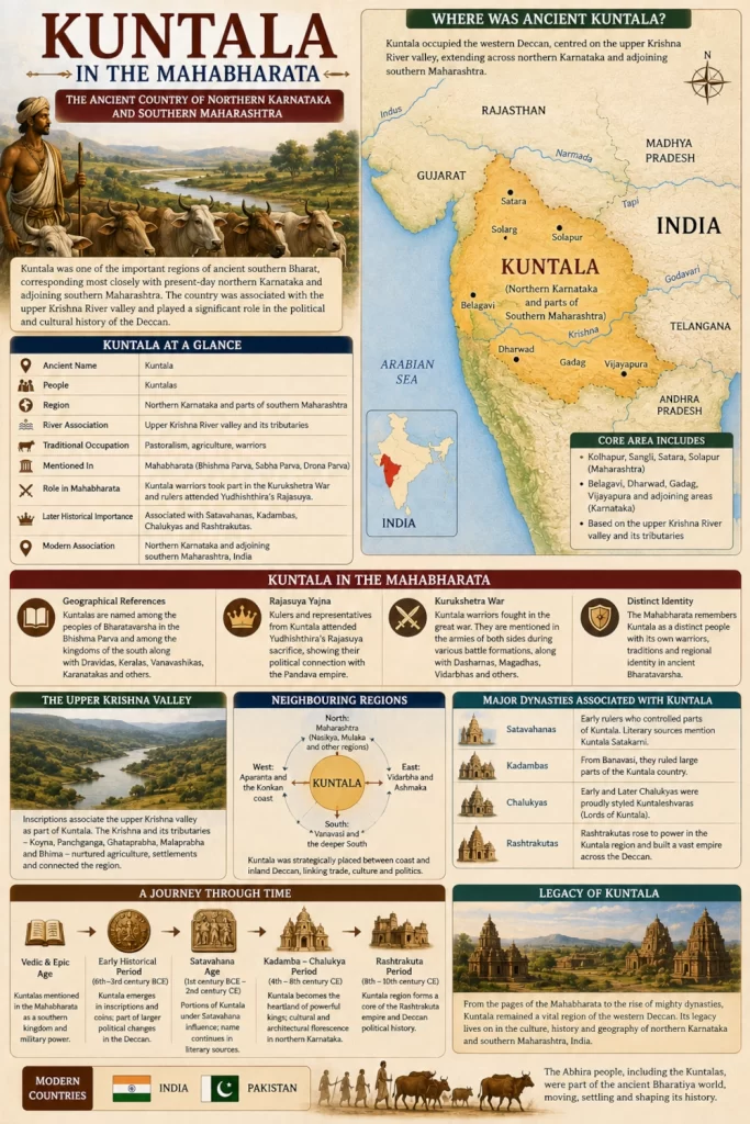
Some historical geographical studies assign an even larger territory to Kuntala at particular periods, extending it into parts of Ahmednagar, Beed and the older Mysore regions farther south. Such reconstructions should not be interpreted as permanent political boundaries. Kuntala changed in extent as kingdoms rose and fell, and the geographical meaning of the name evolved considerably over the centuries.
The most secure geographical feature is the upper Krishna River valley. An inscriptional reference identifies the upper Krishna valley as belonging to Kuntala, making the river one of the strongest anchors for reconstructing the ancient country. The Krishna and its tributaries created fertile agricultural corridors through the otherwise elevated and often dry Deccan plateau, supporting settlements and connecting the region with both Maharashtra and Karnataka.
The most useful modern identification is therefore Kuntala — northern Karnataka and adjoining parts of southern Maharashtra, India.
Kuntala in the Mahabharata
Kuntala is securely attested as a geographical name in the Mahabharata, although the epic preserves several references that are not always easy to reconcile with one another.
The Bhishma Parva includes the Kuntalas among the numerous peoples and provinces inhabiting Bharatavarsha. In another passage describing the kingdoms of southern Bharat, the text again names the Kuntalas, this time in a distinctly southern geographical setting alongside peoples such as the Dravidas, Keralas, Vanavashikas, Karanatakas and Mahishakas. This southern association agrees well with the historically documented Kuntala of the western Deccan.
The Kuntalas also appear in the military geography of the epic. A battle description associated with Drona places Kuntala warriors among forces that also included the Dasharnas, Magadhas, Vidarbhas and other peoples. This demonstrates that Kuntala was not merely a name appearing in an abstract geographical catalogue. Its warriors formed part of the military networks drawn into the great conflict at Kurukshetra.
The epic therefore remembers the Kuntalas both geographically and militarily. However, unlike kingdoms such as Matsya, Chedi or Magadha, the Mahabharata does not consistently centre Kuntala around a single famous ruler whose life dominates the narrative.
More Than One Kuntala in Ancient Texts
The ancient textual evidence contains an important complication. The name Kuntala does not always appear in exactly the same geographical context.
Historian Bimala Churn Law noted that Mahabharata and Purāṇic traditions appear to preserve references to Kuntalas in the Deccan, the western region and possibly even Madhyadesha. He therefore distinguished the historically important Deccan Kuntalas from other communities bearing a similar name. The Deccan Kuntalas are the group that later becomes clearly identifiable through inscriptions and political history.
This explains why an attempt to place every reference to Kuntala within one rigid boundary can create contradictions. Ancient ethnic and geographical names were often shared by related communities, transferred through migration or applied more broadly in different literary traditions.
For the historically important Kuntala discussed here, the strongest geographical identification remains the western Deccan encompassing northern Karnataka and southern Maharashtra.
Kuntala and Southern Bharat
The placement of Kuntala within southern Bharat is explicitly supported by the Mahabharata. In its description of the southern kingdoms, the Bhishma Parva names the Kuntalas among a large group that includes Dravidas, Keralas, Mushikas, Vanavashikas, Karanatakas and Mahishakas.
This ancient concept of the south should not be equated simply with the southernmost states of modern India. The dividing line between northern and southern geographical traditions often lay around the Vindhyas, Narmada or adjoining plateau regions. Much of Maharashtra and virtually the entire Deccan could therefore belong to Dakshinapatha or southern Bharat in ancient geographical classification.
Kuntala occupied the north-western part of this southern world. Its position placed it between Maharashtra to the north, the Karnataka plateau to the south and east, and the routes descending towards the Konkan and Arabian Sea to the west.
The Upper Krishna Valley
The Krishna River was one of the defining natural features of Kuntala. Rising in the Western Ghats of Maharashtra, the river flows eastward across the Deccan before eventually reaching the Bay of Bengal. Its upper valley passes through precisely the geographical belt historically associated with Kuntala.
This river system connected southern Maharashtra with northern Karnataka. Important tributaries such as the Koyna, Panchganga, Ghataprabha, Malaprabha and Bhima helped create a network of valleys and agricultural regions across the western Deccan.
The connection between Kuntala and the upper Krishna is supported by inscriptional geographical evidence. Historical studies specifically record that the upper valley of the Krishna was regarded as lying within Kuntala.
This makes the Krishna far more important for understanding Kuntala than any attempt to identify a single fixed capital for all periods.
The Western Ghats and the Deccan Plateau
Kuntala occupied a landscape shaped by the interaction between the Western Ghats and the Deccan plateau. The western edge of the region approached the Sahyadri ranges, beyond which the land descended towards the Konkan and the Arabian Sea.
Much of the interior consisted of elevated plateau country. Some areas possessed rich black soils suitable for agriculture, while others were drier and depended heavily upon seasonal rainfall and river systems.
The Western Ghats were not simply a barrier. Numerous passes connected the inland plateau with ports and settlements along the western coast. These corridors eventually became important routes for commerce, armies and political expansion.
Kuntala consequently occupied a strategic position between the maritime world of the Konkan and the enormous inland expanse of the Deccan.
Kuntala and Maharashtra
The northern part of Kuntala extended into what is now southern Maharashtra. Historical geographical studies commonly associate districts such as Kolhapur, Satara and Solapur with the wider Kuntala region, while other reconstructions include Sangli and adjoining territories.
Kolhapur and the upper Krishna-Panchganga country fit particularly naturally within this geographical framework. The region forms a continuation of the northern Karnataka plateau and possesses longstanding cultural and commercial connections across the modern Maharashtra-Karnataka boundary.
Ancient geography did not recognise the modern political border between Maharashtra and Karnataka. Regions such as Kuntala therefore extended across landscapes that today belong to different states.
This is one reason the ancient country should be understood through river valleys, plateaus and historical cultural zones rather than through modern administrative borders.
Kuntala and Northern Karnataka
Northern Karnataka formed the principal heartland of historical Kuntala. Belagavi, Dharwad, Gadag, Vijayapura and neighbouring regions lie within the broad zone most consistently associated with the ancient country.
Older inscriptional studies describe Kuntala as including places such as Belagavi, Harihar, Gadag, Lakkundi, Saundatti, Pattadakal and Aihole at different periods. The extent was not identical under every dynasty, but these references establish the deep connection between Kuntala and the northern Karnataka plateau.
The region later became one of the great political centres of the Deccan. The Kadambas, Early Chalukyas, Rashtrakutas and Later Chalukyas all controlled territories that had been associated with Kuntala, ensuring the survival of the name in inscriptions and literature for many centuries.
Kuntala and Vidarbha
Vidarbha lay to the north-east of the principal Kuntala country and formed another major ancient region of the Deccan. The two should not be treated as identical, although their political boundaries sometimes approached or overlapped during later historical periods.
The Mahabharata names both Kuntalas and Vidarbhas among the peoples of Bharatavarsha. In battle descriptions they can also appear within the same larger military formations, indicating that ancient tradition regarded them as distinct communities.
Later political history brought the two regions into repeated contact. Maharashtra’s historical records preserve references to conflicts between rulers of Kuntala and the Vakatakas of Vidarbha during the early centuries CE. The Vakataka king Harisena is recorded as having campaigned against a ruler of Kuntala, showing that the two regions remained politically distinct even when one sought dominance over the other.
Kuntala and Ashmaka
Ashmaka belonged principally to the Godavari valley farther north and east, while Kuntala occupied the western Deccan around the upper Krishna system. The two countries therefore formed neighbouring or near-neighbouring zones within ancient southern Bharat.
Purāṇic geographical lists sometimes place the Kuntalas alongside the Ashmakas and other Deccan peoples. This association reflects their common position within the wider southern geographical world rather than suggesting that they were the same kingdom.
Their relationship also illustrates the importance of river systems in ancient Deccan geography. Ashmaka was oriented strongly towards the Godavari, while the heartland of Kuntala was tied more closely to the Krishna and its upper tributaries.
Kuntala and Aparanta
To the west of Kuntala lay the Western Ghats and the territories descending towards the Konkan coast. These coastal regions were associated broadly with Aparanta and with smaller centres such as Surparaka farther north.
The Sahyadri mountain chain separated the inland plateau from the coast but did not isolate the two. Mountain passes allowed goods and travellers to cross between Kuntala and the Arabian Sea littoral.
This geographical relationship later became particularly important as Deccan powers sought access to western maritime commerce. Rulers controlling the plateau frequently competed for influence over the passes and coastal regions, linking the political history of Kuntala with that of Aparanta and the Konkan.
Kuntala and Vanavasi
Vanavasi, centred on ancient Vaijayanti or modern Banavasi in Karnataka, was closely connected with the wider historical geography of Kuntala.
The Kadambas established their kingdom around Banavasi and became one of the earliest major dynasties native to Karnataka. In later inscriptions, areas around Banavasi were described within the wider Kuntala country, demonstrating that the name could extend farther south than its northern Karnataka core during certain periods.
The Mahabharata itself lists Vanavashikas and Kuntalas separately among the southern peoples. This is an important reminder that the epic geography and later historical geography do not always employ territorial names in exactly the same way.
Over the centuries, however, the two geographical traditions became increasingly intertwined.
Kuntala at the Rajasuya
Kuntala also appears within traditions concerning Yudhishthira’s Rajasuya sacrifice. The Sabha Parva describes rulers and representatives arriving from numerous parts of Bharat to attend the imperial ceremony, and Kuntala appears among the names associated with those attending the gathering.
The Rajasuya brought together kingdoms from across northern, western, eastern and southern Bharat. The presence of Kuntala within this wider political assembly shows how the western Deccan was incorporated into the epic’s conception of an interconnected Indian political world.
The episode also demonstrates that distance did not prevent the southern kingdoms from participating in the diplomatic and ritual networks centred upon the great royal courts of northern India.
Kuntala Warriors at Kurukshetra
Kuntala warriors also appear in descriptions of the Kurukshetra War. During one of the battle formations associated with Drona, the Kuntalas are named alongside the Dasharnas, Magadhas, Vidarbhas, Mekalas and other contingents supporting the Kaurava military formation.
Another battle tradition describes the Pandya king fighting forces that included Kuntalas before his eventual confrontation with Ashvatthama. These references place warriors from the southern regions within the enormous multinational armies assembled at Kurukshetra.
The presence of Kuntalas in the war does not establish that every ruler or section of Kuntala supported the same side. Large ancient regions could contain several chiefs and political factions. The Mahabharata itself frequently records warriors from related peoples fighting on opposite sides.
What the references establish securely is that Kuntala belonged to the epic’s military as well as geographical world.
Kuntala in the Early Historical Period
Kuntala continued to be an important regional name long after the period represented in the Mahabharata.
Numismatic studies have attributed early punch-marked or regional coins to Kuntala, with some examples assigned broadly to the period between the sixth and fifth centuries BCE. The attribution of particular coin types has changed as numismatic scholarship has developed, but the evidence supports Kuntala’s emergence as an identifiable political region before the rise of many later Deccan dynasties.
Traditions also associate Kuntala with the expansion of the Nandas and eventually with the wider political transformations that incorporated much of the Deccan into larger imperial systems.
Even when the country ceased to exist as an independent political unit, its geographical name endured.
The Satavahanas and Kuntala
The Satavahanas became one of the dominant dynasties of the Deccan and at different times controlled large portions of the territory traditionally associated with Kuntala.
Literary traditions preserve the name Kuntala Satakarni, while later sources associate members of the Satakarni line with Kuntala. Bimala Churn Law noted that literary and epigraphic evidence indicates that Satakarni families controlled portions of Kuntala before the rise of the Kadambas.
This period demonstrates how the identity of Kuntala survived even when the region formed part of a much larger kingdom.
Instead of disappearing, the geographical name became attached to rulers and provincial identities within the changing political landscape of the Deccan.
The Kadambas and Kuntala
The rise of the Kadambas brought another important chapter in the history of the Kuntala region.
From their centre at Banavasi, the Kadambas established an influential kingdom in Karnataka. Later inscriptional traditions connect areas under their control with the wider Kuntala country, particularly in the Kannada-speaking districts of the western Deccan.
Their emergence is especially significant for the cultural history of Karnataka because the Kadambas represent one of the earliest major dynasties to establish political power from within the region itself.
The older geographical identity of Kuntala thus became integrated into the developing political and linguistic history of Karnataka.
The Chalukyas as Lords of Kuntala
Kuntala retained great prestige during the age of the Chalukyas.
The Early Chalukyas of Badami built one of the most powerful kingdoms of the Deccan during the sixth to eighth centuries CE. Their political heartland included Aihole, Badami and Pattadakal, all situated within the broader historical zone associated with Kuntala.
Later historical traditions refer to both the Early Chalukyas and the Later Chalukyas of Kalyani as Kuntaleshvaras, or Lords of Kuntala. The survival of this title demonstrates that Kuntala remained an important geographical and political concept centuries after its earliest literary appearances.
During this period, the region became one of the great centres of Indian temple architecture, Sanskrit and Kannada literature, administration and military power.
The Rashtrakutas and the Kuntala Country
The Rashtrakutas also became closely connected with Kuntala.
Before the rise of the imperial Rashtrakutas of Manyakheta, earlier Rashtrakuta families operated in parts of Maharashtra and the western Deccan. Historical inscriptions preserve references to rulers of Kuntala interacting and fighting with the Vakatakas of Vidarbha.
Later Rashtrakuta power extended across enormous portions of the Deccan, including the traditional Kuntala region. Their political history further strengthened the links between southern Maharashtra and northern Karnataka.
The repeated appearance of Kuntala under Satavahana, Kadamba, Chalukya and Rashtrakuta rule demonstrates how durable the geographical identity of the region was.
Kalidasa and the Lord of Kuntala
Kuntala also entered classical Sanskrit literary tradition through the famous story associated with Kalidasa and the Kuntaleshvara.
Fragments attributed to a lost work known as the Kuntaleshvaradautya preserve a tradition in which the Gupta emperor Chandragupta II sent Kalidasa as an ambassador to the court of the Lord of Kuntala. Later authors including Rajasekhara and Bhoja referred to episodes from this diplomatic mission.
The precise identity of the Kuntala ruler involved remains debated. Maharashtra’s historical scholarship has suggested that the king may have belonged to an early Rashtrakuta family rather than being a Vakataka ruler.
Whatever the exact identification, the tradition demonstrates the political importance attached to Kuntala during the classical period. A ruler described as Lord of Kuntala was important enough to maintain diplomatic relations with one of the greatest imperial courts of northern India.
Ancient Kuntala and Modern Geography
The heartland of ancient Kuntala corresponds most closely with northern Karnataka and adjoining southern Maharashtra. In Karnataka, the broad historical sphere includes areas around Belagavi, Dharwad, Gadag, Vijayapura, Bagalkot and parts of the older northern Mysore region. In Maharashtra, Kolhapur, Sangli, Satara and Solapur belong naturally to the northern extension of the Kuntala geographical zone.
The upper Krishna River provides the strongest natural axis linking these areas. The valleys of the Krishna and its tributaries created a geographical continuity across territory that today is divided between Maharashtra and Karnataka.
The historical boundaries changed repeatedly, and later uses of the name sometimes extended Kuntala considerably beyond this core. It is therefore more accurate to understand Kuntala as a broad western Deccan region rather than to impose a precise modern border upon it.
Kuntala and the Development of Karnataka
The later history of Kuntala became deeply intertwined with the development of Karnataka.
Historical records sometimes use Kuntala and Karnataka in closely related geographical senses. Medieval literary and inscriptional traditions increasingly connected Kuntala with the Kannada-speaking country, while the great dynasties ruling northern Karnataka inherited many of the political centres that had earlier belonged to the Kuntala geographical sphere.
This does not mean that Kuntala and modern Karnataka were always identical. Kuntala was generally smaller than the full extent of present-day Karnataka and often extended northward into Maharashtra.
It is better understood as one of the important ancient regional identities from which the later political geography of the western Deccan developed.
The Importance of Kuntala in Ancient Bharat
Kuntala’s importance came partly from its strategic geography. It occupied the great plateau between the western coast and the interior Deccan while controlling portions of the upper Krishna basin.
Routes westward crossed the Sahyadris towards the Konkan and Arabian Sea. Routes northward connected Kuntala with Maharashtra, Nasikya, Mulaka and the broader Godavari region. Eastern routes crossed the Karnataka plateau, while southern corridors continued towards Vanavasi and the deeper regions of the peninsula.
The same geography that made Kuntala important in ancient literature later helped transform northern Karnataka and southern Maharashtra into centres of powerful Deccan kingdoms.
Kuntala was therefore not a remote southern territory. It formed an important geographical bridge between northern and southern India and between the western coast and the interior peninsula.
The Legacy of Kuntala
Kuntala possesses one of the longest geographical histories among the ancient regions of the western Deccan.
The Mahabharata knew the Kuntalas as a recognised people of Bharatavarsha and explicitly included them among the kingdoms of the south. Kuntala warriors participated in the military world of Kurukshetra, while the region also appears within the political environment surrounding Yudhishthira’s Rajasuya.
In later centuries, the geographical identity became even clearer. The upper Krishna valley was recognised as Kuntala country, while Satavahanas, Kadambas, Chalukyas and Rashtrakutas became associated with territories carrying the ancient name. Rulers could proudly bear the title Kuntaleshvara, demonstrating the prestige that continued to surround the region.
The landscape itself explains much of this continuity. The Krishna and its tributaries connected fertile valleys across the plateau, while the Sahyadri passes opened routes to the western coast. Northern Karnataka and southern Maharashtra formed a natural geographical zone long before modern state boundaries divided them.
Kuntala therefore represents an important link between the epic geography of ancient Bharat and the later history of the Deccan. Its name survived through changing kingdoms, languages and dynasties, while the territory at its heart continued to produce some of the most influential political and cultural centres of southern India.
Kuntala was the ancient country of the western Deccan, centred principally upon northern Karnataka and extending into adjoining southern Maharashtra in present-day India.
You may also like
-
Ashmaka or Assaka in the Mahabharata: The Ancient Kingdom of the Godavari Valley
-
Rare Stone Features Emerge as Kerala Archaeology Department Restores Megalithic Kudakkals at Karivellur
-
Vidarbha in the Mahabharata: The Ancient Kingdom of Damayanti in Eastern Maharashtra
-
Abhira in the Mahabharata: The Pastoral People of Western India and the Northern Deccan
-
Nasikya in the Mahabharata World: The Ancient Nashik Region on the Upper Godavari
