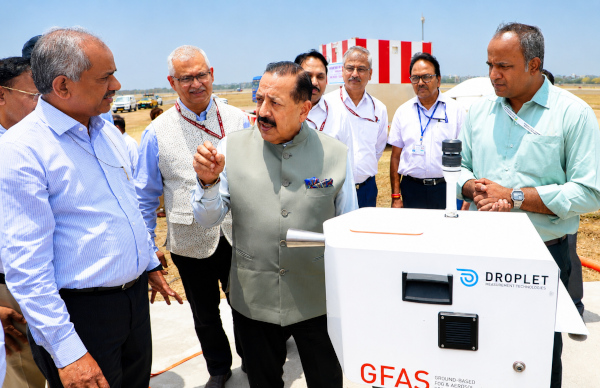
India has taken a major step towards safer, more reliable and weather-smart aviation with the inauguration of the country’s first SkyCast System at Indira Gandhi International Airport, New Delhi. Union Minister Dr. Jitendra Singh inaugurated the system on 29 May 2026, describing it as the beginning of a new phase in Indian aviation, where real-time atmospheric intelligence can help pilots, airlines and airport operators manage fog, turbulence and sudden weather disruptions with far greater precision.
SkyCast is important because aviation safety depends heavily on what happens in the lower atmosphere around an airport. Aircraft descent, final approach, landing and take-off are all sensitive to visibility, wind shear, turbulence, moisture, fog density and vertical atmospheric changes. Delhi’s airport faces some of the most difficult winter fog conditions in the country, where dense fog, pollution particles and low visibility can delay flights, divert aircraft and disrupt passenger movement. SkyCast brings these atmospheric details into one integrated monitoring framework.
According to the PIB release, India has now become the 19th country in the world to deploy such an advanced integrated aviation weather monitoring system. Dr. Jitendra Singh said only 18 such systems existed globally so far, and India’s installation at IGI Airport places the country among the select group using advanced remote-sensing infrastructure for aviation weather intelligence. The next SkyCast facility is planned for Jewar Airport, followed by wider expansion across other airports in India.
The system has been developed under Mission Mausam, the Government of India’s push to strengthen weather forecasting, climate services and advanced atmospheric observation. SkyCast is designed as a real-time aviation weather intelligence platform, combining multiple sensors and atmospheric instruments to help pilots and air traffic managers receive timely information during critical operating windows. The Minister said the system can provide advance alerts within short time windows of around three hours, helping aircrew choose safer landing windows and reduce unnecessary diversions, cancellations and delays.
At the heart of SkyCast is an advanced boundary layer Radar Wind Profiler. This instrument continuously measures wind speed, wind direction, turbulence, vertical velocity and boundary-layer behaviour up to nearly 3 kilometres above the airport. This layer of the atmosphere is extremely important for aviation because aircraft interact with it during climb, descent and landing. A sudden shift in wind or vertical motion near the runway can affect flight stability, landing approach and pilot decision-making.
SkyCast also includes SODAR, Microwave Radiometer, Ground-based Fog Aerosol Spectrometer and CL61 Lidar-based Ceilometer systems. Together, these instruments track fog, aerosols, moisture, visibility, turbulence and vertical cloud or fog structure. The Ground-based Fog Aerosol Spectrometer studies fog droplets and aerosol-fog interaction, which is especially relevant for Delhi, where pollution particles can influence fog formation and visibility. The Lidar-based Ceilometer monitors the vertical structure of fog, helping forecasters understand how fog builds, thickens, lifts and disperses.
This makes SkyCast more than a single airport instrument. It is an integrated atmospheric command system for aviation weather. Instead of relying on scattered observations, airport authorities can receive a fuller picture of runway-area weather in real time. Pilots, airlines, air traffic control and airport operators can use this data for nowcasting, route planning, runway operations and early warning decisions. For passengers, the long-term benefit could be fewer fog-related delays, smoother airport operations and safer flight schedules during difficult weather periods.
The scientific roots of SkyCast go back to the Winter Fog Experiment, known as WiFEX, which was jointly initiated by the Indian Institute of Tropical Meteorology and the India Meteorological Department under the Ministry of Earth Sciences at IGI Airport in 2015. WiFEX helped scientists understand fog formation, aerosol-cloud interaction, visibility reduction and urban boundary-layer processes. That research has now contributed to an operational system that can serve aviation directly.
The launch also fits into India’s broader aviation expansion story. India is rapidly increasing airport capacity, regional connectivity and passenger traffic. As air travel becomes more accessible, weather infrastructure has to grow alongside runways, terminals and aircraft fleets. Dr. Jitendra Singh connected SkyCast to the national vision of taking aviation from “Hawai Chappal to Hawai Jahaz,” while also emphasising the democratisation of weather services for the benefit of both aviation and citizens.
The system’s value extends beyond airports. Secretary, Ministry of Earth Sciences, Dr. M. Ravichandran said SkyCast will also strengthen India’s wider weather forecasting capabilities. Vertical profiles of wind, humidity and temperature generated through such advanced instruments can improve future forecast models. Under Mission Mausam, India is also expanding observational networks such as Doppler Weather Radars and similar advanced systems to improve monitoring of weather systems across the country.
Beyond aviation, SkyCast data can support artificial intelligence-enabled decision systems, urban weather forecasting, pollution management, transport advisories and disaster preparedness. This is an important point because atmospheric data collected around a major airport can also help scientists understand city-level weather behaviour, air pollution interaction, fog cycles and local climate risks. In a large urban region like Delhi-NCR, such information can support better planning across multiple public systems.
The inauguration ceremony was held at IGI Airport in the presence of senior officials from the Ministry of Earth Sciences, IMD, IITM, GMR and the aviation sector. Dr. Jitendra Singh inaugurated the SkyCast System and Fog Observatory facility at Glide Path 10, followed by a technical briefing and demonstration by IITM scientists.
SkyCast represents a strong example of Indian science moving from research to real-world deployment. It takes years of atmospheric research, converts it into operational technology and places it at one of India’s busiest airports. For a country with expanding aviation demand, complex weather patterns and rising passenger expectations, this is a timely infrastructure upgrade.
India’s first SkyCast system therefore marks a new phase in airport safety and weather intelligence. It brings together science, sensors, forecasting and aviation operations into one framework. As the system expands from Delhi to Jewar and then to other airports, it could become a key pillar of India’s weather-smart aviation network, helping the country reduce disruption, improve safety and build a more resilient air transport ecosystem.
Reference: PIB
You may also like
-
EON Space Labs and Dhruva Space Advance Indian Space Hardware on Transporter-18 Mission
-
SatLeo Labs’ TAPAS-1 Reaches Orbit, Advancing India’s Private Thermal-Imaging Capability
-
TakeMe2Space’s MOI-1A Reaches Space on Falcon 9 Transporter-18 Mission
-
Bank of Baroda Enters Pension Fund Management After PFRDA Appointment
-
SCI and India’s Push for a Larger Indigenous Maritime Fleet
