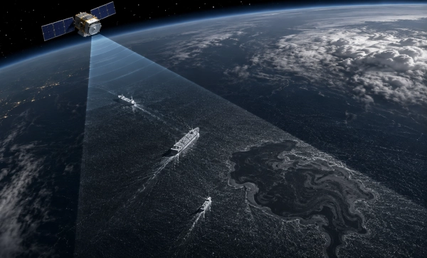
The oceans present one of the most difficult surveillance problems faced by modern states. Naval vessels, merchant ships, fishing fleets, offshore infrastructure and thousands of smaller craft are dispersed across enormous areas where shore-based radar coverage is limited and aircraft or patrol ships cannot maintain continuous presence. Optical satellites provide valuable imagery, but cloud cover and darkness can restrict what they can see. Automatic Identification System, or AIS, transmissions provide another layer of information, but they depend upon vessels broadcasting their position and identity correctly.
Ahmedabad-based PierSight is developing a different approach to this problem by combining Synthetic Aperture Radar, or SAR, with space-based ship-identification data in the same maritime intelligence architecture. The company is building a constellation intended to provide persistent, all-weather monitoring of maritime activity, allowing vessels, oil spills and other activity at sea to be detected through darkness and cloud cover and then correlated with AIS or its newer VDES evolution.
The significance of PierSight within the Make in India story extends beyond the construction of another Earth-observation satellite. The company is developing indigenous radar payload technologies, signal-processing systems, deployable antenna hardware and maritime-data fusion capabilities in India, while also participating in the country’s first public-private Earth-observation constellation approved by IN-SPACe.
The Maritime Surveillance Problem
Maritime domain awareness depends upon knowing what is happening across an area that covers most of the planet. Conventional coastal radars provide excellent information relatively close to shore, while ships and maritime patrol aircraft can investigate specific areas. Satellites dramatically increase geographical coverage, but different satellite sensors have different strengths and limitations.
Optical imaging satellites essentially photograph the Earth’s surface. Their imagery can provide considerable detail, but clouds, storms and darkness can prevent them from obtaining the required picture at the required time. This is especially problematic in tropical and monsoon regions, where persistent cloud cover can coincide with periods when maritime surveillance is particularly important.
Synthetic Aperture Radar approaches the problem differently. Instead of depending upon reflected sunlight, the satellite transmits microwave energy toward the Earth’s surface and measures the returned signal. Because the radar provides its own illumination, it can operate during both day and night. Microwave radar can also penetrate many types of cloud cover, giving SAR a major advantage for persistent observation of the oceans.
For a country such as India, which has extensive maritime interests stretching from the Arabian Sea through the Bay of Bengal and into the wider Indian Ocean, this capability has obvious strategic value.
SAR — Seeing Ships Through Darkness and Cloud
The physics of SAR makes it particularly useful over the ocean.
Ships provide strong radar reflections against the surrounding sea surface, while their wakes and movement can create additional signatures. Oil slicks can alter the roughness of the sea and consequently change the way radar energy is reflected back toward the satellite. This allows SAR imagery to contribute not only to ship detection but also to oil-spill monitoring and other forms of maritime environmental surveillance.
PierSight is designing its constellation around precisely these characteristics. The company says its architecture is intended to provide all-weather imaging, broad ocean coverage and much shorter intervals between observations than traditional Earth-observation systems. Its long-term objective is a constellation capable of producing actionable maritime information at approximately 30-minute revisit intervals.
The difference between a satellite image and a maritime-surveillance service is important. A single image can tell an analyst what was present at a specific moment. Persistent observation can begin to reveal movement, behaviour and anomalies.
A ship detected in one location becomes considerably more interesting when the system can determine where it was thirty minutes earlier, where it appears to be travelling and whether its electronic identity matches the physical vessel detected by radar.
Why AIS Alone Is Not Enough
Most large commercial vessels transmit information through the Automatic Identification System. AIS broadcasts data such as vessel identity, position, course and speed, allowing ships and maritime authorities to maintain situational awareness.
The weakness is that AIS is fundamentally a cooperative system.
A vessel that wishes to avoid attention can potentially switch off its transmitter, manipulate the information being broadcast or behave inconsistently with the identity it claims. Maritime surveillance based only upon AIS therefore contains an inherent blind spot: it sees most clearly the ships that agree to identify themselves.
SAR provides a useful independent check.
A radar satellite does not need the vessel’s cooperation. If a sufficiently large ship is physically present within the imaged area, the radar can potentially detect it even when its AIS transmitter is silent.
PierSight’s core concept is therefore to fuse the two information sources. SAR provides physical detection, while AIS provides identity and voyage information. When the two correspond, the system gains confidence in the vessel’s identity. When the radar detects a vessel for which no corresponding AIS signal exists, the object becomes a potential dark vessel requiring further investigation.
This data-fusion model is one of the most important aspects of PierSight’s architecture.
Finding the Ships That Do Not Want to Be Found
Dark-vessel detection has become increasingly important for navies, coast guards, fisheries authorities, insurers and sanctions-enforcement agencies.
A vessel may intentionally reduce its electronic visibility for several reasons. It may be conducting illegal fishing, attempting to circumvent sanctions, smuggling goods or engaging in activity that it does not wish authorities to observe. There can also be legitimate reasons for missing AIS information, so the absence of a signal does not automatically establish wrongdoing. Nevertheless, the mismatch between radar detection and cooperative identification provides an important investigative cue.
The value of SAR-AIS fusion therefore lies not merely in displaying ships on a map. It allows the system to identify inconsistencies between what vessels claim electronically and what satellites physically observe.
Academic research into space-based maritime surveillance has similarly highlighted the usefulness of combining satellite radar and AIS data for identifying vessels that are absent from conventional tracking systems.
For military and security applications, the same principle can contribute to a much broader recognised maritime picture.
Varuna — PierSight’s First Step Into Orbit
PierSight moved from laboratory development to space qualification with Varuna, its first in-orbit SAR technology demonstrator.
Varuna was launched on December 30, 2024, aboard the PSLV-C60 mission and operated through ISRO’s POEM-4 orbital platform. ISRO describes the payload as an in-orbit demonstration of Synthetic Aperture Radar in a CubeSat form factor and identifies PierSight Space of Ahmedabad as its developer.
The importance of Varuna lies primarily in the technologies that it was designed to validate.
According to ISRO, the payload incorporated seven advanced subsystems and was intended to test an indigenously developed reflectarray antenna, a Software-Defined Radar and Radio, a Solid-State Power Amplifier, antenna deployment mechanisms and an X-band radio for satellite data downlink.
These are not peripheral components. They represent some of the fundamental technologies required to build a compact radar-imaging satellite.
The Challenge of Putting Radar on a Small Satellite
Synthetic Aperture Radar is demanding technology for a small spacecraft.
A radar must transmit significant amounts of radio-frequency energy toward the Earth and then detect comparatively weak echoes returning from hundreds of kilometres below. This requires power electronics, precise timing, radio-frequency engineering, signal processing and an antenna capable of creating the required beam.
Large radar satellites traditionally use substantial antennas and relatively powerful spacecraft buses. PierSight’s engineering problem is to compress this capability into considerably smaller platforms without sacrificing the maritime surveillance performance required for commercial operations.
The reflectarray antenna tested through Varuna is particularly relevant to this objective.
A satellite must fit within the restricted volume available during launch, but a radar often benefits from a considerably larger antenna once it reaches orbit. Deployable structures therefore allow an antenna to be folded during launch and expanded after deployment.
By developing and flight-testing the antenna, deployment mechanism, radar electronics and radio systems in India, PierSight is accumulating engineering experience in technologies that have traditionally been concentrated among a relatively small number of established international satellite manufacturers.
Software-Defined Radar
Another important element of Varuna is the Software-Defined Radar and Radio, or SDRR.
Traditional radio and radar systems rely heavily upon dedicated hardware designed for particular waveforms and operating modes. Software-defined architectures move more of that functionality into programmable electronics and software.
This can make the satellite more adaptable.
Signal-processing algorithms can be modified. Radar modes can potentially be optimised for different operating conditions. Communications and processing functions can evolve without requiring the physical satellite hardware to be redesigned from the beginning.
For a start-up attempting to build a rapidly improving constellation, this flexibility can become strategically important. Spacecraft cannot be physically serviced easily once placed in orbit, so greater programmability can extend their usefulness and allow the operator to refine performance as experience accumulates.
From Varuna to a Commercial Constellation
Varuna was not intended to become the complete operational maritime-surveillance service by itself. It was a technology demonstrator designed to qualify the building blocks required for PierSight’s future satellites.
The company’s current website describes Varuna as operational and identifies it as an in-orbit SAR and AIS demonstrator. PierSight continues to list its first commercial SAR + AIS/VDES satellite as the next step toward a dedicated maritime constellation intended ultimately to achieve approximately 30-minute revisit times and broad ocean coverage.
PierSight previously identified this first commercial spacecraft as Varuna 2.0 and stated that the antenna design and manufacturing had been completed and was entering testing at ISRO’s Compact Antenna Test Facility.
The company’s public material continues to indicate a mid-2026 launch window for the commercial spacecraft. As of August 10, 2026, however, I could not find a public confirmation that this launch had actually taken place, so it is more accurate to describe the satellite as the company’s forthcoming commercial step rather than to assume that it is already in orbit.
AIS 2.0 and VDES
PierSight intends its commercial system to move beyond conventional AIS by incorporating VDES — the VHF Data Exchange System, which the company also refers to in this context as AIS 2.0.
VDES expands upon existing maritime VHF communications and is intended to support higher-capacity digital information exchange between ships, shore infrastructure and satellites.
For PierSight, the strategic value lies in putting radar imaging and vessel communications into a common space-based architecture. A satellite can potentially detect maritime activity through SAR while simultaneously receiving cooperative vessel data, reducing the amount of separate information that must later be assembled from unrelated systems.
This combination is central to the company’s claim that its constellation will provide maritime intelligence rather than simply radar imagery.
Vidura — Turning Satellite Data Into Maritime Intelligence
The commercial value of Earth-observation satellites increasingly lies not in the raw image but in the information extracted from it.
A coast guard officer, shipping company or naval operations centre does not necessarily want a radar image requiring specialist interpretation. The user wants to know which vessels are present, which ones are behaving unusually, where an oil spill is moving and which areas require immediate attention.
PierSight describes Vidura as the data-product layer intended to deliver fused, analysis-ready maritime information from its constellation.
This is where artificial intelligence and data processing become as important as spacecraft engineering.
Raw SAR imagery must first be processed into usable images. Ships must be detected. Their positions must be estimated. AIS or VDES records must be correlated with radar contacts. Historical behaviour can then be analysed for anomalies before information reaches the customer.
The complete commercial chain therefore becomes:
Spacecraft sensing → radar processing → vessel detection → AIS correlation → behavioural analysis → actionable maritime intelligence.
The company is consequently developing not merely satellites but a complete space-data business.
MATSYA and the Intelligence Layer
PierSight has also referred to MATSYA as part of its effort to convert large quantities of SAR and AIS data into maritime intelligence.
The objective is to build internal processing capability capable of examining large volumes of information for applications such as identifying illegal-fishing activity and mapping oil spills.
This distinction matters enormously in modern surveillance.
The fundamental scarcity is no longer always imagery. Governments and companies can already obtain enormous volumes of satellite, radar and tracking data. The real challenge is finding relevant activity within that information quickly enough for someone to act.
An algorithm that identifies an anomalous vessel minutes after a satellite pass can be considerably more operationally valuable than a perfect radar image delivered hours later.
Monitoring Illegal Fishing
Illegal, unreported and unregulated fishing is one of the principal commercial applications identified by PierSight.
Fishing fleets operate over enormous geographical areas, often beyond the range of regular coastal patrols. Aircraft and ships can investigate particular vessels, but maintaining constant physical surveillance across an entire Exclusive Economic Zone is extraordinarily expensive.
Satellite surveillance changes the economics.
SAR can search large maritime areas independently of daylight or cloud cover. AIS correlation can then identify vessels whose transmissions correspond with the radar contacts and highlight those that do not.
Persistent monitoring also allows behaviour to be examined over time. A vessel repeatedly turning off AIS around protected waters, rendezvousing with another ship at sea or operating in a restricted fishing area can generate an anomaly for closer investigation.
PierSight specifically identifies illegal fishing and EEZ monitoring among the principal applications for its constellation.
Oil Spills From Space
Oil-spill detection represents another significant application of SAR.
Oil floating on water can suppress small surface waves and change the texture of the ocean as observed by radar. Under favourable conditions, the affected region therefore appears differently from surrounding water in a SAR image.
Unlike an optical satellite, the radar does not have to wait for daylight and clear skies. This becomes particularly valuable during severe weather, when an oil spill may be expanding at precisely the time optical imagery is unavailable.
PierSight intends its persistent surveillance architecture to provide earlier detection and continuous monitoring, potentially giving coast guards, port authorities and environmental agencies more time to organise containment and response.
The same historical satellite archive could also help investigators reconstruct how a spill developed and identify vessels operating near the affected area.
Shipping, Ports and Insurance
Not every PierSight application is military or regulatory.
Commercial shipping companies can use persistent maritime information to improve awareness of vessel movements and congestion. Port operators can monitor approaches. Insurers can compare declared ship behaviour with independent satellite observations when investigating incidents or assessing exposure.
PierSight has consequently positioned the constellation as commercial maritime infrastructure rather than purely a defence system. Its target customers include shipping, insurance, port-management and ocean-conservation organisations as well as governments and coast guards.
This diversified market is important for the economics of private Earth observation. A satellite constellation is extremely expensive to build and maintain, and a company that can sell the same underlying data to defence, government, environmental and commercial customers has a much stronger business model than one dependent upon a single procurement programme.
A Potential Tool for Indian Maritime Domain Awareness
Although PierSight markets its system globally and for civilian applications, the underlying technology has obvious national-security relevance.
India’s maritime environment extends far beyond its coastline. Commercial shipping, naval deployments and strategic sea lanes across the Indian Ocean make persistent awareness increasingly important.
Traditional maritime-domain awareness combines coastal radar, vessel-reporting systems, patrol aircraft, ships, underwater sensors, intelligence sources and satellite data. A domestically controlled SAR constellation can add another independent layer to that architecture.
Its most important characteristic is persistence under conditions that degrade optical observation.
During the monsoon, during nighttime operations or when a suspicious vessel deliberately disables its cooperative transmitter, the radar layer remains available.
SAR should not be viewed as a substitute for maritime patrol aircraft, naval vessels or other sensors. Its value comes from cueing those expensive assets toward the areas that deserve investigation.
A satellite may detect the anomaly; a patrol aircraft or ship can then determine what the vessel is actually doing.
Sovereign Earth Observation Becomes a National Programme
PierSight’s strategic importance increased considerably in 2025 when it became part of the private consortium selected by IN-SPACe to establish India’s first Earth-observation constellation under a public-private partnership model.
The consortium is led by Pixxel and also includes Dhruva Space, SatSure Analytics India and PierSight Space. Government information released in 2026 confirms that the project has a four-year duration and that the consortium will establish and operate the EO satellite constellation under the PPP framework.
Within that consortium, PierSight has identified its role as providing the sovereign SAR backbone.
This is a major step beyond a start-up developing its own commercial satellite.
It places PierSight’s radar technology inside a national effort to expand India’s private Earth-observation capability and reduce dependence upon foreign sources for strategically important data.
Why Sovereign SAR Data Matters
Earth-observation sovereignty is not simply a matter of prestige.
During a crisis, a country dependent upon foreign commercial imagery may have to compete with other customers for satellite capacity. Data may arrive too slowly. Certain geographical areas or resolutions may be subject to restrictions. Access may also depend upon political relationships outside the user’s control.
A domestically operated satellite constellation changes that relationship.
India can determine which areas receive priority, how frequently they are observed and how the resulting data are distributed. Indian companies and government agencies can develop algorithms around a stable domestic data source rather than building critical services on top of imagery whose availability they do not control.
The Government has explicitly linked the PPP Earth-observation constellation with strengthening domestic capability across fields including disaster management, climate monitoring, agriculture and other national requirements.
For maritime applications, sovereign SAR coverage adds the further benefit of continuous observation irrespective of cloud or darkness.
PierSight and the New Indian Space Economy
PierSight is also a product of the larger restructuring of India’s space sector.
For decades, India’s advanced satellite capability was centred overwhelmingly around ISRO and government institutions. The opening of the sector to private companies has created a new generation of firms specialising in launch vehicles, propulsion, satellites, sensors, space situational awareness and downstream data services.
The Government stated in 2026 that India had grown to more than 400 space start-ups, with private investment exceeding $500 million and increasing numbers of non-government entities using ISRO facilities and POEM missions to qualify their technologies in space.
PierSight is a particularly good example of this new model because it uses government infrastructure without being merely a contractor manufacturing somebody else’s satellite.
The company develops its own payload technology, operates its own commercial roadmap and intends to sell data globally.
Using ISRO Infrastructure Without Surrendering Private Innovation
The Varuna programme demonstrates another important characteristic of India’s emerging private-space ecosystem.
A start-up does not need to build every piece of national space infrastructure independently. PierSight could develop its radar technology while using ISRO’s PSLV launch capability, POEM platform and specialised antenna-testing facilities.
ISRO’s POEM programme provides private companies with an opportunity to test technologies in the space environment without requiring each start-up to immediately finance a complete independent spacecraft mission.
Varuna used exactly this pathway. Its radar subsystems could be demonstrated in orbit, generating flight heritage that can subsequently be applied to commercial spacecraft.
This reduces one of the largest barriers facing space start-ups: the enormous expense and risk involved in obtaining the first successful flight.
India Building the Radar Technology Stack
The deeper Make in India significance of PierSight lies in the technology stack being developed around its satellites.
The Varuna programme included indigenous work on the reflectarray antenna, radar electronics, power amplification, antenna deployment mechanisms and X-band communications. PierSight is simultaneously developing the software required to transform radar echoes into usable imagery and then correlate those images with maritime identification data.
Taken together, these capabilities create an increasingly complete Indian SAR ecosystem:
Radar payload design, deployable antenna technology, RF power electronics, software-defined radar, satellite communications, SAR image formation, vessel detection, AIS/VDES fusion and maritime analytics.
This is substantially more valuable than importing radar imagery from another country’s satellite operator.
The capability to design the sensor means India can eventually optimise future satellites for Indian requirements rather than accepting whatever characteristics a foreign commercial constellation happens to provide.
The Economics of Smaller SAR Satellites
Traditional high-performance radar satellites have often been large and expensive systems. The new private-space model seeks to distribute the capability across larger numbers of smaller spacecraft.
The advantage is not simply lower individual satellite cost.
A larger constellation can revisit the same geographical area more frequently. For maritime surveillance, this can be more valuable than extremely high-resolution imagery obtained only occasionally.
A vessel may travel tens of kilometres between two widely separated satellite passes. Reducing the interval between observations makes it easier to reconstruct movement and identify anomalous behaviour.
PierSight therefore emphasises persistence and revisit frequency rather than treating image resolution as the only measure of satellite performance.
That philosophy is particularly well suited to the ocean, where the target itself is constantly moving.
From Satellite Imagery to an Ocean Operating Picture
The ultimate ambition behind PierSight is considerably larger than building a radar satellite.
The company is attempting to create a constantly updated digital picture of maritime activity.
Every satellite observation adds another layer of information. Radar detects physical objects. AIS and VDES provide identity information. Historical records reveal routes and behavioural patterns. Artificial intelligence can flag unusual activity. Oil-spill algorithms detect changes in the sea surface. The user eventually receives not a collection of separate satellite images but a continuously evolving representation of maritime activity.
This is the same transformation occurring throughout modern defence and intelligence systems.
Sensors are becoming data sources.
Data sources are being fused into networks.
And networks are increasingly generating operational decisions.
In that sense, PierSight’s most important product may ultimately not be its satellite at all. It may be the maritime intelligence layer created from the satellite constellation.
Made in India, Watching the World’s Oceans
PierSight’s development reflects the transition taking place within India’s private space sector. The country is moving from a model in which sophisticated Earth-observation capability belonged almost exclusively to government programmes toward one in which Indian companies design specialised satellites, own the intellectual property, process the resulting data and sell services internationally.
Varuna provided the first in-orbit demonstration of PierSight’s indigenous SAR technologies. The company’s commercial constellation is intended to combine radar observation with AIS and VDES identification, while its data-processing platforms seek to convert those observations into useful information for shipping companies, insurers, environmental organisations, coast guards and governments.
Its selection as the SAR partner in India’s private Earth-observation PPP gives this commercial ambition an additional strategic dimension. PierSight is no longer working only toward a private maritime-surveillance service; its technology is also becoming part of India’s effort to establish sovereign Earth-observation infrastructure under domestic control.
For India, that capability could eventually mean that a suspicious ship crossing the Indian Ocean, a vessel operating with its identification transmitter switched off, an oil spill developing beneath monsoon clouds or unusual activity inside an Exclusive Economic Zone can be observed by an Indian-built radar satellite, processed by Indian-developed software and delivered through an Indian-controlled intelligence network.
That is the deeper significance of PierSight within Make in India. It represents the emergence of a domestic private company attempting to place India’s maritime surveillance capability not merely on ships and aircraft, but hundreds of kilometres above the ocean — continuously watching through cloud, darkness and distance.
You may also like
-
AM Intelligence Orders 20,000 NVIDIA Rubin GPUs as India’s AI Compute Build-Out Accelerates
-
BEML Takes Indigenous Gaur Protected Vehicle to Australia for Land Forces 2026
-
India-UAE Exercise Mountain Guardian 2026 Begins at Chaubatia in Uttarakhand
-
Japan’s Semiconductor Companies Deepen India Footprint as Chip Ecosystem Advances
-
India and UAE Explore New Avenues to Expand Trade, Investment and Business Cooperation
