
The ancient region known as Lata or Lāṭa occupied a large part of what is now southern Gujarat, particularly the fertile country extending from the Mahi River toward the Narmada and Tapi river systems and the Gulf of Khambhat. Later historical records identify Lata as one of the major geographical divisions of Gujarat alongside Anarta and Saurashtra, with the important port of Bharuch forming one of the principal centres of the region.
Unlike Saurashtra, however, Lata requires special care when placed within a Mahabharata geographical series. Historical scholarship has long noted that the name Lata itself is not clearly found in the Mahabharata or the earliest Sanskrit literature. The name becomes securely visible in literary and epigraphic evidence during the early centuries of the Common Era. The territory that later became known as Lata certainly existed during the geographical world remembered by the epic, but the Mahabharata appears to describe western India through other regional identities, particularly Anarta, Aparanta, Surparaka and the sacred geography of the Narmada.
Lata should therefore be understood as a historically important ancient name for southern Gujarat whose geographical landscape overlaps with regions known to the Mahabharata, rather than as a kingdom that can confidently be assigned a named ruler or capital directly from the epic.
Where Was Ancient Lata?
The broadest and most widely accepted identification places Lata in southern and parts of central Gujarat. Older historical studies commonly describe it as the territory stretching from the Mahi River in the north toward the Tapi in the south, although its exact boundaries changed considerably over different periods.
Some records place the southern limit around the Narmada, while others extend Lata farther toward the Tapi, Purna or even the Damanganga. The western side opened onto the Gulf of Khambhat and Arabian Sea, while its eastern interior approached the uplands connecting Gujarat with Malwa and the Deccan. Epigraphic evidence also shows that the extent of Lata expanded and contracted according to political circumstances.
For a geographical reconstruction, the safest representation is therefore to show Lata broadly across the Bharuch–Vadodara–Surat belt of Gujarat, with the Mahi as an approximate northern reference and the Tapi as a useful southern reference. These should be treated as indicative geographical limits rather than rigid ancient political borders.
Lata at a Glance
Lata was an ancient historical region of western India corresponding broadly to southern Gujarat. Its territory was associated with the Mahi, Narmada and Tapi river systems and the eastern shore of the Gulf of Khambhat. Bharuch, ancient Bharukaccha and classical Barygaza, became one of the region’s most important commercial centres because of its position near the mouth of the Narmada.
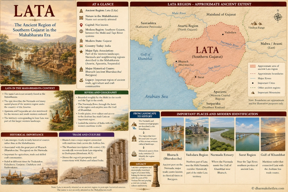
The region is securely documented in later ancient inscriptions and literature, but its name cannot presently be demonstrated with the same certainty in the Mahabharata itself. A historically responsible map should therefore identify it as “Lata — later ancient region of southern Gujarat; name not securely attested in the Mahabharata.”
Its modern geographical identification can be expressed broadly as Southern Gujarat → Bharuch, Vadodara and Surat region → India.
Why Lata Is Different from Saurashtra
Ancient Gujarat was not a single political or geographical unit throughout its history. Different names were used for different portions of the region, and their boundaries changed over time.
Saurashtra is associated principally with the Kathiawar Peninsula and is directly named in the Mahabharata. The epic records a ruler of Saurashtra, warriors from the region and Arjuna’s later journey through the country of the Saurashtras.
Lata is different. Historical research places it primarily in the mainland territory of southern Gujarat, east and south-east of the Saurashtra Peninsula. More importantly, the regional name becomes clearly attested considerably later than the epic’s geographical terminology.
This distinction should be preserved on a Mahabharata map. Saurashtra can confidently be shown as an epic geographical name, whereas Lata should be presented as the later historical name of the southern Gujarat landscape lying beyond the core Saurashtra Peninsula.
The Mahi River and the Northern Boundary
The Mahi River provides one of the most frequently cited northern reference points for Lata. The river flows through western India before entering the Gulf of Khambhat, creating a natural geographical division between portions of central and southern Gujarat.
Several historical reconstructions place Lata south of the Mahi, although particular dynasties sometimes controlled territory farther north. Epigraphic evidence from later centuries even places parts of the Kheda region within Lata, demonstrating how political usage could extend beyond the simplest geographical definition.
For mapping purposes, the Mahi therefore works best as an approximate boundary rather than an absolute frontier. Ancient regions usually followed political, ecological and cultural zones more loosely than modern state or district boundaries.
The Narmada at the Heart of the Region
The Narmada River is one of the defining geographical features of the Lata landscape. Flowing westward across central India, the river reaches the Arabian Sea through the Gulf of Khambhat near modern Bharuch.
The Narmada also provides an important connection between this later historical region and the Mahabharata. In the Vana Parva, the epic describes the sacred western landscape and gives extensive importance to the Narmada, presenting its banks as filled with tirthas, forests, hermitages and places visited by gods, sages and celestial beings.
Significantly, the passage introduces these western sacred places in association with Anarta rather than Lata. This strengthens the argument that the southern Gujarat landscape was known to the epic but was organised under geographical terminology different from that used in later centuries.
The Narmada consequently forms one of the best bridges between Mahabharata geography and historical Lata.
The Tapi and Southern Lata
The Tapi or Tapti River forms another major geographical marker. It flows westward through central India before reaching the Arabian Sea near modern Surat.
Many historical definitions place the southern extent of Lata near the lower Tapi, although some later political territories extended farther south. An early study of the Deccan, for example, describes Lata as the province between the Mahi and lower Tapi, while later epigraphic interpretations reveal considerable variation in its exact limits.
The presence of the Narmada and Tapi made southern Gujarat particularly fertile and commercially important. Both rivers provided routes connecting the interior of India with the western coast, allowing agricultural products, textiles and other commodities to move toward maritime ports.
Bharuch: The Great Port of the Lata Region
No city is more important to the historical geography of Lata than Bharuch, located near the mouth of the Narmada.
Ancient sources refer to the settlement under forms such as Bharukaccha, Bhrigukaccha and Barygaza. Its position gave merchants access both to the Arabian Sea and to riverine and overland routes leading deep into the Indian interior.
By the early historical period, Bharuch had become one of western India’s great commercial ports. Traders passing through the city connected Gujarat with ports across the Arabian Sea while inland routes linked it with Malwa, central India and the Deccan. Archaeological and historical studies consequently regard Bharuch as a major commercial centre of the wider Lata region.
For a location map, Bharuch should be one of the principal modern reference points, although it would be safer to call it an important historical centre of Lata rather than declare it the capital of a Mahabharata-era Lata kingdom.
Was Bharuch the Capital of Lata?
Later historical traditions frequently associate Bharuch closely with Lata, and several political dynasties ruling southern Gujarat operated from the Bharuch-Narmada region. This has sometimes led to Bharuch being described broadly as a capital or principal city of Lata.
The evidence, however, belongs mainly to periods much later than the Mahabharata. Different dynasties controlled different portions of southern Gujarat, and centres of political authority changed through time.
For a historically careful Mahabharata-geography article, the best entry is therefore “Major historical centre: Bharuch; Mahabharata-era capital not known.” This avoids projecting later political arrangements backward into the epic.
The Mahabharata Does Not Clearly Name Lata
This is the most important textual point.
The nineteenth-century History of Gujarat explicitly observed that the name Lata had not been found in the Mahabharata or other very early Sanskrit works and that secure occurrences emerge only later. Modern historical studies of Gujarat have repeated the same caution.
That absence does not mean southern Gujarat was uninhabited or unimportant during the cultural period reflected in the epic. It simply means that the regional terminology was different.
Ancient geographical names evolved just as modern political names do. A region that later became widely known as Lata may earlier have been understood as part of another cultural or geographical zone.
The correct historical approach is therefore to distinguish between the landscape and the later name applied to that landscape.
Anarta and the Narmada in the Mahabharata
The Vana Parva provides an important clue to the epic’s understanding of western India. While describing sacred places in the west, Dhaumya introduces the country of the Anartas and immediately describes the westward-flowing Narmada with its numerous sacred places.
This does not prove that all of later Lata belonged politically to Anarta. Ancient territorial descriptions were rarely so precise. It does, however, demonstrate that the Mahabharata’s western geography associated the Narmada landscape with terminology other than Lata.
This is especially useful for this geographical series because it prevents the modern map from creating false certainty. On a reconstruction, Anarta and Lata should not simply be drawn as simultaneous fixed states with modern-style borders.
Instead, Lata can be explained as a later regional identity that developed across territory whose earlier epic geography involved Anarta and the broader western coastal world.
Aparanta and the Western Seaboard
Another important Mahabharata geographical term is Aparanta, literally associated with the western extremity or western coastal region.
The Mahabharata uses Aparanta in connection with the western seaboard and with the legendary territory associated with Parashurama. Later geographical traditions employ the name for portions of India’s western coast, especially territory extending southward toward the Konkan.
Some historians have suggested that before Lata emerged as a clearly attested regional name, broader designations such as Aparanta may have covered portions of the western coastline south of the Narmada.
The relationship should not be made too rigid, but it demonstrates again that the geographical area later called Lata existed within a much older network of western Indian regional identities.
Surparaka and the Southern Coastal World
The Mahabharata also knows Surparaka, a famous western tirtha associated with Parashurama. The Shanti Parva relates that the ocean created the region of Surparaka for Jamadagni’s son after Kashyapa instructed him to leave the land he had given away.
Surparaka is traditionally identified with Sopara in the northern Konkan near modern Mumbai, placing it south of the main Lata heartland.
This is geographically important because the historical southern boundary of Lata sometimes approached the northern Konkan. The two regions belonged to an interconnected coastal system of ports, river mouths and trading settlements extending south from Gujarat.
Lata therefore occupied a strategic position between the western Gujarat world of Anarta and Saurashtra and the coastal territories extending toward Aparanta and Surparaka.
The Earliest Clear Historical Evidence for Lata
Although Lata is absent as a securely attested Mahabharata name, it becomes increasingly visible in early historical sources.
Scholars have associated the Larike described by the second-century geographer Ptolemy with Lata. Ptolemy’s geography places the famous port of Barygaza, or Bharuch, within this western Indian region. The identification is not based on the Mahabharata but demonstrates that a recognisable regional identity resembling Lata existed by the early centuries CE.
Later Sanskrit and inscriptional evidence becomes much clearer. By the Gupta period, Lata appears as an established geographical designation, and subsequent dynasties repeatedly refer to Lata-desha, Lata-vishaya and related administrative territories.
The region therefore belongs firmly to the history of ancient India even if its name cannot safely be pushed backward into the Mahabharata text.
The Mandasor Silk Weavers from Lata
One of the most fascinating references to Lata comes from the famous Mandasor inscription of the silk weavers, dating to the fifth century CE.
The inscription records that a guild of skilled silk weavers migrated from Lata to Dashapura, modern Mandsaur in Madhya Pradesh. It describes Lata as a beautiful region containing flowering trees, temples, assembly halls and religious establishments.
The inscription is extremely valuable because it reveals something about the economic and cultural character of Lata. The region was not merely an administrative territory. It contained skilled artisan communities capable of moving across long distances and maintaining organised guild structures.
The migration from southern Gujarat toward Malwa also demonstrates the strong connections linking Lata with the inland trade routes of western and central India.
Lata and the Textile Economy
The silk-weaver inscription suggests that textile production formed an important part of the economic life associated with Lata.
Gujarat would later become famous across the Indian Ocean world for its textiles, but the Mandasor evidence demonstrates that specialised weaving communities were already associated with Lata in late antiquity.
The region’s geography was favourable to commercial development. River valleys connected it with central India and the Deccan, while the Gulf of Khambhat opened directly onto maritime routes.
Bharuch provided an outlet through which goods from the interior could reach overseas markets. Lata therefore occupied one of the natural gateways between inland India and the Arabian Sea.
A Land Between River and Sea
The physical geography of Lata played a major role in its history. The region contained fertile alluvial and black-soil plains watered by several major west-flowing rivers, particularly the Mahi, Narmada and Tapi.
To the west lay the Gulf of Khambhat, whose powerful tidal system created both challenges and opportunities for ancient shipping. To the east, routes climbed toward Malwa, the Narmada valley and the Deccan plateau.
This gave Lata a geographical character quite different from the peninsula of Saurashtra. Saurashtra projected outward into the Arabian Sea, while Lata occupied the mainland corridor through which river valleys and land routes reached the coast.
The two regions together formed complementary parts of ancient Gujarat’s western landscape.
Lata’s Relationship with Malwa
Lata’s connections with Malwa were particularly strong. The migration of silk weavers from Lata to Dashapura is one clear example, but geography itself encouraged such movement.
Routes following the Mahi and Narmada systems allowed people and goods to move between Gujarat and central India. The plateau of Malwa lay east and north-east of Lata, while Avanti and its surrounding regions formed some of western India’s major political and commercial centres.
Later literary descriptions accordingly place Lata west of Malwa. This relationship helps situate the region on a broader ancient map: Saurashtra lay toward the western peninsula, Malwa and Avanti toward the east and north-east, while the northern Konkan and western Deccan lay to the south.
Lata Under Later Dynasties
Lata became increasingly prominent as a political name during the early medieval period.
The region passed through the influence or control of several dynasties, including the Traikutakas, Kalachuris, Gurjaras, Chalukyas and Rashtrakutas. Its strategic value came from its fertile territory, river crossings and access to the western maritime trade.
By the Rashtrakuta period, inscriptions explicitly describe Lata as an important province. Historical evidence records Govinda III assigning Lata to his brother Indra, whose descendants became associated with a regional Rashtrakuta branch.
These developments occurred many centuries after the world described by the Mahabharata, but they demonstrate how the geographical identity of southern Gujarat eventually crystallised into a major political region.
Lata, Saurashtra and Anarta
For understanding ancient Gujarat, three names are especially useful: Anarta, Saurashtra and Lata.
Saurashtra is most strongly associated with the Kathiawar Peninsula. Lata became associated with southern mainland Gujarat. Anarta is generally connected with northern and western Gujarat, although its extent varies considerably between sources and periods.
The problem is that these names did not necessarily refer to the same fixed territories at all times. Ancient writers could use them differently, political boundaries changed, and some traditions overlap geographically.
A reconstructed map should therefore avoid the appearance of exact modern frontiers. The objective is to show approximate cultural and political regions, not to reproduce a modern administrative map in ancient colours.
Ancient Lata and Modern Gujarat
The landscape associated with Lata today covers some of Gujarat’s most economically important territory.
Bharuch lies on the Narmada near its estuary. Vadodara stands farther north within the Mahi-Narmada corridor. Surat lies near the Tapi and became one of India’s greatest ports during later historical periods. Other modern reference points include Ankleshwar, Navsari and parts of the Gulf of Khambhat coast.
A modern reader looking at this region should understand that historical Lata occupied the mainland belt of southern Gujarat between the cultural worlds of Saurashtra to the west, Malwa toward the interior and the northern Konkan farther south.
Important Places and Modern Identification
Bharuch should form the primary historical centre of the article because of its position at the Narmada estuary and its enormous importance in ancient maritime commerce. Classical writers knew it as Barygaza, while Indian traditions preserved forms such as Bharukaccha and Bhrigukaccha.
Vadodara provides a useful modern reference for the northern portion of the Lata geographical zone, especially because later epigraphic evidence sometimes extended Lata toward Kheda and neighbouring parts of central Gujarat.
Surat is the best modern reference for the lower Tapi region. Although Surat’s greatest historical prominence came much later, its location helps readers understand the southern geographical extent commonly assigned to Lata.
The Narmada estuary and Gulf of Khambhat should also be treated almost as locations in their own right because they explain why this region became such an important bridge between inland trade and maritime commerce.
Lata in the Wider Mahabharata Landscape
Although Lata cannot be confidently listed among the kingdoms explicitly named in the Mahabharata, its territory lies within an unquestionably important part of the epic’s western geographical world.
To the west stood Saurashtra, whose ruler Akriti and warriors are directly mentioned in the epic. To the north and north-west lay the broader territory associated with Anarta and the Yadavas. The Mahabharata describes the sacred Narmada in this western setting, while farther south the text knows the coastal region associated with Aparanta and Surparaka.
The later region of Lata developed within this same geographical corridor.
It therefore deserves a place in a wider reconstruction of ancient Bharat, but its placement must distinguish direct Mahabharata evidence from later historical evidence.
Why This Distinction
Ancient Indian geographical reconstruction becomes less reliable when names from different centuries are placed on a single map as if they all existed simultaneously with fixed boundaries.
Lata provides a particularly useful example. Its later historical identity is unquestionable, and its approximate location in southern Gujarat is well established. Yet its absence as a secure Mahabharata name tells us that the geographical vocabulary of western India changed through time.
Preserving that distinction does not weaken the connection with ancient India. It actually makes the reconstruction more credible.
The region’s rivers, coast and settlements existed long before the name Lata became common. What changed was the terminology through which people described and administered the landscape.
From the Mahabharata’s Narmada to Historical Lata
The most useful way to understand Lata within our Mahabharata geography series is therefore through continuity of landscape rather than continuity of name.
The Mahabharata knew the Narmada, western sacred places, Anarta and the wider coastal world. Centuries later, inscriptions and literary sources increasingly called a large part of this southern Gujarat landscape Lata.
The Mandasor inscription then provides a vivid glimpse of Lata as a flourishing region whose skilled silk weavers travelled to Malwa. Later dynasties fought for control of the same territory because its agricultural wealth and trade routes made it strategically valuable.
The geographical landscape remained important even as its political names changed.
The Legacy of Lata
Lata eventually became one of the enduring geographical names of ancient and early medieval western India. Its location around the Narmada, Tapi and Gulf of Khambhat placed it at the intersection of some of India’s most important inland and maritime routes.
Bharuch connected the region to overseas commerce, while the Narmada corridor linked the coast to central India. Skilled artisan communities such as the silk weavers recorded in the Mandasor inscription demonstrate the movement of people and technology between Lata and Malwa. Later rulers repeatedly competed for the territory because whoever controlled southern Gujarat gained access to both fertile land and maritime trade.
For a Mahabharata geographical reconstruction, however, Lata’s greatest value lies in demonstrating that ancient Indian regions evolved across time. The land later known as Lata clearly formed part of the western world known to the epic, particularly through the sacred geography of the Narmada, but the regional name itself belongs to a later and better documented historical period.
The most accurate modern identification is therefore Lata → southern Gujarat, particularly the Mahi–Narmada–Tapi corridor → India.
Seen in this way, Lata becomes an important bridge between the landscape of the Mahabharata and the political geography of later ancient India. It reminds us that the rivers, ports and trade routes of Gujarat possessed a much longer history than any single kingdom name, while also showing why southern Gujarat would remain one of western India’s most strategically and economically important regions for centuries.
You may also like
-
Yavana in the Mahabharata: Greek Connections, Pandava Campaigns and the Warriors of Kurukshetra
-
India and Sri Lanka Launch SAMHiTA Manuscript Digitisation Project to Preserve Ancient Buddhist Heritage
-
ASI Uses Ground-Penetrating Radar to Investigate Ancient Buddhist Stupa at Ujjain After Nearly 90 Years
-
Pahlava: The Parthian World Beyond India’s Northwestern Frontiers in the Mahabharata
-
Namami Gange in 2026: 368 Projects Completed, 4,339 MLD Sewage Treatment Capacity Created as Ganga Rejuvenation Advances
