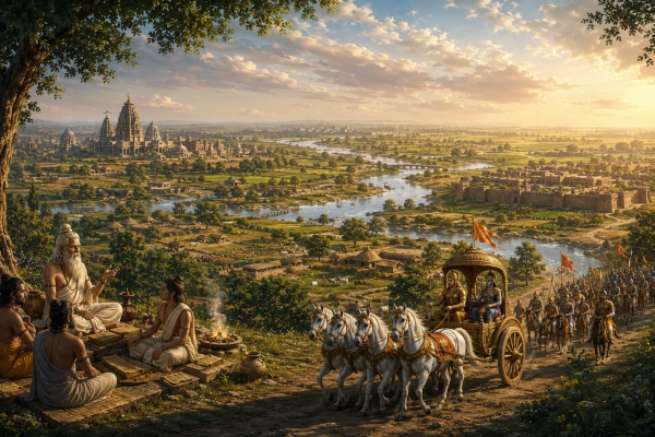
The ancient land of Kuru occupies a central position in the geographical, political and spiritual history of Bharat. Spread broadly across present-day Haryana, Delhi and the upper western districts of Uttar Pradesh, it formed the principal setting of the Mahabharata and emerged as one of the most influential centres of later Vedic civilisation.
Kuru was more than the territory of a royal dynasty. It was a fertile riverine region in which clans were consolidated into an organised state, Vedic rituals were systematised, political authority became more structured and traditions that shaped later Indian civilisation acquired a durable form.
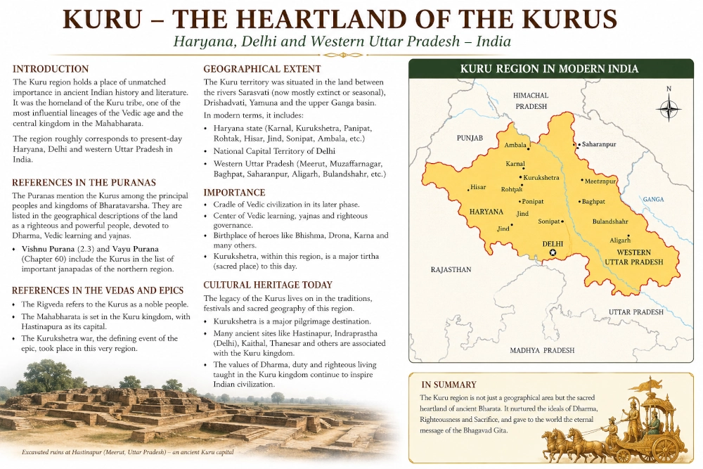
The modern states and boundaries seen on a map did not exist during the Vedic or epic periods. Nevertheless, historians generally place the Kuru heartland across central and eastern Haryana, the Delhi region and the upper Ganga–Yamuna Doab of western Uttar Pradesh. Academic descriptions connect the Kurus particularly with the Haryana–western Uttar Pradesh region, while broader reconstructions extend their sphere between the Sarasvati-related plains in the west and the Ganga in the east.
The Location of the Kuru Country
In modern geographical terms, the Kuru country can be understood through three connected zones:
The Haryana plains, including Kurukshetra, Kaithal, Karnal, Panipat and Sonipat;
The Delhi region, traditionally associated with Indraprastha and the southern part of the Kuru domain;
Western Uttar Pradesh, particularly the upper Ganga–Yamuna Doab extending towards Baghpat, Meerut and Hastinapur.
One academic reconstruction describes the Kuru Mahajanapada as including the Haryana districts of Kaithal, Thanesar, Karnal, Panipat and Sonipat, together with adjoining Uttar Pradesh as far as the Ganga near Hastinapura.
This geographical spread gave the Kurus access to some of northern India’s most productive alluvial plains. The territory lay across major routes connecting the northwestern regions of the subcontinent with the Ganga Valley. Its rivers, seasonal streams, grasslands and fertile soil supported agriculture, cattle-rearing, settlements, royal centres and ritual communities.
The Kuru landscape was therefore both strategically placed and economically valuable.
Kurukshetra: The Sacred Northern Heartland
Kurukshetra was one of the most important parts of the Kuru country. Its name literally means the “field of Kuru” or the “land of the Kurus.”
The sacred region was associated with the plains around modern Thanesar and Kurukshetra in Haryana. Later tradition remembered it as a vast pilgrimage landscape rather than merely a single battlefield. The Haryana government describes the traditional Kurukshetra region as a sacred area extending across forty-eight kos and containing numerous pilgrimage sites, temples and sacred water bodies.
Kurukshetra’s importance was older and broader than the Mahabharata war alone. It was remembered as a land of sacrifice, Vedic learning, pilgrimage and religious merit. The Bhagavad Gita opens by calling it Dharmakshetra Kurukshetra—Kurukshetra, the field of dharma.
The landscape was traditionally connected with the ancient Sarasvati and Drishadvati river systems. Government accounts of the region preserve the tradition that the sacred tract lay between these two rivers.
This made northern Kuru not simply a political territory but one of the most important ritual landscapes of ancient Bharat.
Indraprastha and the Delhi Region
The southern section of the Kuru country centred upon the region of modern Delhi.
The Mahabharata describes Indraprastha as the capital established for the Pandavas after the division of the Kuru realm. Tradition associates the city with the area around present-day Delhi, especially the zone near Purana Qila and the Yamuna.
Indraprastha’s location reflects the geographical importance of Delhi even in antiquity. The region stood near routes leading westwards towards Haryana and Punjab, eastwards into the Ganga plains and southwards towards Rajasthan and central India.
Control of this zone allowed rulers to oversee movement between several major cultural and economic regions.
The Mahabharata presents Indraprastha as a prosperous, carefully planned royal capital. Whether every architectural detail in the epic is read historically or symbolically, the tradition strongly associates Delhi with the political geography of the Kurus.
Hastinapura and the Upper Ganga Plain
To the east of Delhi lay Hastinapura, traditionally remembered as the principal capital of the Kuru kings.
Modern Hastinapur is situated in the Meerut district of Uttar Pradesh near the Ganga. The city occupies an important position in both Hindu and Jain sacred traditions. In the Mahabharata, it is the royal seat of Shantanu, Bhishma, Dhritarashtra, Pandu and the Kauravas.
Its location near the Ganga placed it within the fertile upper Ganga plain and connected it with routes extending farther east into Panchala, Kosala and other regions of northern Bharat.
The Kuru territory therefore did not stop at Delhi or the Yamuna. Its eastern sphere extended into the upper Doab and towards the Ganga, where Hastinapura functioned as an important royal and cultural centre. Academic geographical reconstructions accordingly include the adjoining western Uttar Pradesh region up to the Ganga within the Kuru domain.
The Rivers of the Kuru Landscape
The geography of Kuru cannot be understood without its rivers.
The Yamuna ran through the broader region and connected Delhi with the upper plains.
The Ganga formed the great eastern river system near Hastinapura.
The Sarasvati and Drishadvati traditions shaped the sacred geography of Kurukshetra and the western plains.
Several smaller rivers, seasonal channels and tributaries nourished settlements throughout Haryana and the upper Doab.
These waters produced a landscape suitable for agriculture and pastoral life. Barley, wheat and other crops could be cultivated on the plains, while cattle remained economically and ritually important.
The river system also linked the region to larger movements of people, goods, religious ideas and political influence.
Kuru-Jangala and Kuru Proper
Ancient texts and later geographical traditions sometimes distinguish between different parts of the Kuru country.
Kuru-Jangala generally referred to the drier or more wooded western portion, associated broadly with parts of Haryana.
Kuru Proper was connected more closely with the territory towards Delhi, the Yamuna and the upper Ganga–Yamuna Doab.
These divisions were not equivalent to modern states or districts. Their boundaries probably shifted according to political power, settlement patterns and environmental conditions.
The distinction nevertheless reflects the varied geography of the Kuru realm. The west included plains influenced by seasonal and disappearing river systems, while the east opened towards the more continuously watered Ganga–Yamuna region.
This environmental diversity helped make Kuru a bridge between the older northwestern Vedic world and the expanding cultural centres of the Ganga plain.
From Clan Territory to Vedic State
The rise of the Kurus marked an important stage in the political development of ancient northern India.
Scholar Michael Witzel describes the formation of the Kuru realm as a development of extraordinary importance because Kuru civilisation strongly influenced later Indian ritual, society and political formations. He places the ancient Kuru people broadly in the Haryana and western Uttar Pradesh region.
Earlier Vedic society was organised largely through clans and tribal groupings. Under the Kurus, political authority became more consolidated. Kingship, priestly institutions and major rituals became closely linked.
The Kuru realm helped create a stable environment in which different Vedic traditions could be collected, reorganised and transmitted. The region became a major centre of the later Vedic world.
This is why Kuru history is important beyond the Mahabharata narrative. The Kurus stand at the transition between the clan-based society of the earlier Vedic period and the territorial states that later emerged across northern India.
Kuru and Panchala
To the east and southeast of the Kurus lay the territory of Panchala, covering parts of present-day western and central Uttar Pradesh.
Kuru and Panchala were sometimes political rivals, but they also became closely connected cultural regions. Later Vedic literature frequently treats the Kuru-Panchala area as a major centre of ritual learning and intellectual activity.
Together, the two regions occupied much of the upper Ganga–Yamuna plains. Their courts and scholarly communities contributed greatly to the development of Vedic thought, sacrifice, social institutions and political ideas.
The Kuru-Panchala zone became one of the principal centres from which Vedic culture expanded farther east into Kosala, Videha and Magadha.
Archaeology of the Kuru Region
Archaeologists have identified numerous ancient settlement zones across Haryana, Delhi and western Uttar Pradesh.
One major archaeological survey conducted by the University of Cambridge examined two areas directly relevant to Kuru geography: the central Haryana plains and the region northeast and east of Delhi in western Uttar Pradesh. The surveyed zones included districts along the Yamuna, Hindon, Ghaggar, Sarsuti and Chautang river systems.
Many sites in the broader Kuru-Panchala region have yielded Painted Grey Ware, a ceramic tradition associated with Iron Age settlements in northern India.
Painted Grey Ware does not independently prove that every event narrated in the Mahabharata occurred exactly as described. It does, however, demonstrate the presence of organised settlements and a developing material culture across the geographical world associated with the Kurus.
Archaeology and literature therefore illuminate different aspects of the same broad landscape. The texts preserve dynastic, ritual and cultural memory, while excavations reveal settlement patterns, pottery, habitation layers and environmental adaptation.
Important Places in the Modern Kuru Region
Several modern places preserve the geographical memory of the Kuru country:
Kurukshetra, Haryana
The sacred field associated with the Mahabharata war and the Bhagavad Gita. Important sites include Jyotisar, Brahma Sarovar and Sannihit Sarovar.
Thanesar, Haryana
An ancient settlement closely connected with the greater Kurukshetra region.
Kaithal, Haryana
Located within the broader traditional Kuru and Kurukshetra landscape.
Karnal, Haryana
Part of the fertile plains linking Kurukshetra with Panipat, Sonipat and Delhi.
Panipat, Haryana
Situated along the historic north–south route between Kurukshetra and Delhi.
Sonipat, Haryana
Traditionally connected with the Kuru region and located near the Yamuna corridor north of Delhi.
Delhi
Associated with Indraprastha, the political centre established by the Pandavas in the Mahabharata tradition.
Baghpat, Uttar Pradesh
Located within the upper Yamuna–Ganga zone between Delhi and Meerut.
Meerut, Uttar Pradesh
A major modern urban centre close to Hastinapur and the eastern Kuru heartland.
Hastinapur, Uttar Pradesh
The traditional capital of the Kuru dynasty near the Ganga.
Kuru in the Mahabharata
The Mahabharata is fundamentally rooted in the geography of Kuru.
Its central conflict arises within the Kuru royal family. The Kauravas and Pandavas were both branches of the same dynasty. Hastinapura, Indraprastha and Kurukshetra form the principal geographical triangle of the epic.
Hastinapura represents the ancestral throne.
Indraprastha represents the new royal centre of the Pandavas.
Kurukshetra represents the sacred field upon which the dynastic conflict reached its decisive conclusion.
The geography gives the epic its structure. The movement between palace, forest, river, pilgrimage site and battlefield is not incidental. It reflects the varied physical and sacred landscape of northern India.
The Kuru Region in Modern India
Today, the ancient Kuru heartland lies entirely within the Republic of India.
Its landscape is divided mainly among:
- Haryana
- the National Capital Territory of Delhi
- western Uttar Pradesh
Modern highways, cities, farms and industrial centres now cover much of the old Kuru country. Yet its ancient geographical memory remains visible in place names, pilgrimage traditions, archaeological sites and cultural practices.
Kurukshetra continues to attract pilgrims from across India and the world. Delhi remains one of the great political centres of the subcontinent. Hastinapur continues to be revered as an ancient royal and sacred city.
The same region that once connected the Vedic northwest with the Ganga plains remains one of the most densely populated, economically active and politically important parts of India.
A Foundational Geography of Bharat
The importance of Kuru lies in the union of land, history and civilisation.
Its fertile plains supported settlements and kingdoms. Its rivers sustained agriculture and pilgrimage. Its rulers shaped political traditions. Its sages and ritual specialists helped organise the later Vedic heritage. Its cities became central to the Mahabharata, while Kurukshetra became the setting of the Bhagavad Gita’s timeless teaching on duty, action and dharma.
The ancient Kuru country cannot be reduced to one modern state or one archaeological site. It was a connected civilisational region extending across Haryana, Delhi and western Uttar Pradesh.
Within modern India, this territory remains a living geography. Kurukshetra, Indraprastha and Hastinapura continue to link the nation’s present landscape with the deepest layers of its historical memory.
The Kuru land was once the political and spiritual heart of Vedic Bharat. Today, its fields, rivers and cities remain part of a confident India that preserves its ancient inheritance while building its modern future.
Reference
Michael Witzel, “Early Sanskritization: Origins and Development of the Kuru State,” Electronic Journal of Vedic Studies.
Dilip K. Chakrabarti and related scholarship on the Janapadas and Mahajanapadas — geographical description of the Kuru region in Haryana and adjoining Uttar Pradesh.
University of Cambridge, Land, Water and Settlement Project — archaeological landscape survey in central Haryana and western Uttar Pradesh.
District Administration, Kurukshetra, Government of Haryana — official accounts of Kurukshetra’s history, sacred geography and forty-eight-kos cultural region.
Government of Haryana — historical and cultural traditions associated with Haryana and Kurukshetra.
You may also like
-
Sindhu: The Indus Kingdom of Jayadratha in the Mahabharata
-
Kuninda or Kulinda: The Himalayan Realm of the Mahabharata in Uttarakhand and Himachal Pradesh
-
Durga versus Mahishasura: Weapons, Battlefield Tactics and the Triumph of Shakti
-
Kuluta: The Kullu Valley Kingdom of the Mahabharata
-
Trigarta: The Kangra–Jalandhar Kingdom of the Mahabharata
