
Among the mountain peoples and kingdoms mentioned in the Mahabharata, the Kulindas, also known historically as the Kunindas, occupy an especially interesting position. Their country lay along the southern Himalayan ranges north of the Kuru heartland, broadly corresponding to parts of present-day Uttarakhand and Himachal Pradesh. Unlike many regions of the epic whose historical identification remains uncertain, the name Kuninda survives not only in ancient literature but also in a substantial body of coins and archaeological evidence, allowing the literary geography of the Mahabharata to be compared with a historically documented Himalayan polity.
The Land of the Kulindas
The Kulinda country appears to have extended across a broad belt of the western and central Himalayas. Ancient geographical descriptions and the distribution of later Kuninda coins place their territory around the upper valleys and foothills associated with the Yamuna, Sutlej and Beas river systems, while evidence from Uttarakhand suggests that their influence also extended eastward towards the upper Ganga region.
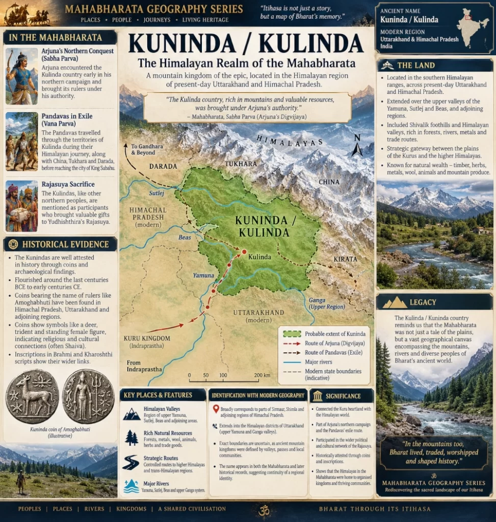
The Indira Gandhi National Centre for the Arts notes that archaeological and numismatic evidence places the Kunindas in the Shivalik foothills between the Yamuna and Sutlej, as well as in territory between the upper Beas and Sutlej. Kuninda coins have also been recovered widely across present-day Uttarakhand.
This would place the heart of Kulinda geography across parts of modern Sirmaur, Shimla and adjoining regions of Himachal Pradesh, together with the Himalayan districts of Uttarakhand connected to the Yamuna and Ganga valleys.
Some early scholars interpreted the name more broadly, suggesting that Kulinda groups may once have occupied several separate territories along the southern Himalayan slopes. This interpretation is particularly interesting because the Mahabharata itself sometimes refers not merely to one Kulinda kingdom but to the “countries” or provinces of Kulinda.
Kulinda in Arjuna’s Northern Conquest
One of the clearest references to the Kulindas occurs in the Sabha Parva during Arjuna’s Digvijaya, the great campaign undertaken before Yudhishthira’s Rajasuya sacrifice.
Arjuna was assigned the northern direction. As he marched northwards from the Pandava realm, the Kulinda country was among the first territories he encountered.
The Sabha Parva states that Arjuna brought the rulers of the Kulinda country under his authority before proceeding towards other northern territories. Significantly, the passage indicates that he accomplished this without resorting to unusually severe measures, suggesting submission or limited resistance rather than a prolonged war.
The location makes geographical sense. From Indraprastha, a northern army moving towards the Himalayan foothills through the upper Yamuna region would naturally approach territories associated with the Kulindas before advancing deeper into the mountain world.
The episode therefore provides one of the strongest clues for placing the Kulinda country directly north of the Kuru-Pandava political sphere.
The Pandavas Journey Through Kulinda
The Kulinda region appears again during the Pandavas’ years of exile, when they travelled deep into the Himalayas.
The Vana Parva describes the Pandavas moving through a remarkable sequence of mountain lands before returning from the Himalayan interior. The text specifically speaks of their crossing the territories of Kulinda, describing them as lands rich in valuable resources.
One passage records the Pandavas passing through the countries associated with China, Tukhara, Darada and Kulinda, after which they crossed difficult Himalayan terrain and reached the city of King Subahu.
The reference is important because it portrays Kulinda not as an isolated town or small settlement but as a recognisable Himalayan territorial region through which major mountain routes passed.
The landscape envisioned by the epic is one of steep valleys, forests, river crossings and difficult mountain tracks connecting the Gangetic plains with the higher Himalayas.
King Subahu and the Himalayan Kingdom
The Mahabharata tradition also associates the Pandavas’ Himalayan journeys with King Subahu, a ruler connected in several later interpretations with the Kulinda or neighbouring Kirata country.
The Pandavas were received hospitably in his realm during their travels through the mountains. Some regional historical traditions therefore identify Subahu as a Kulinda ruler, although the different recensions and translations of the epic do not always describe his political affiliation in precisely the same way.
What is clearer is that Subahu’s kingdom belonged to the same broader Himalayan geographical world through which the Pandavas travelled after passing through the lands of Kulinda.
The episode illustrates something important about the political geography of the epic. The Himalayas were not portrayed merely as an empty wilderness occupied by sages and supernatural beings. They contained organised kingdoms, tribal territories, mountain communities and trade routes, each controlled by its own rulers.
Kulinda and the Rajasuya
The Kulindas appear again in connection with Yudhishthira’s Rajasuya sacrifice.
Northern Himalayan peoples brought exotic products to the ceremony, including items characteristic of the mountains such as precious metals, animal products and other valuable goods. Scholarly studies of the relevant Sabha Parva passages include the Kulindas among the northern communities participating in this wider political and ceremonial network.
Their presence demonstrates that the Kulinda region was integrated into the political geography surrounding the Kuru kingdom despite the formidable Himalayan terrain separating the mountain valleys from the plains.
The relationship between the Pandavas and these northern peoples appears to have involved both military submission during Arjuna’s campaign and later participation in Yudhishthira’s imperial ceremony.
From the Kulindas of the Epic to the Historical Kunindas
The most fascinating aspect of Kulinda geography is that a similarly named people emerges clearly in the historical record several centuries later.
The Kunindas became an identifiable political power in the western Himalayas during roughly the final centuries BCE and opening centuries CE. Their coins have been discovered across Himachal Pradesh, Uttarakhand and neighbouring areas.
It would be too strong to claim that the historical Kuninda kingdom represented exactly the same political state described in the Mahabharata. The epic reached its surviving form over a long period, while the securely dated Kuninda coinage belongs to a much later historical age.
Nevertheless, the continuity of the name Kulinda–Kuninda, combined with the remarkably similar Himalayan geographical setting, suggests that the literary tradition preserved knowledge of a long-established population or regional identity in this part of the Himalayas.
Amoghabhuti and the Coins of the Kunindas
The best-known historical Kuninda ruler is Amoghabhuti, whose name appears on large numbers of silver coins.
Many of these coins contain inscriptions identifying the issuer with the Kunindas. They commonly display a deer together with a standing female figure, while other symbols reflect the religious traditions circulating across northern India.
The coins are particularly valuable because some carry legends in Brahmi and Kharoshthi scripts, reflecting the Kuninda kingdom’s connections with different cultural and commercial zones of northwestern India.
Later Kuninda issues also display strongly Shaiva imagery, including representations associated with Shiva and the trident.
The existence of an extensive coinage demonstrates that this was no insignificant hill community. By the historical period, the Kunindas possessed an organised political and economic system capable of issuing currency and participating in long-distance commerce.
Himalayan Trade and Natural Wealth
The geography of Kuninda helps explain its importance.
The western Himalayas contain several natural corridors connecting the plains with the high mountain valleys and ultimately the trans-Himalayan world. Communities controlling these corridors could benefit from the movement of salt, wool, metals, forest products, livestock and other commodities.
Archaeological research on the central Himalayas suggests that the Kunindas exploited the resources of the mountain region while participating in both internal and external trade.
This economic background also helps explain why the Mahabharata describes the Kulinda territories as being rich in valuable materials.
Mountain kingdoms could control products difficult to obtain in the plains as well as the passes through which trade moved. Their apparent remoteness did not prevent them from becoming part of much larger commercial and political networks.
Rivers and Mountains Shaped Kulinda Identity
The Kulindas belonged fundamentally to the world of the rivers descending from the Himalayas.
The Yamuna, Sutlej and Beas, together with the upper Ganga system further east, formed natural corridors between valleys and settlements. River valleys offered cultivable land while ridges and passes controlled movement between different Himalayan regions.
Ancient geographers also remembered the Kuninda country in connection with the great rivers rising in the Himalayan mountains. The classical geographer Ptolemy referred to a region usually rendered as Kulindrine, which scholars have associated with the Kunindas and the Himalayan headwaters region.
The political geography of Kulinda was therefore probably quite different from the large territorial kingdoms of the Gangetic plains. Authority may have depended heavily upon controlling individual valleys, routes and clusters of hill communities.
Kulinda and the Modern Landscape
In modern geographical terms, the Kulinda world can be placed broadly across the western and central Himalayan belt of Uttarakhand and Himachal Pradesh.
Parts of the ancient territory probably included the upper Yamuna region, the Shivalik foothills and Himalayan valleys extending westwards towards the Sutlej and Beas systems. Areas around present-day Dehradun, Uttarkashi and adjoining Garhwal regions, together with parts of Sirmaur, Shimla and neighbouring Himachal districts, fall within the broad geographical zone associated by historians with the Kulindas.
The exact boundaries cannot be reconstructed as modern political borders. Ancient Himalayan states were often defined by river valleys, mountain passes and the allegiance of local communities rather than by sharply surveyed frontiers.
Kuninda in the Geography of the Mahabharata
The importance of Kuninda in the Mahabharata lies in the way it connects the familiar political world of the Kurus with the far more complex geography of the Himalayas.
For Arjuna marching north from Indraprastha, the Kulinda country represented one of the gateways into the Himalayan world. For the Pandavas during exile, its valleys formed part of the route through which they travelled between sacred mountain regions and inhabited kingdoms.
Centuries later, historical Kuninda rulers issued their own coins across much the same region.
That unusual combination of epic references, geographical consistency and numismatic evidence makes Kuninda one of the most compelling locations in the Mahabharata geography series.
The ancient Kulinda or Kuninda country can therefore be identified broadly with the Himalayan region of present-day Uttarakhand and Himachal Pradesh, especially the territories associated with the upper Yamuna, Sutlej, Beas and adjoining Ganga valleys. In the world of the Mahabharata, it stood at the threshold between the kingdoms of the northern plains and the vast mountain country beyond—a land of warriors, river valleys, forest wealth and strategic routes through the Himalayas.
You may also like
-
Durga versus Mahishasura: Weapons, Battlefield Tactics and the Triumph of Shakti
-
Kuluta: The Kullu Valley Kingdom of the Mahabharata
-
Trigarta: The Kangra–Jalandhar Kingdom of the Mahabharata
-
Kasmira: The Kashmir Valley and the Northwestern Himalayan World of the Mahabharata
-
Nepala: The Kathmandu Valley and the Central Himalayan World of the Mahabharata
