
The ancient Arbuda of the Mahabharata can be identified with Mount Abu and the adjoining highlands of present-day southern Rajasthan, close to the modern border with Gujarat. Unlike kingdoms such as Chedi, Matsya or Saurashtra, Arbuda appears in the epic primarily as a sacred mountain and pilgrimage landscape rather than as a clearly described political kingdom. The Vana Parva directly names Arbuda during its great enumeration of tirthas and associates the mountain with the celebrated hermitage of the sage Vasishtha. Scholarly studies of the Mahabharata’s sacred geography have consequently identified Arbuda with modern Mount Abu with considerable confidence.
The identification is strengthened by the remarkable survival of the ancient name. Mount Abu was known historically as Arbuda or Arbudachala, while inscriptions from the medieval period refer to the surrounding territory as Arbuda-mandala, Arbuda-bhumi and Arbuda-bhu-mandala. The modern name Abu is generally understood as a shortened form of the older Arbuda.
Arbuda therefore represents one of the clearest examples in Mahabharata geography where an ancient sacred landscape can still be located within a recognisable modern setting. The mountain rises dramatically from the plains of southern Rajasthan, with Gujarat lying immediately to the south-west, while the wider Aravalli system connects it with the interior of Rajasthan.
Arbuda at a Glance
Arbuda was the ancient name associated with Mount Abu, the great mountain massif of southern Rajasthan. In the Mahabharata, it appears primarily as a sacred tirtha connected with Vasishtha’s hermitage. The epic describes Arbuda as a mountain associated with Himavat and refers to a remarkable fissure or cavity in the earth at the site.
Its approximate modern identification is Mount Abu and the surrounding Sirohi region of Rajasthan, extending conceptually into the adjoining Aravalli foothills near the Gujarat border. No Mahabharata-period ruler or capital of an Arbuda kingdom can be securely identified from the epic. Later inscriptions, many centuries after the epic tradition, use Arbuda as the name of a political territory whose rulers were based at Chandravati, near modern Abu Road.
The safest geographical identification is therefore Arbuda → Mount Abu and adjoining southern Rajasthan → India.
Where Was Ancient Arbuda?
Ancient Arbuda is identified with the Mount Abu massif in modern Sirohi district of Rajasthan. Mount Abu forms part of the southern Aravalli system close to the Rajasthan-Gujarat boundary. The mountain rises sharply above the surrounding plains and contains Rajasthan’s highest summit, Guru Shikhar, which reaches approximately 1,722 metres above sea level.
The geographical setting is distinctive. Much of western Rajasthan is associated with dry or semi-arid landscapes, yet Mount Abu contains forested slopes, rocky valleys, seasonal streams and comparatively cool uplands. This contrast would have made the mountain stand out dramatically to ancient travellers approaching from the plains.
Modern Abu Road lies at the foot of the mountain, while Sirohi lies to the east. The Gujarat border is only a short distance to the south-west, and the Aravalli ranges continue into northern Gujarat. This position placed Arbuda between the landscapes of Rajasthan, Gujarat and the routes leading toward Malwa and western India.
Arbuda Is Directly Named in the Mahabharata
The strongest evidence for Arbuda comes from the Vana Parva, during the extensive description of sacred places that the Pandavas could visit while living in exile.
The Mahabharata directs Yudhishthira toward Arbuda, describing it as associated with Himavat and referring to a place where a fissure or cavity had once existed in the earth. The passage then mentions the famous hermitage of Vasishtha at the mountain. Academic discussions of the Arbuda tradition have identified this passage as one of the earliest textual references establishing Mount Abu as a sacred landscape.
This is important because the identification does not depend solely on later Puranic tradition. Arbuda already belongs to the Mahabharata’s tirtha geography.
The mountain was therefore known to the epic not simply as a distant geographical feature but as a spiritually important place associated with sages, austerity and pilgrimage.
Arbuda in the Tirtha-Yatra of the Vana Parva
The pilgrimage passages of the Vana Parva create an extraordinary sacred map of Bharatavarsha. Rivers, mountains, forests, hermitages and coastal tirthas are arranged into journeys through which a pilgrim could accumulate merit and encounter places associated with gods and sages.
Arbuda appears within this sacred network.
One reconstruction of the Mahabharata’s western pilgrimage sequence places Pushkara, the Narmada, the Chambal region, Arbuda, Prabhasa, the western coast and Dvaravati within a broad geographical progression. This sequence helps place Mount Abu between the inland sacred landscape of Rajasthan and the western coastal world of Gujarat.
Arbuda therefore acts almost as a geographical bridge. To its north and east lay the Rajasthan interior, while routes south and west eventually reached Gujarat, Saurashtra and the Arabian Sea.
Vasishtha’s Hermitage at Arbuda
The Mahabharata’s most important association with Arbuda is sage Vasishtha.
The Vana Parva describes his celebrated hermitage as located at the mountain. Later religious traditions dramatically expanded this association, eventually making Vasishtha one of the central figures in the sacred mythology of Mount Abu.
Vasishtha is one of the most important sages in the wider Sanskrit tradition. In the Mahabharata, he appears repeatedly in genealogical narratives and teachings concerning kings, sages and the power of ascetic discipline. His association with Arbuda therefore gave the mountain considerable religious prestige.
Later traditions locate the Vasishtha Ashram near Gaumukh on Mount Abu, where a spring emerges from a rock formation. The present religious landscape developed long after the composition of the Mahabharata, so individual modern structures should not automatically be treated as surviving epic-period monuments. Nevertheless, the continuity of the Vasishtha tradition at Mount Abu is striking.
The Mysterious Fissure at Arbuda
One unusual detail in the Mahabharata’s description is the reference to a chhidra or opening in the earth at Arbuda.
Historical studies of Mount Abu have noted this feature and connected it with later legends explaining the origin of the mountain. Some older scholars speculated that the tradition might preserve a distant memory of geological activity or unusual formations in the region, although such interpretations remain speculative.
The important textual point is simpler. The Mahabharata knew Arbuda not only as a mountain but as a landscape with a distinctive physical feature memorable enough to enter sacred geography.
Later traditions transformed this fissure into an elaborate story involving Vasishtha’s sacred cow and the formation of the mountain itself.
The Later Story of Nandini and the Mountain
The elaborate story most commonly associated with the origin of Mount Abu belongs principally to later Puranic and regional tradition, rather than to the brief Mahabharata reference.
According to this tradition, Vasishtha’s cow Nandini fell into a deep chasm. Sarasvati filled the cavity with water, allowing the cow to escape. Vasishtha then sought the help of Himalaya, who sent the mountain Nandivardhana to fill the chasm. A serpent named Arbuda carried the mountain to the site, and the grateful sage gave the mountain the name Arbuda.
This story appears in later traditions surrounding the Arbuda Mahatmya and should therefore be distinguished from the shorter Mahabharata account. The epic already knows Arbuda, Vasishtha and the remarkable fissure, but the fully developed origin narrative belongs to a later layer of sacred literature.
That distinction is valuable because it allows the Mahabharata evidence to stand on its own while still explaining how the sacred geography developed over subsequent centuries.
Was Arbuda a Kingdom in the Mahabharata?
Arbuda is often included on maps of ancient India alongside kingdoms such as Matsya, Malava and Saurashtra. However, the Mahabharata evidence requires a distinction between Arbuda the sacred mountain region and a clearly defined political kingdom.
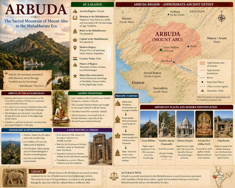
The epic securely identifies the mountain and pilgrimage site, but it does not provide a well-developed royal narrative for an Arbuda kingdom. There is no securely identified Mahabharata-era ruler comparable to Virata of Matsya, Shishupala of Chedi or Akriti of Saurashtra.
It is therefore more accurate to describe Arbuda in this series as an ancient geographical and sacred region centred on Mount Abu.
The name later acquired a much clearer political meaning. Medieval inscriptions refer to the surrounding territory as Arbuda-mandala, and Paramara rulers governed the region from Chandravati. Those developments provide valuable evidence for the long survival of the geographical name but should not be projected backward into the Mahabharata period.
No Secure Mahabharata Ruler of Arbuda
Because Arbuda does not receive the same dynastic treatment as many kingdoms in the epic, no individual can confidently be listed as its Mahabharata ruler.
This is not evidence that the Mount Abu region lacked rulers or organised communities. It simply reflects the type of information preserved by the epic. Arbuda enters the narrative because of its sacred importance rather than because one of its kings plays a decisive role in the Pandava-Kaurava struggle.
A publication-ready geographical profile should therefore state clearly that the Mahabharata ruler of Arbuda is not securely identified.
Later kings known as the Paramaras of Arbuda belong to approximately the tenth to thirteenth centuries CE, enormously later than the epic setting. Their history should be discussed as part of Arbuda’s later legacy rather than presented as Mahabharata history.
No Secure Epic Capital
The same caution applies to the capital.
The Mahabharata does not name a capital city of Arbuda. The sacred mountain itself is the focus of the epic passage.
Much later, the Paramara dynasty ruling the Arbuda region established its political centre at Chandravati, an ancient settlement near the foot of Mount Abu and close to present-day Abu Road. The Corpus Inscriptionum Indicarum notes that the medieval Paramara house ruling around Abu used territorial expressions such as Arbuda-mandala and had its capital at Chandravati.
Chandravati is therefore an important historical site for understanding the later political region of Arbuda, but it should not be labelled the capital of Mahabharata-era Arbuda.
The most accurate entry is “Epic-period capital: not identified; Chandravati became the capital of the later Arbuda Paramaras.”
Arbuda and the Aravalli Mountains
Arbuda belongs to the Aravalli mountain system, one of the defining geographical features of Rajasthan.
The Aravallis stretch across western and central Rajasthan before continuing toward Gujarat. Mount Abu forms the great southern highland of the system, rising far above many surrounding peaks. Rajasthan Tourism identifies Guru Shikhar at Mount Abu as the highest point in the Aravalli range at roughly 1,722 metres.
This physical geography helps explain Arbuda’s role as a sacred retreat. Mountains throughout the Mahabharata frequently serve as places of austerity because they combine physical isolation with forests, caves, streams and commanding landscapes.
Arbuda fits that pattern exceptionally well. Its elevation and comparatively green environment distinguish it from the surrounding plains, creating precisely the kind of secluded landscape associated with ancient hermitages.
Arbuda as a Forested Sanctuary
Modern Mount Abu remains ecologically unusual within Rajasthan. The Mount Abu Wildlife Sanctuary contains rugged cliffs, valleys and forests, while elevation ranges from the foothills to Guru Shikhar. Official environmental assessments describe vegetation ranging from subtropical thorn forest at lower elevations to comparatively lush vegetation in valleys and watercourses higher on the mountain.
The precise vegetation of the Mahabharata period cannot be reconstructed simply from modern conditions. Nevertheless, the mountain’s ability to support relatively rich vegetation and water sources helps make the ancient tradition of hermitages entirely understandable.
Arbuda was therefore not merely a bare rocky summit. It was a mountain landscape capable of supporting religious settlements, wildlife and long-term human habitation.
Guru Shikhar: The Highest Point
The most prominent physical landmark of modern Mount Abu is Guru Shikhar, the highest point in Rajasthan and the entire Aravalli system.
The peak rises to approximately 1,722 metres and today contains a shrine associated with Dattatreya. Rajasthan Tourism describes the summit as offering extensive views across the surrounding Aravalli landscape.
Guru Shikhar itself should not automatically be equated with a specifically named peak in the Mahabharata. Its value for the geographical reconstruction lies in showing the physical scale of Arbuda.
From such heights, ancient travellers would have looked across the plains linking Rajasthan with northern Gujarat. The mountain’s commanding presence explains why it became a landmark not only in geography but also in religious imagination.
Arbuda and the Gujarat Frontier
Mount Abu stands very close to the modern Rajasthan-Gujarat boundary. Abu Road lies on the western Banas River, with the Gujarat border only a short distance away. Government environmental studies note that the surrounding Aravalli system continues southward toward Gujarat.
This location makes Arbuda important for understanding the relationship between several ancient regions. Saurashtra and Anarta lay farther west and south-west within Gujarat, while Malava occupied territory toward the east. Rajasthan’s western and central regions extended northward from the mountain.
Arbuda therefore belonged to a cultural crossroads rather than an isolated corner of Rajasthan.
Travellers moving between Gujarat and the Rajasthan interior could pass close to the Mount Abu region, while routes farther east connected with Malwa and central India.
Arbuda and Anarta
The ancient region of Anarta is generally associated with northern and western Gujarat and appears separately within the Mahabharata’s geographical world.
Arbuda lay close to the north-eastern approaches to this region. The Aravalli foothills descend toward the plains of northern Gujarat, making Mount Abu one of the most prominent natural landmarks on routes between Rajasthan and the Gujarat interior.
The two should therefore be shown as neighbouring but distinct geographical identities. Arbuda is centred on the mountain massif and adjoining southern Rajasthan, whereas Anarta belongs principally to the Gujarat plains farther south and west.
No rigid border can be reconstructed from the Mahabharata, and any map should display their relationship as approximate.
Arbuda and Malava
Toward the east and south-east lay the broader world of Malava and Avanti.
The Mount Abu highlands stood on the western edge of routes that could eventually lead across southern Rajasthan toward Malwa. Later political history repeatedly demonstrates interaction between the rulers of the Arbuda region and the Paramaras of Malwa, although those events belong to the medieval period.
Geographically, the relationship is useful for orienting Arbuda on the Mahabharata map. Mount Abu lies considerably west of Ujjain and the core Malwa plateau, while occupying the mountainous corridor between Gujarat and the Rajasthan interior.
Showing Malava to the east of Arbuda therefore helps readers understand the region’s position within western Bharat.
Arbuda and the Western Pilgrimage Route
One of the most interesting aspects of the Mahabharata reference is Arbuda’s position within the broader pilgrimage geography of western India.
The Vana Parva’s tirtha sequence connects sacred places across Rajasthan and Gujarat. Studies of the text note a geographical progression that includes Pushkara, Arbuda, Prabhasa, the Sarasvati’s western reaches and Dvaravati.
This does not necessarily represent a precise ancient road itinerary, since the pilgrimage lists contain multiple textual layers. Yet the geographical logic is striking.
A pilgrim moving west and south from Rajasthan could visit Arbuda before continuing toward the sacred coastal world of Saurashtra and Dvaraka.
Arbuda thus belongs to both Rajasthan’s mountain geography and Gujarat’s wider western sacred network.
Pushkara and Arbuda
Pushkara, near modern Ajmer, forms another major sacred landscape of Rajasthan in the Mahabharata.
Although the two places are separated by considerable distance, both appear within the epic’s extensive tirtha geography. Pushkara represents a sacred lake landscape in central Rajasthan, while Arbuda represents a mountain sanctuary farther south.
Together they demonstrate that Rajasthan’s role in the Mahabharata extends well beyond kingdoms and battlefields. The epic remembers the region as a landscape filled with sacred water bodies, mountains and hermitages.
For a geographical map, Pushkara can be shown to the north-east of Arbuda as another important point of reference, although it should not be presented as part of the Arbuda territory itself.
The Sacred Geography Expanded in the Puranas
The religious importance of Arbuda continued to grow after the Mahabharata.
The Skanda Purana contains an extensive Arbuda section that magnifies the sacred landscape of the mountain. Academic study of this material describes the Arbuda-khanda as a detailed tirtha-mahatmya devoted to Mount Arbuda and notes that the place was already known as a tirtha in the Mahabharata.
Later traditions associated Arbuda with numerous deities, sages, caves, springs and sacred peaks. Shaiva traditions became especially important, while Jain patronage eventually transformed Mount Abu into one of India’s great architectural and pilgrimage centres.
The expansion of the sacred landscape should therefore be understood chronologically. The Mahabharata establishes Arbuda as an important mountain tirtha associated with Vasishtha; later texts greatly enrich its mythology.
Arbuda Devi and the Survival of the Ancient Name
One modern religious site preserves the ancient name particularly clearly: Arbuda Devi, also known as Adhar Devi.
The Rajasthan Devasthan Department identifies the shrine on Mount Abu with the goddess Arbuda and records later Puranic traditions connecting the deity with Arbudachala.
The present shrine and its developed mythology are later than the Mahabharata, but the survival of the name demonstrates how deeply Arbuda became embedded in the religious identity of Mount Abu.
Ancient place-names often disappear completely as languages and political systems change. Arbuda is unusual because its memory survives not only in scholarship but within living religious tradition.
Vasishtha and the Later Agnikula Tradition
Mount Abu later became closely associated with the famous Agnikula tradition, according to which certain Rajput dynasties emerged from a sacrificial fire performed by Vasishtha.
Medieval inscriptions and literary traditions connected the Paramaras particularly strongly with this story. Epigraphic evidence from Mount Abu describes Vasishtha and traditions in which a warrior is produced through sacrificial power.
This material is historically important but should not be confused with the Mahabharata passage. The Mahabharata establishes Vasishtha’s hermitage at Arbuda; it does not provide the developed medieval Agnikula genealogy later associated with Rajput clans.
The later tradition nevertheless demonstrates how the epic association with Vasishtha became the foundation for powerful political origin myths.
The Paramaras of Arbuda
By the early medieval period, Arbuda had become the name of a clearly defined political territory.
A branch of the Paramara dynasty ruled the region around Mount Abu from roughly the tenth century onward. Their inscriptions use expressions such as Arbuda-mandala, Arbuda-bhumi and Arbuda-bhu-mandala-pati, showing that the ancient sacred name had developed into a territorial designation.
Their capital was Chandravati, situated near the foothills of Mount Abu. The dynasty interacted with the Chaulukyas of Gujarat, the Paramaras of Malwa and neighbouring Rajasthan powers.
This later history is valuable because it demonstrates continuity. A mountain named Arbuda in the Mahabharata eventually gave its name to an entire political district.
However, the medieval Paramaras should never be inserted directly into the epic narrative. More than a millennium of historical development separates the two contexts.
Chandravati at the Foot of Arbuda
The ruins of Chandravati near modern Abu Road preserve the memory of the later political importance of the Arbuda region.
Medieval inscriptions establish Chandravati as the capital of the Paramara branch ruling around Mount Abu.
For a modern reader, Chandravati is therefore useful as a historical marker showing where political power later concentrated around the sacred mountain. It also demonstrates how control of the approaches to Mount Abu became strategically important.
On an infographic, Chandravati can be labelled carefully as “Later historical capital of the Arbuda Paramaras — not a Mahabharata-period capital.”
That distinction preserves both the archaeological importance of the site and the accuracy of the epic reconstruction.
The Dilwara Temples Belong to a Much Later Age
Modern Mount Abu is perhaps most famous for the magnificent Dilwara Jain temples.
These marble temples were constructed principally between the eleventh and thirteenth centuries CE and represent some of the finest achievements of medieval Indian stone carving. Rajasthan Tourism identifies them as major Jain monuments of Mount Abu.
They should not be included as evidence for the Mahabharata period, but they are important to Arbuda’s long religious history. Their construction shows that the mountain remained a prestigious sacred landscape thousands of years after the epic tradition had identified it with Vasishtha.
Arbuda consequently became a shared religious landscape shaped by Hindu, Jain and regional traditions over many centuries.
Arbuda as Mountain Rather Than Modern District
When placing Arbuda on a modern map, it is important not to colour a very large section of Rajasthan as though the Mahabharata described a precisely bounded state.
The strongest evidence centres on Mount Abu itself.
The highlighted zone should therefore focus on the Mount Abu massif, the Abu Road-Sirohi surroundings and adjoining Aravalli foothills. A somewhat wider shaded region can represent the approximate Arbuda landscape, but its boundaries should remain explicitly uncertain.
Later Arbuda-mandala inscriptions justify showing a broader surrounding territory for historical context, yet these medieval boundaries should not be presented as if they describe the epic age.
Ancient Arbuda and Modern Geography
The modern geographical heart of Arbuda is Mount Abu in Sirohi district, Rajasthan. Abu Road provides the main foothill reference, while Sirohi lies farther east. Guru Shikhar marks the highest summit, and the mountain lies only a short distance from the Gujarat border.
The West Banas River flows through the plains around Abu Road, while the surrounding Aravalli ranges continue into northern Gujarat.
For readers familiar with modern geography, nearby regional reference points include Palanpur and Ambaji in Gujarat, Sirohi in Rajasthan and the broader routes toward Udaipur and Marwar.
These modern places should be used only for orientation, not as claimed cities of a Mahabharata Arbuda kingdom.
Arbuda’s Geographical Position in Ancient Bharat
Arbuda occupied a strategically interesting position within western India. The mountain stood near the transition between the Rajasthan highlands and the plains of Gujarat.
To the south and south-west lay the regions later associated with northern Gujarat and Anarta. Farther west lay Kachchha and Saurashtra. Malava and Avanti lay toward the east, while the Rajasthan interior connected Arbuda with Matsya and other northern regions.
This location allowed the mountain to sit within several overlapping networks: pilgrimage routes, pastoral corridors, political frontiers and routes between Gujarat and Rajasthan.
The Mahabharata remembers Arbuda primarily through religion, but its geographical importance would have extended beyond pilgrimage.
A Mountain Visible Across the Plains
The physical prominence of Mount Abu should not be underestimated.
Guru Shikhar rises more than 1,700 metres above sea level, making the massif an extraordinary landmark in western India.
For travellers moving across the plains below, the mountain would have been visible from considerable distances. Its forested uplands and springs would also have offered a dramatic environmental contrast with the hotter surrounding country.
Such landscapes naturally attract religious traditions. Mountains appear repeatedly in Indian sacred geography as places where the human world approaches the divine, where sages undertake austerities and where ordinary political authority becomes less important.
Arbuda’s terrain therefore fits its Mahabharata role perfectly.
From Epic Tirtha to Sacred Mountain of Many Traditions
The long history of Mount Abu demonstrates how sacred geography evolves.
The Mahabharata remembers Arbuda as a mountain tirtha associated with Vasishtha. Later Puranic traditions expanded the mythology of the chasm, Nandini, Nandivardhana and the serpent Arbuda. Medieval rulers then turned Vasishtha’s association with the mountain into dynastic origin traditions.
Shaiva shrines developed across the landscape, while Jain patrons constructed the spectacular Dilwara temples. Arbuda Devi, Guru Shikhar, Gaumukh and other sacred places continue to attract pilgrims today.
The details changed across centuries, but the mountain itself remained sacred.
Why Arbuda Is Important to Mahabharata Geography
Arbuda demonstrates that Mahabharata geography cannot be understood solely through political kingdoms.
Some places enter the epic because of kings and wars. Others matter because of rivers, mountains, pilgrimage routes and the presence of sages.
Arbuda belongs firmly to the second category.
The Mahabharata’s direct reference to the mountain and to Vasishtha’s hermitage provides stronger evidence for its geographical identification than exists for many more famous but disputed epic locations. Academic scholarship consequently treats Arbuda-Mount Abu as a relatively secure identification.
This makes Arbuda especially valuable in reconstructing the sacred geography of western Bharat.
The Legacy of Arbuda
The ancient name has survived across an extraordinary span of Indian history.
In the Mahabharata, Arbuda is a sacred mountain associated with Vasishtha. In later Puranic traditions, it becomes the centre of elaborate legends explaining the mountain’s creation. Medieval inscriptions transform Arbuda into the name of an administrative and political territory ruled by the Paramaras from Chandravati. Religious communities then covered the mountain with shrines, temples and pilgrimage centres.
Today the ancient Arbuda is recognised as Mount Abu, one of Rajasthan’s most distinctive landscapes.
Its highest summit, Guru Shikhar, still dominates the southern Aravallis. Forested valleys descend toward Abu Road and the plains leading into Gujarat. Sacred traditions associated with Vasishtha, Arbuda Devi and other figures remain alive, while medieval temples preserve later chapters in the mountain’s religious history.
The geographical identification can therefore be stated with considerable confidence: Arbuda in the Mahabharata corresponds to Mount Abu and its adjoining southern Rajasthan landscape in present-day India.
What should remain uncertain is the political reconstruction. The Mahabharata does not provide a securely identified Arbuda king, capital or fixed kingdom boundary. Those features belong much more clearly to later historical periods.
Seen through the epic itself, Arbuda was above all a sacred mountain of western Bharat — a place of pilgrimage, austerity and the celebrated hermitage of Vasishtha rising above the plains between Rajasthan and Gujarat.
You may also like
-
Pragjyotisha — Bhagadatta’s Kingdom of the Brahmaputra Valley
-
Samatata — The Low-Lying Deltaic Realm of Southeastern Bengal
-
Tamralipta — The Maritime Gateway of the Lower Ganga
-
Suhma — The River-and-Forest Country of Southwestern Bengal
-
Gauda — The Western Bengal Country of the Bhagirathi and the Rise of Karnasuvarna
