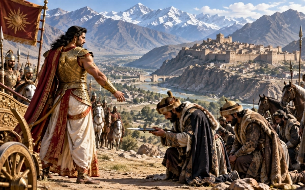
Among the historic regions of the northwestern world, Kapisa or Kapiśa occupied an exceptionally strategic position immediately north of the Kabul basin and south of the Hindu Kush. Its heartland lay around the fertile Panjshir–Ghorband river plain, with the ancient city traditionally identified with Begram, roughly 80 kilometres north of Kabul. In modern geographical terms, the ancient region falls mainly within Parwan and adjoining Kapisa areas of Afghanistan, rather than corresponding exactly with the boundaries of today’s Kapisa Province.
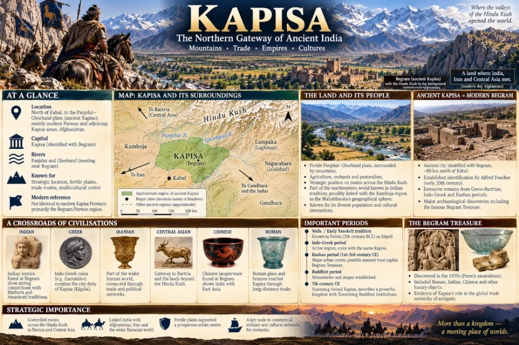
Kapisa stood at a natural junction between several important ancient regions. Kabul lay to the south, Gandhara and the Indus approaches to the southeast, Lampaka and Nagarahara towards the east, while routes across the Hindu Kush led northwards into Bactria and Central Asia. This position transformed Kapisa into much more than a mountain kingdom. For centuries it served as a commercial and political gateway linking the Indian subcontinent with Afghanistan, Iran and the lands beyond the Hindu Kush.
The Land of Kapisa
The geography of Kapisa was shaped by the Panjshir and Ghorband rivers, which descend from the Hindu Kush before meeting in the broad plain north of Kabul. The ancient urban centre associated with Kapisa overlooked their confluence. Encyclopaedia Iranica places ancient Kāpiśa at Begram, approximately 80.5 kilometres north of Kabul, overlooking the Panjshir Valley where the Panjshir and Ghorband rivers meet.
The surrounding landscape combined fertile irrigated plains with steep mountain valleys. The Kabul-Panjshir basin itself forms a highland depression enclosed by formidable ranges. Its northern section includes the Parwan-Kapisa plain, watered by the Panjshir and Ghorband rivers, while the Hindu Kush rises sharply farther north.
This geography gave Kapisa two important advantages. The well-watered plains supported agriculture and substantial settlements, while the surrounding valleys provided access to mountain passes leading towards Bactria.
Kapisa therefore stood at the point where fertile plains met strategic mountain corridors.
Ancient Kapisa and Modern Begram
The ancient city of Kapisa is conventionally identified with the archaeological site of Begram, situated near the meeting of the Panjshir and Ghorband rivers.
The ruins were known during the nineteenth century, but French archaeologist Alfred Foucher formally identified Begram with ancient Kapisa in the early twentieth century. Subsequent excavations uncovered extensive occupation remains and large numbers of coins dating from the Greco-Bactrian through Kushan periods.
The identification has become widely accepted in historical geography, although some modern archaeological scholarship has questioned whether every reference to ancient Kapisa should necessarily be equated precisely with the excavated Begram settlement. The broader placement of the Kapisa region in the Panjshir-Ghorband plain north of Kabul, however, remains secure.
An important geographical distinction is necessary here. Modern Kapisa Province is not identical with ancient Kapisa. Begram itself lies in present-day Parwan Province, close to the modern boundary with Kapisa Province. The ancient geographical name covered a broader political region whose limits changed considerably over time.
Kapisa Was Known to Ancient Indian Scholars
Kapisa was already recognised in ancient Sanskrit geographical tradition.
The fifth-century BCE grammarian Pāṇini referred to Kāpiśī, understood as the city of the Kapisa country. The Getty Research Institute’s geographical database identifies Begram with ancient Kapisa and records Pāṇini among the earliest sources referring to the city.
This is important because it demonstrates that Kapisa was known within the intellectual geography of ancient India centuries before its later prominence under Indo-Greek and Kushan rulers.
Pāṇinian tradition also preserves references to products associated with Kapisa, showing that the region was recognised not merely as a distant name but as an economically distinctive country.
Kapisa and the Geography of the Mahabharata
Kapisa requires somewhat greater caution than neighbouring regions such as Gandhara, Kamboja, Darada or Lampaka when discussing the Mahabharata.
The surviving epic does not present Kapisa as clearly and repeatedly as a separate major kingdom under that exact name. Claims sometimes made that Mahabharata 2.48.7 explicitly names Kapisa are problematic: the Sanskrit verse itself speaks generally of mountain peoples bringing tribute and does not contain the geographical name Kapisa.
Kapisa nevertheless belongs directly to the geographical world surrounding the epic’s northwestern regions. Its location lies between areas associated with Kamboja, Gandhara, Lampaka and Bahlika, all of which figure prominently in the wider geographical traditions connected with the Mahabharata.
Some twentieth-century scholars consequently proposed a closer relationship between Kapisa and Kamboja, arguing that the Kapisa region may have formed part of, or represented a political centre within, the broader Kamboja geographical sphere. Moti Chandra was among those who explored this connection in his study of the geography and economy described in the Mahabharata.
This identification remains a scholarly interpretation rather than something that should be treated as an explicit statement of the epic itself.
The safest conclusion is therefore that Kapisa formed part of the same northwestern geopolitical world represented in the Mahabharata, while its independent identification is much clearer in Paninian and later historical sources.
Kapisa in the Mahabharata
Kapisa belongs geographically to the northwestern world described extensively in the Mahabharata, although the surviving epic does not clearly identify a separate kingdom called Kapisa under that exact name. This distinction is important. The Mahabharata repeatedly refers to neighbouring peoples and regions such as Kamboja, Gandhara, Darada and Bahlika, whose territories surrounded the Kabul Valley and Hindu Kush approaches. Kapisa, centred north of Kabul around the Panjshir-Ghorband plain, stood directly within this wider geopolitical landscape.
The strongest possible connection is with Kamboja. In the Drona Parva, the epic recalls that Karna travelled to Rajapura and subdued the Kambojas, establishing Rajapura as an important political centre associated with them. The verse itself does not identify Rajapura with Kapisa, and Encyclopaedia Iranica cautions that the Kamboja capital cannot presently be located with certainty. Some twentieth-century scholars, however, including Moti Chandra, proposed that Kapisa and Kamboja represented closely related or overlapping geographical designations and suggested that the Kapisa region may have formed part of the wider Kamboja political sphere.
This interpretation fits the physical geography of the epic’s northwest. Kapisa lay between Gandhara to the southeast, Lampaka towards the east, Kamboja-associated country around the Hindu Kush, and Bahlika or Bactria beyond the mountains. Armies and travellers moving between these territories naturally passed through the Kabul-Kapisa corridor. Kapisa can therefore be placed confidently within the geographical world known to the Mahabharata, even though its independent political identity becomes much clearer in later Sanskrit and historical sources than it is in the epic itself.
Claims that Sabha Parva 2.48.7 explicitly names Kapisa should also be treated cautiously. The Sanskrit verse refers simply to mountain peoples bringing tribute to Yudhishthira and does not contain the name Kapisa. The most accurate conclusion is therefore that Kapisa was part of the same northwestern mountain and frontier zone represented in the Mahabharata, probably closely connected with the Kamboja world, but the epic does not provide a secure standalone Kapisa episode comparable to those of Gandhara, Kamboja or Darada.
Between Kamboja, Gandhara and Lampaka
Kapisa’s importance becomes especially clear when placed alongside its neighbouring regions.
To the southeast lay Gandhara, centred on the Peshawar Valley and Taxila. Eastwards, along the Kabul River corridor, lay Lampaka, corresponding broadly with the Laghman Valley, followed by Nagarahara around Jalalabad.
Towards the north and northwest, routes crossed the Hindu Kush into Bactria or Bahlika, the great oasis country around Balkh.
Kapisa stood between these geographical worlds.
Travellers moving from the Indian plains towards Bactria could travel through Gandhara and the Kabul region before crossing the Hindu Kush. Other routes passed through the Kapisa plain before entering mountain valleys leading northwards.
The city’s position near the Panjshir-Ghorband junction therefore gave it unusual strategic value.
A Gateway Across the Hindu Kush
The Hindu Kush was formidable, but it was never an absolute barrier.
Mountain passes linked the Kabul-Kapisa region with Bactria throughout antiquity. Control over these routes meant control over trade, military movement and communication between Central Asia and the northwestern subcontinent.
Kapisa consequently became a frontier where several cultural worlds overlapped.
Iranian political traditions could move southwards across the mountains, while Indian languages, religions and artistic influences moved in the opposite direction. Greek influence entered the region after Alexander’s conquest, and later Central Asian dynasties established themselves on both sides of the Hindu Kush.
Kapisa’s history reflects this continuous interaction.
The Indo-Greek Presence
The historical importance of Kapisa becomes especially visible during the Indo-Greek period.
Coins recovered from Begram demonstrate substantial Greco-Bactrian and Indo-Greek activity. One particularly important coin type associated with Eucratides contains a Kharoshthi inscription referring to the city deity of Kāpiśa, providing direct evidence for the continued importance of the regional name.
The area belonged to the political world created when Greek kingdoms established themselves across Bactria and the northwestern subcontinent following Alexander’s campaigns.
Kapisa thus occupied a frontier where Greek, Iranian and Indian political traditions interacted.
That multicultural character would become even more pronounced under the Kushans.
Kapisa Under the Kushans
Kapisa reached one of its most prosperous historical phases during the Kushan period, especially in the first centuries CE.
Begram became an important Kushan urban centre. Encyclopaedia Iranica records extensive construction there during this period and notes the tradition that Kapisa functioned as a summer royal centre.
The Kushan Empire itself was ideally positioned to exploit Kapisa’s geography. It extended from Central Asia and Bactria across Afghanistan and Gandhara into large parts of northern India.
Kapisa sat almost directly in the middle of this imperial network.
The Metropolitan Museum of Art describes Kushan territory as lying at the centre of trade routes connecting the Roman world, India, Central Asia and China, with Kapisa-Begram among the empire’s major urban centres.
Few archaeological discoveries illustrate this better than the celebrated treasures found at Begram.
The Begram Treasure
French excavations during the 1930s uncovered an extraordinary collection of luxury objects within sealed rooms at Begram.
The finds included Roman glassware and bronzes, objects associated with Egypt and the Mediterranean, Chinese lacquerware and elaborately carved Indian ivory furniture decorations.
Their geographical origins are remarkable.
Objects from the Mediterranean world had reached the same Afghan city as goods from China and India.
Whether the rooms represented a royal treasury, a merchant storehouse or another type of elite repository remains debated. What is beyond dispute is that Begram participated in an enormous network of long-distance exchange.
The discovery provides physical evidence for Kapisa’s position at the crossroads of Eurasia.
Indian Ivories in Afghanistan
Among the most striking finds from Begram were carved ivory and bone plaques, many of which once decorated elaborate furniture.
Their artistic treatment has close connections with Indian sculptural traditions of the early centuries CE. Encyclopaedia Iranica notes similarities between the Begram ivories and artistic traditions associated with Mathura and Amaravati, while the Metropolitan Museum also identifies the objects as Indian or strongly Indian-influenced luxury products.
These objects provide a vivid reminder that geographical distance did not prevent extensive cultural contact.
Indian craftsmen, merchants or luxury objects could move northwestwards through Gandhara and Afghanistan, just as Central Asian horses and western goods travelled towards India.
Kapisa was one of the principal meeting places within this exchange.
A Centre of Buddhist Culture
Kapisa also became an important centre of Buddhism during the early historical period.
Buddhist monasteries and stupas were established throughout the region surrounding Kapisa and Kabul. Encyclopaedia Iranica lists Buddhist sites around Kāpiśī-Begram among the important Kushan-period religious centres of Afghanistan.
This development formed part of a much larger Buddhist landscape extending from Mathura and Gandhara through Afghanistan and eventually into Central Asia.
Monks could travel through the same routes used by merchants and armies.
Kapisa’s importance was therefore not merely military or commercial. It became part of one of the principal corridors through which Buddhist traditions spread northwards towards Central Asia and China.
Xuanzang and the Kingdom of Kapisa
By the seventh century CE, Kapisa remained important enough to impress the Chinese Buddhist pilgrim Xuanzang.
Historical geographical studies based on his account show that Kapisa remained the principal centre of the northern Kabul basin during his journey. The ruler controlled a significant kingdom in the region, and Buddhist institutions continued to flourish there.
Xuanzang’s account belongs more than a millennium after the earliest Sanskrit references to Kapisa, yet the geographical name had survived.
This longevity is significant.
Political dynasties changed repeatedly, but the region north of Kabul retained a recognisable identity centred upon Kapisa.
Kapisa and the Later Kabul Kingdom
Eventually the political centre of gravity shifted southwards towards Kabul.
Encyclopaedia Iranica notes that ancient Kapisa had initially dominated the northern portion of the basin, but Kabul gradually gained greater political importance during the early medieval period. Even in the seventh century, however, Kapisa remained significant, and rulers associated with the region maintained authority over a wider territory.
This transition reflects changing strategic conditions.
Kapisa lay on an open plain vulnerable to armies descending from Central Asia. Kabul, situated within a more defensible basin and surrounded by mountains, offered advantages during periods of repeated invasion.
Yet the old Kapisa region did not disappear. Its valleys and routes remained strategically important long after the ancient city declined.
Agriculture and the Fertile Kapisa Plain
Kapisa’s wealth did not depend entirely on trade.
The Panjshir-Ghorband plain contained fertile agricultural land supplied by snow-fed rivers descending from the Hindu Kush.
The surrounding valleys supported orchards, grain cultivation and pastoral activity. Even today, the contrast between the cultivated valley floor and the dry mountain slopes remains one of the defining features of the landscape.
This agricultural base helped sustain the urban communities that developed around ancient Kapisa.
Trade made the region wealthy, but water and fertile land made permanent settlement possible.
Where India, Iran and Central Asia Met
Kapisa’s historical significance becomes clearest when its geography is viewed on a wider scale.
South and southeast lay Kabul and Gandhara, connecting the region with the Indus and northern India. North of the Hindu Kush lay Bactria and the Oxus basin. Westwards stretched routes towards Iran, while northeastward mountain corridors ultimately linked with Central Asia.
This placed Kapisa almost precisely at the intersection of several great cultural zones.
Greek coins, Iranian political traditions, Indian sculpture, Buddhist monasteries, Roman luxury goods and Chinese lacquerware all eventually appeared within the same geographical environment.
Few ancient regions demonstrate the interconnected character of Eurasian history more clearly.
Kapisa in Modern Geography
The ancient Kapisa region should not be mapped simply onto modern Kapisa Province.
The ancient city conventionally identified as Kapisa lies at Begram in present-day Parwan Province, north of Kabul and close to the modern Kapisa provincial boundary. Its political territory probably included parts of the wider Panjshir-Ghorband and northern Kabul basin and changed considerably through different historical periods.
The most useful modern identification is therefore:
Kapisa — the ancient region north of Kabul centred on the Panjshir-Ghorband plain and ancient Kapisa/Begram, principally within present-day Parwan and adjoining Kapisa areas of Afghanistan.
It should be represented on historical maps as an approximate regional zone rather than using the outline of modern Kapisa Province.
Kapisa represents one of the most important geographical bridges between the ancient Indian world and the lands beyond the Hindu Kush. Although its independent role in the surviving Mahabharata is less explicit than that of neighbouring Gandhara, Kamboja or Lampaka, the region belongs unmistakably to the same northwestern geographical network remembered in ancient Indian tradition.
Its historical record is exceptionally rich. Pāṇini knew Kāpiśī; Indo-Greek coins preserved its name; Kushan rulers transformed the region into a major political and commercial centre; Indian ivories, Roman glass and Chinese lacquer reached Begram; Buddhist institutions flourished across its valleys; and Xuanzang still encountered a powerful kingdom of Kapisa centuries later.
Ancient Kapisa can therefore be identified broadly with the fertile country north of Kabul around Begram and the Panjshir-Ghorband river system in modern Afghanistan. Situated immediately beneath the Hindu Kush, it stood at one of the great gateways through which the worlds of Bharat, Afghanistan, Iran and Central Asia met and influenced one another for centuries.
You may also like
-
Lampaka: The Mountain Kingdom of Laghman on the Kabul River Frontier
-
Navaratri and Ayurveda: The Nine Divine Medicinal Plants Associated with Navadurga
-
Bahlika: The Ancient Bactrian Realm of Balkh in the Mahabharata
-
Kamboja: The Horse-Breeding Frontier Kingdom of the Hindu Kush in the Mahabharata
-
Darada: The Upper Indus Mountain Realm of the Mahabharata
