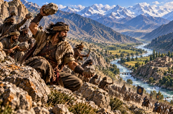
Among the northwestern mountain peoples mentioned in the Mahabharata, Lampaka occupied a strategically important region along the approaches between the Kabul Valley, Gandhara and the Hindu Kush. Ancient geographical scholarship has long identified Lampaka with the Laghman Valley of eastern Afghanistan, lying east of Kabul and northwest of Jalalabad. The country occupied the valleys associated with the Alingar and Alishang rivers, immediately north of the Kabul River, where mountain routes descending from the Hindu Kush opened towards the plains of Gandhara.
The identification of Lampaka with Laghman is one of the stronger geographical correlations among the lesser-known northwestern names preserved in Sanskrit literature. Alexander Cunningham argued that the ancient Sanskrit Lampaka survived in the later name Lamghan or Laghman, while the region also appears in Classical geographical traditions under names resembling Lambagae or Lambatae. His reconstruction placed the ancient territory on the northern side of the Kabul River, bounded broadly by the Alingar and Kunar river systems and by mountain country to the north.
The Land of Lampaka
The landscape of Lampaka was fundamentally shaped by mountains and rivers. Laghman lies where several valleys descending from the southern Hindu Kush converge before reaching the Kabul River. The Alingar and Alishang rivers carry water southwards through narrow valleys before entering the wider Kabul river system, creating strips of fertile land suitable for agriculture and settlement.
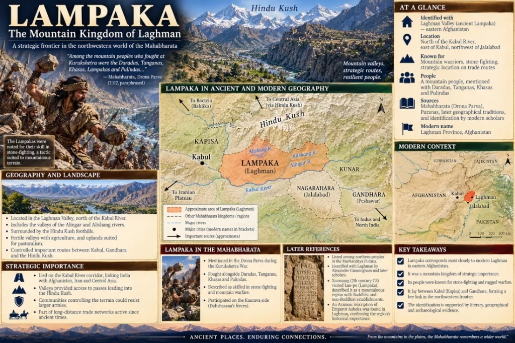
Historical descriptions identify ancient Lampaka with the district lying on the northern bank of the Kabul River above Jalalabad, including the lower Alingar and Alishang valleys. This places the region east of Kabul proper and immediately west of the Kunar-Nangarhar country.
Such geography gave Lampaka importance far beyond its size. Armies, merchants and travellers moving between Kabul and Gandhara could pass along the Kabul River corridor, while routes leading northwards through the valleys provided access towards the Hindu Kush highlands.
Lampaka was therefore a frontier kingdom situated where mountain routes met one of the principal east-west corridors of ancient northwestern South Asia.
Lampaka in the Mahabharata
References to Lampaka in the Mahabharata are considerably fewer than those to major kingdoms such as Gandhara, Kamboja or Madra. Nevertheless, one battlefield passage in the Drona Parva provides an unusually vivid description of the Lampakas.
During the Kurukshetra War, Satyaki was confronted by warriors drawn from several northern and mountain peoples. Duhshasana encouraged mountain fighters who were particularly skilled at fighting with stones, believing that their unusual method of warfare could overwhelm Satyaki.
The text describes warriors hurling enormous stones and other missiles. Among those who subsequently attacked Satyaki with swords, lances and stones were the Daradas, Tanganas, Khasas, Lampakas and Pulindas. Satyaki responded with volleys of arrows, breaking the stones in mid-air and inflicting enormous losses on the attackers.
This passage is particularly valuable because it identifies the Lampakas directly as part of the mountain-warrior world of the northwest.
Warriors Skilled in Mountain Combat
The Lampakas are not described like the large chariot armies of the Gangetic plains. Instead, they appear alongside communities accustomed to fighting in rugged terrain.
Stone fighting may sound primitive when compared with chariots, bows and elephants, but in mountainous country it could be extremely effective. Warriors positioned above a narrow route could use rocks, slings and missiles against troops attempting to climb a slope or pass through a confined gorge. Large stones rolling down steep terrain could disrupt formations that would have been far more effective on open ground.
Traditional geographical commentary on the Mahabharata specifically describes the Lampakas as a mountain people resembling the Daradas and Pulindas, skilled in stone fighting and the use of slings.
The description fits the geography of Laghman remarkably well. The valleys north of the Kabul River are surrounded by steep ridges and narrow approaches where local knowledge would have provided a significant military advantage.
Lampaka at Kurukshetra
The Drona Parva episode also gives an indication of Lampaka’s political alignment during the war.
Duhshasana, fighting for the Kauravas, ordered the mountain warriors to attack Satyaki, one of the principal Pandava allies. Lampakas are subsequently listed among the peoples taking part in that assault.
It is therefore reasonable to conclude that at least one Lampaka contingent fought on the Kaurava side at Kurukshetra.
This fits a wider pattern visible throughout the epic. Many kingdoms and warrior groups from the far northwest—including Gandharas, Kambojas, Daradas and several other mountain peoples—contributed forces to Duryodhana’s coalition.
Their participation demonstrates the enormous geographical range claimed by the war narrative. The political conflict centred on Hastinapura drew warriors not only from the Ganga-Yamuna heartland but from valleys stretching deep into the northwestern mountains.
Lampaka Among the Peoples of the North
Lampaka continued to appear in geographical literature beyond the Mahabharata.
The Markandeya Purana lists the Lampakas among northern peoples, and early geographical scholarship connected this reference directly with the Laghman region. The same tradition groups the Lampakas with several lesser-known northern communities, reinforcing their identification as inhabitants of India’s northwestern mountain frontier.
A broader classification of the ancient regions of Bharat published through the Indira Gandhi National Centre for the Arts similarly associates Lampaka with the upper Kabul Valley and identifies the region with the Lamghan of later geography.
These references suggest that Lampaka was not merely a battlefield ethnonym. It represented a recognisable geographical region within the ancient understanding of the northwestern world.
Between Gandhara and Kapisa
Lampaka’s location placed it between two major ancient regions: Gandhara to the east and southeast and Kapisa towards the west and northwest.
Gandhara centred on the Peshawar Valley, Pushkalavati and Taxila. Kapisa occupied territory around the upper Kabul Valley and regions north of Kabul. Lampaka lay between these larger political centres along the corridor leading towards Jalalabad.
This transitional location explains why the region’s political affiliation could change over time.
By the seventh century CE, the Chinese pilgrim Xuanzang described the country he called Lan-po, generally identified with Lampaka-Laghman. He reached it after crossing mountain country from Kapisa and regarded it as part of the northern Indian cultural world. At that time, Lampaka was politically subordinate to the more powerful kingdom of Kapisa.
The political situation of the seventh century cannot be projected backwards onto the Mahabharata, but the geographical relationship is extremely informative. Lampaka remained a recognised region situated between Kabul and Gandhara many centuries after its appearance in Sanskrit traditions.
Xuanzang’s Lampaka
Xuanzang provides one of the most detailed surviving ancient descriptions of the region.
His account describes Lampaka as a relatively compact territory surrounded by mountains. Cunningham’s reconstruction of the pilgrim’s itinerary places Lan-po exactly within the modern Laghman country, bounded by snowy mountains to the north and darker hill ranges on other sides.
Xuanzang also encountered Buddhist establishments in the region as well as temples belonging to non-Buddhist traditions. His description shows that by the seventh century Lampaka had become part of the complex Buddhist and Hindu cultural landscape extending from Kapisa through Gandhara towards the Indus.
This later religious landscape belongs to a period long after the epic traditions were formed, but it illustrates the continuing importance of Lampaka as a distinct geographical identity.
An Ashokan Inscription From Lampaka
One of the most important pieces of archaeological evidence connecting ancient Lampaka with modern Laghman comes from an Aramaic inscription associated with Emperor Ashoka.
The inscription was found near Pul-i Darunta in Laghman, close to the Kabul River. Scholar W. B. Henning specifically identified the district as ancient Lampaka and noted the linguistic development connecting Lampaka with the later name Laghman.
The inscription belongs to the Mauryan period and therefore cannot be used as archaeological evidence for the events described in the Mahabharata. Its significance is geographical instead.
By the third century BCE, the same Laghman corridor was clearly participating in the political and administrative networks extending from the Indian subcontinent into the northwestern frontier.
The use of Aramaic also reflects the region’s position at a cultural crossroads. Aramaic had been widely used within the earlier Achaemenid imperial world, and its survival in an Ashokan inscription demonstrates how Indian and Iranian administrative traditions could overlap in eastern Afghanistan.
A Corridor Between India and the Iranian World
Lampaka stood along one of the great natural routes connecting the subcontinent with Afghanistan and regions farther west.
From Gandhara and the Peshawar Valley, travellers could move through the Jalalabad region and then follow the Kabul River westwards. Laghman provided access to valleys branching northwards, while the main corridor continued towards Kabul.
From Kabul, further routes crossed the Hindu Kush towards Bactria or continued westwards through the Afghan highlands.
Lampaka therefore lay along a chain linking Taxila, Gandhara, Nagarahara, Kabul, Kapisa and ultimately Central Asia and Iran.
The discovery of Aramaic inscriptions in Laghman provides archaeological confirmation that these connections were active during the early historical period.
Lampaka was consequently not isolated simply because it was mountainous. Its valleys formed part of the infrastructure through which distant worlds remained connected.
Mountain Valleys and Agriculture
Despite the rugged landscape, Lampaka contained fertile valleys capable of supporting settled communities.
Snow and rainfall in the surrounding mountains fed the Alingar, Alishang and other streams. Irrigation could transform river terraces into productive agricultural zones, while higher slopes provided pasture for livestock.
This combination of cultivated valley floors and pastoral uplands is characteristic of much of eastern Afghanistan.
Communities could grow cereals and fruits in the valleys while maintaining animals in the surrounding hills. Such mixed economies were particularly well suited to regions where cultivable land was limited but mountain pastures were extensive.
The same environment could produce hardy soldiers accustomed to moving over steep terrain.
The Kabul River as Lampaka’s Southern Highway
Although Lampaka itself occupied the valleys north of the river, the Kabul River was the principal geographical artery of the region.
The river rises in Afghanistan and flows eastwards through the Kabul and Jalalabad regions before entering present-day Pakistan and eventually joining the Indus near Attock.
For ancient travellers, the Kabul River valley formed one of the easiest natural approaches through the northwestern mountain barrier.
Lampaka’s position above this corridor meant that its inhabitants could influence movement between Kabul and Gandhara. A ruler controlling the valley entrances could monitor caravans, armies and travellers using the route.
This strategic geography helps explain why the region remained politically important across so many different periods.
Lampaka and Nagarahara
Immediately southeast of Lampaka lay Nagarahara, associated with the Jalalabad region.
Xuanzang’s itinerary is particularly useful here. After leaving Lampaka, he travelled southeast, crossed a major river and entered Nagarahara. Cunningham used this description to strengthen the identification of Lampaka with Laghman.
The two countries occupied neighbouring sectors of the Kabul River corridor.
Lampaka lay principally north of the river amid the mountain valleys, while Nagarahara occupied the broader basin around Jalalabad farther downstream.
Together they formed the transition from the Kabul highlands towards Gandhara.
A Frontier Between Several Cultural Worlds
Few regions illustrate the meaning of a cultural frontier better than Lampaka.
To the east lay Gandhara, strongly connected with the Indian subcontinent. To the west lay Kabul and Kapisa. Beyond the Hindu Kush stood Bactria and the Central Asian world. Iranian political and linguistic influences reached into the region from the west, while Sanskritic and Buddhist traditions moved along the same routes from the east.
Lampaka therefore cannot be understood as belonging exclusively to one isolated cultural sphere.
Its history reflects continuing interaction among Indian, Iranian, Afghan and Central Asian populations.
This geographical reality also helps explain why ancient Sanskrit sources classify Lampaka among the distant northern peoples while later Buddhist travellers still regarded it as part of the wider northern Indian cultural landscape.
The Survival of the Name
The continuity between Lampaka and Laghman is one of the strongest arguments for the identification.
Henning traced the historical development of the regional name through forms related to Lampaka, while Cunningham likewise considered modern Lamghan a descendant of the Sanskrit geographical designation.
Names often survive even when kingdoms disappear.
The political institutions governing the valley changed repeatedly—from ancient regional rulers to larger imperial systems—but the geographical identity attached to the valley endured.
That survival allows modern geography to preserve an echo of the name encountered in Sanskrit literature.
Lampaka in Modern Geography
In modern terms, ancient Lampaka corresponds most closely with Laghman Province in eastern Afghanistan, especially the lower Alingar and Alishang valleys and the country immediately north of the Kabul River.
The region lies east of Kabul and northwest of Jalalabad, with the Hindu Kush foothills rising towards the north.
Its ancient boundaries should not be assumed to coincide exactly with the limits of modern Laghman Province. Political territories changed over time, and Lampaka may at different periods have controlled adjoining valleys.
The most useful geographical identification is therefore:
Lampaka — the Laghman Valley and adjoining mountain country north of the Kabul River, east of Kabul and northwest of Jalalabad — present-day eastern Afghanistan.
The Mountain Frontier of the Mahabharata
Lampaka represents one of the lesser-known but geographically revealing regions of the Mahabharata.
The epic remembers the Lampakas as mountain warriors, fighting alongside Daradas, Khasas, Tanganas and Pulindas during the Kurukshetra War. Their distinctive method of combat involved stones and other weapons suited to the rugged terrain from which they came.
Later geographical traditions continued to place Lampaka among the peoples of the north, while historical scholarship identifies the country convincingly with modern Laghman in eastern Afghanistan. The identification is strengthened by Xuanzang’s description of Lan-po, the survival of the regional name and the discovery of an Ashokan Aramaic inscription in the Laghman district.
Lampaka therefore stood along one of the great northwestern gateways of ancient Bharat: a land of mountain warriors, narrow valleys and strategic routes, positioned between Gandhara and Kabul where the roads of the Indian subcontinent met those of Afghanistan, Iran and Central Asia.
Its modern geographical correlation can be stated simply as Lampaka — the Laghman Valley east of Kabul in present-day Afghanistan, a small but strategically significant mountain country whose name survived across centuries of northwestern history.
You may also like
-
Navaratri and Ayurveda: The Nine Divine Medicinal Plants Associated with Navadurga
-
Bahlika: The Ancient Bactrian Realm of Balkh in the Mahabharata
-
Kamboja: The Horse-Breeding Frontier Kingdom of the Hindu Kush in the Mahabharata
-
Darada: The Upper Indus Mountain Realm of the Mahabharata
-
Abhisara: The Himalayan Frontier Kingdom Between Kashmir and Punjab in the Mahabharata
