Mahabharata Geography — Suhma
Modern geographical correspondence: Southwestern West Bengal, India
Along the western edge of the Bengal delta, where the immense river-built plains of the east begin to meet the older red-soil country of Rarh, ancient Indian tradition remembered a region called Suhma. Its landscape was neither purely deltaic like much of Vanga nor deeply inland like the plateau country farther west. Rivers descending from the Chhotanagpur uplands crossed fertile plains on their journey towards the Bhagirathi-Hooghly and the Bay of Bengal, while forests, wetlands and cultivated settlements formed a transitional country between interior Bengal and the maritime coast.
In Mahabharata geography, Suhma is best associated with southwestern West Bengal, particularly the country west of the lower Bhagirathi-Hooghly and extending through parts of modern Howrah, Hooghly, southern Purba Bardhaman and adjoining Medinipur country. Its boundaries changed significantly through time, and ancient sources do not permit a precise modern district-by-district reconstruction. Historical geography nevertheless consistently places Suhma in southwestern Bengal and distinguishes it from neighbouring Vanga and, in the Mahabharata itself, from Tamralipta.
The region occupies an important place in the epic because Suhma appears not merely in a geographical catalogue but within the political history of the Kuru world. Its legendary origin is linked with Anga, Vanga, Kalinga and Pundra; King Pandu campaigns against it; Bhima encounters Suhma during his eastern conquest before Yudhishthira’s Rajasuya; a powerful Suhma ruler appears among the kings attending that sacrifice; and the Karna Parva remembers Suhma among the countries that Karna had previously subdued.
Suhma in the Ancient Geography of Bengal
Ancient Bengal was not remembered as a single country called Bengal. Sanskrit, Prakrit and later historical traditions preserve several regional names, among them Vanga, Pundra, Suhma, Tamralipta, Radha and Samatata. These names sometimes expanded, contracted or overlapped, but their coexistence reveals a geographically diverse eastern world.
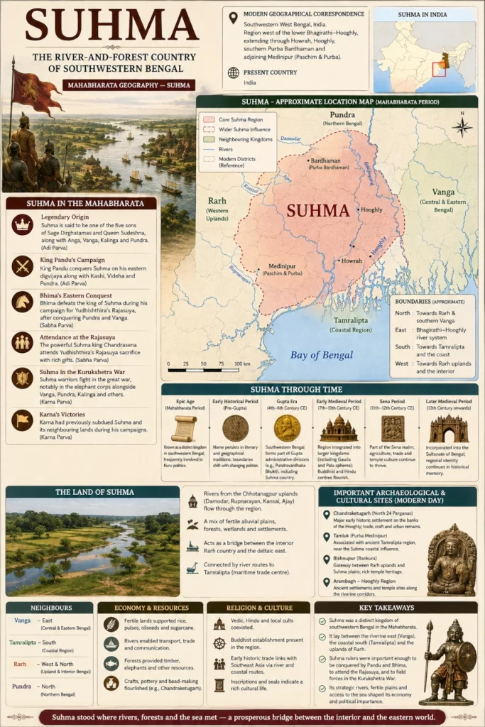
Suhma belonged primarily to the southwestern side of this mosaic. Banglapedia identifies it as an ancient territorial unit of southwest Bengal and notes that the Mahabharata distinguishes the Suhmas from both the Vangas and the people of Tamralipta. Later literary evidence places Suhma broadly between the Bhagirathi and the Kansai region, extending southward towards the sea.
This position gave Suhma a distinctive character. To the east lay the increasingly water-dominated plains associated with Vanga. To the southeast lay the maritime world of Tamralipta. To the west and northwest stretched the older uplands and forest zones of Rarh, eventually rising towards the Chhotanagpur plateau. Suhma consequently stood between riverine Bengal, forested interior routes and the eastern sea.
The Legendary Birth of Suhma
The Adi Parva preserves one of the most important genealogical traditions for the ancient east. In the account of the sage Dirghatamas and Queen Sudeshna, five sons are named Anga, Vanga, Kalinga, Pundra and Suhma, and the text explains that five countries subsequently came to bear their names.
The story is epic genealogy rather than a historical record of state formation, but geographically it is highly revealing. The five names correspond to some of eastern India’s most persistent ancient regional identities. Anga belonged farther west near the lower Ganga, Pundra to northern Bengal, Vanga to the central and eastern delta, Kalinga to the Odisha-Andhra coast and Suhma to southwestern Bengal.
By presenting them as brothers, the epic expresses both relationship and distinction. These countries belonged to the same broad eastern political world, yet each possessed its own identity. Suhma was therefore not simply another name for Vanga, nor was Vanga the name for all of ancient Bengal.
King Pandu’s Campaign Against Suhma
Suhma appears directly in the political history of the Kuru dynasty even before the birth of the Pandavas. After marrying Kunti and Madri, King Pandu undertakes a great campaign of conquest intended to strengthen Kuru authority. The Adi Parva describes him defeating Magadha, Videha and other eastern regions before leading his forces against Kashi, Sumbha/Suhma and Pundra.
The translation preserves the form “Sumbha,” while historical discussions of the passage generally identify the country with Suhma. The sequence is geographically plausible because Pandu is moving eastwards through the lower Gangetic political world.
This reference is significant because it shows that Suhma was already imagined as a country important enough to attract Kuru military attention. Pandu’s campaign was not a raid into an unknown frontier. It moved through established kingdoms whose submission enhanced the prestige of Hastinapura.
The episode also establishes a long connection between the Kurus and eastern India. Decades before Bhima marched into Bengal for Yudhishthira’s Rajasuya, his own father had already been remembered as campaigning in the Suhma country.
Bhima’s Eastern Digvijaya
Suhma reappears prominently when Bhima undertakes the eastern Digvijaya before Yudhishthira’s Rajasuya. The Sabha Parva provides one of the richest geographical journeys in the epic, tracing Bhima through numerous kingdoms of the Gangetic east and Bengal.
During the campaign, Bhima defeats Suhmas and Prasuhmas, then continues through Magadha, Pundra and Vanga. Farther in the same account he defeats Samudrasena and Chandrasena, Tamralipta, Karvata and again a ruler of the Suhmas before proceeding towards kings of the seacoast and eventually the Lohitya country.
The repetition may preserve different Suhma groups, frontier territories or textual traditions, but the geographical implication is important. Suhma existed within the densely populated political landscape of eastern India and was closely connected with Vanga, Pundra and Tamralipta while remaining distinct from them.
Bhima’s campaign is particularly valuable because it makes it difficult to identify Suhma simply with Tamluk. The epic names Tamralipta and Suhma separately in the same sequence. Later texts could incorporate Tamralipta into Suhma, but the Mahabharata-era geographical tradition appears to preserve separate identities.
Suhma and Prasuhma
The Sabha Parva also names the Prasuhmas alongside the Suhmas. The exact geographical identity of Prasuhma remains uncertain, and it would be unwise to create a precise territory for it on a modern map.
The name may indicate an adjoining or related Suhma population, perhaps occupying a neighbouring tract of southwestern Bengal. Ancient Indian geographical catalogues frequently preserve related tribal or regional names whose exact political boundaries cannot now be recovered.
What the passage does demonstrate is that Suhma was not necessarily a tiny isolated kingdom centred on one town. The name may have belonged to a wider ethnogeographical zone containing several related communities or political units.
The Suhma King at Yudhishthira’s Rajasuya
After the Pandava campaigns had secured tribute and political recognition across Bharata, rulers from distant lands assembled at Yudhishthira’s Rajasuya sacrifice. The Sanskrit text of the Sabha Parva explicitly includes a powerful Suhma ruler among the kings arriving for the ceremony, alongside rulers from many other regions of India.
This transforms Suhma from a territory conquered by the Pandavas into an active participant in their imperial political world. A ruler from southwestern Bengal travelled to Indraprastha and took his place among kings drawn from the north, northwest, east and south.
The journey from Suhma to Indraprastha would have followed the great communication systems connecting Bengal with the middle and upper Gangetic plain. River valleys, ferries and overland routes linked what might appear on a modern map to be extremely distant regions.
Suhma therefore stood within a network of royal diplomacy that stretched across much of the subcontinent.
Karna and the Suhmas
The Suhmas later appear in the Karna Parva when Dhritarashtra laments the death of Karna and recalls the extraordinary range of peoples the warrior had previously subdued for Duryodhana. Among those named are the Videhas, Suhmas, Angas, Pundras, Kalingas, Vatsas and several other peoples. Karna is said to have forced them to pay tribute for Duryodhana’s aggrandisement.
This reference reveals the unstable political environment of the epic. A kingdom might submit to one imperial claimant during one campaign and later be compelled by another powerful ruler to acknowledge a different overlord.
Suhma thus became connected with both sides of the wider Kuru political rivalry. Bhima subdued the region in preparation for Yudhishthira’s Rajasuya, while Karna later conquered it as part of his own campaigns undertaken for Duryodhana.
The eastern kingdoms were therefore not passive spectators to the struggle centred upon Hastinapura. They formed part of the broader competition for supremacy that preceded Kurukshetra.
A Country West of Vanga
The relationship between Suhma and Vanga is fundamental to locating the region. Both were ancient components of Bengal, but the literary evidence consistently distinguishes them.
Historical geography places Vanga principally farther east within the great delta, whereas Suhma occupied the country west of the principal Bhagirathi channels, approaching the Rarh uplands. A modern scholarly reconstruction places Suhma along the southern stretch west of the Ganga-Bhagirathi, including much of the country corresponding to southern Bardhaman, Hooghly and Howrah.
This created a natural geographical transition. Travelling east from Suhma, the landscape became increasingly dominated by the river channels and wetlands of the Bengal delta. Travelling west, the ground gradually became older, higher and less continuously alluvial.
Suhma consequently stood at the point where deltaic Bengal met the Rarh country.
Suhma and Tamralipta
The relationship between Suhma and Tamralipta is more complicated because it changed through time.
In Bhima’s eastern campaign, the Mahabharata distinguishes the ruler of Tamralipta from the ruler of Suhma. This indicates that the epic tradition recognised Tamralipta as a separate political or territorial entity at that stage.
Later literature sometimes treats Tamralipta as part of Suhma. Banglapedia notes that the Dashakumaracharita no longer treats them as separate communities and instead places Tamralipta within Suhma.
The apparent contradiction is easily explained by changing political geography. A major port could function as an independent principality during one period and later be incorporated into a larger neighbouring kingdom.
For Mahabharata geography, therefore, Tamralipta should remain distinct from Suhma, while the two should be understood as closely connected neighbours within southwestern Bengal.
Tamralipta and the Road to the Sea
Although the epic treats Tamralipta separately, its proximity profoundly influenced Suhma. Modern Tamluk stands near the lower Rupnarayan system in Purba Medinipur and preserves the geographical memory of one of ancient eastern India’s most celebrated maritime centres.
Suhma consequently lay close to routes leading towards the Bay of Bengal. Agricultural products, forest materials and goods arriving from the interior could travel through river valleys towards coastal markets, while commodities arriving through maritime networks could move inland.
This helped give southwestern Bengal a dual orientation. It belonged politically and culturally to the great eastern river world, but it also possessed access to the sea through neighbouring coastal centres.
The Bhagirathi-Hooghly — Suhma’s Eastern Waterway
The Bhagirathi-Hooghly system formed one of the most important geographical reference lines in ancient southwestern Bengal. Historical reconstructions frequently place Suhma on the western side of this river system, with Vanga lying farther east.
The river was not merely a boundary. It was also a route connecting inland Bengal with the sea. Settlements along its banks could communicate northwards towards the Gangetic interior and southwards towards coastal markets.
For inhabitants of Suhma, the Bhagirathi therefore marked both a geographical edge and an economic opportunity. Ferries linked communities across the water, while river traffic moved goods between regional centres.
The ancient political boundary could shift, but the river continued to structure the movement of people and resources.
The Damodar Country
Farther west, the Damodar crossed the Rarh landscape before entering the lower Bengal plains. Before modern dams and embankments transformed its behaviour, the river was famous for destructive flooding and frequently altered the countryside through which it flowed.
Such rivers were simultaneously dangerous and beneficial. Floodwaters could devastate settlements, yet the sediment they deposited renewed agricultural soils. Communities learned to establish villages upon higher ground and to adapt cultivation to seasonal variations in water.
The southern Bardhaman-Hooghly zone, often included within reconstructions of Suhma, therefore possessed a geography shaped by the constant interaction between older upland terrain and flood-fed river valleys.
The Rupnarayan and Kansai
Towards the south and southwest, the Rupnarayan and Kansai or Kangsabati systems formed another important geographical zone. Later literary geography associated Suhma with the country extending towards the Kansai, while Banglapedia notes the tradition placing Suhma between the Bhagirathi and Kansai and stretching towards the sea.
These rivers linked the interior with the lower coastal country around Tamluk and Medinipur. Their valleys provided corridors through terrain that became progressively more wooded and upland towards the west.
The resulting landscape differed significantly from central and eastern Vanga. It was still profoundly influenced by rivers, but the country contained more pronounced transitions between floodplain, red-soil upland, woodland and coastal lowland.
Suhma and the Ancient Rarh Country
One of the strongest later identifications connects Suhma with southern Rarh, or Dakshina Radha. Historical scholarship notes that Suhma was eventually absorbed into the broader regional identity of Rarh and that the medieval commentator Nilakantha regarded Suhma and Radha as equivalent.
Rarh broadly refers to the western Bengal country lying beyond the most intensely deltaic tracts. Its terrain includes alluvial river valleys but also extensive areas of lateritic soil, woodland and gently undulating land approaching the Chhotanagpur plateau.
The association helps explain Suhma’s geographical character. It was not simply another watery delta kingdom. Its western side belonged to a landscape increasingly influenced by the older geological formations of eastern India.
Suhma therefore formed an important transition between the Bengal delta and the plateau hinterland.
Forests and the Western Hinterland
The western approaches to Suhma would have contained much more extensive forest than is visible across heavily settled modern West Bengal. Sal and other woodland communities once covered large parts of the Rarh and adjoining plateau country.
These forests supplied timber, honey, wax, medicinal plants and animals, while also creating routes controlled by local communities whose political relationship with larger kingdoms could vary greatly.
For a Suhma ruler, the forest hinterland represented both wealth and difficulty. Agricultural authority could be strongest in river valleys and densely settled plains, while control became less direct as roads entered wooded and broken country.
Ancient political maps should therefore be imagined as networks of settlements and communication corridors, not as uniformly governed coloured blocks.
Agriculture Between Floodplain and Red Soil
Suhma’s geography allowed several forms of agriculture to coexist. In the eastern and southern river valleys, alluvial soils supported wet cultivation, especially where monsoon water and river channels could be managed effectively. Farther west, cultivation adapted to less fertile red and lateritic soils.
Rice would naturally become one of the dominant crops across much of the wetter Bengal landscape, while pulses, oilseeds and other crops could supplement agriculture in areas less continuously supplied with water.
The contrast between fertile river bottoms and drier uplands would have shaped settlement density. Villages clustered around dependable water, while woodland remained more extensive across less productive terrain.
This geographical diversity may help explain why Suhma retained a regional identity separate from the more thoroughly deltaic Vanga country.
The Monsoon Over Suhma
Monsoon rain transformed the landscape every year. Rivers swelled, low-lying fields filled with water and roads became difficult to traverse. Mud, floodwaters and unstable river crossings could make military movement considerably more challenging than across the dry plains of northwestern India.
Bhima’s conquest of the eastern kingdoms therefore represented more than a sequence of battlefield victories. Moving an army through Bengal required knowledge of river crossings, seasonal conditions and local routes.
During the drier months the countryside presented another appearance. Water withdrew from floodplains, fields became accessible and long-distance movement became easier.
The rhythm of political and economic life was consequently tied closely to the rhythm of the rains.
A Land Connected to the Ganga and the Sea
Suhma’s location gave it access to two very different worlds. Through the Bhagirathi and neighbouring river routes, the region connected northwards with the wider Ganga system and ultimately the political heartlands of northern India. Through Tamralipta and the lower rivers, it opened towards the Bay of Bengal.
This position would have encouraged movement of goods, pilgrims, messengers and armies. Traders from inland regions could descend towards coastal markets, while goods arriving by sea could travel through southwestern Bengal towards the interior.
Suhma was therefore neither an isolated forest country nor simply a coastal kingdom. Its strength came from occupying the meeting ground between river, hinterland and sea.
Suhma and the Eastern Political World
The Mahabharata repeatedly associates Suhma with other countries of the east. Its legendary genealogy links it to Anga, Vanga, Pundra and Kalinga. Pandu’s campaigns connect it with Kashi and Pundra. Bhima’s Digvijaya places it within the sequence of Magadha, Pundra, Vanga and Tamralipta, while Karna’s conquests again associate it with Anga, Pundra and Kalinga.
These recurring combinations demonstrate that the epic possessed a reasonably sophisticated geographical conception of eastern India. The names are not randomly scattered. They represent distinct countries linked through a common network of rivers and routes.
Suhma’s place within that network was southwestern Bengal, where the eastern plains approached both the Rarh hinterland and the maritime coast.
Suhma Beyond the Mahabharata
Later Sanskrit literature preserves the geographical name even after the political world represented in the Mahabharata had disappeared. Kalidasa’s Raghuvamsha describes Raghu’s eastern conquest and places the Suhmas west of Vanga and near the Bengal coastal world. Historical geographers have used this passage to support the identification of Suhma between the Bhagirathi and Kansai regions.
Patanjali also mentions Suhma alongside Vanga and Pundra, demonstrating that these regional names remained recognisable within early historical India’s geographical vocabulary.
The persistence of the name across different literary traditions suggests that Suhma was not merely an invention of one epic episode. It belonged to an enduring geographical memory of southwestern Bengal.
From Suhma to Dakshina Radha
Over time, however, the name Suhma gradually disappeared from common geographical usage. The broader term Radha or Rarh became increasingly important, and southern Rarh eventually absorbed much of the territory earlier associated with Suhma.
Historical work on Bengal notes that Rarh was divided into northern and southern components and that Suhma became closely associated with the southern division.
This development followed a pattern seen repeatedly across ancient Indian geography. A regional name might flourish for centuries, then gradually be replaced as political dynasties, languages and administrative systems changed.
The landscape remained, but the vocabulary used to describe it evolved.
Finding Suhma in Modern West Bengal
The ancient Suhma landscape can still be visualised across southwestern West Bengal. Beginning west of the lower Bhagirathi-Hooghly, the country extends through portions of Howrah and Hooghly towards the Damodar basin. Farther west and northwest lie the southern Bardhaman tracts, while southwards the landscape approaches the Rupnarayan and the Medinipur country.
The exact inclusion of Tamluk and Tamralipta should remain cautious because the Mahabharata distinguishes Tamralipta from Suhma. Later literature could include it within Suhma, demonstrating that the southern boundary changed over time.
The clearest geographical core is therefore the southwestern Bengal country west of the Bhagirathi, north and northwest of ancient Tamralipta, and east of the deeper Rarh-plateau interior.
Modern cities and intensive agriculture have transformed the region, but its rivers still reveal the older structure of the land.
The Suhma Landscape in the Epic Age
An ancient traveller approaching Suhma from the east would first leave behind the densely channelled country of Vanga and cross one of the great waterways leading towards the Bhagirathi system. Beyond the river, the land would gradually change. Wide alluvial plains continued, but stretches of woodland became more frequent and the terrain slowly rose towards the west.
Villages stood close to rivers, ponds and cultivable land. Boats carried people along the lower waterways, while carts followed tracks leading towards inland markets. During the monsoon, swollen rivers interrupted journeys and fields disappeared beneath water. In the dry season, movement became easier and merchants travelled between river settlements and coastal centres.
Farther south lay the approaches towards Tamralipta and the Bay of Bengal. Farther west stood the forests and red-earth country of Rarh. Northward, roads ultimately connected with the larger Gangetic system.
Within this transitional landscape stood the chiefs and rulers remembered by the Mahabharata as the Suhmas.
When Bhima Reached Suhma
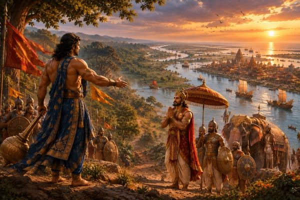
Bhima’s eastern Digvijaya gives this vanished country one of its most vivid epic moments. The powerful Pandava advances through kingdom after kingdom as Yudhishthira prepares to claim imperial dignity through the Rajasuya. Eventually his forces enter the Suhma world.
The arrival of a large army would have transformed the countryside. Dust rose from drier roads while elephants, horses, chariots and infantry moved towards river crossings. Local rulers gathered troops or negotiated submission. Boats and ferries would have become strategically important as the army entered increasingly river-dominated Bengal.
Bhima defeats the Suhmas and Prasuhmas and eventually continues towards the greater eastern kingdoms. Later in the same expedition another ruler of Suhma submits as Bhima moves through Vanga, Tamralipta and the seacoast.
The episode places southwestern Bengal firmly within the imperial geography of the Pandavas.
Suhma Between Yudhishthira and Duryodhana
The political history preserved by the epic did not end with Bhima’s victory. A Suhma ruler subsequently appears among the kings associated with Yudhishthira’s Rajasuya, demonstrating the region’s integration into the Pandava political system.
Karna later subdues the Suhmas as part of his campaigns undertaken for Duryodhana.
Together, the episodes reveal a kingdom caught within the rivalry of two Kuru power centres. The ruler of Suhma was geographically distant from Hastinapura, but the political ambitions of the Kuru princes reached all the way into southwestern Bengal.
This is one of the recurring lessons of the Mahabharata’s geographical passages. Kurukshetra was a northern battlefield, but the political processes that produced the war involved countries across the entire subcontinent.
Suhma — The Southwestern Country of Ancient Bengal
Suhma occupies an important place in Mahabharata geography because it preserves the memory of southwestern Bengal as a distinct region before Bengal acquired a single overarching political identity. The Adi Parva links Suhma genealogically with Anga, Vanga, Kalinga and Pundra. King Pandu campaigns against the country, Bhima subdues its rulers during his eastern Digvijaya, a powerful Suhma king appears at Yudhishthira’s Rajasuya, and Karna later remembers Suhma among the lands brought under Duryodhana’s authority.
Geographically, Suhma belonged broadly to southwestern West Bengal, particularly the country west of the Bhagirathi-Hooghly and extending towards the Damodar, Rupnarayan and Kansai river systems. Historical scholarship associates its later territory strongly with southern Rarh, while the Mahabharata indicates that neighbouring Tamralipta retained a separate identity during the epic geographical tradition.
Its landscape was one of transitions. Fertile alluvial fields lay beside older red-soil country. River routes led east towards the Bengal delta and north towards the Ganga, while forest roads reached west into the Rarh hinterland. To the south, the waterways opened towards Tamralipta and the Bay of Bengal.
Suhma was therefore neither purely inland nor entirely maritime. It occupied the western threshold of the Bengal delta, controlling a landscape where river plains met forest country and where routes from the Indian interior approached the eastern sea.
The name eventually faded and much of its territory came to be remembered as southern Rarh, but the Mahabharata preserves an older geography. Before Bengal became a single familiar cultural region, Suhma stood as one of its ancient countries—a land of rivers, forests and fertile plains on the southwestern edge of the eastern world.
You may also like
-
Gauda — The Western Bengal Country of the Bhagirathi and the Rise of Karnasuvarna
-
Pundra — The Northern Bengal Kingdom of the Karatoya and the Ancient City of Pundranagara
-
Vanga — The River Kingdom of the Bengal Delta and the Eastern Sea
-
Kishkindha — The Boulder Kingdom of Pampa, Rishyamukha and the Tungabhadra
-
Setu — The Sacred Southern Crossing Between Rameswaram and Lanka
