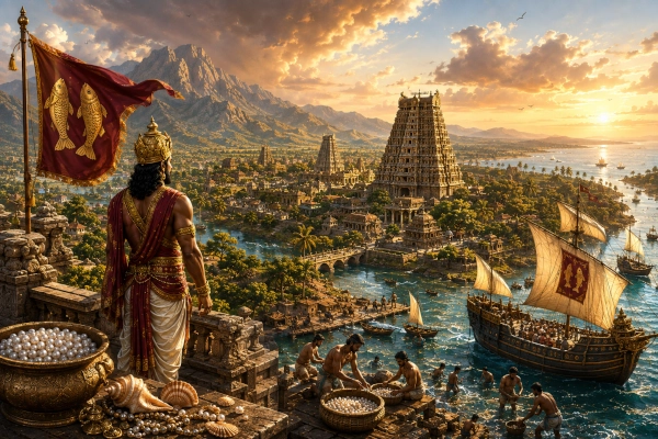
Mahabharata Geography — Pandya
Modern geographical correspondence: Southern Tamil Nadu, particularly the Madurai and Tirunelveli regions, India
At the far southern end of Bharata lay a country of remarkable geographical contrasts. Mountain chains rose along its western horizon, broad valleys opened around rivers flowing eastward, dry scrublands alternated with intensely cultivated fields, and beyond the eastern plains stretched a coast whose shallow waters became famous for pearls and conch shells. This was the ancient country of the Pandyas, one of the major southern peoples recognised by the Mahabharata and one of the oldest political names to survive in the historical traditions of Tamil Nadu.
For the purposes of Mahabharata geography, Pandya can be located broadly in southern Tamil Nadu, with its strongest historical heartland around Madurai and the Vaigai basin, extending southward through the Tirunelveli country and the Tamiraparani valley towards the Gulf of Mannar. Its precise boundaries varied enormously through time, and it would be misleading to draw the epic Pandya country according to the frontiers of any later dynasty. Nevertheless, the convergence of epic references, early Tamil traditions, archaeology and subsequent historical geography leaves little doubt that the Pandya name belonged to India’s deep south.
The Mahabharata gives Pandya a particularly interesting position. Unlike some southern regions that appear mainly in geographical catalogues, Pandya enters the political and military narrative of the epic. Pandya rulers bring tribute to Yudhishthira, Pandya forces join the Pandavas before the Kurukshetra War, and a formidable Pandya king eventually fights one of the epic’s most dramatic duels against Ashvatthama. The epic therefore remembers the Pandyas not as inhabitants of a distant and vaguely understood southern frontier, but as an established kingdom participating directly in the affairs of Bharata.
Pandya in the Geography of Southern Bharata
The geographical world represented in the Mahabharata extends far beyond the Kuru and Panchala heartlands of northern India. Its catalogues recognise numerous peoples of the peninsula, including Cholas, Keralas, Mushikas, Vanavashikas, Kuntalas and others. Although manuscript traditions and translations differ in the ordering and spelling of southern names, the wider epic repeatedly recognises Pandya as a distinct southern political identity, separate from neighbouring Chola, Kerala and other regions.
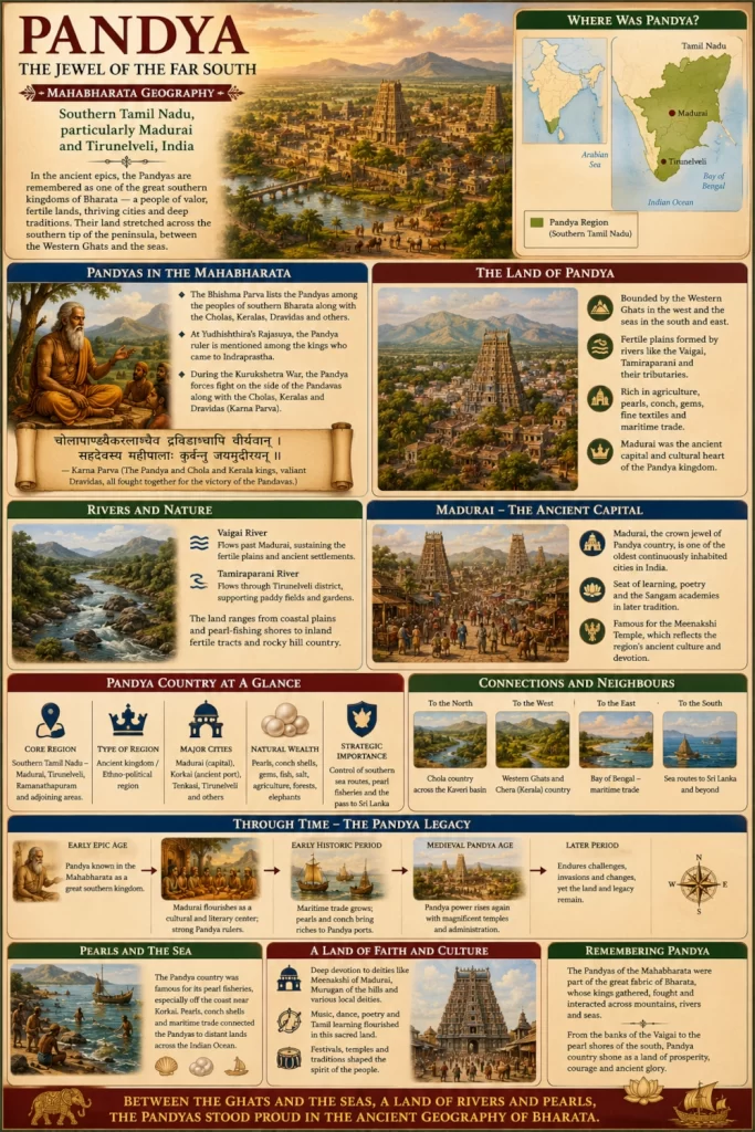
This distinction is important. Later histories of Tamilakam are often summarised around the three great crowned dynasties—the Cheras, Cholas and Pandyas—but the geographical foundations of those identities were different. The Chola heartland lay principally around the Kaveri basin farther north. The Chera or Kerala sphere faced the western coast beyond the Ghats. The Pandya country occupied the deep south, centred upon the Vaigai region and extending towards the Tamiraparani plains and the seas around the southern peninsula.
Pandya therefore stood at one of the great geographical crossroads of peninsular India. To the north lay the Chola country and the routes towards central Tamil Nadu. To the west rose the southern Western Ghats and passes leading into Kerala. To the east lay the Bay of Bengal and the Gulf of Mannar, while the sea routes towards Lanka opened to the southeast. This combination of inland valleys, mountain resources and maritime access would become one of the defining strengths of Pandya country.
The Pandya King at Yudhishthira’s Rajasuya
One of the most vivid Pandya references occurs during the description of the extraordinary tribute brought to Yudhishthira’s Rajasuya sacrifice at Indraprastha. The Sabha Parva remembers the kings of Chola and Pandya arriving with rich products from the far south. They brought golden vessels containing fragrant sandal preparations from the southern mountains, quantities of sandalwood and aloe wood, brilliant gems and finely worked cloth.
The description is extraordinarily valuable for geography because the gifts are not arbitrary objects. They evoke the ecology and trade of southern India. Sandalwood points towards the forested mountain country of the south, while gems, fine textiles and aromatic products suggest established systems of production and exchange. The accompanying references to southern hills such as Malaya connect Pandya and Chola with the mountainous spine of peninsular India.
Imagine the arrival of such a delegation at Indraprastha. After travelling north through several kingdoms, Pandya representatives entered a capital crowded with rulers from almost every region of the subcontinent. Their gifts carried the scent and material wealth of the far south into the Kuru court. Sandalwood that had grown in southern hills, textiles produced hundreds of kilometres away and precious objects from a maritime kingdom became visible symbols of Yudhishthira’s claimed sovereignty over a geographically enormous Bharata.
The episode also demonstrates how deeply connected ancient geographical imagination considered the subcontinent to be. Madurai’s distant southern world was not beyond the political horizon of Hastinapura and Indraprastha. Roads, royal embassies, merchant networks and political campaigns connected them.
Sahadeva’s Southern Campaign and Pandya
Before Yudhishthira could perform the Rajasuya, his brothers undertook campaigns in different directions to secure recognition and tribute. Sahadeva was assigned the south. Traditions of the Sabha Parva describe him moving through numerous kingdoms and eventually reaching the territories of southern India, where Pandya appears among the countries brought within the Rajasuya network. Some southern recensions preserve additional material concerning the Pandya country, although textual variations mean that particular genealogical details should be handled cautiously.
The geographical significance of Sahadeva’s expedition is nevertheless clear. The epic imagines the road to the far south passing through a sequence of identifiable political regions rather than through an empty wilderness. The Pandya country stood near the southern culmination of this long journey.
For a northern army travelling towards Pandya, the landscape would have changed repeatedly. The broad northern plains would eventually give way to the Deccan plateau, then to river valleys and hill systems farther south. Entering Tamil country brought increasingly different climatic and ecological conditions, before the route finally reached the hot plains, rocky hill country and coastal environments of the Pandya south.
Pandya Joins the Pandavas
When attempts at peace failed and the great alliances for Kurukshetra began forming, the Pandya king chose the Pandava side. The Udyoga Parva describes the forces gathering around Yudhishthira and records that the Pandya ruler arrived with his own substantial contingent. He joined allies such as Satyaki, Dhrishtaketu of Chedi, Jayatsena of Magadha, Drupada and Virata, whose combined armies formed the Pandava coalition.
The participation of Pandya dramatically expands the geographical scale of the Kurukshetra War. Warriors from the extreme south of the peninsula were imagined standing alongside Panchalas from the central Gangetic world, Chedis from central India, Yadavas from the west and other peoples drawn from across Bharata.
For the Pandya army, reaching Kurukshetra would itself have been an extraordinary undertaking. Troops, horses, elephants, weapons, provisions and camp followers had to move northwards across enormous distances. River crossings and political territories had to be negotiated, food obtained and animals maintained throughout the journey.
When Pandya warriors finally arrived on the northern plain, they were fighting in an environment far removed from their homeland. The rivers and dry seasonal landscape of Kurukshetra bore little resemblance to the Vaigai valley, the southern Ghats or the coastal plains around the Gulf of Mannar.
Yet the epic remembers them there.
Malayadhvaja Pandya — A Southern Warrior at Kurukshetra
The most dramatic Pandya episode appears in the Karna Parva. Dhritarashtra asks Sanjaya specifically about the Pandya king whose prowess has already attracted attention. Sanjaya responds with an extraordinary description of a ruler who possessed immense confidence in his own martial ability and considered himself capable of standing among the foremost warriors of the age.
In this section the king is identified as Malayadhvaja Pandya. Other epic passages and textual traditions contain the related name Sarangadhvaja, producing some uncertainty about whether the names refer to the same Pandya ruler or preserve different traditions. Rather than forcing the material into an artificial certainty, the safest conclusion is that the epic strongly remembers a celebrated Pandya king fighting for the Pandavas, while the exact form of his name varies across passages and traditions.
The description of Malayadhvaja is unusually impressive. He charges into the Kaurava formation and destroys chariots, cavalry, infantry and elephants with showers of arrows. His attack becomes severe enough that Ashvatthama, the son of Drona, personally moves against him. Sanjaya even depicts Ashvatthama acknowledging the Pandya king’s nobility, learning and martial skill before challenging him.
The encounter that follows is one of the most vivid southern contributions to the entire Kurukshetra narrative.
Malayadhvaja Against Ashvatthama
Malayadhvaja initially withstands Ashvatthama’s enormous shower of arrows and displays exceptional archery. He cuts down incoming shafts, attacks his opponent’s horses and damages the forces protecting Ashvatthama’s chariot. The battle becomes a contest between two highly skilled warriors rather than a brief encounter in the confusion of a larger engagement.
Eventually Ashvatthama destroys Malayadhvaja’s chariot and kills its horses and driver. The Pandya ruler does not retreat. Instead, when a riderless war elephant approaches, he leaps onto the animal and continues fighting from its back. The episode is particularly striking because the epic specifically portrays him as experienced in fighting from an elephant, suggesting the versatility expected of a major southern warrior.
From the elephant, Malayadhvaja hurls a powerful weapon that smashes Ashvatthama’s magnificent diadem. The humiliation sends Drona’s son into a fury. Ashvatthama responds with devastating accuracy, killing the elephant and finally cutting down the Pandya ruler.
The death is brutal, as many of the Mahabharata’s battlefield deaths are, but the narrative treatment is significant. Malayadhvaja does not die anonymously among thousands of soldiers. His prowess receives an entire description, his opponent praises him and his final battle is against one of the most formidable surviving Kaurava warriors.
Pandya had travelled from the far south to Kurukshetra, and the epic makes its king impossible to overlook.
The Malaya Mountain on the Pandya Standard
One of the most fascinating geographical details appears during Malayadhvaja’s battle with Ashvatthama. The Pandya king’s standard is described as bearing a device associated with the Malaya mountain, while sandal and other aromatic substances are also invoked in the imagery surrounding him.
The detail links the warrior directly with the mountainous geography of southern India. Malaya in Sanskrit geographical tradition is associated with the southern mountain systems, famous above all for fragrant woods such as sandal. The same mountain appears in the Rajasuya tribute passage when the Chola and Pandya kings bring sandal preparations from the south.
Thus the Pandya king carried part of his homeland symbolically into battle.
His banner did not merely identify an individual commander. It evoked a landscape of mountains, forests and aromatic wealth hundreds of kilometres from Kurukshetra. To soldiers watching that banner advance, it represented the distant southern kingdom from which Malayadhvaja had come.
Madurai — The Historical Heart of Pandya Country
The Mahabharata does not securely establish Madurai as the capital of the Pandya ruler in the specific passages discussed above, and it is important not to insert later history into the epic without qualification. The association between the Pandyas and Madurai becomes exceptionally strong in later literary, archaeological and historical traditions.
Madurai eventually emerged as the principal political and cultural centre of the Pandya kingdom and remained inseparable from Pandya history for centuries. The Government of Tamil Nadu’s Madurai district history records the city’s long Pandya association and its later importance as the seat from which Pandya rulers patronised Tamil literary culture.
Geographically, Madurai occupies an excellent position for a royal centre. It stands within the Vaigai basin, protected by ranges and rocky hills at a distance while remaining surrounded by agricultural country. Roads from Madurai could lead north towards the Kaveri region, west towards the Ghats and Kerala passes, south towards Tirunelveli and east towards the coastal plains.
Madurai therefore sat near the centre of the Pandya geographical world rather than at its maritime edge.
The Vaigai — River of the Pandya Capital
The Vaigai is central to understanding the landscape around Madurai. Flowing eastward across southern Tamil Nadu, it creates an agricultural corridor through a region that otherwise experiences long dry periods and considerable seasonal variation in rainfall.
For the communities living along its banks, the river meant water, cultivation, settlement and communication. Even where its seasonal flow fluctuated, irrigation systems allowed water to be directed towards surrounding fields. Over many centuries, the relationship between Madurai and the Vaigai became so close that the river entered deeply into Tamil literary and cultural memory.
Archaeology has added a new dimension to this landscape. Keeladi, situated southeast of Madurai near the Vaigai, has revealed a large Sangam-age settlement. The Tamil Nadu Department of Archaeology describes the archaeological mound as extending across more than 110 acres, demonstrating the presence of substantial organised settlement in the Vaigai region during the early historical period.
Keeladi belongs to a period much later than any straightforward dating of the events described in the Mahabharata and should not be presented as an epic Pandya city. Its importance lies elsewhere: it demonstrates how deeply rooted urban and literate culture eventually became within the very river valley traditionally associated with Pandya power.
From the Vaigai to the Tamiraparani
South of the Madurai region the Pandya landscape continues towards the Tamiraparani, one of the great rivers of southern Tamil Nadu. Rising in the Western Ghats, the river descends through the Tirunelveli country and creates a remarkably fertile valley before reaching the plains towards the Gulf of Mannar.
The Government of Tamil Nadu describes the Tirunelveli region as a landscape strongly shaped by the Western Ghats and the Tamiraparani system. The district’s historical identity is closely connected with its agricultural fields, river-fed settlements and long Pandya association, and Tirunelveli itself later functioned as an important southern centre under Pandya rule.
The contrast with the Vaigai basin is striking. While parts of the Madurai country can appear dry outside the monsoon, the Tamiraparani valley is intensely green where river water supports cultivation. Paddy fields, groves and villages occupy the lowlands beneath mountains rising dramatically towards the west.
For an ancient ruler, control of this valley meant access to one of the richest agricultural zones in the far south.
Tirunelveli — The Southern Interior of Pandya
Tirunelveli became one of the principal centres of the southern Pandya country. Later historical records describe it as an important town south of the principal capital at Madurai, while the wider region preserves extensive archaeological evidence stretching back far beyond the securely documented Pandya dynasties.
The district is geographically extraordinary because multiple ecological worlds meet within a relatively confined space. The high Western Ghats dominate the western horizon. The Tamiraparani descends from those mountains and supports fertile agricultural plains. Farther east, the land becomes drier before eventually approaching the coast and the Gulf of Mannar.
Such geography encouraged different forms of livelihood within the same kingdom. Mountain and forest communities exploited upland resources, farmers cultivated river-fed plains, pastoralists moved through drier tracts, while fishing and pearl-diving communities lived along the coast.
Pandya was therefore not a kingdom built around one landscape.
It joined mountain, river valley, dry plain and sea.
The Western Ghats and the Malaya Country
The western side of Pandya country was dominated by the southern portion of the Western Ghats. These mountains separated the Tamil plains from the Kerala coast but also contained passes through which people and commodities could travel.
The forests of the Ghats produced valuable materials, particularly aromatic woods associated in Sanskrit literature with the Malaya mountains. The Mahabharata’s Rajasuya passage, in which Chola and Pandya rulers bring sandal preparations from Malaya, fits naturally within this ecological setting.
The mountains also shaped rainfall. Moisture-bearing winds striking the ranges created intensely wet zones on the western slopes and highlands, while much of the eastern country lay in a comparatively drier rain shadow. Rivers originating in these mountains therefore became particularly valuable to communities living across the Pandya plains.
To stand in the Tamiraparani valley and look west is to understand the Pandya relationship with the Ghats. The mountains rise like a wall, green during the monsoon and often wrapped in cloud. Behind them lies Kerala; before them stretch the plains of southern Tamil Nadu.
Korkai — The Pandya Port of Pearls
At the southeastern edge of the Pandya world stood Korkai, one of the most famous ancient ports of Tamilakam. Situated near the Tamiraparani system in present-day Thoothukudi district, Korkai is identified by the Tamil Nadu Department of Archaeology as an important port known from Sangam literature and classical geographical accounts for its pearl fishery.
The modern shoreline lies several kilometres from ancient Korkai because the coast and river system changed over time. Archaeological excavations have recovered structural remains and Tamil-Brahmi inscribed pottery, while charcoal samples from the site have produced considerably early dates. These findings demonstrate that the Korkai landscape possessed deep antiquity, although they cannot by themselves identify the settlement with a particular Mahabharata-period political centre.
Later Tamil traditions firmly associate Korkai with the early Pandyas. The Thoothukudi district administration likewise identifies it as an ancient Pandya port, while archaeological research connects the region’s prosperity closely with pearls and conch fishing in the Gulf of Mannar.
This maritime landscape forms a striking counterpart to inland Madurai.
Madurai represented the political heart.
Korkai represented the opening towards the sea.
The Pearl Waters of the Gulf of Mannar
Few natural resources became as closely associated with Pandya country as pearls. The shallow waters between southern Tamil Nadu and Sri Lanka supported pearl-oyster beds that became famous throughout the ancient world. Tamil Nadu archaeological scholarship notes extensive literary and historical evidence for pearl and chank fisheries along the Gulf of Mannar and associates Korkai directly with this economy.
Pearl fishing was dangerous work. Divers descended into the sea without modern breathing equipment, collecting oysters from the seabed before returning to the surface. The harvest then had to be processed, sorted and traded. High-quality pearls could travel enormous distances and command exceptional value.
The existence of these fisheries gave the Pandya rulers something that many inland kingdoms could never possess: direct access to a prestigious luxury commodity produced within their own coastal sphere.
This maritime wealth also helps illuminate the image of Pandya delegations carrying gems and luxury goods to Yudhishthira’s Rajasuya. The epic passage should not be treated as a commercial inventory of historical Pandya exports, but its depiction of southern rulers arriving with rare and precious objects fits remarkably well with the later documented economic character of the region.
Pandya and the Southern Sea
The Pandya kingdom faced more than one maritime direction. The Gulf of Mannar opened towards Lanka, while the wider southern coastline connected the kingdom with both the Arabian Sea and Bay of Bengal maritime worlds.
A vessel leaving the Pandya coast could sail northwards along the Coromandel shore towards Chola country or move through the waters separating India and Sri Lanka. Around the southern tip of the peninsula, sea routes continued towards Kerala and the western coast.
This gave Pandya a geographical position unlike that of almost any northern kingdom described in the Mahabharata. The sea surrounded its wider southern world on multiple sides, while mountain passes opened towards the western coast and inland routes connected it to the rest of Tamilakam.
The epic’s references to a Pandya ruler therefore evoke one of the most distant maritime kingdoms participating in the politics of Kurukshetra.
Pandya and Chola — Neighbours and Rivals
North and northeast of the Pandya country lay the Chola sphere centred on the Kaveri. The Mahabharata repeatedly places Chola and Pandya within the same broad southern geographical world, and the two kings appear together when tribute is brought to Yudhishthira’s Rajasuya.
The pairing makes geographical sense. Travelling northward from Madurai eventually brought a traveller into the river systems and plains associated with Chola country. The boundary between the two political spheres changed repeatedly over the centuries, and later history would be marked by intense Chola-Pandya warfare.
Their ecological foundations were nevertheless different. Chola power was built around the extraordinarily fertile Kaveri delta. Pandya power drew upon the Vaigai basin, the Tamiraparani valley, the southern mountains and maritime resources such as pearls.
Both kingdoms looked east towards the sea, but they did so from different river worlds.
Pandya and Kerala Beyond the Ghats
To the west lay the country later associated with the Chera and Kerala traditions. The Western Ghats formed a formidable natural divide, but they were never an absolute barrier.
Passes through the mountains allowed movement between the Tamil plains and the wetter western coast. Traders carried forest and agricultural products across these routes. Political armies also used them, and dynasties on either side occasionally extended power through the mountain corridors.
For the Pandya ruler, control of southern passes could therefore be strategically important. They offered access to Kerala’s maritime and forest economies while also creating possible avenues for invasion.
The mountains simultaneously separated and connected the two regions.
The Road Toward Lanka
South and southeast of Pandya lay one of the narrowest maritime crossings between peninsular India and Sri Lanka. Later historical Pandya rulers became deeply involved in the politics of Lanka, while maritime trade crossed the Palk Strait and Gulf of Mannar for centuries.
We should not automatically project those later political relationships into the Mahabharata age, but the geography itself was permanent. From the far southeastern Pandya coast, Lanka was not an unimaginably distant island. It belonged to the same maritime horizon.
This gives Pandya another distinctive role within the geography of Bharata. It formed not only the southern end of the Indian mainland’s political world but also one of its great gateways towards the island and the Indian Ocean beyond.
A Country of Five Landscapes
Ancient Tamil culture famously organised experience through ecological landscapes or tinai, associating mountains, forests, cultivated plains, coastlands and arid zones with distinct ways of life. Southern Tamil Nadu contains an extraordinary concentration of precisely these environments.
Within the wider Pandya country, mountain environments occurred along the Western Ghats. Forest and pastoral country occupied adjoining uplands. Fertile agricultural plains appeared around the Vaigai and especially the Tamiraparani. Coastal communities lived beside the Gulf of Mannar, while seasonally dry landscapes occurred across portions of the interior.
The Tirunelveli district administration still describes its region through the idea of Ainthinai, the five landscapes known to classical Tamil culture.
This ecological diversity helps explain why Pandya country could support such a varied economy. It did not depend upon a single crop or resource. Agriculture, livestock, forest products, maritime fishing, pearls and trade could all contribute to the wealth of the region.
The Early Historical Pandyas
As we move from epic tradition into historically documentable centuries, the Pandya identity becomes increasingly visible. Tamil-Brahmi inscriptions, archaeological sites and Sangam literature establish a strong Pandya presence in southern Tamil Nadu.
At Mangulam near Madurai, Tamil Nadu Archaeology has investigated inscriptions referring to the Pandya king Nedunchezhiyan, demonstrating the association of Pandya authority with the Madurai region during the early historical period.
Korkai provides the maritime counterpart, while later inscriptions and settlements spread throughout Madurai, Tirunelveli and neighbouring districts. Tamil Nadu archaeological surveys show a particularly dense concentration of early Pandya and Jain inscriptional sites around the broader Madurai country.
None of this proves the date of the Mahabharata War or identifies Malayadhvaja archaeologically. It does something more useful for geography: it demonstrates that the Pandya name became firmly rooted in precisely the southern Tamil landscape with which later tradition consistently associates it.
Madurai and the Cultural World of the Pandyas
Madurai eventually became one of India’s great cultural cities. Pandya rulers are closely associated with the patronage of Tamil language and literature, and later traditions place the celebrated Tamil academies or Sangams within the Pandya cultural world.
The monumental Madurai visible today belongs primarily to later historical periods, particularly the temple and urban development associated with medieval Pandyas and Nayaks. It should not be used as a literal reconstruction of the Pandya capital imagined in the Mahabharata.
To envision an earlier settlement, one must mentally remove the enormous gopurams and later masonry complexes. In their place imagine an urban centre built largely of timber, brick, earth and less durable materials, surrounded by cultivated fields and linked to neighbouring settlements by roads and the Vaigai corridor.
The geography would remain recognisable even if the architecture vanished.
Rocky hills stand in the distance. The Vaigai crosses the plain. Routes radiate towards the north, west, south and east.
That was the landscape from which historical Madurai eventually emerged.
The Pandya Countryside in the Epic Imagination
Imagine approaching Pandya country from the north. The Kaveri world lies behind, and the traveller moves through increasingly southern landscapes. Rocky hills rise from the plains, groves gather near tanks and streams, and the climate becomes hotter.
Eventually the road descends towards the Vaigai basin. Cultivated fields surround settlements, while the mountains remain visible towards the west. A political centre controls the crossings and routes around the river.
Moving southwards, the country gradually changes again. The Western Ghats become more imposing and the Tamiraparani brings green agricultural corridors through the Tirunelveli plain. Palms stand beside fields, and water flows through networks of channels towards villages.
Continue east and the land opens towards the sea.
Near the coast, fishing communities prepare boats while merchants wait for goods arriving from the interior. Pearl divers venture into the Gulf of Mannar. Beyond the horizon lies Lanka.
This was the wider geographical world that gave Pandya its distinctive identity.
From the Vaigai to Kurukshetra
The distance between this country and Kurukshetra makes Malayadhvaja’s presence in the epic even more striking.
A Pandya army setting out for the north would leave behind the palm-covered plains, the Vaigai and the southern hills. It would travel through the territories of several other peoples, cross major rivers and traverse much of the peninsula before reaching the Gangetic world.
The journey could take months.
When the army finally reached the Pandava camp, its warriors joined soldiers whose homelands stretched from India’s northwest to its eastern coast.
The Pandya king then fought with extraordinary ferocity. His banner bearing the imagery of the southern mountains moved across the dusty field of Kurukshetra. His arrows struck the Kaurava ranks, and eventually he confronted Ashvatthama face to face.
For a brief moment, two ends of the epic’s geographical world met in a single duel: the son of Drona from the northern martial tradition and the king who had come from the extreme south.
From Epic Kingdom to Historical Dynasty
The Pandya name did not disappear after the period remembered by ancient literature. It became one of the longest-lived dynastic identities in Indian history.
Early historical Pandyas ruled within southern Tamilakam. After periods of political eclipse, later Pandya dynasties re-emerged, and by the thirteenth century powerful rulers once again made Madurai the centre of an expansive kingdom. The Madurai district’s official history records how Pandya power revived after centuries of Chola domination before later invasions transformed the political landscape.
Through all these political changes, the old geographical core remained remarkably persistent.
Madurai remained central.
Tirunelveli remained an important southern zone.
The Tamiraparani continued to nourish agriculture.
The coast continued to connect the country with maritime routes.
Political dynasties changed, but rivers and mountains preserved the structure of the land.
Finding Pandya Country Today
To understand ancient Pandya geographically, begin at Madurai and look beyond the modern city towards the Vaigai valley. The river and surrounding plains reveal why a major political centre could emerge here.
Travel south towards Tirunelveli, and the landscape becomes increasingly influenced by the southern Western Ghats. The Tamiraparani crosses the plain, supporting fields and settlements that remain visibly dependent upon its waters. The region’s official history still describes Tirunelveli as a major Pandya centre south of Madurai.
Follow the Tamiraparani eastwards towards Korkai and the Gulf of Mannar, and another part of Pandya geography appears. The river approaches the coastal plain where one of the ancient Tamil world’s most famous pearl ports developed. Archaeological remains and literary traditions preserve Korkai’s association with the Pandyas and the pearl fisheries.
Together these places form a powerful geographical triangle: Madurai, Tirunelveli and Korkai.
One represents the political centre, another the fertile southern interior and the third the maritime frontier.
The Problem of Mapping Mahabharata Pandya
Any map of Pandya during the period represented by the Mahabharata should remain deliberately approximate. The epic provides a political name and several narrative references, but it does not give us surveyed borders or a list of frontier towns.
The safest reconstruction places the core of Pandya within southern Tamil Nadu, centred on the Madurai-Vaigai region and extending south into the Tirunelveli-Tamiraparani country. Its eastern and southeastern sphere reached towards the coast, while the Western Ghats formed a major geographical feature along the west.
Later Pandya kingdoms expanded or contracted considerably beyond this core. Those later political frontiers should not be projected backwards into the epic age.
What matters is the geographical centre of gravity.
For Pandya, that centre lies unmistakably in India’s far south.
Pandya — The Kingdom Between the Mountains and the Pearl Sea
Among the southern peoples of the Mahabharata, Pandya possesses one of the strongest narrative identities. Its rulers did not merely exist as names in distant geographical catalogues. Pandya representatives entered Yudhishthira’s imperial world, southern luxury products were brought to the Rajasuya, Pandya forces joined the Pandavas, and the epic devoted considerable attention to the extraordinary battlefield prowess of a Pandya king remembered as Malayadhvaja.
The geographical landscape behind those references can be reconstructed broadly across southern Tamil Nadu, especially the Madurai and Tirunelveli regions. The Vaigai sustained the country around its political heart. The Tamiraparani nourished the fertile south. The Western Ghats supplied forests, mountain routes and the aromatic world associated with Malaya. Along the Gulf of Mannar, maritime communities exploited waters that became legendary for pearls, while ports such as Korkai later connected the Pandya country with distant commercial networks.
Pandya was therefore a kingdom created by geographical diversity. It could draw wealth from cultivated river valleys, forests and mountains while simultaneously looking outward towards the sea. Its roads connected it northwards with Chola and the rest of the peninsula, its mountain passes opened towards Kerala, and its southern waters faced Lanka and the Indian Ocean.
When the Mahabharata brings a Pandya king onto the battlefield of Kurukshetra, it draws this entire southern world into the central narrative of Bharata. Behind Malayadhvaja stood the distant country of the Vaigai, the mountains of Malaya, the green Tamiraparani plains and the pearl-bearing sea.
Centuries later, Pandya would become one of the defining dynastic names of Tamil civilisation. Madurai would grow into a celebrated political and literary centre, Korkai would be remembered as the ancient port of the pearl coast, and Pandya kings would repeatedly return to prominence in the history of South India.
Yet beneath that later splendour remained the older geographical foundation remembered by India’s epic tradition: a powerful southern country between the mountains and the sea, whose warriors travelled from the farthest reaches of Tamilakam to stand with the Pandavas at Kurukshetra.
You may also like
-
Chola — The Kaveri Kingdom of Fertile Fields, Ancient Cities and the Eastern Sea
-
Mushika — The Northern Malabar Kingdom Beneath Ezhimala and Beside the Arabian Sea
-
Tosala — The Ancient Heartland of the Daya, Mahanadi and Odisha’s Coastal Plain
-
Odra — The Mahanadi Country of Forested Hills and River Valleys
-
Utkala — The River-Bound Eastern Land Between the Highlands and the Sea
