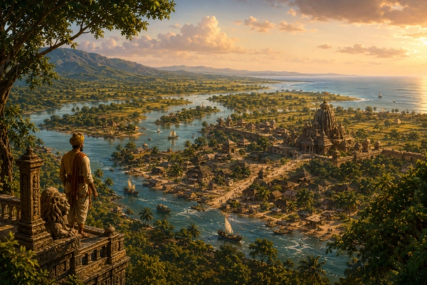
Mahabharata Geography — Tosala
Modern geographical correspondence: Coastal and central Odisha, India
Between the forested interior of Odisha and the Bay of Bengal lies a broad country created by rivers. The Mahanadi and its distributaries spread across fertile plains, the Daya winds past low hills and cultivated fields, and routes from the interior converge upon the coast. Within this landscape ancient Indian geographical traditions remembered a region called Tosala, also written Tosali, Toshala or Toshali. Its exact boundaries changed considerably with time, but its historical centre is generally sought in the coastal and central parts of present-day Odisha.
Tosala requires more caution than regions such as Kalinga because the evidence comes from several different periods. The name is known as that of a people and country in Sanskrit geographical traditions, while Tosali appears unmistakably as an important city and administrative centre during the Mauryan period. Later inscriptions expanded Tosala into a large territorial designation divided into northern and southern divisions. For a Mahabharata-geography reconstruction, it is therefore safest to place Tosala broadly in central and coastal Odisha, without pretending that its later historical boundaries existed unchanged in the epic age.
Tosala and the Mahabharata Tradition
Unlike Kalinga, which appears prominently within the narrative of the Mahabharata, Tosala is not described in the surviving core epic with the same political detail. This distinction is important. The Tosalas are nevertheless firmly embedded in the wider Sanskrit geographical tradition surrounding the epic and occur in sources closely connected with that literary world, including the Harivamsha, traditionally transmitted as a supplement to the Mahabharata, as well as the Atharvaveda Parisishta and several Puranic geographical catalogues. Historical studies of Odisha also recognise Tosala or Tosali as the name of both a people and a territory.
The geographical lists are especially revealing because they regularly associate the Tosalas with peoples such as the Kosalans, Utkalas, Mekalas, Dasharnas and other communities connected with eastern and central India. The Markandeya and other Puranic traditions place the Tosalas among regions associated with the Vindhyan sphere, suggesting that ancient Tosala was not conceived simply as a narrow strip of beach. Its connections reached inland towards the uplands and the routes linking Odisha with Dakshina Kosala and central India.
Tosala therefore belongs in our Mahabharata Geography series with an important qualification: its geographical identity is clearer from the wider epic-Puranic tradition and from subsequent historical evidence than from a detailed episode within the main Mahabharata narrative. This actually makes Tosala valuable, because it shows how ancient Indian geographical memory extended beyond the kingdoms that happened to receive long narrative treatment in the epic.
A Country Between the Interior and the Sea
The natural geography of central coastal Odisha helps explain why Tosala could grow into an important political region. To the west and northwest rise the broken uplands and forested hill systems of Odisha, while eastward the land gradually flattens into the great river-built plains approaching the Bay of Bengal. The Mahanadi dominates the larger geographical system, but rivers such as the Daya, Kuakhai, Kathajodi, Kushabhadra and other channels divide the coastal country into an intricate network of fertile tracts.
For an ancient traveller, the landscape would have been defined as much by water as by land. Roads could disappear beneath seasonal floodwaters, while ferries and boats allowed people to cross broad channels or travel downstream. Villages clustered on slightly elevated ground, agricultural fields spread across the alluvial plains, and forested hills remained visible beyond the cultivated country.
This combination of productive farmland, river communications and access to the sea gave the region considerable strategic value. A political centre located here could draw resources from the hinterland while maintaining contact with coastal trade routes and settlements farther north and south.
The Daya River and the Landscape Around Dhauli
One of the most evocative landscapes connected with Tosali lies around Dhauli, just south of modern Bhubaneswar. Dhauli rises conspicuously beside the Daya River amid a wide expanse of cultivated country. The Government of Odisha describes the hill as standing on the southern bank of the Daya in a landscape of green fields, and the site preserves one of Ashoka’s celebrated rock-edict complexes.
Even without the monuments of later centuries, the location would have been striking. From the hill, a traveller could survey river channels, fields and approaches running through the central coastal plain. The Daya connected this country with the larger Mahanadi deltaic system, while routes from the interior approached the coastal tract through nearby valleys and river corridors.
This helps explain why historians have repeatedly searched the Dhauli-Bhubaneswar region for ancient Tosali. The combination of fertile land, abundant water, defensible elevated positions and connections to both inland and coastal routes made the area a natural centre of political authority.
Tosala and Tosali — Country and City
An important distinction must be made between Tosala, the wider country or people, and Tosali, the famous ancient urban centre. Ancient usage was not always perfectly consistent, and different forms appear in literary and epigraphical traditions, but evidence shows that Tosala could denote a territory while Tosali functioned as a major city within the wider region. The Buddhist Gandavyuha, for example, remembers a country called Amita-Tosala with a city named Tosala.
By the Mauryan period, Tosali had become politically important enough to serve as a major administrative headquarters following Ashoka’s conquest of Kalinga. Odisha’s official state history records Tosali as the headquarters of a Mauryan viceroy and an important judicial authority within the conquered province.
This later evidence cannot simply be projected backwards into the period represented by the Mahabharata. It does, however, demonstrate that the geographical zone remembered as Tosala developed into one of the principal administrative and urban regions of ancient eastern India.
Where Was the City of Tosali?
The exact location of ancient Tosali remains one of Odisha’s fascinating archaeological debates. Earlier scholars frequently identified it with Dhauli, largely because Ashoka’s Separate Kalinga Edicts were engraved there and because the inscription addresses officials associated with Tosali. Dhauli also preserves evidence of an important early historic settlement.
The discovery and excavation of Sisupalgarh, only a short distance away, complicated the picture. Sisupalgarh revealed an immense fortified urban settlement with substantial archaeological remains, leading many scholars to propose that the fortified city itself was Tosali while Dhauli occupied its surrounding administrative or sacred landscape. The Archaeological Survey’s early excavation report, however, explicitly cautioned that the identification remained uncertain because no decisive inscription naming the city had been found.
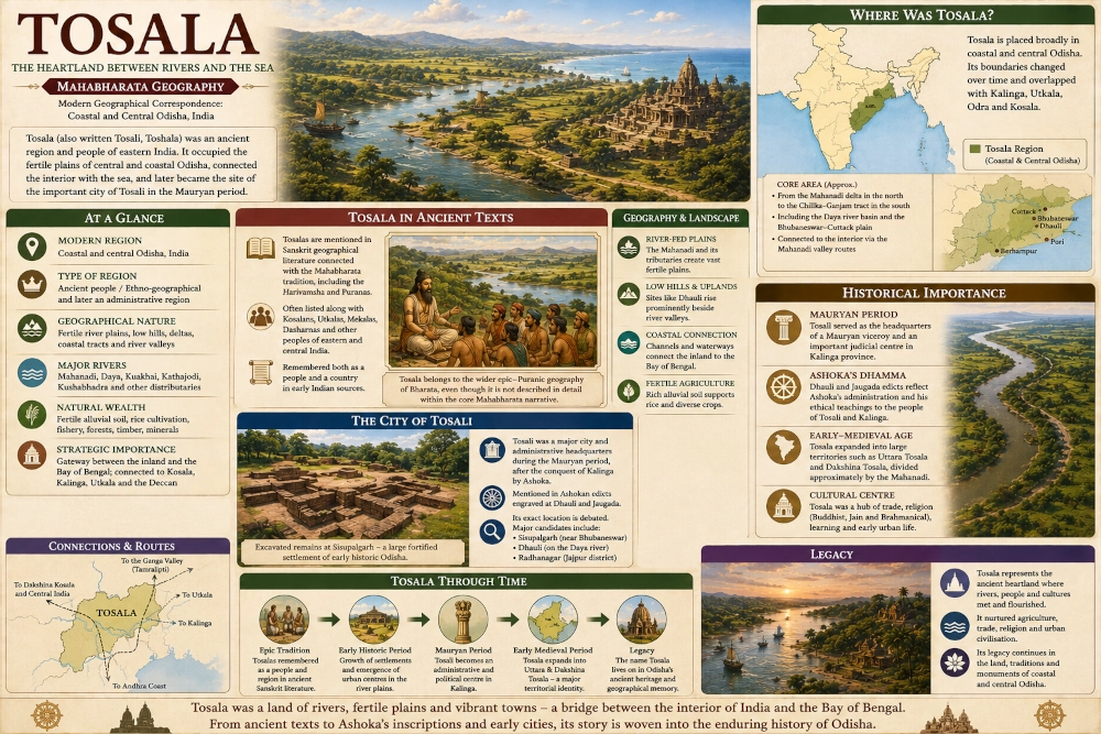
More recent research has also proposed Radhanagar in Jajpur district as another candidate for Tosali because excavations there have revealed a substantial early historic fortified settlement with Mauryan-period material. The debate therefore remains open, and a responsible reconstruction should not depict one archaeological site as unquestionably proven to be Tosali.
What can be stated with much greater confidence is that Tosali belonged somewhere within the wider central and northern coastal Odisha world, and that the Bhubaneswar-Dhauli-Sisupalgarh zone was one of the great early urban landscapes of that region.
The Mahanadi as Tosala’s Great Northern Artery
The Mahanadi is essential to understanding Tosala. After travelling eastward through the interior of Odisha, the river reaches the lower country and divides into numerous channels before entering the Bay of Bengal. These waterways created enormously fertile plains capable of sustaining dense agricultural settlement.
The river also connected Tosala with regions much farther inland. Travellers moving westwards could follow the Mahanadi corridor towards the uplands and eventually Dakshina Kosala, while those moving eastwards approached the delta and coastal routes. This geographical relationship helps explain why ancient literature so frequently places Tosala and Kosala within the same broader geographical conversation even though they were regarded as distinct regions. Scholars studying the ancient name have repeatedly noted Tosala’s association with Dakshina Kosala in Sanskrit sources.
This was therefore not an isolated coastal country. Tosala stood at the eastern end of one of the major natural corridors connecting central India with the Bay of Bengal.
Tosala, Kalinga and the Problem of Ancient Boundaries
The relationship between Tosala and Kalinga is especially complicated. During the Mauryan period, Tosali functioned within the conquered Kalinga province, and Odisha’s official historical account describes it as a major Mauryan headquarters there. Other Sanskrit traditions, however, distinguish Tosala from Kalinga as separate geographical names.
There is no contradiction if we remember that ancient regional names could operate at several levels simultaneously. Kalinga could describe a large political realm while Tosala represented one of its constituent geographical regions. At another period, a powerful Tosala-based dynasty could extend the Tosala name across areas formerly described differently.
For our reconstruction, Kalinga should remain the broader southeastern coastal power, particularly associated with southern Odisha and northern Andhra Pradesh, while Tosala is placed more centrally within Odisha’s coastal and lower-river country. The transition between the two should be understood as a broad frontier rather than a surveyed border.
Tosala and Utkala
The relationship between Tosala and Utkala changed even more dramatically through time. Ancient and later sources sometimes distinguish the two, while early-medieval political geography eventually caused one name to replace or overlap the other in particular areas. Odisha historical scholarship notes that portions of coastal Odisha later called Utkala had previously been designated Toshala or Toshali.
This fluidity illustrates one of the most important principles of Mahabharata geography. Ancient Indian regional names were not equivalent to modern states. A country name could follow a people, a ruling dynasty or an administrative centre and consequently shift across the landscape over the centuries.
Tosala, Utkala, Odra and Kalinga should therefore be imagined as interlocking layers of Odisha’s historical geography, each prominent in different places and periods rather than as four permanently fixed blocks.
Tosala and Odra
Odra presents a similar case. Odra was originally associated with a people whose name eventually developed into Odradesa and ultimately Odisha, while Tosala became a major territorial designation in coastal Odisha during later historical periods. At different times their geographical spheres overlapped, and rulers could govern areas known by both terms.
In the reconstruction we are developing, Odra is more strongly connected with central inland Odisha and the Mahanadi corridor, while Tosala is centred farther east across the central and coastal plains. The two regions would have been linked continuously by the same rivers that carried people and goods from the uplands towards the sea.
Such distinctions help the reader understand ancient Odisha not as one kingdom repeatedly changing names but as a complicated mosaic of peoples, territories and political traditions that were gradually brought together.
A Fertile Agricultural Heartland
The central coastal plain could support substantial populations because its soils were continually renewed by river sediment. Rice cultivation naturally became one of the defining features of the wider Odisha lowlands, while pulses, oilseeds, vegetables and other crops could be grown according to season and local conditions.
The landscape would have changed dramatically with the monsoon. During the wet months, rivers expanded across low ground and wetlands filled with water. In the dry season, channels contracted and broad stretches of cultivated land reappeared.
An ancient Tosala village might therefore have stood slightly above the floodplain, surrounded by rice fields and ponds. Cattle moved along earthen tracks between settlements, while fishing boats worked the channels and ferries carried travellers across rivers. Storage of grain would have been essential because agricultural prosperity depended on managing both the generosity and unpredictability of water.
This fertile base helps explain how the region could eventually support major urban centres such as the one revealed archaeologically at Sisupalgarh.
Sisupalgarh and the Rise of Urban Life
Whatever its ancient name, Sisupalgarh demonstrates the extraordinary level of urban development achieved in the central Odisha plain. Archaeological excavations uncovered a vast fortified settlement laid out within imposing defensive walls, with gateways and substantial internal structures. Odisha archaeological research describes it as one of the major early historic population centres of coastal Odisha.
The city’s existence tells us something important about the surrounding landscape. Large urban centres cannot survive in isolation. They require agricultural surpluses, craftsmen, labourers, transport networks, water supplies and connections with smaller settlements.
The world around Tosali was therefore not simply forest and village. By the early historical period it had become part of a sophisticated settlement network capable of supporting fortified cities and long-distance exchange.
The Road from the Ganga Valley to the Deccan
Tosala’s location placed it close to routes linking northeastern India with the Deccan and the eastern coastline. Archaeological research on ancient Odisha describes road networks connecting Tosali with Vidisha and Ujjain, while coastal connections linked the Odisha region northwards towards Tamralipti and southwards towards ports along the eastern seaboard.
For a traveller moving across ancient India, Tosala therefore occupied an important junction. A merchant from the Gangetic plains could approach through eastern routes, while goods from central India could descend through the Mahanadi system. From the coastal plain, ships and coastal craft opened yet another network of movement.
This geography allowed ideas to travel alongside commodities. Brahmanical traditions, Jain communities and Buddhist institutions all became deeply rooted in Odisha, and major religious centres later emerged across precisely these interconnected routes.
Mahavira and the Tosalas
Jain tradition provides one of the most vivid literary memories of Tosali. The Avasyaka Niryukti describes Mahavira travelling through Tosali, where he encountered hostility and was reportedly mistaken for a thief before local Kshatriyas intervened. The details belong to Jain religious tradition rather than contemporary political documentation, but they clearly preserve Tosali as a recognisable country through which religious teachers travelled.
The story also suggests that Tosala stood within a larger network connecting the Gangetic world with eastern and southern India. Ascetics, merchants and travellers moved along many of the same pathways, depending upon villages and towns for food, shelter and protection.
The ancient geographical landscape was therefore filled with movement. Tosala’s roads carried more than armies and tribute; they carried religious traditions that would transform eastern India.
Ashoka and the Transformation of Tosali
The clearest historical light falls upon Tosali during the reign of Ashoka in the third century BCE. After the Mauryan conquest of Kalinga, Tosali became an important headquarters in the administration of the region. The Dhauli and Jaugada edicts were specifically designed to communicate the emperor’s administrative and ethical instructions to officials and inhabitants of the newly incorporated eastern territories.
The Dhauli landscape consequently became associated with one of the most famous transformations in Indian political memory: the aftermath of the Kalinga War and Ashoka’s increasingly strong emphasis upon Dhamma. Whatever the precise location of the city of Tosali, its officials operated within this intensely important political environment.
This makes Tosala unusual within our geographical series. It belongs to the literary geography inherited from ancient India, but it can also be followed into the firmly documented historical age through inscriptions and archaeology.
Uttara Tosala and Dakshina Tosala
By the early-medieval period, Tosala had expanded into a much larger territorial concept. Inscriptions refer to Uttara Tosala, or Northern Tosala, and Dakshina Tosala, or Southern Tosala. Historical studies generally regard the Mahanadi as an approximate dividing line between these two great divisions during parts of the early-medieval period.
At their widest, these later Tosala territories encompassed much of coastal Odisha, from northern districts southwards towards the Chilika and Ganjam regions. These boundaries belong many centuries after the world represented by the Mahabharata, so they should not be used as an epic-period map.
They nevertheless reveal the extraordinary longevity of the name. A geographical identity that began as the designation of a people and country eventually became the name of one of eastern India’s major political territories.
The Landscape of Tosala
To picture Tosala in its ancient setting, imagine approaching from the west after travelling through forested hill country. Gradually the valleys widen and the ground becomes flatter. Streams converge into larger rivers, and cultivated fields begin to stretch farther between settlements.
As the traveller continues east, water becomes increasingly dominant. Wide channels divide the plains, boats appear beside landing places, and villages rise upon slightly elevated ground above seasonal flood levels. The horizon opens, and the humid air begins to carry the influence of the Bay of Bengal.
Near the Daya River, low hills such as Dhauli rise unexpectedly from the plain. From their slopes the entire country can be surveyed: river, wetland, field, village and distant tree line forming one continuous green landscape.
Somewhere within this world stood the ancient centre remembered as Tosali. Whether its exact urban heart ultimately proves to have been at Dhauli, Sisupalgarh, Radhanagar or another connected site, the broader geographical setting remains unmistakably Odishan.
Tosala — The Meeting Ground of Odisha’s Ancient Regions
Tosala occupied one of the most strategically valuable landscapes in eastern India. It stood between the Mahanadi interior and the Bay of Bengal, between the cultural worlds remembered as Utkala and Kalinga, and between river valleys leading towards Dakshina Kosala and the maritime routes of the eastern coast.
Its connection with the Mahabharata tradition must be described carefully. Unlike Kalinga, Tosala does not possess a richly narrated role in the central epic story, and it would be misleading to invent one. The name belongs more clearly to the wider Sanskrit geographical tradition surrounding the epic, including the Harivamsha and Puranic catalogues, while archaeology and Ashokan inscriptions make Tosali increasingly visible as we move into the historical period.
For our geographical reconstruction, Tosala can therefore be placed broadly across coastal and central Odisha, particularly the fertile lower river country surrounding the Mahanadi-Daya system and the wider Bhubaneswar-Cuttack coastal plain. Its boundaries should remain deliberately approximate because the region changed substantially over the centuries.
Tosala’s importance ultimately came from its position. Rivers brought the wealth of the interior towards the plains, fertile soil supported growing settlements, roads connected the region with central and northern India, and the Bay of Bengal opened another world beyond the coast. From the older geographical memory of the Tosala people to the Mauryan headquarters of Tosali and the later territories of Uttara and Dakshina Tosala, the name remained anchored to one of the great crossroads of ancient eastern India.
In the history of Odisha, Tosala was therefore more than a forgotten country. It was a river-fed heartland where inland India approached the eastern sea, where villages grew into cities, and where an ancient regional name survived long enough to enter the age of inscriptions and archaeology.
You may also like
-
Odra — The Mahanadi Country of Forested Hills and River Valleys
-
Utkala — The River-Bound Eastern Land Between the Highlands and the Sea
-
Kalinga — The Eastern Kingdom Between Mahendra and the Sea
-
PM Vishwakarma Reaches 30-Lakh Artisan Registration Target as Scheme Completes Three Years
-
Mahishaka in the Mahabharata: The Ancient Southern Country of the Upper Kaveri
