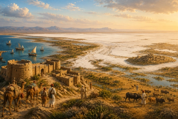
The ancient Kachchha or Kaccha region can be identified broadly with the modern Kutch region of Gujarat, a vast and distinctive landscape lying between Sindh, Rajasthan, Saurashtra and the Arabian Sea. Unlike several ancient geographical names whose modern locations remain uncertain, Kaccha has a striking continuity of name and landscape. The Mahabharata itself includes the Kacchas among the peoples of Bharatavarsha, while modern educational and historical sources identify this ancient name with present-day Kutch.
The geography makes the identification especially compelling. Kutch is surrounded by the Great Rann of Kachchh, Little Rann of Kachchh, Gulf of Kachchh and Arabian Sea, creating an unusual environment of salt marshes, grasslands, desert, islands and coastal plains. The Sanskrit word kaccha itself can mean marshy or low-lying land bordering water, a description remarkably suited to the region.
Yet Kachchha occupies a different place in the Mahabharata from kingdoms such as Chedi, Matsya or Saurashtra. The epic clearly names the Kacchas as a people or regional community, but it does not provide a securely identifiable Kachchha king, capital or royal dynasty connected with the central narrative. It is therefore more accurate to understand Kachchha as an ancient geographical and cultural region mentioned in the Mahabharata, rather than constructing a detailed royal history that the text itself does not supply.
Kachchha at a Glance
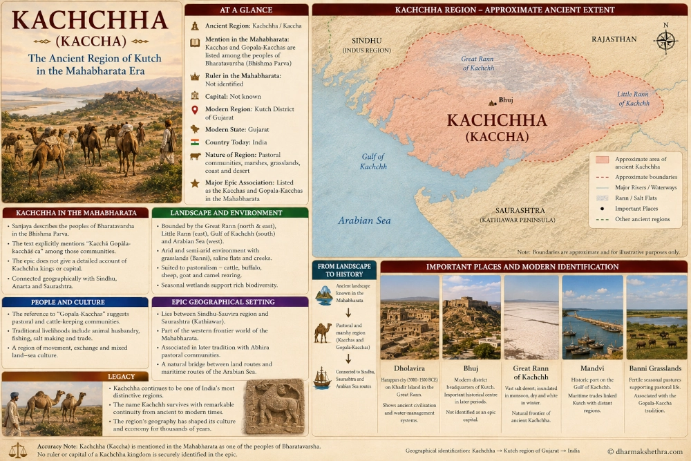
Ancient Kachchha corresponds broadly to the Kutch region of north-western Gujarat in western India. The Mahabharata uses the form Kaccha and also mentions the Gopala-Kacchas, suggesting a regional population that included pastoral communities. Modern Kutch lies between Sindh to the north-west, Rajasthan toward the north-east and Saurashtra across the Gulf of Kachchh to the south.
No capital of a Mahabharata-period Kachchha kingdom is securely identified in the epic, and no individual ruler can confidently be assigned to it from the relevant passages. Bhuj, today’s district headquarters, belongs to a much later historical political landscape and should not be projected backward as the capital of epic Kaccha.
The principal Mahabharata connection is therefore geographical. In the Bhishma Parva’s description of Bharatavarsha, the text explicitly lists the Kacchas and Gopala-Kacchas among the peoples inhabiting the subcontinent.
Where Was Ancient Kachchha?
The strongest modern identification places Kaccha in present-day Kutch in Gujarat. Modern Kachchh is an enormous region occupying India’s far western frontier. The district is bounded by Pakistan toward the north and north-west, Rajasthan and northern Gujarat toward the east, the Gulf of Kachchh toward the south and the Arabian Sea toward the west and south-west.
This location places ancient Kachchha between two major worlds repeatedly encountered in Mahabharata geography. To its north and north-west lay the lower Indus and Sindhu-Sauvira regions, while to its south lay Saurashtra and the broader Yadava landscape of western Gujarat.
Kachchha therefore occupied a natural transitional zone between the Indus world and Gujarat. Its location would have connected pastoral communities, inland caravan routes and coastal movement across the north-eastern Arabian Sea.
The Mahabharata Explicitly Names the Kacchas
The most important textual evidence comes from the Bhishma Parva, where Sanjaya describes the geography and peoples of Bharatavarsha to Dhritarashtra.
Among a long series of regional communities, the Sanskrit text states:
“Kacchā Gopālakacchāś ca…”
The passage lists the Kacchas and Gopala-Kacchas together with several other peoples of ancient India. The reference is significant because it demonstrates that Kaccha was recognised as a distinct geographical or ethnic name within the Mahabharata’s conception of Bharatavarsha.
This is stronger evidence than a later attempt to attach an ancient name to a modern place. The name itself occurs directly in the epic, while the geographical identification with modern Kutch is supported by the remarkable survival of the regional name.
The Government of India’s current NCERT social-science text similarly uses the Mahabharata’s geographical list and identifies Kaccha with today’s Kutch.
The Gopala-Kacchas and the Pastoral Landscape
The reference to Gopala-Kacchas is particularly interesting. The Sanskrit term gopala is associated with cattle keeping or cowherding, suggesting that at least some communities connected with Kaccha were known for a pastoral way of life.
Such an association fits the ecology of Kutch exceptionally well. Much of the region has historically supported pastoral rather than intensive agricultural economies because rainfall is limited and extensive tracts consist of salt marsh, semi-arid grasslands and seasonal wetlands.
The Banni grasslands, lying along the southern margin of the Great Rann, remain one of India’s most distinctive pastoral landscapes. Modern Kachchh continues to support cattle, buffalo, sheep, goat and camel-rearing communities, although today’s social landscape cannot simply be projected unchanged back into the epic period.
The Mahabharata’s pairing of Kacchas with Gopala-Kacchas nevertheless makes pastoralism an important part of reconstructing the ancient region’s character.
A Land Defined by Water and Desert
Kachchha is unusual because it can appear alternately as desert, wetland, grassland and island-like terrain depending on the season.
The Great Rann of Kachchh is an enormous saline plain lying north and east of the Kutch mainland. During the dry season, much of it becomes a brilliant white salt desert. During the monsoon, portions can become inundated by rainwater, river discharge and seawater, creating vast shallow wetlands.
The mainland itself is separated from surrounding regions by the Great Rann in the north, the Little Rann toward the east, the Gulf of Kachchh to the south and the Arabian Sea toward the west. Geological descriptions consequently treat Kutch as a distinctive geographical unit.
This unusual environment helps explain why the ancient term Kaccha became associated with the region.
What Does the Name Kaccha Mean?
The Sanskrit kaccha carries meanings associated with a bank, shore, marsh, watery soil or low-lying ground adjoining water. Traditional explanations of the name Kachchh similarly connect it with marshland and the peculiar physical characteristics of the region.
Another traditional explanation associates the shape of Kutch with a tortoise, or kachchhapa. The Kutch mainland can indeed appear tortoise-like on a map, surrounded by marshes and sea on several sides. The district administration itself records both the marshy-land interpretation and the association with the region’s distinctive physical form.
The linguistic evidence should not be forced into a single origin, but both traditions show how deeply the name is connected with geography.
Kaccha and Kaksha in the Geographical Lists
The Mahabharata’s Bhishma Parva contains another name, Kaksha, in an earlier portion of the same geographical survey. Some historical studies have treated Kaksha and Kaccha as related readings and connected them with the dry grasslands and marshy landscape of the Rann of Kutch.
Textual variants are common in long ancient works transmitted through numerous manuscript traditions, so it is better not to treat every occurrence of Kaksha automatically as Kutch. The explicit Kaccha reference later in the chapter provides the firmer foundation.
The important point is that the Mahabharata clearly knew a population called the Kacchas, and the identification with modern Kutch has been accepted in geographical discussions of the epic.
Kachchha Between Sindh and Saurashtra
Kutch’s location is essential to understanding its ancient significance.
To the north-west lay the Sindhu or Indus region, one of the great geographical zones repeatedly mentioned in early Indian literature. To the south, across the Gulf of Kachchh, lay Saurashtra, the Kathiawar Peninsula directly mentioned in the Mahabharata.
The Kutch district administration describes the region between Sindh and Saurashtra as historically associated with the Abhiras, another people directly known to the Mahabharata.
This broader regional setting appears in the Sabha Parva during Nakula’s western campaign before Yudhishthira’s Rajasuya. Nakula subdued the Sudras and Abhiras associated with the western Sarasvati region before continuing against other rulers and communities toward India’s western side. The passage does not specifically say that Nakula conquered Kaccha, but it demonstrates the network of western populations surrounding the Kutch-Sindh-Rajasthan landscape.
The Abhira Connection
The relationship between ancient Kutch and the Abhiras deserves particular attention because pastoral populations became important throughout the wider zone stretching from Sindh through western Rajasthan and Gujarat.
Historical studies place Abhira populations in parts of the lower Indus and western Indian region, while the Mahabharata places Abhiras among western communities encountered by the Pandavas.
The official history of Kachchh similarly notes an old tradition connecting the territory between Sindh and Saurashtra with the Abhiras.
This fits the broader pastoral character suggested by the Mahabharata’s Gopala-Kaccha reference. However, Kaccha and Abhira should not be treated as synonymous terms. One describes a geographical or regional population, while the other identifies a community whose settlements extended across a larger area.
No Secure Mahabharata King of Kachchha
One major difference between Kachchha and kingdoms such as Saurashtra, Chedi, Matsya or Magadha is the absence of a clearly identified royal figure.
Saurashtra has King Akriti in Sahadeva’s Rajasuya campaign. Chedi has figures such as Uparichara Vasu, Shishupala and Dhrishtaketu. Matsya has Virata. Magadha possesses the formidable Jarasandha.
Kaccha appears principally within the Mahabharata’s geographical catalogue of peoples rather than through a royal narrative. No passage securely establishes a particular king as ruler of Kaccha during the central events of the epic.
This should not be interpreted as evidence that the region lacked political organisation. It simply means that the Mahabharata does not preserve enough information for us to reconstruct its monarchy confidently.
No Secure Epic Capital
The same caution applies to the capital.
Modern Bhuj became one of Kutch’s most important political centres many centuries later and served as the capital of the historic Kutch state. Other settlements such as Mandvi, Lakhpat and Anjar also became important during later historical periods.
None can securely be called the Mahabharata-period capital of Kaccha.
For epic geography, the most responsible conclusion is therefore that the capital of ancient Kaccha remains unknown.
This distinction is important because modern maps often create artificial certainty by assigning later cities to much older kingdoms without textual or archaeological evidence.
Dholavira Reveals the Much Greater Antiquity of Kutch
Although Dholavira should not be presented as the capital of Mahabharata Kaccha, it proves something extremely important about the region: people had established sophisticated settlements in Kutch thousands of years before the historical periods in which many later regional kingdoms emerged.
Dholavira, situated on Khadir Island in the Great Rann of Kachchh, was one of the major urban centres of the Harappan civilisation. UNESCO dates its occupation broadly between 3000 and 1500 BCE and describes its fortified city, reservoirs, drainage systems and elaborate water-management infrastructure.
The archaeological site also produced evidence of craft production and long-distance trade linking the settlement with other Harappan centres and regions across the Arabian Sea.
Dholavira predates the textual world of the Mahabharata and should not be used to prove a particular event or character from the epic. Its significance lies instead in demonstrating the extraordinary antiquity of organised human settlement within the Kutch landscape.
Water Management in an Extreme Environment
Dholavira also illustrates a challenge that has shaped Kachchha for millennia: securing water in an arid region.
The ancient city’s inhabitants constructed an elaborate system of reservoirs and channels to collect and conserve water from seasonal streams. UNESCO regards this water-management system as one of the site’s outstanding features.
This environmental challenge continued throughout Kutch’s later history. Low rainfall, saline groundwater, seasonal wetlands and long dry periods encouraged populations to develop specialised ways of using limited resources.
The region’s distinctive ecology may therefore help explain why pastoralism, seasonal movement and dispersed settlement became such important features of Kutch over long periods.
The Great Rann as a Natural Frontier
Ancient political boundaries rarely resembled modern lines drawn across maps. In Kachchha, geography itself supplied enormous natural barriers.
The Great Rann stretches across the northern side of the Kutch mainland. Although it becomes more traversable during dry periods, seasonal inundation and the salt-covered terrain make movement difficult. To the south lies the Gulf of Kachchh, while the Arabian Sea surrounds the western coastline.
These features could simultaneously isolate Kachchha and connect it to distant regions. The Rann restricted easy overland movement, yet coastal waters opened routes toward Saurashtra, Sindh and the wider Arabian Sea.
Kachchha therefore stood at the meeting point of land routes, pastoral corridors and maritime networks.
The Gulf of Kachchh
The Gulf of Kachchh separates Kutch from much of the Saurashtra Peninsula and forms one of the defining maritime features of western Gujarat.
Its coastline contains creeks, tidal flats and natural harbours. In later history, ports such as Mandvi, Mundra and Kandla demonstrated the enormous commercial advantages of this geography. Modern government descriptions continue to emphasise Kutch’s long coastline and its natural access to maritime routes.
It would be inappropriate to project today’s port infrastructure directly into the Mahabharata period, but the underlying geography existed. Communities living in ancient Kaccha would have occupied a region naturally oriented toward both the sea and the western Indian interior.
The Banni Grasslands and the Gopala-Kacchas
Among the best landscapes through which to understand the Mahabharata’s Gopala-Kacchas are the Banni grasslands.
Banni lies between the Kutch mainland and the Great Rann. Seasonal wetlands, grasslands and semi-arid conditions have supported pastoral communities for generations. Animal husbandry remains a major part of Kachchh’s economy, with buffaloes, cattle, sheep, goats and camels particularly important.
There is no basis for claiming that modern Banni communities are directly identical to the Gopala-Kacchas of the Mahabharata. Nevertheless, the ecological continuity is remarkable. The ancient text associates Kaccha with a group whose very name suggests cattle keeping, while the same broad region continues to possess one of India’s best-known pastoral landscapes.
Kachchha Was Not Simply Part of Saurashtra
Because Kutch and Saurashtra are both located in modern Gujarat, they can easily become merged in simplified reconstructions of ancient geography.
The Mahabharata’s terminology argues against doing so.
Saurashtra appears separately and is associated principally with the Kathiawar Peninsula south of the Gulf of Kachchh. Kaccha appears as another named population. Anarta is also separately listed within the epic’s geographical world.
These names demonstrate that ancient western India contained multiple regional identities rather than a single political unit corresponding to modern Gujarat.
Kachchha should therefore be shown as the north-western region beyond the Gulf of Kachchh, while Saurashtra occupies the Kathiawar Peninsula farther south.
Kachchha and Anarta
Anarta represents another important neighbouring region in Mahabharata geography. It is strongly connected with western Gujarat and with the Yadava political world surrounding Krishna.
The Bhishma Parva lists Anartas separately from the Kacchas, confirming that the epic did not simply use the two names interchangeably.
Their exact ancient boundaries cannot be reconstructed with modern precision, but geographically Anarta is generally associated with northern and western parts of Gujarat, while Kaccha corresponds to Kutch.
This means that the northern Gujarat-Anarta zone probably formed one of Kachchha’s principal eastern and south-eastern neighbours.
Kachchha and Sindhu-Sauvira
Toward the north-west, Kachchha approached the world of Sindhu and Sauvira, regions repeatedly mentioned throughout the Mahabharata.
The ecological boundary between modern Kutch and lower Sindh has never been a simple straight line. The Indus delta, creeks, salt flats and seasonal waterways have shifted dramatically over time, creating a changing landscape between land and sea.
This fluid geography would have encouraged contact between populations on both sides. Kachchha therefore occupied a natural intermediary position between the Indian regions east of the Rann and communities connected with the lower Indus.
Its geographical identity cannot be understood fully without this north-western connection.
A Landscape That Changed with the Sea
Kachchha’s physical landscape has undergone considerable geological and hydrological change.
Government descriptions of the Rann note that it once formed part of a shallow marine environment and that siltation, river flows and changing coastlines contributed to the development of today’s salt-marsh landscape. During the monsoon, areas of the Rann can still become vast shallow sheets of water before drying again.
This helps explain why ancient terminology associated with marshes, shores and low-lying land became attached to Kaccha.
Modern political maps make Kutch look like a clearly defined block of land. Ancient travellers would have experienced something far more fluid: islands, creeks, marshes, seasonal water, grassland and sea.
Kachchha in the Wider Geography of Bharatavarsha
The significance of the Kaccha reference in the Bhishma Parva becomes clearer when seen within the purpose of the chapter itself.
Dhritarashtra asks Sanjaya to describe Bharatavarsha, the land over which so many kings are preparing to fight. Sanjaya responds by describing mountains, rivers and a huge number of peoples spread across the subcontinent.
The Kacchas appear within that enormous geographical vision alongside communities from many different parts of India.
Their inclusion demonstrates that the epic’s geographical imagination extended far beyond the Gangetic heartland of Hastinapura and Indraprastha. The distant marshes and grasslands of western Kutch belonged to the same wider world of Bharatavarsha.
Why Kachchha Matters in Mahabharata Geography
Kachchha does not produce one of the epic’s famous kings, nor does it become the setting for a decisive battle or dramatic episode. Its importance is subtler.
The region demonstrates the extraordinary geographical breadth preserved in the Mahabharata. The epic remembers not only large kingdoms with famous dynasties, but also distinctive frontier peoples, pastoral communities, coastal societies and geographically unusual regions.
The Kacchas lived on one of the western extremities of this world, in a territory shaped by salt marshes, grasslands, desert and sea.
Their appearance in the geographical list reminds us that Mahabharata-era Bharat was imagined as a mosaic of many different landscapes and populations.
Ancient Kachchha and Modern Kutch
The continuity between the ancient name Kaccha and modern Kachchh or Kutch is one of the most striking features of the identification.
Modern Kachchh remains geographically distinctive from the rest of Gujarat. It is India’s largest district by area, and more than half of its territory consists of saline desert associated with the Great and Little Ranns. Its coastline extends for hundreds of kilometres along the Gulf of Kachchh and Arabian Sea.
Bhuj is the principal modern urban centre, while places such as Mandvi, Mundra, Lakhpat and Kandla reflect later phases of Kutch’s maritime and political history. The Great Rann and Banni preserve the ecological character most useful for understanding why ancient writers regarded this as such a distinctive region.
The modern identification can therefore be expressed simply as Kaccha/Kachchha → Kutch region → Gujarat → India.
Dholavira, Bhuj and the Rann as Modern Reference Points
Three geographical references are especially useful for understanding the region today.
Dholavira, on Khadir Island, demonstrates the extraordinary depth of settlement in the Great Rann landscape. It belongs to the Harappan civilisation rather than the Mahabharata narrative, but its reservoirs, fortifications and evidence of long-distance exchange reveal how sophisticated societies adapted to Kutch’s difficult environment thousands of years ago.
Bhuj provides the clearest modern geographical reference for the Kutch mainland. Its importance as a capital belongs principally to later Kutch history rather than the epic period.
The Great Rann of Kachchh remains the defining physical landmark. Its enormous salt flats visually distinguish Kutch from almost every other Mahabharata geographical region that can be identified in modern India.
From the Rann to the Arabian Sea
Ancient Kachchha belonged simultaneously to desert and maritime worlds. The Rann formed its northern and eastern environment, while the Gulf of Kachchh and Arabian Sea opened the region toward the west and south.
This combination would have shaped movement, settlement and livelihood. Pastoral communities could make use of seasonal grasslands, while coastal populations could exploit fisheries and maritime routes. Movement toward Sindh connected Kachchha with the Indus world, while routes across or around the Gulf connected it with Saurashtra.
Few regions mentioned in the Mahabharata possess such an unusual combination of environmental zones.
The Legacy of Kachchha
Kachchha is one of the Mahabharata geographical names whose connection with modern India remains unusually visible. The epic’s Bhishma Parva explicitly remembers the Kacchas and Gopala-Kacchas, while modern scholarship and educational material identify Kaccha with present-day Kutch in Gujarat.
The epic does not preserve enough information to identify a Kachchha king or capital with confidence, and that absence should be respected. Kachchha’s importance lies instead in its identity as a distinct western region populated by communities living within one of the subcontinent’s most unusual environments.
The physical landscape helps bring the ancient reference to life. To the north stretched the saline expanses of the Rann. To the south lay the Gulf of Kachchh and Saurashtra. Beyond the north-western marshes began the world of Sindh and the lower Indus. Grasslands supported pastoral life, while the coast opened toward the Arabian Sea.
Long before the Mahabharata took written form, Dholavira had already demonstrated that this difficult landscape could sustain sophisticated civilisation. Thousands of years later, the region still carries essentially the same name.
When the Mahabharata lists the Kacchas among the peoples of Bharatavarsha, the landscape behind that ancient name can therefore be sought with considerable confidence in the Kutch region of modern Gujarat — a land of salt deserts, pastoral grasslands, islands and sea at the far western edge of India.
You may also like
-
Medieval Temple Relics Unearthed at Saptakoteshwar Site Reveal Forgotten Sacred Complex in Goa
-
Lata and the Mahabharata-Era Geography of Southern Gujarat: The Ancient Region Between the Mahi and Tapi
-
Saurashtra in the Mahabharata: The Ancient Kingdom of Gujarat’s Kathiawar Peninsula
-
From Mahabharata to Santoor: PM Modi’s Gifts Showcase India’s Civilisational Ties with Central Asia
-
Anarta in the Mahabharata: The Yadava Country of Northern and Central Gujarat
