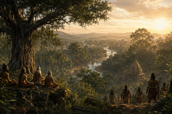
The Dandaka region, remembered more famously as Dandakaranya, occupied a distinctive place in the sacred geography of ancient Bharat. Unlike compact kingdoms such as Vatsa, Matsya or Chedi, Dandaka was associated with an enormous forested belt stretching across central and peninsular India. In modern geographical terms, its core is generally associated with the forest country extending through parts of eastern Maharashtra, Chhattisgarh, Telangana and southern Odisha, with some reconstructions extending farther into adjoining Andhra Pradesh.
The Mahabharata preserves Dandaka in several different contexts. It names the Dandakas among the peoples or territories subdued by Sahadeva during his southern Digvijaya for Yudhishthira’s Rajasuya. It also remembers Dandaka as a sacred forest during the great pilgrimage described in the Vana Parva. Elsewhere, while recounting the earlier story of Rama, the epic recalls Rama, Sita and Lakshmana residing in the Dandaka forest and connects the region with Janasthana and Ravana’s abduction of Sita.
Dandaka therefore belongs to the Mahabharata’s geographical world not merely as an isolated name, but as a vast southern forest zone lying between established kingdoms, pilgrimage routes and the expanding political geography of ancient India.
Dandaka at a Glance
| Feature | Description |
|---|---|
| Ancient Name | Dandaka / Dandakas |
| Forest Name | Dandakaranya |
| Nature of Region | Vast forest territory rather than a clearly bounded conventional kingdom |
| Approximate Modern Region | Parts of Maharashtra, Chhattisgarh, Telangana and Odisha |
| Wider Traditional Geography | Sometimes extended into adjoining Andhra Pradesh and other parts of central India |
| Major Landscape | Forests, plateaus, hills and river valleys |
| Important Rivers | Godavari system, Indravati and adjoining central Indian river networks |
| Mahabharata Association | Sahadeva’s southern Digvijaya |
| Vana Parva Association | Sacred forest and pilgrimage landscape |
| Earlier Epic Memory | Rama, Sita and Lakshmana in Dandaka |
| Political Identity | The Mahabharata refers to the “Dandakas” as a people or territory |
| Secure Mahabharata Capital | Not clearly identified |
| Country Today | India |
A Forest Realm Rather Than a Compact Kingdom
Dandaka requires slightly different treatment from many other entries in our Mahabharata geolocation series.
The Mahabharata sometimes refers to political regions through the names of their peoples, and this is how the Dandakas appear during Sahadeva’s campaign. At the same time, the Vana Parva explicitly remembers Dandaka as a forest, giving the region a geographical identity that extended far beyond a single city or royal court.
For this reason, it would be misleading to draw Dandaka like a neatly bounded kingdom centred on one undisputed capital.
The better reconstruction is a broad forest belt.
Its terrain would have included heavily wooded plateaus, river valleys, hill systems and difficult routes connecting northern and central India with the Deccan. The geographical memory survives in the name Dandakaranya, still used for a major forested region of east-central India. Modern descriptions commonly associate Dandakaranya with the Bastar region and adjoining areas of Chhattisgarh, Odisha, Telangana, Andhra Pradesh and Maharashtra.
Sahadeva’s Southern Digvijaya Reaches the Dandakas
The clearest political reference to Dandaka in the Mahabharata occurs in the Sabha Parva.
When Yudhishthira prepared to perform the Rajasuya Yajna, his brothers travelled in different directions to secure the allegiance and tribute of the rulers of Bharat. Sahadeva received responsibility for the southern campaign.
His route carries him through an extraordinary succession of kingdoms and geographical regions.
After entering the Narmada country, Sahadeva defeated Vinda and Anuvinda of Avanti. He proceeded toward Bhojakata, encountered Bhishmaka, moved through central and southern kingdoms and eventually brought King Nila of Mahishmati under Yudhishthira’s authority. He then continued through Saurashtra and secured recognition from Rukmin.
The text subsequently states that Sahadeva advanced farther south and reduced Surparaka, Talakata and the Dandakas to subjection.
This short statement is one of the most important Mahabharata references for reconstructing Dandaka.
It shows that the epic recognised the Dandakas as a distinct territorial or political group within the southern geography encountered by the Pandavas.
Dandaka Comes Under Yudhishthira’s Rajasuya Authority
Sahadeva’s campaign was not simply an expedition of conquest for territorial annexation.
The Rajasuya Digvijaya sought recognition of Yudhishthira’s paramount sovereignty. Kings and regions that accepted his authority supplied tribute and contributed to the political order necessary for the imperial sacrifice.
Dandaka therefore became part of the immense network of regions brought into Yudhishthira’s Rajasuya sphere.
The geographical sequence in the Sabha Parva is especially interesting because Sahadeva proceeds through regions linking central India, western India, the Deccan and the southern peninsula. The reference to the Dandakas appears before the narrative proceeds toward various coastal, Andhra, Kalinga and southern peoples.
Dandaka consequently appears as part of the transitional landscape through which the Pandava campaign moved from the interior toward southern and eastern peninsular India.
The Sacred Forest of Dandaka
Dandaka appears again in a completely different setting in the Vana Parva.
During the description of sacred pilgrimage places, the Mahabharata refers explicitly to the sacred forest of Dandaka. The pilgrimage narrative instructs the traveller to arrive at Dandaka and bathe there, treating the forest itself as a sanctified landscape.
This reference is extremely important.
Dandaka was not merely remembered as wild or inaccessible terrain. It had become part of the tirtha geography of Bharat.
Forests in the Mahabharata often possessed multiple identities simultaneously. They could be wildernesses containing dangerous animals and hostile beings, but they could also contain hermitages, sacred rivers, ascetic communities and places sanctified by earlier events.
Dandaka belonged strongly to this tradition.
Its forests separated kingdoms, but they also connected sacred sites.
Dandaka and the Memory of Rama
Although Dandakaranya is most extensively described in the Ramayana, the Mahabharata itself repeatedly remembers the story of Rama of Ayodhya.
During the Vana Parva, the epic recounts that Rama, accompanied by Sita and Lakshmana, went into exile and began to reside in the Dandaka forest. It then recalls the events leading to Sita’s abduction by Ravana from the region of Janasthana.
This is an important example of the Mahabharata preserving geographical memories shared with the Ramayana tradition.
For the Mahabharata’s audience, Dandaka was therefore not an unknown southern wilderness.
It was already famous.
The name evoked Rama’s exile, the forest hermitages, encounters with Rakshasas, Janasthana, the loss of Sita and the beginning of the chain of events that ultimately led Rama toward Lanka.
Dandaka and Janasthana
The tradition of Janasthana occupies an important place in the geographical memory of Dandaka.
The Mahabharata’s retelling of Rama’s story associates the Dandaka forest with the region from which Ravana carried Sita away. The larger Ramayana tradition gives Janasthana an even greater role, connecting it with Khara and the Rakshasa administration of the forest country.
Janasthana has often been associated with the Nashik region of Maharashtra, particularly because the Ramayana tradition places Panchavati on the Godavari there. However, it is important not to equate Janasthana automatically with the whole of Dandakaranya.
Dandaka was far larger.
Janasthana represented one important zone within the wider forest geography associated with the Dandaka tradition.
For mapping purposes, therefore, Nashik may appear as an important western epic reference, while the main shaded Dandakaranya region should extend much farther east through the forested interior.
The Geography of Dandakaranya
The ancient Dandaka landscape cannot be reconstructed with modern political borders.
Dandakaranya represented an ecological and cultural zone rather than a territory surveyed according to present-day administrative divisions.
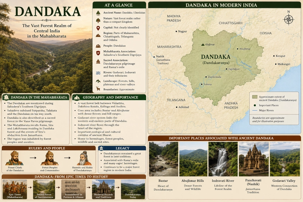
Modern geographical usage centres Dandakaranya largely upon the rugged forest country extending from the Abujhmar hills toward the Eastern Ghats, embracing substantial parts of Bastar and adjoining regions. The wider landscape reaches across parts of modern Chhattisgarh, Odisha, Telangana, Andhra Pradesh and Maharashtra.
For our Mahabharata map, the most useful core would include:
Gadchiroli – Bastar – Abujhmar – Dantewada – Sukma – Bijapur – Malkangiri – Koraput – adjoining northern Telangana
This should be treated as an approximate geographical reconstruction, not an exact ancient boundary.
The western side can extend into eastern Maharashtra, while the eastern side approaches the hill and forest zones of southern Odisha.
Bastar at the Heart of the Dandaka Landscape
Among all modern regions associated with Dandakaranya, Bastar in Chhattisgarh occupies one of the most prominent positions.
The Bastar plateau, Abujhmar forests and the valleys of the Indravati form a vast interior landscape of forests and hills. Modern descriptions frequently treat Bastar as a central component of Dandakaranya, and historical usage of the name has continued in this region into modern times.
This makes Bastar particularly useful as the geographical centre of a Dandaka infographic.
However, the ancient literary Dandaka should not be reduced to Bastar alone. Its remembered extent was broader and connected the forested interior with regions farther west and south.
The Godavari World
The Godavari river system forms one of the great geographical frameworks for understanding Dandaka.
Flowing eastward across the Deccan, the Godavari and its tributaries connect Maharashtra, Telangana, Chhattisgarh and Andhra Pradesh. Much of the wider Dandakaranya landscape lies within or close to this enormous river basin.
The Ramayana traditions associated with Panchavati strengthen the connection between Dandaka and the upper Godavari region, while the forests farther east are drained by major tributaries flowing through Bastar and Telangana. The modern geographical spread attributed to Dandakaranya closely follows this forested central-eastern Deccan environment.
The river therefore helped link western Dandaka traditions with the deeper forests of central India.
The Indravati and the Forest Interior
Another important river for reconstructing the core Dandakaranya landscape is the Indravati.
The Indravati flows across the Bastar region and eventually joins the Godavari. Around it lies some of the most rugged forest country of central India, including terrain associated with Abujhmar and the Bastar plateau.
This is exactly the type of landscape represented by the ancient idea of Dandakaranya: extensive forests cut by rivers and hills, with settlement corridors separated by large tracts of wilderness.
For a geographical illustration, the Indravati should therefore appear prominently alongside the broader Godavari system.
Dandaka Between Vidarbha, Kosala and Kalinga
The political importance of the Dandaka forest becomes easier to understand when the surrounding regions are considered.
To the northwest lay Vidarbha, an important kingdom repeatedly mentioned in the Mahabharata.
To the north and northeast were territories associated with Kosala, including the eastern or southern Kosala regions of central India.
To the east lay the approaches toward Kalinga.
To the south were the Andhra and Deccan regions.
Dandaka lay between these political worlds.
Rather than functioning only as an isolated wilderness, its forests formed a vast transitional zone separating and connecting some of ancient India’s most important cultural regions.
This also explains why Sahadeva had to deal with the Dandakas during his southern campaign. Control or submission of forest peoples and forest corridors would have been essential for any expedition attempting to move through peninsular India.
Forest Kingdoms in the Mahabharata
The Mahabharata makes it clear that political geography was not limited to large urban kingdoms.
During Sahadeva’s campaign, the epic repeatedly mentions forest kings, Nishadas, Pulindas and other communities living in terrain outside the major agricultural states. The same section that eventually names the Dandakas describes Sahadeva subduing various rulers and forest peoples along his route.
Dandaka should therefore be understood within this wider political world.
Its forests were not empty.
They contained communities, chiefs, sacred settlements, travelling routes and groups capable of appearing in the political records of the epic.
The phrase “forest realm” is consequently more appropriate than describing Dandaka as an uninhabited wilderness.
Dandaka and the Sacred Geography of Bharat
The Vana Parva’s description of Dandaka as a sacred forest places it within a much larger network of tirthas stretching across India.
For the Mahabharata, sacred geography connected mountains, rivers, lakes, forests and hermitages.
A pilgrim moving through Bharat did not travel only between cities.
Forests themselves could become destinations.
The explicit instruction to visit and bathe in Dandaka demonstrates that this massive southern woodland had acquired spiritual importance within the epic tradition.
The Dandaka landscape thus combines three identities:
a forest region, a political territory and a sacred landscape.
Few locations illustrate the layered geography of India’s epics more clearly.
Dandaka and Dandakaranya: Are They the Same?
The two terms are closely related but should be used carefully.
Dandaka can refer to the territory, people or geographical region.
Dandakaranya literally denotes the great forest associated with Dandaka.
Within epic geography, these concepts overlap considerably. As a result, modern discussions frequently use Dandaka and Dandakaranya almost interchangeably when referring to the ancient forest belt.
For our Mahabharata series, the title Dandaka should therefore identify the ancient region, while Dandakaranya should describe its characteristic forest landscape.
This preserves the terminology used by the epic while making the geography understandable on a modern map.
Dandaka on the Modern Map
For this series, Dandaka can be represented approximately as:
Dandaka → Dandakaranya → eastern Maharashtra, Bastar and southern Chhattisgarh → northern Telangana → southern Odisha → India
The strongest modern reference points include:
| Ancient Geographical Reference | Modern Approximation |
|---|---|
| Dandaka | Broad forest region of central and east-central India |
| Dandakaranya | Bastar and adjoining forest belt |
| Western extension | Gadchiroli and adjoining eastern Maharashtra |
| Central core | Bastar, Abujhmar, Dantewada, Bijapur and Sukma |
| Southern extension | Northern Telangana and adjoining Godavari country |
| Eastern extension | Malkangiri, Koraput and neighbouring southern Odisha |
| Important River System | Godavari |
| Important Interior River | Indravati |
| Ramayana-associated western reference | Janasthana/Panchavati tradition around Nashik |
| Country | India |
The map should use a large shaded forest zone rather than a compact political polygon.
Dandaka’s ancient borders were fluid and cannot be reconstructed with the precision of a modern state boundary.
How the Dandaka Map Should Be Presented
For our usual Mahabharata geographical infographic, Dandaka should be shown as a broad green or forest-gold shaded region spreading through the central Indian forest belt.
The map should prominently mark:
BASTAR / DANDKARANYA – central core
GADCHIROLI – western forest zone
ABUJHMAR – major forest and hill region
JAGDALPUR – modern reference point
DANTEWADA – central Dandakaranya
SUKMA – southern Bastar
BIJAPUR – western Bastar
MALKANGIRI – Odisha forest extension
KORAPUT – Eastern Ghats approach
GODAVARI – principal river system
INDRAVATI – major river through the forest core
NASHIK / JANASTHANA TRADITION – western epic association
Neighbouring ancient regions can be shown as:
VIDARBHA to the northwest
DAKSHINA KOSALA to the north and northeast
KALINGA toward the east
ANDHRA toward the south and southeast
A small India inset should highlight the forest belt across east-central India.
The caption should explain:
Dandaka was a vast forest region rather than a kingdom with fixed borders. The Mahabharata names the Dandakas during Sahadeva’s southern Digvijaya and also remembers the sacred forest of Dandaka. The shaded extent is approximate.
Dandaka’s Place in the Mahabharata
Dandaka occupies a fascinating position in the Mahabharata because the epic remembers it in several historical and sacred layers.
It appears first as a recognised territorial people, the Dandakas, whom Sahadeva brought under Yudhishthira’s authority during the southern Rajasuya campaign.
It appears again as the sacred forest of Dandaka, included among the pilgrimage places described in the Vana Parva.
The Mahabharata also connects the same landscape with the older epic memory of Rama, Sita and Lakshmana, recounting their residence in Dandaka and the events surrounding Sita’s abduction.
These references reveal why Dandaka deserves its own place in the geographical reconstruction of Mahabharata Bharat.
It was not merely wilderness beyond the kingdoms of the north.
Dandaka formed an enormous forest world situated between Vidarbha, Kosala, Kalinga, Andhra and the Deccan. Political expeditions crossed it. Forest peoples inhabited it. Sages sanctified it. Pilgrims remembered it. And the Mahabharata preserved its association with both Yudhishthira’s imperial ambitions and the ancient story of Rama.
On the modern map, its memory survives most strongly across the forested heart of eastern Maharashtra, Chhattisgarh, Telangana and southern Odisha.
In ancient tradition, however, Dandaka was larger than any one modern state.
It was Dandakaranya — one of the great forests of Bharat.
References
Mahabharata — Sabha Parva, Section XXXI
During Sahadeva’s southern Digvijaya, the Pandava prince subdues Surparaka, Talakata and the Dandakas, placing the region within Yudhishthira’s Rajasuya sphere.
Mahabharata — Vana Parva, Section LXXXV
The pilgrimage narrative refers explicitly to the sacred forest of Dandaka and includes it among the holy places to be visited.
Mahabharata — Vana Parva, Section CXLVI
While recalling the story of Rama, the epic states that Rama lived in the Dandaka forest with Sita and Lakshmana and connects the region with the events surrounding Sita’s abduction.
Geographical Note
Ancient Dandaka cannot be mapped with precise modern boundaries. Modern Dandakaranya is generally associated with a broad forested belt centred on Bastar and extending through adjoining areas of Chhattisgarh, Odisha, Telangana, Andhra Pradesh and Maharashtra. For this Mahabharata series, the shaded region should therefore be presented as an approximate cultural and geographical zone, with the core centred on the Bastar–Gadchiroli–Malkangiri–northern Telangana forest belt.
You may also like
-
New Excavations Begin at Kashmir’s 2,000-Year-Old Zehanpora Buddhist Site
-
Nishadha in the Mahabharata: The Kingdom of Nala in the Central Indian Landscape
-
Mekala in the Mahabharata: The Ancient Highland Kingdom of Amarkantak and the Maikal Hills
-
Anupa in the Mahabharata: The Ancient Narmada Kingdom of Mahishmati and the Maheshwar Region
-
Sarnath Joins UNESCO World Heritage List as India’s Civilisational Legacy Gains Global Recognition
