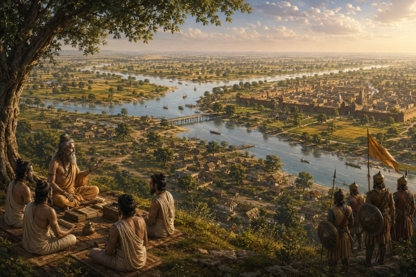
The ancient country of Panchala occupied an important place in the geographical, intellectual and political history of Bharat. Its territory lay mainly in what is now western and central Uttar Pradesh, extending across parts of the fertile plains between the upper Ganga and Yamuna river systems.
Panchala was closely connected with the Kurus and formed one of the principal centres of later Vedic civilisation. Its royal courts, settlements and centres of learning appear in the Vedas, Brahmanas, Upanishads, Puranas and the Mahabharata. In the epic tradition, it was the kingdom of King Drupada, Draupadi, Dhrishtadyumna and Shikhandi.
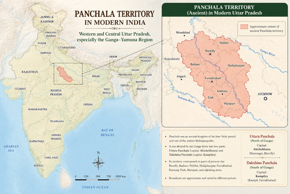
The boundaries of ancient Panchala changed over time and cannot be reproduced exactly on a modern political map. Historical reconstructions generally place its territory across the present districts of Bareilly, Badaun, Pilibhit, Farrukhabad and adjoining areas, with wider descriptions sometimes extending towards Bulandshahr, Aligarh, Kannauj and neighbouring portions of the Ganga–Yamuna plains.
Panchala in Modern Geography
In modern geographical terms, the ancient Panchala region lies entirely within the Republic of India, principally in Uttar Pradesh.
Its approximate territory may be understood through two major zones:
Northern Panchala, covering parts of the Rohilkhand plain, especially the region around Bareilly, Badaun and Pilibhit.
Southern Panchala, extending through the middle Ganga plain around Farrukhabad, Kampil, Kannauj and adjoining districts.
Ancient accounts commonly describe the Ganga as the broad geographical division between northern and southern Panchala. Northern Panchala had its capital at Ahichchhatra, while southern Panchala was governed from Kampilya.
The modern districts most frequently associated with the larger Panchala region include:
- Bareilly
- Badaun
- Pilibhit
- Shahjahanpur
- Farrukhabad
- Kannauj
- Etah
- Mainpuri
- Aligarh
- Bulandshahr
This list represents an approximate cultural and historical area. Panchala was never bounded by modern district lines, and its political influence varied across different periods.
A Land Shaped by the Ganga
The geography of Panchala was strongly influenced by the Ganga and its tributaries.
The Ganga crossed the larger territory and helped create the traditional distinction between Uttara Panchala and Dakshina Panchala. Rivers and seasonal channels deposited rich alluvial soil across the plains, making the region suitable for agriculture, cattle-rearing and permanent settlement.
The western part of the territory connected Panchala with the Kuru country around Delhi and Haryana. To the east lay the territories that eventually led towards Kosala, Kashi and the middle Ganga Valley. The region therefore occupied an important transitional position between the Vedic heartland of the northwest and the growing political centres farther east.
Its fertile plains supported wheat, barley, rice, pulses and livestock. River routes and overland roads connected its towns with the Yamuna corridor, the Himalayan foothills and the central Ganga plains.
Panchala consequently developed as both an agricultural region and a major route of cultural exchange.
Uttara Panchala: The Northern Kingdom
Northern Panchala was centred on Ahichchhatra, an ancient fortified settlement identified with the archaeological site near modern Ramnagar in Bareilly district.
The northern territory is generally associated with the plains of Bareilly, Badaun and Pilibhit and possibly extended towards the Himalayan foothills during periods of greater political strength.
Ahichchhatra was a major urban centre with fortifications, residential areas, streets and ritual structures. Archaeological investigations have revealed a long sequence of occupation at the site. Modern ground-penetrating radar research has identified buried walls, residential complexes, pathways, raised platforms and other structural remains at depths of approximately two to four metres.
The site contains cultural deposits extending across many centuries. Painted Grey Ware was discovered in its lower archaeological levels, while later occupation produced fortifications, sculptures, coins, temples and other remains.
The Archaeological Survey of India recognises the ancient fort and excavated remains of Ahichchhatra as a protected archaeological site.
Ahichchhatra’s location was strategically valuable. It stood near routes linking the Ganga plain with the Himalayan foothills and the regions farther west. Its defensive earthworks and extensive habitation indicate that it was more than a ceremonial capital; it was a substantial political and economic centre.
Dakshina Panchala: The Southern Kingdom
Southern Panchala was centred on Kampilya, identified with the modern town of Kampil in Farrukhabad district.
Kampilya occupies a prominent place in the Mahabharata. It is remembered as the capital of King Drupada and the location associated with Draupadi’s swayamvara. The district administration of Farrukhabad continues to identify Kampil as the ancient capital of southern Panchala.
The southern territory extended through the fertile country around Farrukhabad and Kannauj. Its position near the Ganga connected it with important river and land routes running across northern India.
Kampil also possesses significance in Jain tradition. It is revered as the birthplace of the thirteenth Tirthankara, Vimalanatha, and contains both Digambara and Shvetambara Jain temples. The town’s traditions therefore reflect the coexistence of Hindu, Jain and wider regional memories.
The presence of several religious traditions demonstrates the long life of Kampilya beyond the age of the Mahabharata. It remained a sacred and culturally important settlement even after Panchala ceased to function as an independent political kingdom.
Kannauj Within the Panchala Region
The celebrated city of Kanyakubja, later known as Kannauj, was located within the wider Panchala country.
Kannauj eventually rose to become one of the most important cities of early medieval northern India. Long before that period, however, it belonged to the historical geography associated with Panchala.
Official histories of Kannauj and Farrukhabad connect Kanyakubja, Kampilya and the surrounding region with ancient Panchala.
Its location near the Ganga gave Kannauj access to river transport and major overland routes. In later centuries, this geographical advantage enabled it to become a royal capital contested by powerful dynasties.
Kannauj’s later prominence was therefore built upon the same fertile and strategically connected geography that had earlier sustained Panchala.
Panchala in the Vedic World
Panchala was one of the major centres of later Vedic civilisation.
Along with Kuru, it formed the cultural region commonly described as Kuru-Panchala. This combined zone became closely associated with Vedic ritual, priestly learning, royal sacrifice and the transmission of sacred knowledge.
Academic studies describe the Kuru and Panchala kingdoms as the principal representatives of the Vedic-derived cultural world of northern India. Early Upanishadic traditions also depict scholars from the Kuru-Panchala region travelling to other centres such as Kashi and Videha.
The connection between the two regions was not merely geographical. Kuru and Panchala were linked through marriage, political competition, ritual traditions and the movement of teachers and students.
At certain times they were rivals. At others, their names were paired so closely that Kuru-Panchala came to describe a larger cultural heartland.
The growth of Panchala reflects the eastward expansion of Vedic society from Haryana and the Delhi region into the more extensively watered Ganga plains.
Panchala in the Mahabharata
Panchala is one of the most important kingdoms in the Mahabharata.
Its best-known ruler is King Drupada, who had studied with Drona during his youth. Their friendship later gave way to hostility after Drupada became king and rejected Drona’s claim to their earlier bond.
Drona trained the Kuru princes and asked them to defeat Drupada as his gurudakshina. Arjuna captured the Panchala ruler, after which Drona divided Drupada’s kingdom and returned a portion to him.
Seeking a son capable of defeating Drona, Drupada performed a sacrificial rite. From the sacred fire emerged Dhrishtadyumna, destined to confront Drona, and Draupadi, who became the wife of the five Pandavas.
Draupadi’s swayamvara was held at Kampilya. Princes and warriors assembled there to attempt the difficult archery challenge set for her marriage. Arjuna, disguised as a Brahmin during the Pandavas’ period of concealment, completed the task and won her hand.
Panchala later became one of the strongest supporters of the Pandavas. Drupada, Dhrishtadyumna, Shikhandi and the Panchala armies fought on their side in the Kurukshetra war.
Dhrishtadyumna served as commander of the Pandava army, while Shikhandi played a decisive role in the fall of Bhishma.
The kingdom was therefore not a minor background territory in the epic. Its royal family and military strength were central to the political balance of the Mahabharata world.
The Relationship Between Kuru and Panchala
Kuru lay mainly to the west of Panchala, across parts of present Haryana, Delhi and western Uttar Pradesh.
The two countries shared a long frontier and were connected through the upper Ganga–Yamuna plains. Their relationship alternated between cooperation, marriage alliances and political conflict.
The story of Drupada and Drona reflects competition between the two royal worlds. Draupadi’s marriage to the Pandavas later created a powerful alliance between Panchala and the Pandava branch of the Kuru dynasty.
This alliance had great strategic value. The Pandavas gained the support of a prosperous kingdom with trained armies and an influential royal house. Panchala, in turn, became closely connected with the claim of Yudhishthira and his brothers to the Kuru inheritance.
The eventual war at Kurukshetra was therefore partly shaped by the political union of the Pandavas and Panchalas.
Panchala as a Mahajanapada
By the period associated with Mahavira and the Buddha, Panchala was remembered as one of the sixteen Mahajanapadas, the major territorial states of northern India.
The Mahajanapada period witnessed the growth of fortified towns, coinage, trade networks, taxation and more organised systems of government. Panchala’s inclusion among these states demonstrates its continuing importance after the earlier Vedic and epic periods.
Academic and government sources identify the Mahajanapada as covering much of the Rohilkhand and central Doab regions of Uttar Pradesh.
Its political structure appears to have changed over time. It was originally associated with hereditary kings, but later traditions suggest that some form of oligarchic or corporate government may have emerged.
Panchala eventually came under the influence of expanding eastern powers. Official regional histories state that it was absorbed into the Nanda Empire during the fourth century BCE and subsequently became part of larger imperial systems.
Archaeology of the Panchala Country
The Panchala region contains numerous archaeological sites representing different phases of northern Indian history.
Ahichchhatra is the most extensive and prominent among them. Excavations and scientific surveys have revealed fortified enclosures, occupation levels, pottery, coins, sculptures and architectural remains.
Painted Grey Ware discovered at Ahichchhatra connects the site with the Iron Age material culture found across the wider Kuru-Panchala region. Archaeological Survey of India publications note that the ware was identified in the lower levels of Ahichchhatra during excavations conducted in the twentieth century.
Later levels show the development of urban life, craft production, trade and religious activity.
Coins associated with local Panchala rulers have also been discovered across the region. These provide evidence of political authority and economic organisation during the centuries preceding and following the beginning of the Common Era.
Archaeology cannot independently confirm every person or incident described in the Mahabharata. It does, however, demonstrate that the geographical world associated with Panchala contained ancient fortified settlements, agricultural communities and evolving urban centres.
Major Places in the Modern Panchala Region
Ahichchhatra, Bareilly District
The ancient capital of northern Panchala. Its fortified archaeological remains are protected by the Archaeological Survey of India.
Kampil, Farrukhabad District
Ancient Kampilya, capital of southern Panchala and the city associated with King Drupada and Draupadi’s swayamvara.
Kannauj
Ancient Kanyakubja, an important settlement within the wider Panchala country that later became one of northern India’s greatest royal capitals.
Badaun
Located within the traditional northern Panchala zone and close to the ancient political heartland around Ahichchhatra.
Bareilly
The modern district containing the site identified as the northern Panchala capital.
Farrukhabad
The modern district containing Kampil and several sites connected with ancient Hindu, Jain and Buddhist traditions.
Sankisa
An ancient settlement in present Farrukhabad district, particularly important in Buddhist tradition and protected as an archaeological site.
Panchala in Modern India
The entire historical heartland of Panchala lies within modern Uttar Pradesh.
The ancient country is now represented by fertile agricultural districts, towns, villages, archaeological sites, pilgrimage centres and expanding urban settlements.
The region continues to occupy a central place in India’s economy and culture. Its fields remain part of the productive Ganga plain, while places such as Kampil, Ahichchhatra, Kannauj and Sankisa preserve memories extending across several religious and historical traditions.
The Panchala identity no longer survives as a modern administrative division. Its legacy nevertheless remains embedded in literature, local traditions, archaeology and sacred geography.
A Living Geography of Bharat
Panchala was one of the lands in which the political organisation of ancient Bharat, the intellectual traditions of the Vedic age and the epic history of the Mahabharata came together.
Its northern capital at Ahichchhatra represented a fortified centre near the Rohilkhand plains. Its southern capital at Kampilya connected the kingdom with the Ganga and the central districts of Uttar Pradesh. Kannauj carried the region’s urban importance into later centuries.
The kingdom gave Indian civilisation some of its most enduring epic personalities—Draupadi, Drupada, Dhrishtadyumna and Shikhandi. Its scholars and royal courts contributed to the larger Kuru-Panchala world from which important Vedic and Upanishadic traditions were transmitted.
Today, Panchala rests securely within the geographical heart of India. Its former fields and cities are no longer divided among rival ancient kingdoms but united within Uttar Pradesh and the Republic of India.
The restoration of Ahichchhatra, the preservation of Kampil, continued archaeological research and greater public awareness can bring this forgotten geography back into national consciousness.
Panchala is not merely a vanished kingdom from an epic age. It is a living layer of the Indian landscape—a region where rivers, settlements, scholarship and sacred memory continue to connect modern Uttar Pradesh with the civilisational inheritance of Bharat.
Reference
INFLIBNET Centre, Government of India, “Mahajanapadas, Rise of Magadha, Nandas and the Invasion of Alexander” — geographical description of northern and southern Panchala and their capitals.
District Administration, Farrukhabad, Government of Uttar Pradesh, “History” and “Kampil” — Kampilya as the capital of southern Panchala and its cultural traditions.
District Administration, Kannauj, Government of Uttar Pradesh, “History” — Panchala’s approximate modern extent and place among the sixteen Mahajanapadas.
Satuluri, Sravanthi, et al., “Ground Penetrating Radar Investigations of Buried Remnants at Ancient Capital Cities of Panchala and Vatsa Kingdoms,” Journal of Archaeological Science: Reports, 2023 — archaeological and geophysical evidence from Ahichchhatra.
Archaeological Survey of India, archaeological publications and protected-monument records — Ahichchhatra’s excavated remains and Painted Grey Ware levels.
Geoffrey Samuel, The Origins of Yoga and Tantra, Cambridge University Press — Panchala and Kuru as major centres of the Vedic-derived cultural world.
You may also like
-
Sindhu: The Indus Kingdom of Jayadratha in the Mahabharata
-
Kuninda or Kulinda: The Himalayan Realm of the Mahabharata in Uttarakhand and Himachal Pradesh
-
Durga versus Mahishasura: Weapons, Battlefield Tactics and the Triumph of Shakti
-
Kuluta: The Kullu Valley Kingdom of the Mahabharata
-
Trigarta: The Kangra–Jalandhar Kingdom of the Mahabharata
