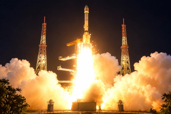
India has opened a new chapter in Earth observation with the successful launch of EOS-05, a spacecraft that will eventually give the country something its earlier remote-sensing satellites could not provide in the same way: persistent, high-frequency imaging from geosynchronous orbit.
The Indian Space Research Organisation confirmed that GSLV-F17 successfully placed EOS-05 into its intended Sub-Geosynchronous Transfer Orbit on September 4, 2026. The mission lifted off from the Second Launch Pad at the Satish Dhawan Space Centre in Sriharikota at 2:55 am. ISRO officially describes EOS-05 as a state-of-the-art Earth-observation spacecraft and India’s first-ever imaging satellite intended to operate from geosynchronous orbit.
That distinction is important. India has operated imaging and remote-sensing satellites for decades, beginning with the Indian Remote Sensing programme and later deploying increasingly capable Cartosat, Resourcesat, Oceansat and RISAT spacecraft. EOS-05 is therefore not India’s first imaging satellite overall. Its breakthrough lies in taking dedicated Earth imaging into the geosynchronous domain, where a satellite can repeatedly observe the same broad region instead of waiting for successive orbital passes.
From Periodic Passes to Persistent Observation
Most of India’s high-resolution Earth-observation spacecraft have operated in low-Earth or Sun-synchronous orbits. These orbits are extremely useful because satellites fly comparatively close to the surface and can obtain detailed imagery. Their limitation is temporal: a satellite moves rapidly around Earth and sees a particular location only when its orbit brings it overhead.
EOS-05 is designed around a different philosophy. Once its post-launch orbit-raising operations are completed and it reaches its designated geosynchronous operating region, it can maintain a broadly continuous view of India and surrounding areas. Instead of depending primarily on periodic overpasses, mission planners can obtain repeated observations of rapidly changing events.
This can transform the value of satellite imagery during situations where time matters almost as much as image resolution. Cyclones can develop rapidly, floods can spread across river systems within hours, forest fires can expand, landslides can isolate settlements and agricultural conditions can change across large areas. Frequent observation makes it easier to compare successive images and understand not simply where an event occurred, but how it is evolving.
ISRO has been developing this concept for years. Earlier official descriptions of its GISAT programme envisaged high-temporal-resolution imaging from geostationary orbit for monitoring disasters, natural hazards and other short-duration events. EOS-05 represents the successful arrival of that broader concept in orbit after an earlier attempt was lost during launch.
A 2.37-Tonne Satellite and an Important GSLV Mission
EOS-05 is also a substantial spacecraft. ISRO’s official GSLV-F17 mission brochure places its payload mass at approximately 2,367 kg. The 51.7-metre GSLV-F17 had a lift-off mass of around 420.5 tonnes and used three propulsion stages, culminating in the indigenous CUS15 cryogenic upper stage.
The injection orbit itself is worth understanding. GSLV-F17 did not place EOS-05 directly into its final operational geosynchronous orbit. It inserted the spacecraft into a Sub-Geosynchronous Transfer Orbit. ISRO’s pre-launch specifications listed a nominal perigee of about 170 km, an apogee of 28,934 km and an inclination of about 19.28 degrees. The spacecraft must subsequently use its onboard propulsion system to progressively reshape and raise this orbit before reaching its operational position.
That distinction is important because the launch on September 4 successfully completed the launch-vehicle phase, while spacecraft commissioning, orbit raising, payload checkout and calibration form the next stages before EOS-05 becomes fully operational.
GSLV-F17 was also the 19th flight of India’s Geosynchronous Satellite Launch Vehicle, giving ISRO another successful mission with the launcher and its indigenous cryogenic technology.
Completing a Mission India First Attempted in 2021
EOS-05 carries additional significance because India had tried to establish a similar geosynchronous Earth-imaging capability five years earlier.
On August 12, 2021, GSLV-F10 lifted off carrying EOS-03, also known as GISAT-1. ISRO intended that spacecraft to reach geostationary orbit and provide agile Earth observation. The launch, however, failed. ISRO later determined that the mission was aborted after an anomaly in the cryogenic upper stage; the Cryogenic Upper Stage ignition did not proceed as required.
EOS-05 therefore closes an important unfinished chapter. The value of the September 2026 success lies not merely in launching another remote-sensing satellite but in finally establishing the type of geosynchronous imaging capability that India had been working towards for years.
It also demonstrates one of ISRO’s defining institutional characteristics: unsuccessful missions are followed by failure analysis, corrective engineering and another attempt rather than abandonment of the objective.
Success After a Difficult Period for Earth-Observation Missions
The timing of the EOS-05 success adds to its importance.
ISRO’s PSLV-C61/EOS-09 mission of May 18, 2025 could not be accomplished after an observation during the vehicle’s third stage. EOS-09 was intended to carry a Synthetic Aperture Radar payload for all-weather Earth observation.
Then, on January 12, 2026, PSLV-C62 carrying EOS-N1 encountered an anomaly near the end of its PS3 third stage. ISRO subsequently initiated a detailed analysis of the event. EOS-N1, also listed by ISRO as ANVESHA, was not successfully placed into orbit.
The problems surrounding NVS-02 in 2025 were somewhat different and should not be confused with a launch-vehicle failure. GSLV-F15 precisely inserted NVS-02 into its intended transfer orbit. The difficulty occurred later aboard the spacecraft when orbit-raising operations could not be carried out because the propulsion system’s oxidiser-line pyro valve was not activated. ISRO investigated the issue through an Apex Committee and subsequently implemented corrective measures on later spacecraft.
Against that background, GSLV-F17’s successful injection of EOS-05 gives ISRO a valuable return to successful launch operations following the PSLV-C62 anomaly in January.
More Than a Weather Satellite
EOS-05 should not be viewed simply as another meteorological spacecraft. India’s Earth-observation infrastructure supports a much broader set of national requirements.
ISRO says satellite remote-sensing data are already used for agriculture, water resources, urban planning, rural development, mineral prospecting, forestry, environmental assessment, ocean-resource management and disaster management.
Adding high-temporal-resolution imaging can strengthen many of these applications. During floods, authorities could monitor how inundated regions expand or recede. In agriculture, repeated observations can improve assessments of crop and vegetation changes over large areas. Environmental agencies could follow major fires or extreme events. Infrastructure planners could receive more regularly refreshed geographical information.
There is also an obvious strategic dimension to having an indigenous satellite capable of frequently revisiting India’s neighbourhood. However, it is more accurate to describe EOS-05 as a national Earth-observation asset than simply as a “spy satellite.” Its civil, developmental, environmental, disaster-management and strategic applications can coexist.
A Different Kind of “Eye in the Sky”
The real advantage of EOS-05 is therefore not simply that it can take pictures from space. India has been doing that for nearly four decades.
What changes is the combination of position and persistence.
A low-orbit spacecraft may provide very detailed imagery but cannot remain over India continuously. A geosynchronous imaging satellite sacrifices proximity to Earth in exchange for an enormous field of view and the ability to return to target areas extremely frequently. Used together, the two classes of satellite become complementary: one supplies detailed observations while the other provides the temporal awareness needed to know where and when closer examination is required.
For a country the size of India—with a long coastline, Himalayan terrain, major river systems, enormous agricultural regions, dense cities and exposure to cyclones, floods, droughts and other hazards—that ability has considerable practical value.
EOS-05 Is Only Beginning Its Mission
The successful launch should consequently be regarded as the beginning rather than the completion of EOS-05’s operational journey. ISRO must now conduct its orbit-raising manoeuvres, establish the satellite in its designated geosynchronous region, verify spacecraft systems, commission the imaging payloads and calibrate the data before routine services can begin.
Nevertheless, the most dangerous portion of the launch sequence has been completed successfully. ISRO officially confirmed that GSLV-F17 accomplished its objective and placed EOS-05 into the intended transfer orbit.
Prime Minister Narendra Modi described the mission as an indication of the growing capabilities of India’s space sector and specifically highlighted EOS-05 as India’s first imaging satellite from geosynchronous orbit. He also pointed to the increasing contribution of Indian industry to the national space programme.
For ISRO, EOS-05 is therefore important on several levels. It establishes a new class of Indian Earth-observation capability, completes an objective that survived the loss of EOS-03 in 2021, demonstrates another successful GSLV flight and restores momentum after two unsuccessful PSLV Earth-observation launches.
Most importantly, it adds something genuinely new to India’s satellite architecture: an Indian eye in geosynchronous space capable of watching a vast region repeatedly rather than merely passing over it.
That could make EOS-05 one of the most consequential Earth-observation spacecraft ISRO has deployed.
References
Indian Space Research Organisation — GSLV-F17/EOS-05 Mission
Confirms successful injection, 19th GSLV flight, Sub-GTO and EOS-05 as India’s first imaging satellite from geosynchronous orbit. ISRO GSLV-F17/EOS-05 mission page
ISRO — GSLV-F17/EOS-05 Official Mission Brochure
Contains vehicle specifications, ~2,367-kg payload mass and target transfer-orbit parameters. ISRO official EOS-05 mission brochure
ISRO — GSLV-F10/EOS-03 Mission
Official record of the unsuccessful 2021 launch of the earlier geosynchronous Earth-observation mission. ISRO GSLV-F10/EOS-03 page
Press Information Bureau, Prime Minister’s Office — September 4, 2026
Official government statement following the successful GSLV-F17/EOS-05 launch. PIB official release on EOS-05
You may also like
-
Indian Scientists Discover How Rapidly Spinning Black Holes Produce High-Frequency X-Ray Oscillations
-
ISRO Completes Historic SPADEX Mission as Both Satellites Re-enter Earth’s Atmosphere After Successful Space Docking Experiments
-
Indian Scientists Discover Rare Accretion Disk Around Neutron Star 24,000 Light-Years Away
-
BARC Scientists Develop Indigenous Technology to Recover 90% of Lithium from Seawater
-
How Indigenous Indian Technologies Are Helping Aircraft and Trains Navigate Safely Through Dense Fog
