India is undertaking an extensive transformation of its maritime and inland water transport infrastructure through port modernisation, new deep-water terminals, river navigation projects and multimodal logistics corridors. From the Ganga and Brahmaputra river systems to Kerala’s backwaters, Goa’s navigable rivers and Odisha’s mineral transport corridors, a growing network of waterways is being developed to complement the country’s roads and railways while strengthening industrial connectivity and international trade.
The transformation is being implemented through major national initiatives, including the Sagarmala Programme, Jal Marg Vikas Project, National Waterways Development Programme and Maritime Amrit Kaal Vision 2047. These programmes bring together port infrastructure, cargo terminals, dredging, navigational facilities, coastal shipping and industrial connectivity. By creating more opportunities to move goods and passengers through navigable waterways, India is expanding its transport capacity while developing new economic connections between inland regions and coastal ports.
India’s major and non-major ports handled approximately 1,668 million tonnes of cargo during FY2025–26, reflecting the scale of maritime transport in the national economy. The country’s 12 operational major ports accounted for 915.17 million tonnes, recording annual growth of 7.06%. Inland waterways separately handled 218 million tonnes during the financial year, compared with approximately 18 million tonnes in FY2013–14. The expanding network illustrates the growing role of water transport in India’s logistics infrastructure.
India’s Maritime Infrastructure: Major Ports and Regional Networks
India’s coastline extends approximately 11,098 kilometres and supports an extensive system of commercial ports, fishing harbours, maritime terminals and coastal transport facilities. The country presently has 12 operational major ports administered by the Union Government, while a much larger network of non-major ports falls under the jurisdiction of state governments and maritime boards.
On the western coast, the principal major ports include Deendayal Port in Gujarat; Mumbai Port and Jawaharlal Nehru Port in Maharashtra; Mormugao Port in Goa; New Mangalore Port in Karnataka; and Cochin Port in Kerala. These ports handle commodities such as petroleum products, chemicals, containers, agricultural cargo, minerals and manufactured goods, connecting India’s western industrial regions with international shipping routes.
The eastern and southeastern coasts are served by V.O. Chidambaranar Port, Chennai Port and Kamarajar Port in Tamil Nadu; Visakhapatnam Port in Andhra Pradesh; Paradip Port in Odisha; and Syama Prasad Mookerjee Port in West Bengal, which encompasses Kolkata and Haldia port operations. These facilities support industrial sectors ranging from steel and thermal power to automobile manufacturing, container shipping and international commodity trade.
Alongside these major ports, state-regulated facilities such as Mundra, Pipavav, Dhamra, Krishnapatnam, Gangavaram and Vizhinjam contribute substantially to maritime trade. Their commercial operations demonstrate the complementary roles of public infrastructure, state-level port development and private investment in expanding India’s cargo-handling capabilities.
The government has also notified Vadhavan Port in Maharashtra and Galathea Bay Port in the Andaman and Nicobar Islands as major ports. These are development projects rather than additional operational members of the existing 12-major-port network. Their planned infrastructure will strengthen India’s future deep-water and international transshipment capabilities.
Sagarmala Programme: Developing Port-Led Economic Growth
The Sagarmala Programme, launched in 2015, provides a comprehensive framework for strengthening India’s maritime economy through port-led development. It seeks to improve the movement of cargo between industrial centres and maritime gateways by combining modern port infrastructure with efficient road, rail, coastal shipping and inland waterway connections.
Sagarmala operates through five major areas: port modernisation, port connectivity, port-led industrialisation, coastal community development, and coastal shipping and inland water transport. These components address different parts of the logistics network, from increasing cargo-handling capacity at ports to improving transport links with manufacturing centres and supporting economic activity in coastal communities.
According to the Ministry of Ports, Shipping and Waterways, the programme encompasses approximately 845 projects with an estimated investment of ₹6.06 lakh crore. As of March 24, 2026, 315 projects worth approximately ₹1.57 lakh crore had been completed, while 210 were under implementation and another 320 were at various planning stages. The completed projects included 120 port-modernisation initiatives that added more than 400 million tonnes of annual handling capacity, along with 106 road and rail connectivity projects.
Port modernisation under Sagarmala includes the mechanisation of cargo-handling facilities, construction of new berths, improvement of storage infrastructure, dredging to accommodate larger vessels and development of supporting utilities. Connectivity projects provide the road and railway infrastructure required to move cargo efficiently between ports, factories, warehouses and inland logistics centres.
The programme also supports coastal berths, passenger facilities, Roll-on/Roll-off terminals and inland waterway infrastructure. These investments help connect maritime transportation with regional economic activity and create opportunities for coastal communities, fishermen, transport operators and local businesses.
India’s National Waterways: From Five to 111 Declared Routes
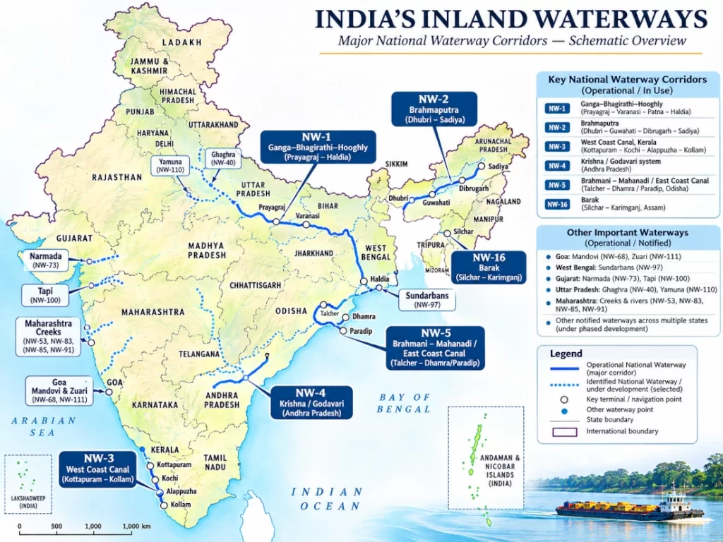
The National Waterways Act, 2016, established a framework for expanding inland water transport across India by declaring 111 National Waterways. These routes collectively extend approximately 20,187 kilometres across 23 states and four Union Territories, including rivers, canals, creeks and backwater systems.
A National Waterway designation identifies a route for potential development and navigation under the national framework. Actual transport operations depend on the availability of sufficient water depth, usable terminals, navigational infrastructure and suitable vessels.
As of 2026, the government has identified 32 National Waterways as operational, representing approximately 5,155 kilometres of navigable routes. The remaining waterways are at different stages of assessment, infrastructure development or future planning.
These operational waterways form several geographically distinct transport systems. The Ganga and Brahmaputra corridors connect northern and northeastern India with eastern ports, Kerala’s canal network supports passenger and regional cargo movement, and Goa’s river systems serve commercial and local navigation. Other waterways support transport in Gujarat, Maharashtra, Odisha, Andhra Pradesh, Uttar Pradesh and West Bengal.
The government recorded 218 million tonnes of cargo movement on National Waterways during FY2025–26, surpassing the earlier Maritime India Vision 2030 target of 200 million tonnes. This growth provides a foundation for expanding inland shipping into additional industrial and regional transport corridors.
National Waterway-1: The Ganga–Bhagirathi–Hooghly Corridor
National Waterway-1 is one of India’s most important inland water transport corridors. It follows the Ganga–Bhagirathi–Hooghly river system between Prayagraj in Uttar Pradesh and Haldia in West Bengal, passing through Bihar and Jharkhand.
The full designated waterway extends approximately 1,620 kilometres, while the principal Jal Marg Vikas development corridor covers approximately 1,390 kilometres between Varanasi and Haldia.
The route connects important population and industrial centres, including Varanasi, Patna, Sahibganj, Farakka, Kolkata and Haldia. It provides opportunities to move cargo between inland production regions and the ports of eastern India, creating an alternative transport route for appropriate commodities and consignments.
The principal cargo applications include bulk materials, industrial products, agricultural commodities, construction materials and containerised goods. The waterway can also accommodate specialised consignments that are difficult to transport by road because of their size or weight.
Cargo movement on NW-1 increased from 5.05 million tonnes in FY2014–15 to 16.38 million tonnes in FY2024–25. The development of terminals and navigational facilities has enabled more structured transport operations along the corridor.
The route also supports passenger boats, tourism and river cruises. Cruise services operate on parts of the Ganga system, although vessel size, river depth and bridge arrangements influence which stretches can accommodate larger cruise vessels.
Jal Marg Vikas Project: Creating a Modern Transport Corridor on the Ganga
The Jal Marg Vikas Project is the principal infrastructure initiative supporting commercial navigation on National Waterway-1. With an estimated project cost of approximately ₹5,061 crore, it has been developed with technical and financial assistance from the World Bank.
The project seeks to provide reliable navigational conditions between Varanasi and Haldia through fairway development, maintenance dredging, channel marking, navigational facilities and modern cargo terminals. The engineering approach includes maintaining suitable navigational depths across different river stretches to facilitate the movement of commercial vessels.
One of the project’s most important achievements is the development of multimodal terminals at Varanasi in Uttar Pradesh, Sahibganj in Jharkhand and Haldia in West Bengal. These facilities have been completed and are operational, providing cargo-handling infrastructure that links river transport with road and rail networks.
An intermodal terminal at Kalughat in Bihar has also been completed and brought into operation. The terminal strengthens cargo-handling infrastructure in the middle Ganga region and improves opportunities for moving freight between inland transport modes.
The project includes a new navigational lock at Farakka, which has been completed and commissioned. This facility improves vessel passage through an important section of the river system. Modernisation of the existing Farakka lock and development of the Balagarh intermodal terminal in West Bengal remained under implementation in the government’s August 2026 progress reporting.
Additional activities include the establishment of ship-repair facilities at Varanasi and Patna, development of river cruise infrastructure and continued improvements to navigational channels. These investments strengthen the supporting services required for sustained commercial operation.
The completed terminals demonstrate how the Ganga is being developed as a logistics corridor connecting inland economic centres with coastal maritime facilities.
Arth Ganga: Connecting River Transport with Local Economic Activity
The Arth Ganga initiative, implemented as a component of the wider Jal Marg Vikas programme, extends the economic benefits of river development to communities living along the Ganga.
The initiative focuses on creating opportunities for farmers, artisans, small traders, fisheries enterprises and local producers to use river-based infrastructure for transportation and market access.
A major component is the development of community jetties that allow smaller vessels to transport passengers and local goods. These facilities connect riverbank settlements with nearby markets and other transport networks, supporting regional commerce alongside larger freight operations.
As of April 2026, 66 community jetties had been developed and made operational along National Waterway-1. Government reporting indicated that these facilities were serving approximately 1.22 lakh users daily, demonstrating their contribution to local mobility and economic activity.
The programme complements the development of major cargo terminals by extending water transport infrastructure to smaller communities. This creates a more inclusive network in which national logistics corridors and local transport requirements can develop together.
National Waterway-2: Brahmaputra Connects Assam with Regional Trade Routes
National Waterway-2 follows the Brahmaputra River between Dhubri and Sadiya in Assam, extending approximately 891 kilometres. The river is an essential transport corridor for communities and industrial activities across the Brahmaputra Valley.
Major navigation and cargo-handling locations include Dhubri, Jogighopa, Pandu near Guwahati, Tezpur, Neamati, Bogibeel and Dibrugarh. These facilities support river transportation across a region where road and railway connectivity must negotiate extensive river systems, floodplains and challenging terrain.
The development of NW-2 is particularly significant for the transport of bulk cargo, construction materials, agricultural products and other commercial consignments. The waterway also supports passenger services and river cruises, with the Guwahati–Neamati stretch identified as an operational cruise corridor.
The Inland Waterways Authority of India has developed floating terminals and permanent infrastructure at important locations. Recent completed projects include a high-level jetty at Pandu, improvements at Dhubri, an inland water transport terminal at the Jogighopa Multimodal Logistics Park and a cargo-cum-tourist terminal at Bogibeel.
Further investments include navigational improvements between the Bangladesh border and Pandu, a ship-repair facility at Pandu and new tourism and cargo infrastructure at other locations in Assam.
These projects are strengthening the Brahmaputra as both a regional transport system and an important component of India’s wider northeastern logistics network.
National Waterway-16: Barak River Supports Southern Assam
National Waterway-16 follows the Barak River in southern Assam and forms an important water transport corridor for the Barak Valley.
The river system supports movement through areas around Silchar, Badarpur and Karimganj, providing an additional connection for passenger and commercial transportation.
The government has undertaken improvements to existing inland water transport infrastructure at Badarpur and Karimganj, including terminal renovation and associated facilities. These works strengthen the availability of transport infrastructure in a region where river connectivity has historically supported trade and local mobility.
NW-16 is also significant because of its potential connection with the Indo-Bangladesh Protocol routes, which provide a framework for cross-border movement between Indian and Bangladeshi waterways.
Developing reliable river connections can help integrate the Barak Valley more closely with Assam’s wider transport network and the maritime facilities of eastern India.
Indo-Bangladesh Protocol Routes: International Connectivity through Rivers
The Protocol on Inland Water Transit and Trade between India and Bangladesh enables designated vessels to navigate agreed river routes through the territories of both countries.
This arrangement is particularly important for connecting India’s northeastern states with the Ganga–Brahmaputra system and eastern maritime ports.
The protocol routes provide opportunities to move cargo between NW-1, NW-2 and NW-16 through navigable waterways in Bangladesh, reducing dependence on longer overland transport routes for suitable consignments.
Important Indian terminals associated with this wider network include Haldia, Kolkata, Dhubri, Pandu and facilities serving southern Assam. Protocol arrangements also support connectivity involving the Gumti River and Sonamura terminal in Tripura.
The system creates opportunities for trade in construction materials, industrial products, agricultural commodities and other cargo transported by inland vessels.
India has also undertaken efforts to strengthen navigational facilities, terminal infrastructure and cross-border transport arrangements supporting these routes. The development of scheduled services under the Jalvahak initiative is intended to make inland cargo transport more predictable and commercially accessible.
The Indo-Bangladesh waterways framework therefore serves both a logistics function and a broader regional connectivity role, linking India’s northeastern economy with eastern ports and international shipping networks.
National Waterway-3: Kerala’s West Coast Canal
Kerala possesses one of India’s most distinctive inland waterway networks, comprising interconnected canals, rivers, lakes and backwaters. National Waterway-3 forms a central part of this system, extending between Kottapuram in Thrissur district and Kollam through the West Coast Canal and associated navigational channels.
The waterway links several important locations, including Aluva, Maradu, Vaikom, Thanneermukkom, Alappuzha, Thrikkunnapuzha and Kayamkulam. It supports regional passenger movement, inland cargo transport, tourism and connections with Kochi’s port and industrial infrastructure.
The Inland Waterways Authority of India has developed nine permanent inland water transport terminals with storage facilities at Kottapuram, Aluva, Maradu, Vaikom, Thanneermukkom, Alappuzha, Thrikkunnapuzha, Kayamkulam and Kollam.
Two Roll-on/Roll-off terminals at Bolgatty and Willingdon Island support vehicle transportation across the Kochi harbour area. The service uses purpose-built vessels manufactured by Cochin Shipyard and operated through Kerala’s inland navigation system.
The waterway also accommodates passenger boats and houseboats, supporting both everyday transportation and Kerala’s tourism economy.
To improve safe navigation, the government has installed navigational buoys and other aids along the route. Additional projects involve waterway maintenance, jetty development, bridge improvements and navigation infrastructure.
National Waterway-3 is particularly important because it demonstrates the integration of inland navigation with an established regional economy, combining commercial transportation, passenger mobility and tourism within a single waterway system.
National Waterways-8 and 9: Alappuzha and Kottayam Canal Networks
Kerala has two additional operational National Waterways that complement the West Coast Canal.
National Waterway-8 covers the Alappuzha–Changanassery canal system, which supports passenger ferry services and houseboat operations in the central Kerala backwater region.
National Waterway-9 follows the Alappuzha–Kottayam–Athirampuzha canal system, providing another navigable connection through the state’s inland water transport network.
These waterways serve regions where settlements, agricultural lands and commercial activities are distributed across interconnected canals and backwaters. Passenger transport remains a particularly important application because waterways provide direct connections between communities separated by rivers, canals and lakes.
Government investment has included navigational aids, fairway maintenance and improvements to supporting infrastructure. These works contribute to the continued operation of inland transport services and the development of tourism-related navigation.
Kerala’s waterway network also offers opportunities for greater integration with Kochi’s maritime infrastructure and regional transport systems.
Kochi Water Metro: Modern Urban Passenger Transportation
The Kochi Water Metro represents a separate but complementary development in Kerala’s inland water transport ecosystem.
Unlike the larger national waterway projects primarily associated with regional navigation and freight, Kochi Water Metro is an urban public transport system designed to connect island communities and waterfront settlements through modern passenger vessels.
The project employs electric-hybrid boats and purpose-built terminals to integrate water transport with the metropolitan mobility network.
Its development demonstrates the application of modern vessel technologies, passenger information systems and organised services to urban inland transportation.
The Water Metro complements Kerala’s traditional ferry network and illustrates how waterways can contribute to reducing dependence on road transportation in cities with extensive navigable water bodies.
Together, National Waterways-3, 8 and 9 and the Kochi Water Metro highlight Kerala’s importance in India’s inland navigation sector.
Goa: Mandovi, Zuari and Cumberjua Waterways
Goa has three operational National Waterways that form part of its commercial and passenger transport network.
National Waterway-68 follows the Mandovi River, National Waterway-111 covers the Zuari River, and National Waterway-27 encompasses the Cumberjua canal system.
These waterways provide important navigational connections within Goa and support activities associated with inland transport, tourism, regional commerce and maritime logistics.
The Mandovi and Zuari systems have historically supported the movement of mineral cargo, particularly iron ore, although cargo patterns have varied with changes in mining and industrial activity.
The waterways also accommodate tourist vessels and local passenger services, connecting riverfront destinations with Goa’s wider coastal economy.
The government has developed floating jetties and other infrastructure across these waterways. Official reporting in July 2026 confirmed the completion of a programme involving ten jetties across the Mandovi, Zuari and Cumberjua systems.
Their continued development supports both commercial transportation and the tourism economy of Goa.
National Waterway-4: Krishna–Godavari Transport System
National Waterway-4 covers important sections of the Krishna and Godavari river systems and associated canal networks in Andhra Pradesh and Telangana.
The waterway has significant potential for linking agricultural regions, industrial centres and inland transport terminals with the broader coastal economy.
Development activities have included the establishment of Roll-on/Roll-off terminals at Muktyala and Harichandrapuram, construction of floating jetties and improvements to river navigation facilities.
The government has also undertaken land acquisition and related infrastructure development at selected terminal locations.
Passenger ferry services operate at certain points along the designated system, while the development of facilities for commercial cargo remains an important component of the wider programme.
The availability of navigable sections across the Krishna and Godavari systems creates opportunities for regional freight movements involving agricultural products, construction materials and industrial commodities.
The programme is being developed in phases, with operational activities and infrastructure works concentrated on selected stretches rather than the entire designated waterway.
National Waterway-5: Odisha’s Emerging Mineral Transportation Corridor
National Waterway-5 is one of India’s most important strategic inland waterway development projects because of its potential to connect mineral-producing regions with industrial centres and maritime ports.
The designated waterway includes sections of the East Coast Canal, Matai River, Brahmani–Kharsua–Dhamra river system and associated Mahanadi delta waterways in Odisha.
Its development is intended to connect the mineral-rich Talcher and Angul regions with industrial centres such as Kalinganagar and the ports of Paradip and Dhamra.
These regions are important to India’s coal, steel, power generation and mineral-processing industries. Transporting bulk cargo through inland waterways offers an alternative logistics arrangement for suitable industrial consignments.
The Union Budget 2026–27 identified the development of NW-5 as a significant priority, with particular emphasis on facilitating mineral transportation and strengthening port connectivity.
The government has undertaken initial development activities along the Talcher–Dhamra–Paradip corridor, including surveys, navigational improvements and infrastructure planning.
The proposed integration of river transport with port infrastructure offers opportunities to move industrial cargo more efficiently between inland production centres and maritime terminals.
NW-5 is listed among India’s operational National Waterways, but the complete industrial freight corridor remains under phased development. Its long-term programme includes additional navigational improvements and terminal infrastructure intended to support larger-scale cargo transportation.
Other Operational Waterways across India
Beyond the better-known Ganga, Brahmaputra, Kerala and Goa systems, several other National Waterways support cargo, passenger or local navigation.
In Gujarat, operational waterways include the Narmada River under NW-73, Sabarmati River under NW-87, Tapi River under NW-100 and the Jawai–Luni–Rann of Kutch system under NW-48. These waterways provide a framework for navigation and regional transport activities, with development and commercial use varying between individual stretches.
Maharashtra’s operational waterways include the Amba River under NW-10, the Kalyan–Thane–Mumbai system under NW-53, Rajpuri Creek under NW-83, the Revadanda Creek–Kundalika system under NW-85 and the Shastri River–Jaigad Creek system under NW-91. These waterways serve coastal and estuarine regions where water transport can complement local road networks and maritime commercial activity.
In Odisha, additional operational waterways include the Baitarani River under NW-14, Budha Balanga under NW-23 and Mahanadi River under NW-64. Their development supports navigation, regional connectivity and the potential movement of industrial and agricultural cargo.
West Bengal’s additional waterways include the Ichamati River under NW-44, Jalangi River under NW-47, Rupnarayan River under NW-86 and Sundarbans waterways under NW-97. These routes support local transportation, river tourism and navigation through the extensive waterways of the lower Ganga delta.
In Uttar Pradesh, NW-40 covers the Ghaghra River, while NW-110 encompasses the Yamuna River. The government has completed selected passenger and tourism-related infrastructure works, including facilities associated with Ayodhya and the Mathura–Vrindavan region.
Bihar’s Sone River is designated NW-94, while Assam has additional operational waterways on the Dhansiri and Kopili river systems under NW-31 and NW-57.
The importance of these waterways lies in their regional applications. Some carry substantial commercial consignments, while others primarily facilitate passenger movement, tourism or limited local navigation. Their classification as operational therefore reflects the availability of usable transport activity rather than identical levels of cargo movement.
Inland Waterways and the Growth of River Cruise Tourism
Passenger services and river tourism form an increasingly important part of India’s inland navigation development.
River cruise operations are established on important stretches of National Waterway-1, particularly within the Ganga system. The corridor connects major cultural destinations and provides opportunities for tourism involving historical towns, riverfront attractions and regional heritage.
On the Brahmaputra, river cruises operate between Guwahati and Neamati, allowing visitors to experience the riverine environment and cultural landscapes of Assam.
Kerala’s National Waterway-3 and National Waterway-8 support passenger ferries and houseboat services, reflecting the state’s longstanding association with backwater tourism.
The Sundarbans waterways in West Bengal also accommodate river cruise operations, providing access to destinations associated with the region’s distinctive deltaic landscape and natural heritage.
The government has undertaken the development of passenger terminals, floating jetties and navigational facilities to support these activities.
Tourism infrastructure is being developed alongside commercial cargo facilities, creating opportunities for the same waterway systems to serve multiple economic functions.
Jalvahak Scheme: Encouraging Freight Transportation on Rivers
The Jalvahak initiative has been introduced to increase the commercial use of inland waterways by providing incentives and supporting more predictable freight services.
The scheme provides incentives of up to 35% for eligible cargo transportation on specified inland waterway routes. It also supports scheduled cargo services on NW-1, NW-2 and NW-16 through arrangements involving Inland & Coastal Shipping Limited.
A central objective is to encourage cargo owners to consider river transport when planning freight movements between suitable destinations.
Scheduled services can provide businesses with greater certainty regarding vessel availability, transport arrangements and shipment planning. Such predictability is important when inland shipping is used as part of a larger logistics network involving road transport, railways and maritime ports.
The scheme complements infrastructure investment by encouraging commercial use of the terminals, vessels and navigational corridors already developed.
It also supports the expansion of private-sector participation in inland cargo transportation and associated services.
Coastal Shipping: Connecting India’s Ports along the Coastline
Coastal shipping involves the movement of cargo between ports located within India, allowing suitable freight to travel along the coastline rather than relying entirely on roads and railways.
This mode of transport is particularly relevant for bulk commodities such as coal, cement, petroleum products, fertilisers, steel and other industrial materials.
Coastal shipping connects the country’s western, southern and eastern maritime regions, including Gujarat, Maharashtra, Goa, Karnataka, Kerala, Tamil Nadu, Andhra Pradesh, Odisha and West Bengal.
The development of coastal berths, Roll-on/Roll-off infrastructure and improved port connections is creating additional opportunities for cargo movement between maritime terminals.
The government’s infrastructure reporting shows that coastal shipping cargo has increased considerably over the past decade, reflecting greater commercial use of coastal transport routes.
The Union Budget 2026–27 announced a Coastal Cargo Promotion Scheme to encourage the movement of suitable freight from roads and railways to coastal shipping and inland waterways.
The broader policy objective is to increase the combined modal share of coastal shipping and inland waterways from approximately 6% to 12% by 2047.
By strengthening coastal transportation, India is developing a more diversified logistics system in which maritime infrastructure supports both international trade and domestic industrial distribution.
Vadhavan Port: Maharashtra’s New Deep-Water Maritime Gateway
The Vadhavan Port Project in Palghar district, Maharashtra, represents one of India’s largest new maritime infrastructure investments.
Approved by the Union Cabinet in June 2024, the project has an estimated cost of approximately ₹76,220 crore. It is being developed as an all-weather, deep-draft port capable of accommodating large international cargo and container vessels.
The planned port will have a total cargo-handling capacity of approximately 298 million tonnes annually, including a proposed container-handling capacity of 23.2 million TEUs.
The development includes major marine infrastructure such as breakwaters, reclamation works, cargo terminals, transport connectivity and utility networks.
Dedicated road infrastructure will connect the port with NH-48 and the wider expressway network, while railway connectivity will support cargo movements between the port and inland industrial centres.
In April 2026, NHAI awarded a contract worth ₹2,360 crore for the construction of an approximately 32-kilometre access-controlled expressway linking Vadhavan Port with Tava village on NH-48. The project includes a tunnel, major bridges, interchanges and supporting structures.
The port is planned for development in phases, with the first phase targeted for operation around 2030.
Vadhavan is expected to strengthen India’s capacity to handle large container vessels and support maritime trade from the industrial regions of western and northern India. Its development complements the existing port network around Mumbai and Jawaharlal Nehru Port.
Vizhinjam International Seaport: Kerala’s Growing Transshipment Hub
Vizhinjam International Seaport near Thiruvananthapuram is an important development in India’s international container shipping infrastructure.
Located close to major international east–west shipping routes, Vizhinjam possesses favourable natural deep-water characteristics and is being developed as a major container transshipment facility.
The first phase of the port commenced commercial operations on December 3, 2024, with a designed annual handling capacity of approximately 1 million TEUs.
By the time the government announced the next stage of expansion in January 2026, the port had handled more than 1.43 million TEUs and demonstrated its ability to accommodate major international container vessels.
The Government of Kerala and Adani Vizhinjam Port Private Limited are implementing Phases II, III and IV together as an accelerated expansion programme.
The project includes extending the container berth to approximately two kilometres, expanding the breakwater, developing additional container yards and installing advanced container-handling equipment.
The expanded facilities are intended to support an operational throughput of up to 5.7 million TEUs annually, with completion targeted for December 2028.
The expansion is particularly significant because transshipment involves transferring containers between large international vessels and other ships serving regional destinations. Developing greater domestic transshipment capacity can strengthen India’s position in international shipping networks and create new opportunities for maritime commerce.
Vizhinjam also demonstrates Kerala’s growing importance in the development of advanced maritime infrastructure, complementing the state’s established port and inland waterway network.
Maritime Logistics and Digital Port Integration
India’s maritime modernisation extends beyond the physical construction of ports and waterways to include digital logistics systems that connect different transport modes.
The Maritime Single Window platform, Sagar Setu, has been developed to facilitate electronic information exchange between maritime stakeholders. It integrates vessel, cargo and logistics-related information with systems associated with customs, railways and other transport networks.
Digital integration helps improve the visibility of cargo movements and supports coordination between port operators, shipping companies, customs authorities and inland transport providers.
The government is also strengthening digital registration and administrative systems for inland vessels and crew. The Jalyan and Navic portals provide a centralised framework for inland vessel and personnel registration.
These developments support a more integrated transport network in which ports, railways, roads and waterways can exchange information and coordinate cargo movement more efficiently.
Modern logistics infrastructure therefore combines navigational improvements and physical transport facilities with digital systems supporting the movement of goods across different regions.
New National Waterways Identified for Development by 2031
The Union Budget 2026–27 announced the government’s intention to operationalise additional National Waterways over five years, building upon the existing network of 32 operational routes.
In August 2026, the Ministry of Ports, Shipping and Waterways identified 19 additional waterways for development, primarily to support passenger transportation, ferry services and river tourism.
The programme includes river systems in Jammu and Kashmir, Karnataka, Goa, Odisha, Kerala, Maharashtra, Tamil Nadu, Himachal Pradesh, Punjab and Uttar Pradesh.
In Jammu and Kashmir, the Jhelum, Chenab and Ravi rivers have been identified for development during FY2026–27. Karnataka’s Kabini and Sharavati rivers and Goa’s Sal River are also included in the first year’s identified programme.
Later phases include the Kali and Ghataprabha rivers in Karnataka, the Subarnarekha and Birupa-associated waterways in Odisha, and additional waterways in Goa.
Kerala’s AVM Canal and Kottayam–Vaikom Canal are identified for development during FY2028–29, providing further opportunities for passenger mobility and inland navigation.
The programme also includes the Savitri River and Vashishti system in Maharashtra, Bhavani River in Tamil Nadu, Sutlej River in Himachal Pradesh and Punjab, and Gandak River in Uttar Pradesh.
These proposed additions represent the next phase of inland water transport expansion, with emphasis on developing usable transport services in regions where rivers and canals can support local mobility and tourism.
Ports and Waterways as an Integrated National Transport Network
India’s maritime development strategy increasingly treats ports and inland waterways as interconnected components of a wider transport system.
Large maritime ports provide access to international trade routes, while inland terminals connect industrial centres and agricultural regions with navigable river corridors. Coastal shipping links ports within the country, and modern road and railway systems provide onward connections to manufacturing centres and consumer markets.
The Ganga–Haldia corridor demonstrates this integration by linking inland cities and cargo terminals with eastern maritime facilities. The Brahmaputra and Barak systems extend opportunities for river transportation in the Northeast, while Odisha’s NW-5 project seeks to connect mineral-producing regions with major ports.
Kerala’s waterways illustrate a different but equally important model in which passenger ferries, regional transport, tourism and maritime infrastructure operate within an interconnected coastal economy.
Goa’s Mandovi and Zuari rivers, Maharashtra’s estuarine waterways and the lower Ganga delta provide further examples of how India’s natural geography supports different types of water transportation.
The continuing development of these networks creates opportunities to diversify freight movement, strengthen regional accessibility and expand economic activity around ports and inland terminals.
Maritime Amrit Kaal Vision 2047 and India’s Long-Term Development
The Maritime Amrit Kaal Vision 2047 provides the broader strategic framework for India’s maritime development through the coming decades.
Its objectives encompass port modernisation, expansion of cargo-handling capacity, greater use of coastal shipping, development of inland waterways, maritime technology, shipbuilding, environmental improvements and stronger international trade connectivity.
India’s progress is already visible in rising port cargo volumes, expansion of national waterways and the development of new transport infrastructure.
The successful operation of multimodal terminals on the Ganga, strengthening of the Brahmaputra network, expansion of Kerala’s inland transport infrastructure and development of new deep-water ports illustrate the breadth of the programme.
Future investments in navigational infrastructure, terminal development, digital systems and transport connectivity will extend the reach of water transportation to additional regions and industries.
The country’s maritime development programme therefore combines international trade infrastructure with domestic logistics modernisation, regional connectivity and the utilisation of its extensive river and coastal resources.
India Builds a Stronger Maritime and Inland Water Transport Economy
India’s ports and waterways are becoming an increasingly important component of national infrastructure development. The country’s 12 operational major ports, growing network of non-major ports and 32 operational National Waterways provide a foundation for moving goods and passengers through a more diversified transport system.
The Sagarmala Programme has strengthened port capacity and transport connectivity, while Jal Marg Vikas has established important infrastructure along the Ganga. The Brahmaputra and Barak corridors are supporting northeastern connectivity, and the development of NW-5 creates opportunities to integrate Odisha’s mineral-producing regions with its maritime ports.
Kerala’s inland waterways and Vizhinjam International Seaport demonstrate how a state can combine traditional navigation systems with modern container shipping infrastructure. New developments at Vadhavan, together with planned waterways across additional states, will further expand India’s maritime and inland transport network.
With port cargo handling reaching approximately 1,668 million tonnes and National Waterway cargo movement reaching 218 million tonnes in FY2025–26, India has established a substantial operational foundation for continued maritime growth.
The development of ports, river corridors, terminals, coastal shipping facilities and digital logistics systems reflects an integrated approach to national connectivity. By linking industrial regions, agricultural centres, inland communities and international shipping routes, India is strengthening the infrastructure required for its expanding economy and advancing its vision of becoming a globally competitive maritime nation.
Official sources: Ministry of Ports, Shipping and Waterways; Inland Waterways Authority of India; Press Information Bureau; Ministry of Road Transport and Highways; Government of Kerala. Information reflects the latest official progress reports available through November 4, 2026.
You may also like
-
IIT Bombay-Incubated Peppermint Robotics Raises ₹100 Crore to Expand Indigenous Robot Manufacturing and Global Operations
-
Tata Power Commissions 300 MW Solar Project in Karnataka, Expands Renewable Energy Portfolio to 12 GW
-
Indian Railways Records Highest-Ever October Freight Loading at 145.07 Million Tonnes
-
India’s Manufacturing Corporate Sector Records 9.28% GVA Growth in FY2024–25
-
NALCO Advances ₹30,000 Crore Aluminium Smelter Expansion in Odisha, Targets One Million Tonnes of Annual Capacity
