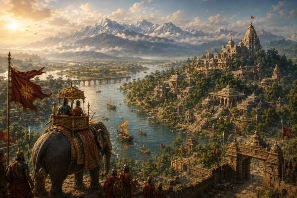
Modern Identification: Assam, with historical extensions into North Bengal, northern Bangladesh and the Bhutan foothills — India, Bangladesh and Bhutan
Kamarupa in the Ancient Geography of Eastern India
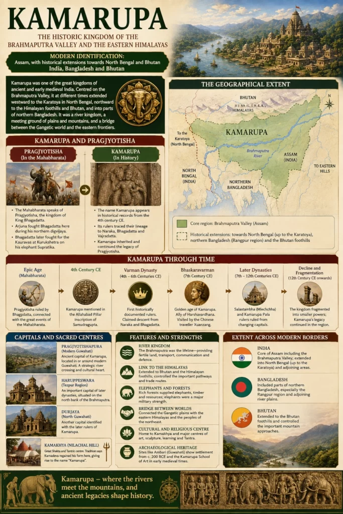
Kamarupa was one of the great historical kingdoms of northeastern India, centred on the Brahmaputra Valley of Assam but at different periods extending far beyond the boundaries of the modern state. At its widest remembered extent, its political and cultural sphere reached westward towards the Karatoya River and North Bengal, northward towards the Himalayan foothills and Bhutan, and into areas that today lie in northern Bangladesh. Its strategic position gave it command over the Brahmaputra corridor and the approaches connecting the Gangetic plains with the eastern Himalayas and the wider northeastern world. Government and historical sources describe ancient Kamarupa as considerably larger than modern Kamrup district, encompassing Assam as well as portions of North and East Bengal and Bhutan.
Kamarupa occupies a particularly interesting position when examining the geography of the Mahabharata. The epic repeatedly refers to Pragjyotisha, the kingdom of Bhagadatta, but does not clearly use Kamarupa as the name of that kingdom. The historical name Kamarupa emerges securely several centuries later. Over time, however, the rulers of Kamarupa deliberately connected themselves with the older traditions of Pragjyotisha, Naraka and Bhagadatta, creating a powerful continuity between epic geography and historical Assam.
Kamarupa and Pragjyotisha — An Important Distinction
Kamarupa and Pragjyotisha are often treated as interchangeable names, but their relationship is more complex.
Pragjyotisha is the name that belongs directly to the world of the Mahabharata. Bhagadatta is repeatedly identified with Pragjyotisha, and Arjuna travels there during his northern digvijaya before Yudhishthira’s Rajasuya. Bhagadatta later fights for the Kauravas at Kurukshetra, mounted on his famous elephant Supratika.
Kamarupa, by contrast, appears securely as a political name in historical inscriptions from around the fourth century CE. Banglapedia notes that the Mahabharata mentions Pragjyotisha but not Kamarupa and identifies the Allahabad Pillar inscription of Samudragupta as one of the earliest firm historical references to Kamarupa as a northeastern frontier kingdom.
The connection between the two became especially strong under the historical kings of Assam. Kamarupa’s ruling dynasties traced their ancestry to Naraka and Bhagadatta, thereby linking their historical kingdom with the prestigious epic kingdom of Pragjyotisha. By the time of Bhaskaravarman in the seventh century, this association had become an important part of royal political identity.
Kamarupa can therefore be understood as the historical kingdom that inherited and developed the geographical and dynastic memory of Pragjyotisha.
The Brahmaputra Valley as the Heart of Kamarupa
The enduring geographical centre of Kamarupa was the Brahmaputra Valley.
The Brahmaputra cuts a vast east-west corridor across Assam between the Himalayan foothills in the north and the hill systems of Meghalaya, Nagaland and neighbouring regions to the south and east. Its enormous floodplain provides fertile agricultural land while its tributaries create natural routes into surrounding valleys and mountain regions.
Control of this river corridor gave Kamarupa several advantages. Agricultural production could support substantial settlements, rivers could transport people and goods over long distances, forests supplied timber and elephants, and mountain routes opened connections towards Bhutan and the eastern Himalayas.
The Brahmaputra also acted as the principal geographical thread binding together a territory that could otherwise be difficult to administer because of forests, rivers, seasonal flooding and surrounding mountainous terrain.
Kamarupa was therefore fundamentally a river kingdom.
The Western Frontier at the Karatoya
The western extent of Kamarupa is one of the most important clues to understanding how much larger the historical kingdom could become than modern Assam.
Traditional descriptions place its western boundary near the Karatoya River, which flowed through the ancient geography of northern Bengal. Assam’s Kamrup district administration similarly records traditions describing Kamarupa as extending towards the Karatoya in the west.
This would bring parts of present-day North Bengal and northern Bangladesh within the wider historical geography associated with Kamarupa.
The region around modern Cooch Behar, Jalpaiguri and adjoining territories formed a natural transition between the lower Brahmaputra Valley and the northern Bengal plains. Farther south and west lay Pundravardhana and other major centres of ancient Bengal.
The Karatoya corridor consequently provided Kamarupa with access towards the Gangetic world.
Its western frontier was not permanently fixed. Political control expanded and contracted under different kings, and frontier areas could move between competing powers. Kamarupa should therefore not be represented as possessing a single immutable border throughout its history.
Nevertheless, the repeated association with the Karatoya demonstrates that its historical ambitions extended substantially beyond the present Assam-West Bengal boundary.
Kamarupa and Northern Bangladesh
Parts of what are now northern Bangladesh, particularly the wider historical Rangpur region, also fell within or interacted closely with Kamarupa during periods of its expansion.
Banglapedia describes Kamarupa as potentially encompassing the Brahmaputra Valley, Bhutan, Rangpur and Cooch Behar, together with adjoining territories.
This makes geographical sense because modern international borders did not exist in the ancient and early medieval period. The river plains of western Assam, North Bengal and northern Bangladesh belonged to a connected ecological and political zone.
The Brahmaputra itself historically followed different channels across this region, while tributaries and overland routes connected the lower Assam plains with northern Bengal.
Kamarupa’s presence in the region should therefore be understood through the shifting political geography of the Brahmaputra-Karatoya world rather than through present-day national boundaries.
The Bhutan Foothills and the Northern Frontier
To the north of the Brahmaputra Valley rise the foothills of the eastern Himalayas and the territories leading into modern Bhutan.
Kamarupa’s historical sphere repeatedly extended towards these mountain approaches. Standard historical accounts describe ancient Kamarupa as including portions of Bhutan, while Assam government material preserves traditions of a kingdom extending towards the Nepal-Bhutan frontier.
These northern connections were strategically and economically important.
Mountain communities could supply forest products, animals and commodities unavailable in the plains. Routes through the foothills connected the Brahmaputra Valley with Himalayan trading networks, while control of the duars—the gateways between the plains and the mountains—would become important repeatedly throughout the later history of Assam and Bhutan.
The northern frontier also reinforces one of the most distinctive characteristics already visible in the Mahabharata’s portrayal of Pragjyotisha: northeastern kingdoms existed at a meeting point between riverine plains and mountain peoples.
Pragjyotishapura — The Ancient Capital Tradition
The capital most strongly associated with early Kamarupa was Pragjyotishapura, generally located in or around modern Guwahati.
The historical significance of this name is considerable. By retaining Pragjyotishapura as the royal capital, historical rulers linked themselves directly to the older epic tradition of Pragjyotisha.
Ancient Guwahati possessed obvious strategic advantages. The Brahmaputra narrows between hills at several points around the city, creating naturally defensible passages and commanding river crossings. Routes towards the Khasi hills, western Assam, the upper Brahmaputra and the northern foothills converge in this region.
The Government of Assam notes the close historical relationship between Kamarupa and Pragjyotishpur and records the longstanding view that Pragjyotishpur functioned as Kamarupa’s capital.
The city consequently formed an important bridge between the epic memory of Bhagadatta’s Pragjyotisha and the documented kingdom of historical Kamarupa.
Kamarupa Emerges in the Historical Record
Unlike Pragjyotisha, which belongs primarily to epic and legendary geography, Kamarupa enters the securely datable political record during the Gupta period.
Samudragupta’s fourth-century Allahabad Pillar inscription includes Kamarupa among the frontier kingdoms associated with the northeastern edge of his political world. This marks an important transition: northeastern India was no longer merely represented through epic traditions but appears as an identifiable kingdom within the political geography of early historic India.
Around this period, the Varman dynasty emerged as the first historically well-documented royal house of Kamarupa.
The kingdom subsequently passed through several dynastic phases, traditionally divided between the Varmans, the Salastambha or Mlechchha rulers and the Kamarupa Palas.
Despite dynastic changes and shifts in capitals, the idea of Kamarupa as a major Brahmaputra kingdom endured for centuries.
The Varman Dynasty and the Naraka-Bhagadatta Lineage
The Varman rulers strengthened their legitimacy by linking themselves with the legendary rulers of Pragjyotisha.
Royal genealogical traditions traced their ancestry through Naraka, Bhagadatta and Vajradatta, characters already embedded in the epic traditions of northeastern India.
The historical accuracy of such extremely long genealogies cannot be treated literally. Their importance lies in what they reveal about royal identity.
For a king ruling the Brahmaputra Valley, claiming descent from Bhagadatta connected his kingdom with one of the most famous northeastern rulers in the Mahabharata. Bhagadatta had fought Arjuna, attended Yudhishthira’s Rajasuya and commanded one of the most devastating elephant forces at Kurukshetra.
The historical rulers of Kamarupa were therefore presenting themselves not as founders of an entirely new political order but as successors to an ancient royal tradition extending back into the epic age.
Bhaskaravarman and the Golden Age of Kamarupa
One of the greatest historical rulers of Kamarupa was Bhaskaravarman, who ruled during the first half of the seventh century.
His reign brought Kamarupa into the centre of North Indian politics.
Bhaskaravarman developed a close political relationship with Harshavardhana of Kannauj, one of the most powerful rulers of northern India. Their alliance demonstrated how deeply Kamarupa had become integrated into the diplomatic world stretching from the Brahmaputra to the Ganga plains.
During Bhaskaravarman’s reign, the Chinese Buddhist pilgrim Xuanzang—also known as Hiuen Tsang—visited Kamarupa. His journey provides one of the most valuable external accounts of the kingdom.
Assam government historical material records Xuanzang’s visit and identifies Bhaskaravarman as one of the major historically documented kings of Kamarupa.
Bhaskaravarman’s prominence also strengthened the association between historical Kamarupa and ancient Pragjyotisha. His dynasty presented its ancestry through the legendary line of Naraka and Bhagadatta, firmly embedding epic memory within the political ideology of early medieval Assam.
Capitals Beyond Pragjyotishapura
Although Pragjyotishapura remained the most famous capital associated with Kamarupa, political centres changed as different dynasties came to power.
Later rulers established capitals at locations identified with Haruppeswara, generally associated with the Tezpur region, and Durjaya, connected with North Guwahati.
These shifts demonstrate how political power moved along the Brahmaputra while remaining centred within the same broader river valley.
The kingdom was therefore not dependent upon a single city. Its strength came from control over an interconnected network of settlements, agricultural areas, river crossings and strategic corridors.
Guwahati, North Guwahati and Tezpur all occupied positions where rivers, hills and routes converged.
Kamakhya and the Sacred Geography of Kamarupa
No account of Kamarupa is complete without the Kamakhya tradition.
Nilachal Hill at Guwahati became one of the most important centres of Shakta worship in India, and Kamakhya became deeply connected with the cultural identity of Kamarupa.
Later traditions explain the name Kamarupa through the story of Kamadeva, the god of love. According to this tradition, Shiva had reduced Kama to ashes after Kama disturbed his meditation. Kama later regained his rupa, or form, in this region, producing the name Kama-rupa.
The Government of Assam preserves this traditional explanation while appropriately noting that the precise etymology remains a matter for scholars.
The story belongs to a later layer of sacred geography and should not be confused with the political geography of the Mahabharata. Its importance lies in demonstrating how the Brahmaputra Valley accumulated additional religious meanings over the centuries.
Kamarupa eventually became strongly associated with Tantric and Shakta traditions, with Kamakhya emerging as one of their greatest centres.
Archaeology and Ancient Guwahati
Archaeological discoveries provide important evidence for the antiquity and cultural importance of the Guwahati region.
At Ambari in Guwahati, excavations have uncovered substantial settlement remains, including brick structures, pathways, drainage systems, sculptures, terracotta objects, beads and other antiquities. Assam’s Directorate of Archaeology identifies Ambari as an important cultural centre of ancient Kamarupa and notes that the site’s early occupation extends back to approximately 200 BCE.
During the early medieval period, Ambari developed into an important centre for sculptors and artists. The artistic tradition discovered there is sometimes described as part of the distinctive Kamarupa School of Art.
These findings do not prove particular episodes of epic tradition. They do, however, demonstrate that the Guwahati region contained significant settlements long before and during the historical development of Kamarupa.
The archaeological evidence therefore complements the geographical importance suggested by literary and inscriptional sources.
The Four Traditional Divisions of Kamarupa
Later traditional geography divided the wider kingdom into four major regions or pithas.
These are generally remembered as Ratnapitha, Kamapitha, Suvarnapitha and Saumarpitha.
Assam government historical material preserves the tradition of four major subdivisions within the larger kingdom.
Such divisions reflect an attempt to organise an exceptionally large territory extending across different ecological zones.
Western Kamarupa approached the Bengal plains, central regions centred on the lower and middle Brahmaputra, while eastern portions extended further into the Assam Valley.
The fourfold division also survived strongly in later cultural geography even after the political unity of Kamarupa had disappeared.
Elephants, Forests and the Military Geography of the Northeast
The landscape of Kamarupa naturally favoured one of the military traditions most famously associated with the region—elephant warfare.
The connection reaches back to the Mahabharata’s Pragjyotisha. Bhagadatta is one of the epic’s greatest elephant warriors, while Supratika becomes one of the most formidable animals seen at Kurukshetra.
The Brahmaputra Valley and surrounding forests historically formed major habitats for Asian elephants. Control over such landscapes allowed northeastern rulers to obtain, train and deploy animals that represented enormous military and political value.
Although Bhagadatta belongs properly to Pragjyotisha rather than securely documented historical Kamarupa, later Kamarupa kings claimed precisely this royal heritage.
The elephant tradition therefore provided another symbolic link between the historical kingdom and the epic northeast.
A Meeting Ground of Plains and Mountain Cultures
Kamarupa occupied one of South Asia’s great geographical transition zones.
To the west lay the plains of Bengal and ultimately the Gangetic heartland. To the north were Bhutan and the eastern Himalayas. To the east lay the upper Brahmaputra and routes towards the eastern mountains. To the south rose the Meghalaya plateau and other hill regions.
This position brought Kamarupa into contact with communities speaking Indo-Aryan, Tibeto-Burman and other languages and practising a wide variety of religious and cultural traditions.
Historical Kamarupa consequently developed not simply as an eastern extension of Gangetic culture but as a distinctive civilisation formed through interaction between the Brahmaputra plains and the surrounding northeastern peoples.
The diverse populations surrounding Bhagadatta in the epic tradition—Kiratas, Chinas and mountain warriors—anticipate this broader geographical reality, even though the ethnic terminology of the Mahabharata cannot be mechanically equated with modern communities.
River Routes and Trade
The Brahmaputra served Kamarupa as both an artery and a defensive barrier.
Large rivers could make military invasion difficult, particularly during the monsoon, but they could also provide efficient transport. Boats could carry agricultural produce, timber, elephants, soldiers and trade goods across distances that would have been considerably harder to cover overland.
Western routes connected Kamarupa with Bengal and ultimately the Ganga Valley. Northern routes led towards Bhutan and Himalayan markets, while eastern passages linked the kingdom with the upper Brahmaputra and the wider northeastern frontier.
Kamarupa therefore occupied an intermediary position between several economic worlds.
Its strategic importance came not from coastal maritime trade like Tamralipta but from command of the great inland river corridor of northeastern India.
The Decline of Unified Kamarupa
Kamarupa did not remain politically unified indefinitely.
After centuries of rule under successive dynasties, central authority weakened and the old kingdom gradually fragmented. By approximately the twelfth century, new political formations were emerging across western and eastern Assam and North Bengal.
The name, however, survived.
Later kingdoms continued to invoke Kamarupa’s political inheritance, while the term Kamrup remained attached to western Assam and eventually became the name of a modern administrative district.
This survival illustrates the difference between a political kingdom and a geographical memory. The dynasty could disappear, capitals could shift and borders could change, yet the identity of Kamarupa remained embedded in the cultural landscape of the Brahmaputra Valley.
From Kamarupa to Kamata and Later Assam
The fragmentation of Kamarupa helped create the political landscape from which later regional powers emerged.
In western Assam and North Bengal, Kamata became an important successor polity. Farther east, other kingdoms developed in the Brahmaputra Valley. The arrival and expansion of the Ahoms from the thirteenth century would eventually transform the political identity of the region and give rise to the name by which Assam became widely known.
Yet Kamarupa remained an important historical reference point.
Later rulers understood that controlling the Brahmaputra Valley meant inheriting a political geography with roots extending back many centuries.
The old association with Pragjyotisha, Naraka, Bhagadatta and Kamakhya continued to give the region a sense of exceptional antiquity.
Kamarupa in the Mahabharata Landscape
Strictly speaking, Kamarupa should not be presented as a kingdom explicitly named in the Mahabharata in the same way as Pragjyotisha. The epic kingdom associated with Bhagadatta is Pragjyotisha. Historical evidence for Kamarupa as a political name emerges later, beginning securely around the fourth century CE. Banglapedia explicitly makes this distinction.
Yet separating the two completely would also obscure an important historical development.
The rulers of Kamarupa deliberately adopted the political memory of Pragjyotisha. They traced their ancestry to Naraka and Bhagadatta, retained Pragjyotishapura as an important royal centre, and embedded the epic traditions of the Brahmaputra Valley within their own dynastic identity. Historical scholarship consequently often speaks of a Pragjyotisha-Kamarupa tradition.
For the wider geography associated with the Mahabharata, Kamarupa therefore represents the historical continuation of the northeastern landscape remembered in the epic as Pragjyotisha.
Its core remained the Brahmaputra Valley of Assam, but its power could stretch west towards North Bengal and northern Bangladesh and north towards the Bhutan foothills. From the strategic river corridor around Guwahati emerged a kingdom that became one of early medieval India’s major eastern powers.
Kamarupa thus stands at the meeting point of epic memory and documented history—the great Brahmaputra kingdom that transformed the ancient legacy of Pragjyotisha into one of the most enduring political and cultural identities of northeastern India.
You may also like
-
Bharat Vandana Park: Delhi’s ‘Mini India’ Brings the Nation’s Heritage Together in One Landscape
-
Pragjyotisha — Bhagadatta’s Kingdom of the Brahmaputra Valley
-
Samatata — The Low-Lying Deltaic Realm of Southeastern Bengal
-
Tamralipta — The Maritime Gateway of the Lower Ganga
-
Suhma — The River-and-Forest Country of Southwestern Bengal
