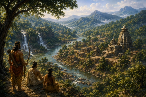
Vanavasi, also written Vanavasa, Vanavasaka or Vanavasika, was an ancient country of southern Bharat associated with the forested Western Ghats of present-day Karnataka. Its geographical centre is generally connected with Banavasi, the ancient settlement near Sirsi in today’s Uttara Kannada district. The Mahabharata recognises the Vanavasis as one of the peoples of southern India and refers to them both during Sahadeva’s southern conquest and in the great geographical catalogue of Bharatavarsha.
The identification is particularly significant because Banavasi remained an important political and cultural centre long after the period represented by the Mahabharata. It subsequently appears in Buddhist traditions, inscriptions and classical geographical accounts before becoming the celebrated capital of the Kadamba dynasty. Archaeological and epigraphic evidence therefore demonstrates the antiquity of Banavasi as a major settlement, although the later historical city and kingdom should not automatically be projected unchanged into the epic age. Modern Karnataka Tourism describes Banavasi as one of Karnataka’s oldest towns and the historic capital of the Kadambas.
Vanavasi at a Glance
| Feature | Identification |
|---|---|
| Ancient Name | Vanavasi / Vanavasa / Vanavasika |
| Political Character | Southern janapada or regional kingdom |
| Mahabharata Location | Southern Bharat |
| Approximate Modern Region | Western and north-western Karnataka |
| Principal Ancient Centre | Banavasi |
| Modern Location of Banavasi | Uttara Kannada district, Karnataka |
| Nearby Modern Centre | Sirsi |
| Major Geographical Feature | Western Ghats |
| Important River | Varada River |
| Mahabharata Connection | Conquered or brought under tribute during Sahadeva’s southern campaign |
| Geographical Catalogue | Listed among southern peoples in the Bhishma Parva |
| Wider Region | Dakshinapatha |
| Later Historical Importance | Capital of the Kadamba dynasty |
| Other Ancient Name of Banavasi | Vaijayanti / Vaijayantipura |
| Modern State | Karnataka |
| Country Today | India |
Where Was Ancient Vanavasi?
Ancient Vanavasi is generally associated with the country surrounding Banavasi in Uttara Kannada district of Karnataka, east of the coastal belt and within the forested approaches of the Western Ghats. Banavasi lies near the Varada River and approximately south-east of Sirsi, surrounded by an environment of rivers, forests and fertile valleys that fits well with the ancient regional name.
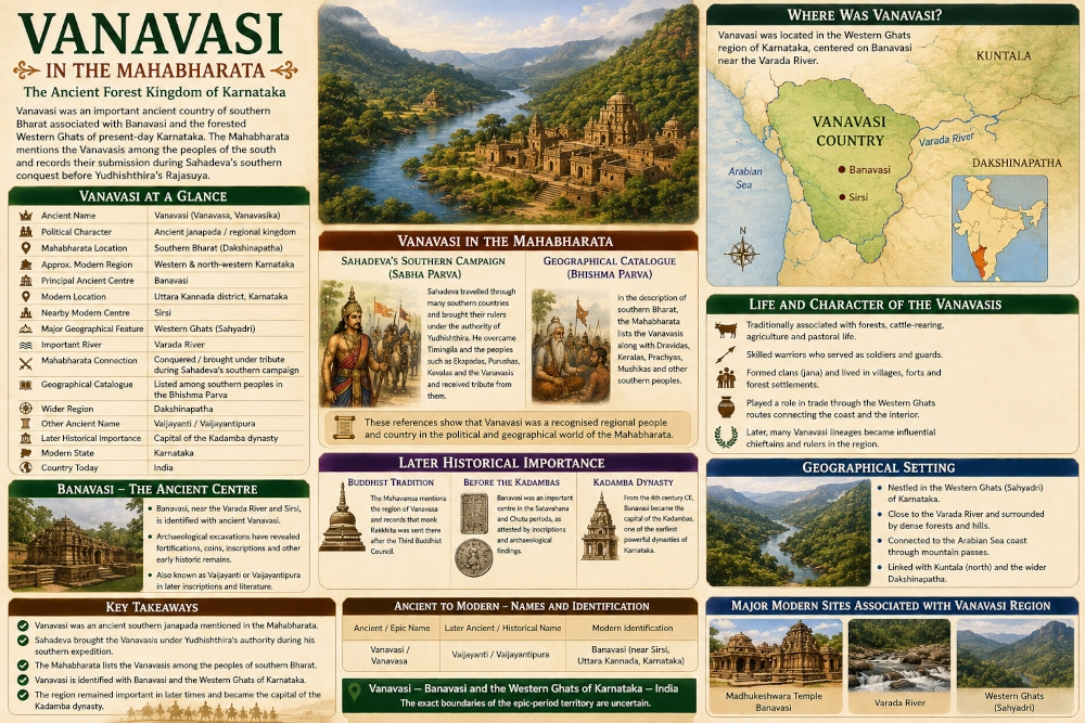
Archaeological scholarship notes that Banavasi appears under forms such as Vanavasa, Vanavasaka and Vanavasi in inscriptions, literary traditions and accounts of travellers. Another major ancient name was Vaijayanti or Vaijayantipura. Archaeological work at Banavasi has revealed substantial early historic occupation, including fortifications, coins, inscriptions and other material remains.
The Mahabharata itself does not give the modern boundaries of Vanavasi. Consequently, it is safer to identify it with a broad Western Ghats and adjoining interior Karnataka region centred upon Banavasi rather than drawing a rigid boundary around modern Uttara Kannada.
Vanavasi in the Mahabharata
Vanavasi appears clearly in the Mahabharata’s political geography. One of the most significant references occurs during Sahadeva’s digvijaya, or conquest of the southern direction, undertaken before Yudhishthira’s Rajasuya sacrifice.
The Sabha Parva describes Sahadeva travelling through a succession of southern countries and compelling rulers and peoples to acknowledge Yudhishthira’s sovereignty. Among the communities brought under his authority were the Vanavasis. The passage places them within a sequence of southern peoples and regions encountered as the Pandava prince advanced through the Dakshinapatha.
Vanavasi appears again in the Bhishma Parva, where the Mahabharata provides an extensive catalogue of the lands and peoples of Bharatavarsha. The Vanavasis are specifically listed among the southern peoples alongside groups such as the Dravidas, Keralas, Mushikas and Mahishakas. This is particularly valuable because it confirms that Vanavasi was understood as a distinct geographical community within southern Bharat.
Sahadeva’s Southern Campaign
Before Yudhishthira could perform the Rajasuya, the four younger Pandava brothers undertook military expeditions in the four directions. Sahadeva was assigned the south, giving the Sabha Parva one of its most valuable sequences for reconstructing the political geography of the Deccan and southern India.
Sahadeva moved through numerous countries, defeating some rulers in battle while receiving submission and tribute from others. The text describes him bringing King Timingila under control before overcoming peoples including the Ekapadas, Purushas, Kevalas and Vanavasis. He subsequently secured tribute from Sanjayanti, the Pashandas and Karahatakas.
This sequence is important because it places Vanavasi within an identifiable southern geographical network. Karahatakas are usually associated with the Karad region of Maharashtra, while other places mentioned during Sahadeva’s campaign stretch across the western Deccan and farther south. Vanavasi therefore belongs naturally within the Karnataka portion of the campaign.
The episode also demonstrates that the region was politically significant enough to be separately named during the expansion of Pandava imperial authority before the Rajasuya.
Vanavasi in the Geography of Bharatavarsha
The Bhishma Parva’s geographical description provides another independent reference. While describing the countries lying in southern Bharat, the Mahabharata lists the Dravidas, Keralas, Prachyas, Mushikas and Vanavasis, followed by several additional southern peoples.
This passage is especially useful because it makes the southern orientation of Vanavasi explicit. It also positions Vanavasi among established regional names rather than treating the word merely as a description of people dwelling in forests.
The distinction matters because the Sanskrit word vanavasa can ordinarily mean residence in a forest, particularly in the context of exile. The Pandavas themselves famously underwent a period of vanavasa. In the geographical passages concerning the Vanavasis, however, the term functions as the name of a regional people. The surrounding country names and later evidence concerning Banavasi support this interpretation.
Vanavasi and Banavasi
Modern Banavasi provides the strongest geographical anchor for ancient Vanavasi. The settlement is located in present-day Uttara Kannada district, close to the Varada River and the densely forested Western Ghats.
Banavasi is recognised as one of the oldest historic towns of Karnataka. Its later fame came particularly from the Kadambas, who established their capital there during the fourth century CE. The Kadambas became one of the earliest important dynasties based within Karnataka and helped make Banavasi a major political and cultural centre.
The historical importance of Banavasi should not be used to claim that the Kadamba kingdom existed during the Mahabharata. The dynastic period belongs to a much later and historically documented age. What it does demonstrate is that the region identified in ancient literature continued to support an important urban and political centre for centuries.
The Meaning of the Name
The name Vanavasi naturally evokes the heavily forested environment of the Western Ghats. In Sanskrit, vana means forest, while vasa or related forms convey habitation or residence. Later traditions therefore understood Vanavasi as a country characterised by forest settlement.
This geographical interpretation makes considerable sense. The Western Ghats around Uttara Kannada contain some of the most densely wooded landscapes of peninsular India. Rivers descending through the mountains, fertile interior valleys and routes crossing between the coast and the plateau created a landscape in which forest and settlement existed side by side.
Traditional Kannada sources also preserve the connection between Banavasi and the older form Vanavasa. The region’s forests became such a defining feature that the geographical name itself remained associated with them.
The Western Ghats and the Vanavasi Landscape
The Western Ghats, known traditionally as the Sahyadri, form the dominant physical feature of the Vanavasi region. These mountains run parallel to India’s western coast and create a dramatic division between the humid Konkan and Kanara coastal belt and the elevated Deccan plateau.
Around Banavasi, however, the mountains are broken by valleys, rivers and passes that allowed communication between the interior and the Arabian Sea coast. Vanavasi therefore occupied an important transitional zone. It was neither purely coastal nor entirely an inland plateau country.
Its forests provided timber, medicinal plants, animals and other resources, while river valleys supported agricultural settlements. Mountain routes linked the region with neighbouring Kuntala, the western coast and territories farther north towards the upper Krishna basin.
These geographical conditions help explain how Vanavasi could emerge as a distinct ancient janapada despite its heavily wooded environment.
The Varada River
The Varada River is one of the most important geographical features around Banavasi. The ancient settlement developed close to this river, which eventually becomes part of the wider Tungabhadra-Krishna river system.
Archaeological descriptions of Banavasi specifically note its position near the Varada. The river valley would have provided water, fertile agricultural land and a convenient natural route through a region otherwise dominated by forests and uplands.
For the map, the Varada should therefore be prominently marked beside Banavasi. Showing the river helps readers understand why an important political centre could develop within a landscape popularly associated with forests.
Vanavasi and Kuntala
One of the most important neighbouring ancient regions was Kuntala, which broadly covered parts of southern Maharashtra and northern Karnataka. Ancient geographical boundaries were fluid, and later political terminology sometimes allowed the names Kuntala and Vanavasi to overlap or be used within wider regional descriptions.
For the Mahabharata geography map, however, they should remain separate because the epic treats Kuntala and Vanavasi as recognisable regional names. Kuntala can be shown farther north and north-east, while Vanavasi should occupy the Western Ghats and adjoining interior around Banavasi.
The relationship between these regions demonstrates the complexity of ancient Karnataka’s geography. The modern state contained several cultural and political zones rather than one unified kingdom corresponding exactly to present-day Karnataka.
Vanavasi and the Western Coast
To the west of Vanavasi lay the Arabian Sea coastal belt, including parts of what later became known as the Konkan and Kanara regions. The mountains separating Vanavasi from the coast were formidable, but they were crossed by established paths and passes.
This geographical position gave the region access to maritime networks without making Vanavasi itself primarily a coastal country. Goods arriving through ports on the western coast could travel inland through the Ghats, while agricultural and forest products from the plateau could move towards the sea.
Later historical evidence shows strong political connections between rulers based at Banavasi and territories extending towards the Konkan. These later relationships illustrate the natural geographical links created by the mountain passes, even though they should not automatically be projected into the Mahabharata period.
Vanavasi and Dakshinapatha
Vanavasi formed part of the larger geographical world known as Dakshinapatha. The term could refer broadly to the southern country, but it also carried the sense of the great routes connecting central and northern India with the Deccan and farther south.
The Mahabharata’s placement of the Vanavasis among southern peoples agrees with this wider context. The region stood near routes that connected the upper Krishna basin and western Deccan with deeper Karnataka and the western coast.
Vanavasi therefore occupied an advantageous position within ancient southern geography. Travellers could approach it from the north through the Deccan plateau, from the east through Karnataka’s river valleys, or from the west through passes descending towards the Arabian Sea.
Vanavasi and the Rajasuya
Sahadeva’s conquest of the Vanavasis formed part of the political preparations for Yudhishthira’s Rajasuya sacrifice. The ceremony required Yudhishthira’s authority to be recognised across a wide network of kingdoms, either through alliance, submission or tribute.
By mentioning the Vanavasis separately, the Sabha Parva shows that their country was considered a meaningful component of southern political geography. Sahadeva’s campaign was not simply an expedition against a few major monarchies. It incorporated numerous smaller kingdoms, peoples and regional powers into Yudhishthira’s imperial network.
Vanavasi’s inclusion consequently places the Western Ghats of Karnataka directly within the political horizon of Indraprastha.
Was Vanavasi a Kingdom or a People?
The Mahabharata’s terminology does not always allow a modern distinction between kingdom, tribe, people and territorial state. In some passages the inhabitants of a region are named rather than an individual monarch. The term Vanavasis literally refers to the people of Vanavasi.
It is therefore safer to describe Vanavasi as an ancient janapada or regional country rather than insist that it possessed one continuously unified monarchy throughout the entire epic tradition.
Sahadeva’s conquest indicates that the inhabitants were politically organised enough to be brought under tribute. The Bhishma Parva independently treats them as one of the recognised peoples of southern Bharat. Together, these passages establish Vanavasi as a genuine regional identity without requiring assumptions about its exact governmental structure.
From Vanavasi to Vaijayanti
In later historical sources, Banavasi also became known as Vaijayanti or Vaijayantipura. Inscriptions associated with the early historic Deccan and later Kadamba rulers preserve variants of these names. Archaeological scholarship notes that Vanavasa, Vanavasi and Vaijayanti were all associated with the settlement now known as Banavasi.
The appearance of several names should not cause confusion. Ancient Indian cities frequently possessed alternative Sanskrit, Prakrit, dynastic or regional names, while pronunciation and spelling changed across centuries.
For the Mahabharata geography series, Vanavasi should remain the principal regional label because that is the form relevant to the epic. Banavasi should be used as the modern geographical identification, while Vaijayanti can be mentioned as an important later ancient name of the city.
The Buddhist Tradition of Vanavasa
Vanavasi continued to appear in Indian literature long after the epic traditions. The Mahavamsa, a major Buddhist chronicle, records that following the Third Buddhist Council, missionaries were sent to several regions and that the monk Rakkhita was dispatched to Vanavasa.
The same textual tradition later speaks of monks arriving from the Vanavasa country for important Buddhist ceremonies. These accounts show that the name Vanavasa continued to identify a recognised southern region during the early historic period.
Although these Buddhist episodes belong to a later period than the Mahabharata setting, they provide useful independent evidence for the longevity of the geographical name.
Banavasi Before the Kadambas
Banavasi was already an important settlement before the rise of the Kadambas. Archaeological and inscriptional evidence connects the city with earlier political formations of the Deccan, including the Satavahana and Chutu periods.
An inscription from the Banavasi region records rulers associated with the Chutu lineage, while archaeological material demonstrates significant occupation during the early centuries CE.
These discoveries are important because they demonstrate that Banavasi did not suddenly emerge when the Kadambas selected it as their capital. The town had already possessed political, religious and economic importance.
The Mahabharata reference to the Vanavasis therefore fits within a much longer tradition in which this part of Karnataka maintained a distinct regional identity.
The Kadambas of Banavasi
The later history of Banavasi became inseparable from the Kadamba dynasty. Founded by Mayurasharma in approximately the fourth century CE, the Kadambas ruled from Banavasi and became one of the most important early dynasties native to Karnataka.
Banavasi consequently developed into a celebrated centre of government, religion and Kannada culture. Karnataka Tourism describes it as Karnataka’s historic first capital and emphasises the city’s continuing association with Kadamba heritage.
This later history should be presented as the continuation of Vanavasi’s geographical importance rather than part of the Mahabharata narrative itself. The epic and the Kadamba inscriptions belong to very different textual and historical contexts.
Their connection lies in the remarkable survival of the place-name and settlement.
The Cultural Memory of Banavasi
Banavasi acquired a special place in Kannada cultural memory. The great Kannada poet Pampa famously celebrated the beauty of the Banavasi country and expressed a profound attachment to its landscape.
Later literature continued to associate Banavasi with forests, temples and the distinctive beauty of the Malnad region. The town’s surviving cultural landscape reflects layers of Shaiva, Jain and Buddhist history accumulated over many centuries.
This literary reputation is particularly fitting for a region whose ancient name was so closely associated with the forest. The green hills and river valleys surrounding modern Banavasi preserve much of the geographical character that gave the ancient country its identity.
The Madhukeshwara Tradition
Modern Banavasi is especially famous for the Madhukeshwara Temple, dedicated to Shiva. The existing architectural complex reflects developments belonging to historical periods much later than the Mahabharata, and it should therefore not be presented as an epic-period monument.
Nevertheless, the temple became one of the principal sacred landmarks of Banavasi and illustrates the town’s continuing religious importance. Karnataka Tourism identifies the Madhukeshwara Temple as one of the central monuments of the ancient town and an enduring focus of its cultural identity.
Traditional legends surrounding Banavasi connect the landscape with much older mythological narratives, but these traditions must be distinguished from direct statements in the Mahabharata.
Did the Pandavas Live at Banavasi?
Local traditions sometimes claim that the Pandavas spent part of their exile around Banavasi. Such traditions are common at ancient sacred places throughout India and form an important part of regional cultural memory.
However, the stronger textual connection between Vanavasi and the Mahabharata comes from Sahadeva’s southern campaign and the Bhishma Parva geographical catalogue, not from a securely identifiable episode stating that the five Pandavas lived at modern Banavasi during their exile.
The distinction is important. The Sanskrit word vanavasa also means forest exile, which can easily encourage later associations between places called Vanavasi and the Pandavas’ twelve years in the forest.
Ancient Vanavasi and Modern Geography
| Ancient Reference | Approximate Modern Association |
|---|---|
| Vanavasi / Vanavasa | Western and north-western Karnataka |
| Principal Centre | Banavasi |
| Banavasi | Sirsi region, Uttara Kannada district |
| Major Landscape | Western Ghats / Sahyadri |
| River | Varada River |
| Vaijayanti / Vaijayantipura | Later ancient name associated with Banavasi |
| Kuntala | Neighbouring region of northern Karnataka and southern Maharashtra |
| Western Coastal Country | Kanara-Konkan belt towards the Arabian Sea |
| Wider Ancient Region | Dakshinapatha |
| Modern State | Karnataka |
| Country Today | India |
These associations should be treated as approximate. Banavasi itself is securely located, but the outer boundaries of the Mahabharata’s Vanavasi country cannot be reconstructed with the precision of a modern district or state.
Vanavasi’s Place in the Mahabharata World
Vanavasi provides an important geographical link between the Mahabharata and the western Deccan. Its appearance during Sahadeva’s southern expedition demonstrates that the political world surrounding Yudhishthira extended deep into Karnataka, while the Bhishma Parva confirms that the Vanavasis were recognised among the distinct peoples of southern Bharat.
The region also illustrates the importance of landscape in ancient Indian political geography. Vanavasi developed in a heavily forested mountain environment quite different from the open plains of the Ganga valley or the drier plateau regions farther north. Its rivers, forests and mountain passes shaped a distinctive regional identity.
At the same time, Vanavasi was not isolated. Routes through the Western Ghats connected it with the coast, while inland roads linked it with Kuntala and the wider Dakshinapatha. Its later rise as a major political capital demonstrates how strategically important this location could become.
The Legacy of Vanavasi
Vanavasi is one of those Mahabharata geographical names whose later history greatly strengthens our understanding of its location. The epic remembers the Vanavasis as a southern people, and Sahadeva encounters them during his conquest of the Dakshinapatha. Later Buddhist texts continue to recognise Vanavasa as an important region, while inscriptions and archaeology reveal Banavasi as a major early historic centre. Eventually, the city became the famous capital of the Kadambas.
The result is an unusually long geographical continuity. Although political boundaries shifted and dynasties disappeared, the Vanavasi-Banavasi identity remained attached to the same forested country of Karnataka.
Vanavasi — Banavasi and the Western Ghats of Karnataka — India.
The exact boundaries of ancient Vanavasi cannot be recovered, but its broad location is convincing. The Mahabharata places the Vanavasis among the peoples of southern Bharat; Sahadeva encountered them during his southern campaign; and later literary, archaeological and inscriptional evidence repeatedly returns us to the ancient settlement of Banavasi in the green Western Ghats of Karnataka.
Sources and Textual Basis
The principal Mahabharata evidence comes from the Sabha Parva, where the Vanavasis appear among the peoples subdued during Sahadeva’s southern digvijaya before Yudhishthira’s Rajasuya sacrifice. The Bhishma Parva independently names the Vanavasis among the southern janapadas of Bharatavarsha, alongside the Dravidas, Keralas and Mushikas.
The geographical association with modern Banavasi is strengthened by archaeological and epigraphic scholarship showing that the settlement was historically known by forms such as Vanavasa, Vanavasaka and Vanavasi, as well as Vaijayanti. Banavasi lies near the Varada River in present-day Uttara Kannada district and later became the capital of the Kadamba dynasty.
These sources together support the broad identification of Vanavasi with Banavasi and the Western Ghats of Karnataka, while the precise territorial boundaries should remain approximate.
You may also like
-
Kuntala in the Mahabharata: The Ancient Country of Northern Karnataka and Southern Maharashtra
-
Ashmaka or Assaka in the Mahabharata: The Ancient Kingdom of the Godavari Valley
-
Rare Stone Features Emerge as Kerala Archaeology Department Restores Megalithic Kudakkals at Karivellur
-
Vidarbha in the Mahabharata: The Ancient Kingdom of Damayanti in Eastern Maharashtra
-
Abhira in the Mahabharata: The Pastoral People of Western India and the Northern Deccan
