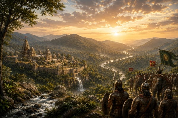
The Mahabharata remembers the Mekalas as a distinct people of ancient Bharat and repeatedly places their warriors among the regional contingents drawn into the Kurukshetra War. The name survives with remarkable geographical continuity in the Maikal Hills, the forested highlands around Amarkantak where the Narmada, Son and Johila rivers arise. Historical-geographical scholarship specifically connects Sanskrit Mekala with the later Maikal range.
Unlike kingdoms such as Magadha, Vatsa or Avanti, the Mahabharata does not provide Mekala with a clearly named royal capital in the passages that survive. Its identity is instead strongly geographical. Mekala appears as a hill country and as the homeland of the Mekala people, whose territory can be correlated principally with the Amarkantak-Maikal highlands of present-day Madhya Pradesh and adjoining central India.
The epic also gives the Mekalas a distinctive military character. They fought on the Kaurava side, guarded Bhishma during the early stages of the war, and later appeared among regional troops renowned for fighting from elephants. During the Karna Parva, Mekala warriors joined other eastern and central Indian contingents in a fierce assault against Nakula and the Pandava forces.
Mekala at a Glance
| Feature | Description |
|---|---|
| Ancient Region | Mekala / country of the Mekalas |
| Epic People | Mekalas |
| Probable Geographical Core | Amarkantak and the Maikal Hills |
| Modern Core | Anuppur region of eastern Madhya Pradesh and adjoining Maikal highlands |
| Principal Geographic Landmark | Amarkantak plateau |
| Major River Association | Narmada |
| Other Rivers Rising in the Region | Son and Johila |
| Epic Capital | No capital securely identified in the cited Mahabharata passages |
| Mahabharata Political Alignment | Kaurava side during the Kurukshetra War |
| Military Association | Noted among forces skilled in elephant warfare |
| Bhishma Association | Mekala troops helped guard Bhishma |
| Karna Association | Mekalas remembered among peoples earlier subdued by Karna |
| Modern State | Madhya Pradesh, with the wider Maikal zone extending toward adjoining Chhattisgarh |
| Country Today | India |
The modern identification is strengthened by the survival of the geographical name itself. Studies of ancient Indian geography note that Mekala is preserved in the modern name Maikal, the hill chain associated with Amarkantak and the eastern end of the central Indian highlands.
The Land of Mekala
Ancient Mekala should be visualised very differently from the great river-valley kingdoms of northern India. It was fundamentally a highland and forest region, centred upon the Maikal system around Amarkantak rather than upon a broad alluvial plain dominated by one major fortified city.
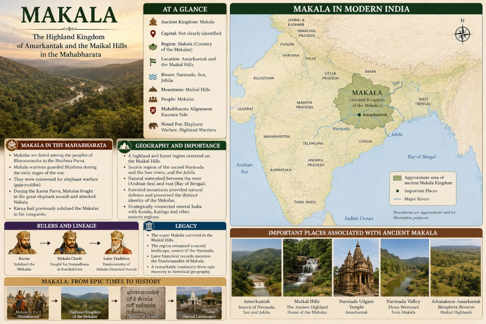
Amarkantak today lies in Anuppur district of Madhya Pradesh at roughly 1,067 metres above sea level. The district administration places it on the Maikal mountain range linking the Vindhya and Satpura systems. The Narmada and Son originate here, while the Johila also rises in the surrounding highlands.
For the purposes of reconstructing Mahabharata geography, the core Mekala landscape can therefore be represented approximately as:
Amarkantak → upper Narmada source region → Maikal Hills → adjoining forested highlands of eastern Madhya Pradesh
The ancient political boundary cannot be drawn like a modern district border. The Mahabharata identifies the people and country but does not supply surveyed frontiers. The safest reconstruction is therefore a shaded highland zone centred upon Amarkantak and the Maikal range, rather than a sharply outlined state. Historical-geographical scholarship likewise identifies Mekala with the Maikal country while allowing for a wider regional extent.
Amarkantak: The Geographical Heart of Mekala
Amarkantak provides the strongest modern anchor for locating ancient Mekala. It stands where the central Indian uplands form one of the subcontinent’s most important watersheds. Madhya Pradesh Tourism describes the region as the meeting zone of the Vindhya and Satpura systems, with the Maikal Hills forming its prominent highland feature.
Its importance comes above all from water. The Narmada flows westward from the Amarkantak region toward the Arabian Sea, while the Son belongs to the great eastward-draining Ganga system. The Johila also begins in these uplands. The Achanakmar-Amarkantak Biosphere Reserve consequently occupies a major watershed separating river systems flowing toward opposite sides of the Indian peninsula.
This landscape helps explain why Mekala retained such a strong geographical identity. Mountains, forests, river sources and difficult upland routes could preserve the distinctiveness of the people living there even when larger political powers dominated surrounding regions.
The Name Mekala Survives in the Maikal Hills
One of the strongest arguments for locating Mekala around Amarkantak is linguistic and geographical continuity.
Historical studies explicitly state that the modern Maikal range preserves the ancient name Mekala. The Maikal chain links the Vindhyan and Satpura systems near Amarkantak, precisely the region associated in Sanskrit geographical traditions with Mekala.
This makes Mekala particularly valuable in the reconstruction of Mahabharata geography. In many cases, an ancient janapada name disappeared completely or survives only through literary references. Here, however, the ancient geographical name appears to have endured in altered form across centuries.
Mekala → Maikal
The continuity does not prove that every part of the modern Maikal range belonged to one political state during the epic period. It does, however, provide a powerful geographical anchor for locating the Mekalas of the Mahabharata.
Mekala in the Mahabharata’s Geography of Bharata
The Bhishma Parva contains one of the Mahabharata’s great geographical catalogues of the peoples and countries of Bharatavarsha. Among the names recorded are the Chedis, Vatsas, Karushas, Bhojas, Dasharnas, Mekalas and Utkalas.
The sequence is useful because several of these peoples belong broadly to central and eastern India. Dasharna is associated with the Vidisha-eastern Malwa region, while Utkala lay farther east toward Odisha. Mekala fits naturally between the central Indian plateau and the eastern regions.
The Mahabharata therefore treats Mekala not simply as the name of a mountain. Mekalas are presented as a recognised people within the political and ethnogeographical landscape of Bharatavarsha.
The Mekalas Guard Bhishma
Mekala becomes much more than a name in a geographical catalogue once the Kurukshetra War begins.
During the deployment of the Kaurava army, the Bhishma Parva records the Vidarbhas and Mekalas among the forces associated with protecting Bhishma. The BORI text at 6.47.13 explicitly names the Mekalas alongside the Vidarbhas and Karnapravaranas in the forces surrounding the great Kuru commander.
This passage firmly places the Mekala contingent within the Kaurava military coalition during the early stages of the war.
Their presence near Bhishma also shows that Mekala was capable of contributing an organised regional contingent to the enormous coalition assembled by Duryodhana. The epic does not describe these warriors as isolated forest fighters. They form part of the structured battlefield formations of the Kuru host.
Mekala’s Warriors and the Elephant Corps
One of the most interesting details about Mekala appears in the Karna Parva.
Sanjaya describes warriors from Mekala, Kosala, Madra, Dasharna and Nishadha fighting alongside the Kalingas. The text specifically calls them skilled in elephant warfare — gaja-yuddha.
This is an important detail for reconstructing the military character associated with Mekala.
The forested highlands of central and eastern India formed part of a wider geographical belt where elephants played an important economic and military role in later historical periods. The Mahabharata’s description should not automatically be converted into a precise economic history of ancient Mekala, but it does show that the epic remembered Mekala warriors among contingents proficient in fighting with elephants.
Their battlefield role was therefore associated not merely with infantry or archery but with one of ancient India’s most formidable military arms.
The Great Elephant Assault on the Pandava Army
The Karna Parva gives the Mekalas one of their clearest appearances in the fighting.
At Duryodhana’s command, large numbers of elephant troops advanced against the Pandava-Panchala forces. Mekalas joined the Kosalas, Madras, Dasharnas, Nishadhas and Kalingas within this enormous elephant assault. The elephants surged forward while the warriors accompanying them showered the opposing ranks with arrows, javelins and other missiles.
The Pandava warriors responded with concentrated archery. Nakula, Sahadeva, Satyaki, Shikhandi, the sons of Draupadi and other fighters attacked the advancing elephants from different directions. The battle became a brutal struggle between mobile elephant formations and Pandava chariot warriors.
The episode places Mekala directly within one of the epic’s major combined-arms battlefield descriptions.
The Mekalas Attack Nakula
Even after the main elephant assault began to break apart, the Mekala contingent continued fighting.
The Karna Parva records that warriors from Mekala, Utkala, Kalinga, Nishadha and Tamralipta advanced against Nakula. They rained arrows and javelins upon him and sought to overwhelm the Pandava prince amid the fighting around the elephant corps.
Nakula became so heavily surrounded that the epic compares him to the sun covered by clouds. Pandava, Panchala and Somaka warriors then rushed forward to rescue him, producing another fierce clash between chariots and elephants.
This episode is especially useful because it establishes the Mekalas as active battlefield participants rather than merely one of the many peoples listed as present at Kurukshetra.
Their sequence in the war can therefore be reconstructed as:
Mekala joins the Kaurava coalition → Mekala troops help protect Bhishma → Mekala elephant warriors fight with other regional contingents → Mekalas later attack Nakula during the Karna Parva
Karna and the Earlier Conquest of Mekala
The Mahabharata also preserves a tradition that Karna had previously subdued the Mekalas.
In the Drona Parva, a passage recalling Karna’s military achievements lists the Mekalas among numerous peoples defeated by him, together with regions including the Paundras and Kalingas.
This provides a plausible political background for their later appearance in Duryodhana’s army. Karna had spent years extending Kuru influence and establishing Duryodhana’s prestige among neighbouring rulers. The reference to Mekala indicates that Kuru power had reached deep into central India before Kurukshetra.
The epic does not tell us enough to determine the exact political arrangement after this conquest. Mekala may have retained its own chiefs while accepting Kuru supremacy or obligations of military support. What is clear is that its warriors later appeared in the Kaurava host.
Mekala Between Central India and the Eastern Kingdoms
Mekala occupied a strategically interesting geographical position.
To its west and northwest lay the wider Narmada and central Indian world. Regions such as Dasharna, Chedi and the central Indian kingdoms formed part of this larger political landscape. To the east and southeast lay Kosala and the routes leading toward Kalinga and Utkala.
The Mahabharata’s battlefield lists repeatedly place the Mekalas alongside peoples such as Dasharnas, Utkalas, Kosalas and Kalingas. Although military lists do not constitute maps, the recurring associations broadly fit the expected position of the Maikal-Amarkantak country between central India and the eastern regions.
Mekala was therefore not an isolated mountain enclave. Its position connected the Narmada uplands with routes leading into ancient Kosala, eastern Madhya Pradesh, Chhattisgarh and ultimately the eastern coast.
Narmada and the Sacred Landscape of Mekala
The greatest geographical feature associated with the Mekala country is the Narmada.
The river rises at Amarkantak before beginning its long westward journey through central India. Government sources identify Amarkantak as the origin region of the Narmada as well as the Son and Johila.
Later Sanskrit traditions frequently connect the Narmada with Mekala, and historical-geographical scholarship recognises the river’s source region as central to identifying ancient Mekala. The relationship between mountain and river became so strong in literary memory that Narmada came to be associated with Mekala as the river of those hills.
This sacred geography substantially outlived any particular Mekala kingdom.
Dynasties disappeared. Political frontiers changed. Yet Amarkantak remained one of India’s great sacred landscapes, and the Narmada continued to carry the memory of the mountain country from which it emerged.
Forests, Highlands and Natural Defences
The physical environment would have strongly distinguished Mekala from kingdoms centred in the Gangetic plain.
The Amarkantak-Maikal zone contains high plateaus, steep slopes, forested valleys and numerous streams. The modern Achanakmar-Amarkantak Biosphere Reserve still preserves extensive parts of this central Indian highland ecosystem.
Such terrain naturally created different patterns of settlement and movement from those found along major plains such as the Ganga-Yamuna Doab. Any ancient state occupying these hills would have controlled passes, forest routes, river headwaters and connections between northern, central and eastern India.
This may also help explain why the Mahabharata more frequently remembers the Mekalas as a people rather than describing a famous urban capital comparable with Hastinapura, Indraprastha, Mathura, Ujjain or Girivraja.
From Epic Mekala to Historical Mekala
Mekala did not disappear with the Mahabharata tradition.
Centuries later, historical records refer to rulers known as the Panduvamshis of Mekala. Their territory was associated with the Maikal region, providing independent historical confirmation that Mekala continued to function as a recognised geographical and political name in central India.
The later dynasty should not be projected backward into the Mahabharata period. The two belong to very different chronological layers.
Nevertheless, the continued use of the name is significant.
The Mahabharata knows the Mekalas.
Later Sanskrit geography knows Mekala.
Historical dynasties ruled a country called Mekala.
Modern India still possesses the Maikal Hills.
The geographical continuity is unusually strong.
Mekala on the Modern Map
For the purpose of our Mahabharata kingdoms and ancient geolocation series, Mekala can be represented approximately as:
Mekala → Amarkantak plateau + Maikal Hills + upper Narmada source region → eastern Madhya Pradesh and adjoining central Indian highlands → India
The principal mapped core should remain:
Amarkantak – Pushprajgarh/Anuppur region – Maikal Hills – upper Narmada headwaters
A wider shaded zone may extend through adjoining Maikal hill country, but this should be presented as an approximate cultural-geographical region rather than as a precise Mahabharata political frontier. Scholarly reconstructions differ regarding the full historical extent of Mekala, while the Amarkantak-Maikal identification remains the strongest geographical anchor.
Modern Identification
| Ancient Geography | Modern Geographical Correlation |
|---|---|
| Mekala | Maikal hill country of central India |
| Principal Ancient Core | Amarkantak highlands |
| Mekala Hills | Modern Maikal Hills |
| Major Sacred River | Narmada |
| Other Headwater Rivers | Son and Johila |
| Principal Modern District | Anuppur |
| Wider Highland Zone | Adjoining eastern Madhya Pradesh and Maikal areas toward Chhattisgarh |
| Modern State Core | Madhya Pradesh |
| Country | India |
The map should therefore avoid giving Mekala a rectangular modern administrative border. It should instead show Amarkantak prominently, mark the Maikal Hills, trace the beginning of the Narmada, indicate the Son headwaters, and shade the surrounding upland country as the approximate ancient Mekala zone.
Mekala’s Place in the Mahabharata
Mekala never dominates the Mahabharata narrative in the way that Kuru, Panchala, Magadha, Matsya or Chedi do. Yet its repeated appearances reveal something equally important: the extraordinary geographical breadth of the epic.
The Mahabharata remembers the Mekalas as one of the peoples of Bharatavarsha.
Their warriors stood with the Kauravas and helped guard Bhishma.
They possessed troops described among those skilled in elephant warfare.
During the Karna Parva they joined Mekala’s neighbouring and allied contingents in attacks against the Pandava army and fought directly against Nakula.
Karna himself was remembered as having previously brought the Mekalas under his military power.
Most importantly for ancient geography, their name has never completely vanished.
From the Mekala of Sanskrit literature to the Maikal Hills of modern Madhya Pradesh, the name remains rooted in the same extraordinary landscape around Amarkantak — a forested mountain country from which the Narmada begins its journey across India.
Today, Amarkantak and the Maikal highlands therefore provide one of the strongest surviving geographical anchors for locating the Mekala of the Mahabharata.
References
Mahabharata — Bhishma Parva, geographical description of Bharatavarsha
The Mekalas occur among the recognised peoples and regions of ancient Bharat, alongside the Dasharnas, Utkalas, Chedis, Karushas and others.
Mahabharata — Bhishma Parva 6.47.13, BORI Critical Edition
Mekala troops appear with the Vidarbhas and other forces protecting Bhishma during the Kaurava deployments.
Mahabharata — Karna Parva 8.21.3, Gita Press recension
Mekala warriors are listed with Kosala, Madra, Dasharna, Nishadha and Kalinga and are specifically described as skilled in elephant warfare.
Mahabharata — Karna Parva, elephant battle and attack upon Nakula
Mekalas, Utkalas, Kalingas, Nishadhas and warriors of Tamralipta advance against Nakula with arrows and javelins.
Mahabharata — Drona Parva, Section IV in the K.M. Ganguli translation
Mekalas occur among the peoples remembered as having been vanquished by Karna.
District Anuppur, Government of Madhya Pradesh
Official geographical description of Amarkantak on the Maikal range and the origins of the Narmada, Son and Johila rivers.
Environmental Planning & Coordination Organisation, Madhya Pradesh — Achanakmar-Amarkantak Biosphere Reserve
Describes the Maikal highlands and the Narmada-Son-Johila watershed.
Studies in the Geography of Ancient and Medieval India
Historical-geographical scholarship notes that the ancient name Mekala survives in the modern Maikal range.
Historical Geography of Madhya Pradesh from Early Records
Identifies the Maikal chain near Amarkantak with the Mekala of Sanskrit literature.
You may also like
-
Anupa in the Mahabharata: The Ancient Narmada Kingdom of Mahishmati and the Maheshwar Region
-
Sarnath Joins UNESCO World Heritage List as India’s Civilisational Legacy Gains Global Recognition
-
Ancient Bazira-Barikot of Gandhara Gains UNESCO Recognition as 3,000 Years of Urban History Emerge From Swat
-
Vaidisha in the Mahabharata-Era Geography: The Ancient Vidisha Region of Central Madhya Pradesh
-
How a Rock Shelter in Nagaland Is Rewriting Northeast India’s Prehistory
