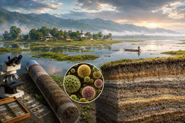
A new scientific study has opened a deep window into the environmental history of Majuli Island in Assam, reconstructing nearly 4,000 years of climate, vegetation and flood dynamics from the world’s largest inhabited river island. The research offers an important long-term perspective on how the Brahmaputra valley has responded to changing monsoon patterns, river behaviour, vegetation shifts and human pressure across centuries.
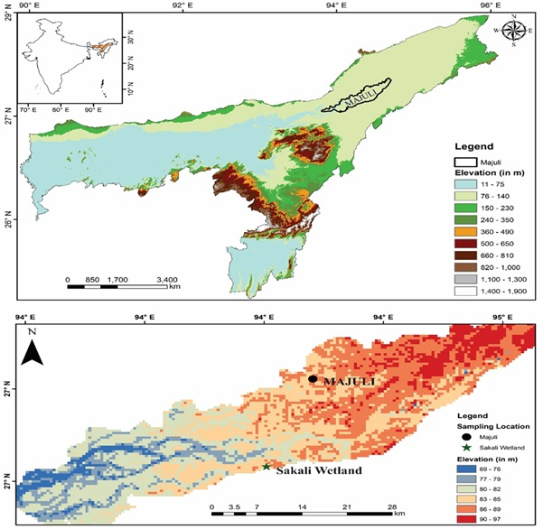
Majuli occupies a unique place in India’s geography and culture. Located within the powerful river system of the Brahmaputra and Subansiri, it is known for its living cultural heritage, tribal settlements and Neo-Vaishnavite traditions. At the same time, the island has been deeply shaped by floods, erosion and changing river courses. Its landscape carries both civilisational richness and ecological vulnerability, making it one of the most important riverine regions for studying climate adaptation.
Scientists from the Birbal Sahni Institute of Palaeosciences, Lucknow, an autonomous institute under the Department of Science and Technology, have now produced the first comprehensive palaeoecological reconstruction of Majuli based on integrated modern and fossil pollen evidence. The study fills a major scientific gap by connecting climate history, vegetation change and river processes in the Upper Brahmaputra Valley.
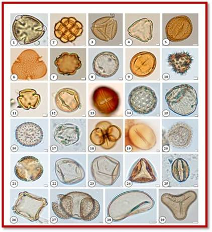
Butea monosperma, 2. Acacia nilotica, 3. Schleichera, 4. Syzygium, 5. Lagerstroemia, 6. Bombax Cieba, 7. Terminalia, 8. Emblica, 9. Sapotaceae, 10. Asteraceae, 11 & 12. Fabaceae, 13. Melastoma, 14. Chenopodiaceae, 15. Symplocos, 16. Lemna, 17. Onagraceae, 18. Typha, 19. Nymphaea, 20. Nymphoides, 21. Brassica, 22. Non-cereal, 23. Cereal, 24. Cyperaceae, 25. Coriandrum, 26. Alnus, 27. Pinus, 28. Monolete, 29. Degraded trilete.
The team collected a 150 cm deep sediment core from Sakali Wetland on Majuli Island. This sediment core functioned like a natural archive, preserving traces of past vegetation, climate conditions and river behaviour. The researchers combined pollen analysis with grain-size studies, allowing them to understand both the ecological and fluvial history of the island. Pollen helped reconstruct past vegetation, while grain-size data revealed changes in river energy, sediment movement and flood intensity.
Pollen is one of the most useful tools for understanding ancient environments because it can remain preserved in sediments for thousands of years. Different plants produce different types of pollen, and their presence in sediment layers helps scientists identify the vegetation that once existed in an area. When studied along with modern pollen analogues and climate reconstruction methods, these tiny biological records can reveal large patterns of rainfall, temperature and ecological change.
The study reconstructs environmental conditions from around 4040 to 500 calibrated years before present. During the period between 4040 and 2260 calibrated years before present, Majuli experienced a warm and humid phase with dense forest cover. This is particularly significant because the period overlaps with the 4.2 thousand-year dry climatic event, a major global climatic episode. The evidence from Majuli suggests that the island’s vegetation showed resilience during this phase, supported by favourable local ecological and hydrological conditions.
The following centuries saw changing monsoon intensity and shifting flood regimes. These fluctuations shaped vegetation patterns, wetland dynamics and sediment deposition across the island. A relatively moist period between 1100 and 500 calibrated years before present corresponds with the Medieval Climatic Anomaly, a period recognised in many parts of the world for warmer and regionally variable climatic conditions. Majuli’s sediment record shows that even remote river islands can reflect large-scale climatic patterns while also responding to local river behaviour.
The last 500 years reveal another important transition. The study points to declining temperature and precipitation, consistent with the Little Ice Age, along with rising human influence and expansion of scattered vegetation. This period shows how natural climate variability and human activity began to shape the island together. Deforestation, land-use pressure, settlement expansion and changing wetland conditions all became part of Majuli’s ecological story.
The grain-size data add another layer to this history. The evidence indicates a shift from low-energy to high-energy fluvial conditions over time. This means that the river system around Majuli became more dynamic, with stronger hydrological activity and greater instability in sediment transport. Such findings are important because Majuli continues to face recurrent flooding, riverbank erosion and land loss even today.
By combining pollen and grain-size analysis, the study helps scientists understand how climate, vegetation and river processes interact in a large river island ecosystem. This integrated approach is especially valuable for the Brahmaputra basin, where floods, erosion and sediment movement affect millions of people. Long-term scientific records can improve river management, disaster mitigation, wetland restoration and land-use planning.
The research also demonstrates that Majuli’s local ecological changes were linked with major global climatic events. This connection highlights the sensitivity of the Brahmaputra valley to wider climate forces. At the same time, the study identifies periods of resilience, showing that ecosystems can adapt under certain conditions when vegetation, water availability and river behaviour remain balanced.
For present-day policymaking, this research carries practical value. Majuli is already vulnerable to climate stress, flooding and erosion. Understanding its long-term environmental past can help planners design better adaptation strategies for communities living in flood-prone landscapes. Scientific knowledge from the past can guide future decisions on embankments, wetlands, biodiversity conservation, settlement planning and sustainable land use.
The study also strengthens the importance of palaeoscience in modern climate planning. Climate adaptation is often discussed through recent data, satellite imagery and short-term weather records. Majuli’s 4,000-year archive shows the value of deep-time evidence. It reminds policymakers that rivers, wetlands and human settlements must be understood across long timelines, especially in regions where climate variability and river instability have shaped life for centuries.
Published in the journal Review of Palaeobotany and Palynology, the research marks an important contribution to India’s environmental science. It brings together climate reconstruction, vegetation history, wetland ecology and river dynamics in one of India’s most culturally significant landscapes. For Majuli, the study is more than an academic milestone. It provides a scientific foundation for protecting a living island, its people, its biodiversity and its heritage against the pressures of a changing climate.
Publication link: https://doi.org/10.1016/j.revpalbo.2026.105536
You may also like
-
New Cascade Frog Discovery in Nagaland Highlights Northeast India’s Hidden Biodiversity
-
India’s Indigenous 6G Leap: IIT Madras and SAMEER Build Bharat 6G THz Testbed for Next-Generation Wireless Power
-
India’s Light-Powered Nano-Catalyst Opens a Cleaner Path for Making Medicines and Chemicals
-
IIT Madras Opens Advanced Maritime Research Facility to Power India’s Ship Design and Ocean Engineering Push
-
India’s CLEAR Breakthrough Could Transform Protein Imaging for Cancer and Neurological Research