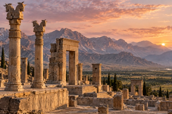
Parasika carries the geographical imagination of the Mahabharata beyond the Indus towards the Persian world. Sanskrit dictionaries identify the Parasikas as Persians, connecting the name with the ancient lands of Persia. Modern Iran provides the broad geographical correspondence, while Fars in southwestern Iran offers a more specific historical focus. The epic, however, does not define a Parasika kingdom whose boundaries can be traced precisely across a modern map.
Understanding this land requires bringing together two kinds of evidence. The Mahabharata preserves the name within its geographical account, while Persian inscriptions, monuments and historical geography help locate the civilisation associated with it. Together, they offer a clearer picture of the region without making every later Persian city a settlement mentioned in the epic.
The Persian Heartland and Its Modern Location
The strongest geographical starting point is Fars province in southwestern Iran, the historical homeland of the Persians. Its name preserves the older identity of Parsa or Pars. As Persian rulers extended their power, the name of their homeland also came to describe a much larger imperial territory. Persia consequently acquired both a narrow regional meaning and a broader political and cultural meaning.
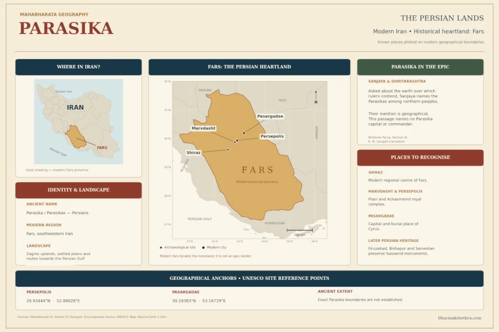
For readers locating Parasika today, the area around Shiraz, Marvdasht, Persepolis and Pasargadae provides the clearest orientation. These places belong to the Persian historical heartland. Their relevance comes from the identification of Parasika with the Persians, rather than from individual references to these cities in the Mahabharata.
Shiraz: The Modern Centre of the Persian Homeland
Shiraz is the principal modern city for understanding Fars. It became the provincial capital during the Islamic period, succeeding earlier centres such as Istakhr and Persepolis. Its position at the meeting of routes towards the Persian Gulf, Kerman, Yazd and Isfahan helped sustain its importance as a regional centre.
The area also preserves evidence of much earlier settlement. Elamite tablets from Persepolis mention a place whose name scholars connect with Shiraz, while archaeological discoveries establish a pre-Islamic history. Shiraz therefore offers a useful modern reference for the Persian homeland, although it cannot be identified as a verified capital of a Mahabharata-era Parasika kingdom.
Marvdasht and Persepolis: The Royal Landscape
Marvdasht provides a modern reference for the plain associated with Persepolis. Here, the remains of the royal complex stand at the foot of Kuh-e Rahmat. Its great terrace, monumental stairways and columned halls preserve one of the most recognisable landscapes of ancient Persian civilisation.
Darius I began the terrace around 518 BCE, and successive Achaemenid rulers added palaces and ceremonial buildings. These remains provide a documented historical setting for Persian kingship. They help readers visualise the civilisation associated with Parasika, but their archaeological dates must remain separate from any proposed chronology for the events of the Mahabharata.
Pasargadae: The Plain of Cyrus’s Capital
Farther north, Pasargadae stands in the Dasht-e Morghab plain of northern Fars. Cyrus the Great established his capital here in the sixth century BCE. The surviving royal remains and his tomb make the site an important geographical anchor for the Persian homeland.
The Pulvar River corridor and the Tang-e Bolaghi gorge historically connected this area with the Persepolis region. These features reveal a landscape of linked plains, river passages and royal settlements. Pasargadae gives substance to the identification of the Persian lands, without becoming an otherwise unattested setting for a Pandava journey or military campaign.
Mountains, Rivers and Routes Through Fars
The Persian heartland contains highland plains separated by the southern Zagros ranges. Basins such as Marvdasht supported settlement, while differences in elevation created cooler uplands and warmer southern districts. The Kor River and the irrigated Marvdasht plain are important features of this regional landscape.
Fars also connects the Iranian plateau with the Persian Gulf hinterland. Its mountain passages and basins supported movement between inland centres and the coast. This combination of cultivable land and connecting routes helps explain the region’s enduring importance in Persian history.
When Dhritarashtra Asked Sanjaya About the Earth
Parasika appears in a revealing conversation in the Bhishma Parva. Dhritarashtra asks Sanjaya about the land of Bharata, for which so many rulers have assembled and which Duryodhana covets. Sanjaya challenges the king’s account: he places responsibility for greed on Duryodhana, Shakuni and other ambitious rulers, rather than accepting that the Pandavas share the same motive.
Sanjaya then describes mountains, rivers, countries and peoples. Among the northern peoples, he includes the Parasikas, together with names such as Yavanas, Chinas, Kambojas and Hunas. The Persian people thus enter the narrative through the king’s question about the earth and the desire to possess it.
The conversation closes with a warning about kings whose appetite for territory never finds satisfaction. Sanjaya presents the earth as the support of living beings and explains its abundance when properly cared for. Geography becomes part of the epic’s reflection on responsible kingship.
This is the direct narrative setting for Parasika in Ganguli’s Bhishma Parva, Section IX. It records no Pandava visit, Persian campaign or named Parasika commander; the connection rests on the geographical catalogue within this conversation.
The Frontier Between the Indus and Iran
The intervening frontier helps explain how Indian and Iranian geographical worlds could meet. Mountain ranges west of the Indus formed substantial physical barriers, yet passes such as the Khyber and Bolan allowed movement across them. Historical scholarship therefore treats the Indo-Iranian frontier as a broad region of contact, with changing political and cultural affiliations.
Gandhara occupied an important position within this region. Achaemenid inscriptions name Gandara and Hindush among territories associated with Persian power, providing independent evidence of connections between the Iranian imperial world and the northwestern subcontinent. This historical evidence supplies context for the relationship; it does not by itself date the Mahabharata’s Parasika reference.
Persian Kings and Evidence of Contact with India
The Achaemenid period provides a documented political setting for sustained contact. Darius I extended Persian authority into parts of the northwestern subcontinent in the late sixth century BCE. Gandhara appears in the Bisotun inscription, while Hindush occurs in later royal inscriptions. These records establish specific territories and rulers independently of the Sanskrit epic.
Persian royal sculpture also represents peoples from the eastern territories. Scholars identify Gandharans, Sattagydians and Indians among figures associated with the empire’s subject nations. These representations offer material evidence of a political world extending towards the Indus, although the reliefs express imperial ideology and cannot be treated as straightforward administrative maps.
Firuzabad, Bishapur and Sarvestan: Later Persian Continuity
Other recognisable places in Fars include Firuzabad, Bishapur and Sarvestan. UNESCO groups monuments in these areas within the Sassanid Archaeological Landscape of Fars Region, preserving evidence of a later period of Persian power.
Their fortified structures, palaces and other remains show how the region continued to support major political centres. They belong to the Sassanid historical landscape, however, and cannot establish the boundaries or capital of the Parasikas mentioned in the epic. Their importance lies in demonstrating the continued prominence of the Persian homeland across successive historical periods.
A Shared Indo-Iranian Cultural Background
The relationship between ancient India and Iran also extends into religious language and ritual. Comparative scholarship identifies connections between Vedic soma and Iranian haoma, as well as between yajna and yasna. Fire, offerings and several inherited religious concepts occupied important places in both traditions, even as each developed its own teachings and practices.
These parallels help explain the deeper cultural background against which the two regions encountered one another. They do not establish a single political kingdom or make Persian religion identical with Vedic tradition. Their significance lies in shared inheritances alongside distinct historical development.
Where to Locate Parasika Today
The most useful modern identification is the Persian historical heartland in Fars, within modern Iran. Shiraz provides the principal modern urban reference, while Marvdasht, Persepolis and Pasargadae identify important parts of its ancient landscape. Later centres help explain the region’s historical continuity.
| Modern place or region | Relevance to the identification |
|---|---|
| Fars province, Iran | Historical Persian homeland and strongest regional anchor |
| Shiraz | Modern regional centre with evidence of earlier settlement |
| Marvdasht and Persepolis | Highland plain and documented Achaemenid royal landscape |
| Pasargadae and Dasht-e Morghab | Cyrus’s capital and its surrounding plain |
| Firuzabad, Bishapur and Sarvestan | Evidence of later Sassanid continuity within Fars |
These locations clarify what “ancient Persian lands” means on a modern map. They should be understood as places within the historical homeland associated with the Parasikas, rather than as an independently verified list of cities belonging to one precisely bounded epic kingdom.
Parasika’s importance lies in the connection between a name preserved in Sanskrit literature and a recognisable historical civilisation. Its study brings the Mahabharata’s geographical account into conversation with the plains, rivers, cities and monuments of Iran. That connection becomes more meaningful when the epic reference and the archaeological record retain their distinct roles.
References
Kisari Mohan Ganguli, The Mahabharata, Bhishma Parva, Section IX; Sanskrit dictionary entries under Pārasika and Pārasīka, reproduced by Wisdom Library; Encyclopaedia Iranica, Fars—Geography, Shiraz—History, Pasargadae, India—Historical Geography, India–Iran Relations in the Achaemenid Period, and Indo-Iranian Religion; UNESCO World Heritage Centre, Pasargadae, Persepolis, and Sassanid Archaeological Landscape of Fars Region.
You may also like
-
Kapisa: The Ancient Kingdom North of Kabul at the Gateway of the Hindu Kush
-
Lampaka: The Mountain Kingdom of Laghman on the Kabul River Frontier
-
Navaratri and Ayurveda: The Nine Divine Medicinal Plants Associated with Navadurga
-
Bahlika: The Ancient Bactrian Realm of Balkh in the Mahabharata
-
Kamboja: The Horse-Breeding Frontier Kingdom of the Hindu Kush in the Mahabharata
