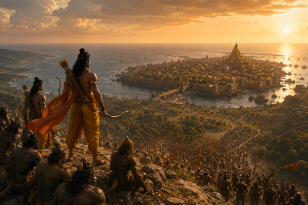
When Rama’s army reached Lanka, the war had already passed through its first great test. The ocean had been crossed, the bridge had become a corridor of invasion, and the Vanara host now stood on enemy soil. Before the first full assault against Ravana’s citadel, Rama chose elevation. He ascended Suvela mountain, stood above the plain, and looked upon Lanka as a commander studies a living map.
This was a strategic act. From Suvela, Lanka was no longer a distant golden city filled with rumour, fear and enemy prestige. It became a defined military objective. Its walls, gates, towers, roads, royal quarters, watch posts and defensive concentrations could be studied in relation to one another. The mountain gave Rama the one gift every commander seeks before battle: perspective.
High ground is one of the oldest military advantages known to warfare. It gives the army sight, control, confidence and timing. A force standing below sees obstacles. A commander standing above sees routes. Below, the battlefield appears as fragments — a gate here, a tower there, a cloud of dust, a banner, a moving column. From height, those fragments join into a pattern. Suvela converted the fortress of Lanka into a readable system.
In modern military language, this is called terrain appreciation. Before an army fights, it must understand the ground. The shape of the land decides movement, visibility, fatigue, supply, communication, firing positions, ambush risks, staging areas and withdrawal routes. A wise commander studies ridgelines, valleys, approaches, choke points, water sources, roads, open spaces, built-up areas and natural obstacles. Rama’s climb to Suvela is an ancient example of this disciplined military habit.
The first advantage of high ground is observation. From Suvela, Rama could examine Lanka before entering its killing zone. The walls could be studied for strength. The gates could be compared for access. The routes into the city could be judged for movement. The enemy’s visible deployment could be understood through the arrangement of guards, banners, chariots and armed formations. In a siege, this kind of observation becomes the opening strike, because the commander first attacks uncertainty.
Modern armies perform this same function through hilltop observation posts, long-range cameras, battlefield radars, reconnaissance drones, satellites, aerostats and surveillance aircraft. The mountain has become a sensor grid. The eye of the commander now extends through electro-optical systems, thermal imagers, synthetic aperture radar and live data feeds. Yet the principle remains exactly the same as Suvela: rise above the confusion, see the whole battlefield, and act only after the terrain has spoken.
The second advantage is command. A commander on high ground can understand where his army should be placed. Rama’s Vanara force was vast, mobile and energetic, but raw energy requires direction. From Suvela, he could imagine where shock troops should gather, where reserves could stand, where scouts should move, where messengers could run, and where the main pressure should fall. The mountain gave him the ability to convert a mass of warriors into a shaped assault force.
Modern command posts use the same logic. A headquarters positioned with good visibility, communication reach and protected access can coordinate movement across several formations. Radios, satellite links, fibre networks and battlefield management systems have replaced shouted orders and runners, but command still depends on a clear view of the operational picture. A commander who understands the full field can allocate strength with precision.
The third advantage is morale. When Rama’s army stood on Suvela and saw Lanka before them, the objective became real. The city that had once existed across the sea, inside rumour and fear, now stood visible under the sky. Soldiers draw courage from clarity. An army that can see its target feels the nearness of victory. The Vanaras could look at the golden city and understand that the campaign had reached its decisive ground. Their long march, their leap across the sea, their labour on the bridge and their faith in Rama had brought them to the edge of destiny.
High ground has always carried this psychological power. A flag raised on a ridge can lift an army’s spirit. A captured peak can break the enemy’s confidence. A commander seen standing above the field becomes a symbol of control. In the Kargil War, the struggle for heights such as Tololing and Tiger Hill acquired immense military and emotional force because altitude became prestige, visibility and battlefield influence in one. The ridge was a weapon, a watchtower and a symbol.
A powerful modern Indian parallel is the Kargil War of 1999, where high ground became the decisive language of the battlefield. Pakistani intruders had occupied steep ridgelines and icy heights overlooking key approaches near the Srinagar–Leh axis, giving them observation over Indian movement, supply routes and artillery activity. For the Indian Army, the campaign became a brutal test of climbing into fire, because every captured peak restored visibility, command confidence and control over the valley below. The battles for Tololing, Point 4875 and Tiger Hill showed how altitude can dominate an entire sector: troops had to advance through near-vertical slopes, freezing winds, exposed rock faces and enemy fire from above, while artillery, reconnaissance and infantry assault teams worked together to turn the heights back into Indian observation posts. Once the ridgelines were recaptured, the enemy’s advantage collapsed because the same geography that had earlier helped them watch Indian movement now allowed Indian forces to observe, direct fire, secure approaches and regain psychological command of the theatre. This is the modern Suvela principle in action — the army that controls the height controls the view; the army that controls the view controls timing, movement, fire and morale.
The fourth advantage is security. A force that occupies height can detect movement earlier. Enemy patrols, hidden columns, supply convoys, reinforcements and sudden sorties become easier to observe from above. At Suvela, Rama could reduce surprise by studying the approaches around Lanka and watching the enemy’s visible rhythm. A commander who sees movement early gains time, and time is one of the most valuable currencies in war.
Modern border posts in mountainous terrain depend on this principle. A post on a height can watch valleys, tracks and approaches that remain hidden from lower ground. Surveillance radars and optical devices placed on elevated locations extend detection range. In maritime geography, island territories perform a similar role. The Andaman and Nicobar Islands, for example, sit near vital sea lanes and provide India with a natural vantage in the eastern Indian Ocean. Height, distance and location combine to produce awareness.
The fifth advantage is fire control. In ancient warfare, height improved the use of arrows, stones and thrown weapons. A defender or observer on higher ground could judge distance more clearly and support fighters below with guidance. In modern warfare, high ground helps artillery observers, air controllers, missile units and surveillance teams direct fire with greater accuracy. The ability to see the enemy’s movement turns terrain into an extension of the weapon.
This does not mean every high point becomes a firing position. Some heights serve better as observation posts, communication nodes or staging areas. The wisdom lies in assigning the correct military function to the correct piece of ground. Suvela’s role was observation and planning. It gave Rama the battlefield picture before the main clash. That distinction matters because intelligent use of terrain begins with purpose.
The sixth advantage is communication. Height extends reach. A signal from a ridge travels farther than one sent from a hollow. In ancient battle, this could mean visible banners, conches, drums, torch signals or messenger routes. From elevated ground, commanders could coordinate formations and maintain awareness across a wider field. Suvela gave Rama’s command a natural centre from which the army could orient itself.
Modern forces depend even more heavily on this principle. Hilltops host relay stations, radio equipment, radars and communication infrastructure. In high-altitude theatres, a single ridge can strengthen the network of an entire formation. Command and control in difficult terrain often depends on holding or accessing elevated points that allow signals to move across broken land. In the digital battlefield, geography still matters; the radio wave also respects terrain.
The seventh advantage is route selection. A siege force must understand how to approach the objective. Direct movement towards a fortified gate may consume strength. A longer route may offer better cover, easier massing or safer staging. From Suvela, Rama could compare approaches to Lanka’s gates and walls. The mountain allowed him to see the relationship between open ground, defensive structures and possible assembly areas.
Modern armies call this movement planning. Armoured columns, infantry formations, logistics convoys and assault units all depend on routes that match their purpose. The best route for reconnaissance may be poor for heavy vehicles. The best path for supplies may be different from the best axis for assault. Terrain decides tempo. A commander who understands the land can move with rhythm instead of exhaustion.
The eighth advantage is intelligence fusion. Vibhishana had already given Rama valuable information about Lanka — its rulers, commanders, internal structure and defensive habits. From Suvela, that information could be matched against visible reality. A gate mentioned in a report could be seen. A defensive sector described by a defector could be placed in the mind’s map. Human intelligence and terrain observation fused into battlefield understanding.
This is exactly how modern operations combine sources. A human source may reveal an enemy camp. A drone may confirm movement. Satellite imagery may show construction. Signals intelligence may indicate communication. Ground reconnaissance may verify access. The strongest military decisions emerge when many streams of information converge. Suvela was the place where Rama’s received intelligence gained physical shape.
The ninth advantage is economy of force. A commander who sees clearly wastes fewer soldiers. He sends strength where it can create effect. He holds reserves where they can influence the battle. He avoids scattering troops across every visible threat. Lanka’s massive appearance could have tempted a reckless commander into spreading his force across all walls and gates. Rama’s view from Suvela helped convert scale into selectivity.
This remains central to modern war. Every force has limits, even a large one. Ammunition, fuel, manpower, time, medical support, transport capacity and command attention must be used with discipline. High ground allows the commander to identify decisive points, avoid unnecessary dispersal and preserve momentum. Terrain intelligence protects lives by replacing impulse with judgement.
The tenth advantage is psychological pressure on the enemy. A besieged force understands when the attacker has studied the ground. When Ravana’s watchers saw Rama’s army on the heights, they would have known that the enemy had arrived in strength, confidence and order. The sight of an army calmly observing a fortress before assault carries its own message: the attacker is preparing, measuring and choosing.
Modern warfare also uses visible positioning to create pressure. Exercises, deployments, high-altitude posts, forward logistics bases and surveillance activity communicate intent. A force that holds the commanding ground shapes the enemy’s imagination. The enemy begins to calculate, reinforce, reposition and worry. High ground influences the mind before weapons influence the body.
A complete high-ground doctrine has several layers. The first layer is reconnaissance. Before occupation, scouts must understand the height — access routes, water availability, concealment, enemy observation, weather, slope, nearby cover and communication value. Suvela was chosen because it overlooked Lanka and gave Rama a clear command view. Every height has a personality. Some dominate the battlefield. Some exhaust the troops. Some expose the force. Some become traps during weather changes. The commander must know the difference.
The second layer is occupation. A height becomes useful only when the force can hold it long enough to extract value from it. That requires sentries, scouts, messenger routes, protected positions, rotation of tired troops, medical readiness and supply support. In modern terms, the occupation of height also involves camouflage, power supply, communications equipment, surveillance devices and protection from enemy fire. A mountain is an advantage only when it becomes part of the army’s system.
The third layer is observation discipline. A vantage point should produce meaningful information. Soldiers posted there must watch patterns, count movement, identify command areas, note route usage, detect reinforcement, study smoke, dust, sound and light. In the Ramayana setting, this could mean reading the movement of Rakshasa guards, the activity near gates, the rhythm of chariot movement and the concentration of elite warriors. In modern war, it means observing heat signatures, vehicle tracks, communication masts, supply dumps and unusual movement.
The fourth layer is communication flow. Intelligence gathered from height must travel quickly to the commander. A watcher who sees movement and fails to transmit it in time becomes a silent spectator. Suvela’s value came from its connection to Rama’s command mind. Modern armies build this through radios, data links, map grids, encrypted networks and command posts. The military worth of high ground increases when observation becomes decision at speed.
The fifth layer is logistics. Heights are difficult to supply. Food, water, ammunition, batteries, medical material and equipment must climb with the soldier. In ancient warfare, this meant carrying water skins, fruit, roots, weapons and messages along rough paths. In modern war, it means mule columns, helicopters, drones, special vehicles, rope systems, porters and high-altitude stores. A height that cannot be supplied becomes a temporary view. A height that can be sustained becomes a fortress.
The sixth layer is weather management. Mountains change mood quickly. Wind, fog, rain, cold, heat shimmer and darkness can alter visibility and movement. A commander who uses high ground must understand time of day, season and climate. Dawn may reveal movement. Noon may distort distance. Night may hide approach routes. Clouds may blind sensors. The ancient commander watched sky and wind. The modern commander reads weather reports, satellite data and sensor performance charts. Both are servants of the same truth: terrain and weather fight together.
The seventh layer is camouflage and concealment. A force on height gains visibility while also becoming visible. Skill lies in watching the enemy while reducing one’s own exposure. In ancient warfare, rocks, trees, shadows and slope lines offered concealment. In modern warfare, camouflage nets, thermal discipline, dispersed positions, electronic emission control and decoy structures shape survival. The best high-ground position observes widely and reveals little.
The eighth layer is reserve placement. High ground can help a commander decide where to keep fresh troops. Rama could see where the battle might thicken, where pressure might build and where a sudden push might be needed. A reserve placed intelligently can decide the moment. Modern formations use reserves in the same way — to reinforce success, seal a breach, support a threatened flank or exploit a sudden opening.
The ninth layer is flank awareness. A hill or ridge often reveals side routes that ground troops miss. Armies suffer when they focus only on the wall ahead and forget the movement around them. Suvela would have allowed Rama to understand Lanka’s wider approaches, not simply its front-facing grandeur. Modern commanders use elevated surveillance to watch lateral tracks, bypass routes, ravines, coastal approaches and hidden assembly areas.
The tenth layer is withdrawal and continuity. A commander must think beyond the first assault. If the attack slows, where will troops regroup? If wounded need evacuation, which route serves them? If reserves move forward, how will they pass through the first line? If night falls, where will units assemble? High ground helps answer these questions before chaos begins. Rama’s calm survey from Suvela represents this deeper preparation.
The Ramayana’s genius lies in the way it places such military realism inside a sacred story. Rama is righteous, but righteousness alone does not arrange an army. Dharma gives him purpose; strategy gives him method. Suvela shows him as a commander who studies before striking, observes before ordering, and understands that courage must be guided by terrain.
Lanka itself becomes a textbook objective. It is a fortified island city with walls, gates, towers, elite defenders, internal command structure and royal prestige. A direct assault against such a place requires more than bravery. The attacker must break the defender’s confidence, identify command nodes, disrupt reinforcement, control approaches and maintain morale through prolonged combat. Suvela gave Rama the first complete picture of this challenge.
In modern urban warfare, the same pattern appears in a different form. A city is studied through drones, satellite imagery, building maps, street grids, population movement, communication signals and underground routes. Tall buildings, ridges outside the city and airborne platforms provide vantage. Commanders must understand where roads narrow, where defenders can concentrate, where civilians may be present, where supplies move and where reserves can be staged. Lanka was an ancient fortified city; the method of studying it from height remains timeless.
For India, the doctrine of high ground carries special relevance because geography itself is strategic. The Himalayas demand mastery of altitude. The deserts require control of observation points and movement corridors. The coastline requires radar chains and maritime watch. The island territories create oceanic vantage. The Northeast demands terrain intelligence across hills, forests and river valleys. In each theatre, the commander who understands height gains a sharper sense of distance, direction and danger.
Kargil remains one of the clearest modern examples. Enemy-held heights overlooking key routes created a severe tactical challenge. Indian forces had to climb under difficult conditions, fight uphill, restore control over ridges and regain observation advantage. The battles showed that high ground can influence supply lines, artillery correction, morale and national attention. The mountain became both battlefield and symbol.
Siachen offers another lesson. The occupation of high-altitude positions in harsh conditions shows that holding height requires endurance beyond combat. Weather, logistics, medical care, acclimatisation and engineering become part of strategy. A post at altitude is sustained by an invisible chain of supply, training and resilience. The soldier on the height stands there because an entire system keeps him alive.
In maritime strategy, “high ground” has expanded into the sky and space. Satellites, long-range maritime patrol aircraft, drones and island-based sensors create an elevated view over the ocean. A navy that sees distant movement can protect sea lanes, detect suspicious vessels and guide ships with confidence. The ancient hilltop has become the orbital sensor and the coastal radar. Suvela’s principle now watches the seas.
In cyber and information warfare, the phrase “high ground” has become metaphorical as well. The side that controls information, narrative, networks and data flows gains a form of altitude over the opponent’s decision-making. A commander who understands the battlefield faster than the enemy gains temporal high ground. Speed of awareness becomes a height of its own. Rama’s Suvela moment can be read as the first step in decision superiority — he shaped his understanding before Ravana could shape the battle.
Height is valuable because it converts land into knowledge. Its purpose is to see, coordinate, protect, inspire and decide. The commander who climbs for vanity gains a view. The commander who climbs for strategy gains control.
The Suvela episode also teaches restraint. Rama does not rush blindly after crossing the sea. The army has already achieved a magnificent engineering and morale feat by reaching Lanka. Many commanders would have allowed momentum to become impatience. Rama pauses, observes and studies. This pause is strategic maturity. The best offensives often begin with stillness — the stillness of a commander absorbing the field before unleashing movement.
The scene can be imagined with cinematic force. The Vanara army spreads below the mountain like a living tide — banners snapping in the sea wind, commanders gathering near Rama, scouts pointing towards the city, dust rising from thousands of feet. Beyond them, Lanka glows under the sun, its towers sharp against the sky, its walls crowded with armed Rakshasas, its gates heavy with menace. Rama stands on Suvela, bow in hand, calm amid the pressure of history. Beside him, Lakshmana watches with the intensity of a warrior waiting for command. Vibhishana identifies landmarks of the city he once called home. The battlefield below becomes a scroll, and Rama reads it line by line.
That is the essence of high-ground warfare. The commander rises above emotion and sees structure. He transforms fear into geography, geography into plan, plan into movement, and movement into victory. Suvela is not merely a mountain in the Lanka campaign. It is the first command post of the final war.
Every great battle has its Suvela moment — the point where the leader steps above the noise and sees the whole design. Before the charge, before the siege, before the clash of heroes, there is the quiet act of looking. Rama’s army would soon descend into the violence of Lanka’s war, but its strategic clarity was born on the height. In that moment, the mountain became more than stone. It became intelligence, morale, command and destiny.
You may also like
-
Madhur Anantheshwara Vinayaka Temple: Kasaragod’s Celebrated Riverside Shrine
-
ideaForge: The Indian Drone Pioneer Building Surveillance and Heavy-Lift Logistics UAVs
-
Indian Navy Launches DSC A24, Final Vessel in Indigenous Diving Support Craft Programme
-
India–China Border Trade Reopens Through Three Himalayan Routes After Six-Year Suspension
-
Ajit Doval Receives Lokmanya Tilak National Award, Calls on Youth to Place Nation Above Personal Interest