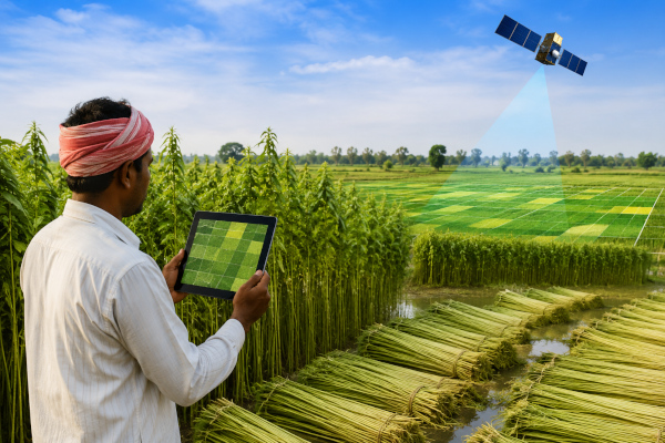
India’s jute sector is entering a new phase of technology-led monitoring, with the National Jute Board stepping up implementation of the Jute Crop Information System, or JCIS, a platform developed in collaboration with the Indian Space Research Organisation and the Jute Corporation of India. The system brings together satellite intelligence, weather analytics and field-level inputs to improve the monitoring of jute cultivation across producing regions. According to the Ministry of Textiles, NJB has been implementing JCIS since 2023 to monitor jute cultivation through remote sensing and field data.
The importance of the system lies in the long-standing data gap in the jute ecosystem. Earlier, crop area and yield estimates often depended on fragmented inputs, manual field collection and expert assessments, which could lead to delays and inconsistency. JCIS changes this approach by combining satellite-based crop mapping, vegetation indices, historical datasets, weather inputs and mobile-based field observations into one integrated platform. This allows near-real-time estimation of jute crop area and production, continuous crop-condition monitoring, automated reporting and timely alerts.
Two key digital tools have been developed under the initiative. The first is BHUVAN JUMP, a mobile application used for on-field jute monitoring. The second is PATSAN, or Prospective Assessment of Jute Using Mobile App-Based Field Observations, a web-based platform that provides near-real-time jute surveillance and analytics for officials and stakeholders. These tools help connect satellite observations with ground-level data, making crop estimates more reliable and actionable.
The National Jute Board’s role has been central because it connects the technology platform with field execution. Through its I-CARE field network, NJB has helped collect large volumes of geo-tagged field data using the BHUVAN JUMP mobile app. It has also supported crop-cutting experiments through a geospatial smart-sampling framework, where satellite-derived crop maps are combined with statistically robust sampling techniques to improve yield estimation and production modelling.
The system is particularly important for a crop that is vulnerable to floods, drought, pests and temperature variations. JCIS includes a quantitative flood-impact model supported by satellite observations and field validation, helping officials estimate yield and quality losses in affected areas more objectively. Weather analytics also support early warnings on rainfall patterns, dry spells and temperature changes, allowing district-level planners to respond faster.
For India’s jute economy, the move is significant because jute is not only a traditional cash crop but also a strategic natural fibre at a time when biodegradable and eco-friendly materials are gaining importance as alternatives to single-use plastics. The National Crop Forecast Centre notes that jute remains important for rural livelihoods, domestic demand and export potential, while government initiatives such as MSP support, Jute-ICARE and the National Jute Development Programme are aimed at improving cultivation, retting, productivity and farmer income.
The next phase of JCIS is expected to focus on expanding coverage to more districts and high-potential jute-growing regions, strengthening farmerIndia’s jute sector is entering a new phase of technology-led monitoring, with the National Jute Board stepping up implementation of the Jute Crop Information System, or JCIS, a platform developed in collaboration with the Indian Space Research Organisation and the Jute Corporation of India. The system brings together satellite intelligence, weather analytics and field-level inputs to improve the monitoring of jute cultivation across producing regions. According to the Ministry of Textiles, NJB has been implementing JCIS since 2023 to monitor jute cultivation through remote sensing and field data.
The importance of the system lies in the long-standing data gap in the jute ecosystem. Earlier, crop area and yield estimates often depended on fragmented inputs, manual field collection and expert assessments, which could lead to delays and inconsistency. JCIS changes this approach by combining satellite-based crop mapping, vegetation indices, historical datasets, weather inputs and mobile-based field observations into one integrated platform. This allows near-real-time estimation of jute crop area and production, continuous crop-condition monitoring, automated reporting and timely alerts.
Two key digital tools have been developed under the initiative. The first is BHUVAN JUMP, a mobile application used for on-field jute monitoring. The second is PATSAN, or Prospective Assessment of Jute Using Mobile App-Based Field Observations, a web-based platform that provides near-real-time jute surveillance and analytics for officials and stakeholders. These tools help connect satellite observations with ground-level data, making crop estimates more reliable and actionable.
The National Jute Board’s role has been central because it connects the technology platform with field execution. Through its I-CARE field network, NJB has helped collect large volumes of geo-tagged field data using the BHUVAN JUMP mobile app. It has also supported crop-cutting experiments through a geospatial smart-sampling framework, where satellite-derived crop maps are combined with statistically robust sampling techniques to improve yield estimation and production modelling.
The system is particularly important for a crop that is vulnerable to floods, drought, pests and temperature variations. JCIS includes a quantitative flood-impact model supported by satellite observations and field validation, helping officials estimate yield and quality losses in affected areas more objectively. Weather analytics also support early warnings on rainfall patterns, dry spells and temperature changes, allowing district-level planners to respond faster.
For India’s jute economy, the move is significant because jute is not only a traditional cash crop but also a strategic natural fibre at a time when biodegradable and eco-friendly materials are gaining importance as alternatives to single-use plastics. The National Crop Forecast Centre notes that jute remains important for rural livelihoods, domestic demand and export potential, while government initiatives such as MSP support, Jute-ICARE and the National Jute Development Programme are aimed at improving cultivation, retting, productivity and farmer income.
The next phase of JCIS is expected to focus on expanding coverage to more districts and high-potential jute-growing regions, strengthening farmer advisory systems through mobile and SMS alerts, integrating JCIS data into scheme design and resource allocation, and using advanced analytics for sustainability-related areas such as water-resource mapping and carbon-linked interventions. In practical terms, the system marks a shift from delayed and fragmented crop estimation to a more scientific, satellite-supported and evidence-based model for managing India’s jute sector. advisory systems through mobile and SMS alerts, integrating JCIS data into scheme design and resource allocation, and using advanced analytics for sustainability-related areas such as water-resource mapping and carbon-linked interventions. In practical terms, the system marks a shift from delayed and fragmented crop estimation to a more scientific, satellite-supported and evidence-based model for managing India’s jute sector.
You may also like
-
World Bank Approves $890 Million to Accelerate India’s Rooftop Solar Expansion
-
India’s Exports Rise 11.37% to $232.73 Billion in First Quarter of 2026–27
-
India’s Kharif Sowing Area Reaches 531.25 Lakh Hectares by July 10, 2026
-
India Expands Maize-Based Ethanol Production as E20 Fuel Programme Advances
-
India’s Food Services Market Expected to Reach US$150 Billion by FY31: Report