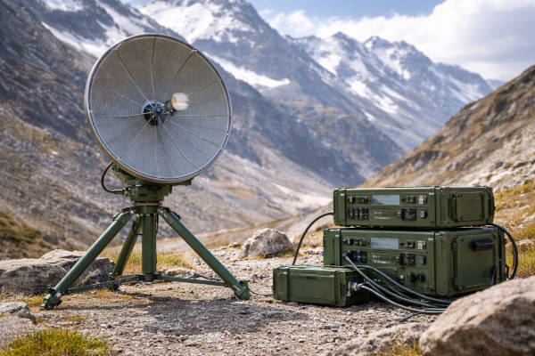
A mountain can break a radio network as efficiently as enemy fire. Valleys swallow line of sight, ridgelines carve dead zones, and physical backhaul takes time to push into forward areas. DRDO’s Compact Transhorizon Communication System (CTCS) is designed for exactly that kind of battlefield geometry. Developed by the Defence Electronics Applications Laboratory (DEAL), Dehradun, CTCS is a C-band man-portable troposcatter communication system meant to establish beyond-line-of-sight links between tactical locations, user stations and remote posts, especially in areas where the civil communications grid is absent. DRDO states that the system supports up to 60 km in troposcatter mode and up to 100 km in line-of-sight mode.
DRDO describes CTCS as a three-part package comprising the radio unit, the antenna assembly, and an alignment and pointing mechanism mounted on a lightweight tripod. Trans-horizon links demand careful beam geometry. Even a compact field system needs disciplined antenna pointing, stable alignment and a workable planning process if it is to deliver consistent throughput in broken terrain. CTCS also includes link prediction software with integrated GIS data for offline link planning and feasibility analysis, which gives operators a practical planning layer before the radios ever go on air.
The heart of CTCS is its use of troposcatter propagation. In plain language, that means the system throws RF energy toward the lower atmosphere and exploits scattering in the troposphere to push a signal beyond the geometric horizon. This is a classic answer to the “last ridge” problem: two terminals gain a trans-horizon path even when a direct optical link becomes difficult. ITU guidance on trans-horizon radio-relay systems explains why this class of communication is demanding. The received signal varies with frequency and time, propagation introduces rapid fluctuations and multipath effects, and engineers therefore lean on high-gain antennas, low-noise receivers, diversity techniques, adaptive equalisation and careful modem design to keep the link stable. Seen through that lens, CTCS is far more than a rugged field radio; it is a specialised microwave relay architecture compressed into a portable military form.
The C-band choice is significant as well. DRDO identifies CTCS explicitly as a C-band system, while ITU recommendations for trans-horizon radio-relay design emphasise that frequency-band selection sits at the center of the trade between received signal level, usable bandwidth and overall system behaviour. In practical military terms, that pairing suggests a design that seeks a workable balance between field portability, antenna size, throughput ambition and propagation performance. CTCS therefore occupies an important middle space: heavier and more deliberate than a handheld tactical radio, yet far more mobile than a permanent communications installation.
A clearer picture of the intended military role appears in the Ministry of Defence’s Technology Perspective and Capability Roadmap 2025. The document lists a Compact Tropo-scatter Communication System as a light-weight deployable system capable of establishing trans-horizon links over 60–100 km, with throughput of 200 Mbps, built-in secrecy, and software-based RF/link analysis and planning. The same roadmap indicates an expected life cycle of 15 years and an approximate quantity of 20–25 pairs, with the status marked as developed by DRDO. That is an important clue. It suggests CTCS sits in the category of operationally relevant field communications rather than a laboratory curiosity.
That feature set has real battlefield value. A portable trans-horizon backhaul link can support border outposts, temporary command nodes, surveillance detachments, gun areas, logistics echelons and emergency restoration of communications after terrain disruption or infrastructure damage. This is an inference from the official description of CTCS as a system for tactical locations, remote locations, and high-data-rate low-latency connectivity in difficult hilly terrain. In Indian conditions, where altitude, weather and topography shape every communications plan, a deployable terrestrial backhaul layer offers commanders something extremely useful: bandwidth without waiting for roads, trenches or towers to catch up.
DRDO’s industry page says the system was developed against an Indian Army requirement, that the Army has formulated the QR for induction, and that industry partners are in the process of signing Transfer of Technology agreements for production. DRDO’s May 2025 newsletter adds another useful signal: during a visit to DEAL, BEL Panchkula reviewed ongoing programmes including CTCS, and BEL’s team appreciated DEAL’s support toward Transfer of Technology of CTCS. That indicates the project has moved into the industrialisation phase, which is often the hardest stretch for communications equipment because ruggedisation, repeatability, maintainability and user support decide whether a clever design becomes a durable military capability.
CTCS therefore represents a very specific kind of military strength. It carries neither the glamour of a missile nor the spectacle of a radar, yet it addresses a foundational military truth: formations fight at the speed of their links. In the Himalayas, along remote border belts, and across any battlespace where terrain keeps slicing apart the radio picture, a compact troposcatter node can become the invisible bridge that holds the force together. That is where CTCS fits into India’s defence ecosystem as a quiet, technical, field-deployable communications asset built to carry command, coordination and data across the ground that usually defeats them.
Reference:
https://drdo.gov.in/drdo/sites/default/files/tot/CTCS31052024.pdf
https://drdo.gov.in/drdo/en/industry-partner?page=4
https://www.mod.gov.in/dod/sites/default/files/FINAL-TPCR-2025_0.pdf
https://www.itu.int/dms_pubrec/itu-r/rec/f/R-REC-F.1106-0-199409-I!!PDF-E.pdf
https://www.itu.int/dms_pub/itu-r/opb/hdb/R-HDB-54-2009-OAS-PDF-E.pdf
https://drdo.gov.in/drdo/sites/default/files/publication-document/NL_May2025.pdf
You may also like
-
Indian Army Partners with Zoho to Strengthen Indigenous Digital Transformation
-
India and Morocco Strengthen Counter-Terrorism Cooperation at New Delhi JWG Meeting
-
Rajnath Singh–Amir Baram Meeting Signals Deeper India–Israel Defence Partnership
-
India’s Defence Production Crosses Record ₹1.78 Lakh Crore, Strengthening Atmanirbhar Bharat Push
-
US Notifies Support Package for India’s Apache Helicopters and M777A2 Howitzers