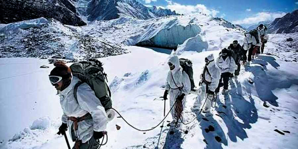
In the extreme operational theatres along India’s northern frontiers—where altitude, terrain, and weather routinely inflict greater casualties than combat—the need for persistent situational awareness and rapid rescue capability has driven the development of specialized soldier systems. Among these, NATSAT (Navigation with Satellite Tracking), developed by the Defence Research and Development Organisation (DRDO), represents a critical evolution in high-altitude survivability, combining satellite-based tracking, emergency signalling, and avalanche response integration into a compact, field-deployable terminal.
NATSAT is fundamentally designed to address the time-critical nature of avalanche survival, where the probability of recovery drops sharply beyond the first 10–15 minutes of burial. Conventional avalanche beacons, typically operating on short-range RF transmission, require search teams to be in proximity and depend heavily on line-of-sight and terrain accessibility. NATSAT departs from this paradigm by incorporating beyond-line-of-sight satellite communication, enabling continuous positional awareness of soldiers irrespective of terrain masking, weather conditions, or communication blackouts. This transforms avalanche response from a localized search problem into a network-coordinated retrieval operation, significantly reducing response latency.
Technically, the system integrates a Global Navigation Satellite System (GNSS) receiver with a satellite uplink module, likely interfacing with India’s INSAT/GSAT constellation or equivalent military communication satellites. This architecture allows each terminal to periodically transmit geospatial coordinates to a central command node, creating a real-time or near-real-time digital map of troop disposition in high-altitude zones. In the event of an avalanche or emergency, the system can trigger a distress signal, either manually by the soldier or potentially through automated detection mechanisms linked to motion or impact thresholds, immediately flagging the last known position to command centres.
From a systems engineering perspective, NATSAT is optimized for extreme environmental resilience. Electronics are ruggedized to operate in sub-zero temperatures, where battery efficiency, signal stability, and material integrity become critical challenges. The device is expected to employ low-power communication protocols to maximize operational endurance during long patrol cycles, while maintaining sufficient transmission strength for reliable satellite connectivity. The form factor is designed to be compact and wearable, ensuring that it does not interfere with mobility, weapon handling, or load carriage systems.
A key aspect of NATSAT’s operational value lies in its integration with avalanche forecasting and terrain intelligence systems, such as those developed by the Snow and Avalanche Study Establishment (SASE). By linking real-time soldier location data with hazard maps and predictive models, command units can dynamically assess risk exposure, reroute patrols, and issue warnings. This creates a layered system where prediction, monitoring, and response are interconnected, enhancing both preventive and reactive capabilities.
Beyond avalanche scenarios, NATSAT functions as a force tracking and navigation system in communication-denied environments. High-altitude operations often involve whiteout conditions, glacial crevasses, and terrain where traditional navigation aids are unreliable. In such contexts, continuous satellite-linked tracking ensures that each soldier remains part of a digitally connected operational grid, enabling better coordination, reduced risk of disorientation, and improved command oversight. The system effectively acts as a node in a network-centric battlefield architecture, where individual soldiers contribute to a shared operational picture.
Compared to legacy systems, NATSAT represents a significant leap in capability. Traditional avalanche transceivers are limited to short-range detection (typically under 100 meters) and require manual search procedures, whereas NATSAT provides global or theatre-wide visibility through satellite linkage. This expanded range, combined with command-level integration, allows for faster deployment of rescue teams, optimized routing, and potentially the integration of aerial assets such as UAVs or helicopters for rapid extraction.
From a doctrinal standpoint, NATSAT reflects a broader shift in military thinking—from equipping soldiers with isolated survival tools to embedding them within integrated, data-driven survivability systems. It aligns with India’s ongoing efforts toward digitized infantry and network-centric warfare, where information flow is as critical as firepower. In high-altitude deployments, where logistics are constrained and environmental risks are constant, such systems provide a force multiplier effect without increasing physical burden.
The system also carries implications beyond military use. Its architecture can be adapted for disaster response, mountaineering safety, and civilian avalanche rescue operations, particularly in regions prone to snow disasters. Integration with future technologies such as AI-based hazard prediction, biometric monitoring, and autonomous rescue platforms could further enhance its capability.
In essence, NATSAT addresses one of the most persistent challenges of high-altitude warfare: the unpredictability of the environment. By ensuring that every soldier remains trackable, connected, and recoverable, even under snow burial or communication blackout, it shifts the balance from vulnerability to resilience. In terrains where nature itself is the primary adversary, such systems redefine survivability as a function of technology, connectivity, and time-critical response rather than chance.
Reference:
https://www.drdo.gov.in/
https://www.drdo.gov.in/labs-and-establishments/defence-electronics-applications-laboratory-deal
https://www.drdo.gov.in/labs-and-establishments/snow-and-avalanche-study-establishment-sase
https://idrw.org/drdos-natsat-system-for-avalanche-warning-and-soldier-tracking/
https://www.financialexpress.com/business/defence-drdo-develops-natsat-system-for-soldier-safety-in-avalanche-prone-areas-3501234/
https://www.army-technology.com/features/avalanche-protection-systems-military/
https://www.sciencedirect.com/science/article/pii/S1877705819310930
https://ieeexplore.ieee.org/document/8951234
You may also like
-
Indian Army Partners with Zoho to Strengthen Indigenous Digital Transformation
-
India and Morocco Strengthen Counter-Terrorism Cooperation at New Delhi JWG Meeting
-
Rajnath Singh–Amir Baram Meeting Signals Deeper India–Israel Defence Partnership
-
India’s Defence Production Crosses Record ₹1.78 Lakh Crore, Strengthening Atmanirbhar Bharat Push
-
US Notifies Support Package for India’s Apache Helicopters and M777A2 Howitzers