
In a significant scientific breakthrough, researchers have decoded the long and dramatic geological evolution of the Ladakh Magmatic Arc in the northwestern Himalaya, offering fresh insight into how one of Earth’s most remarkable mountain regions was formed. Their findings help reconstruct nearly 130 million years of tectonic history, tracing the subduction, maturation, and eventual collision of the Indian and Eurasian plates that helped shape the Himalaya.
Long before the Himalaya rose into the world’s highest mountain system, the region we now know as Ladakh lay above an ancient ocean called the Neo-Tethys Ocean. Beneath that ocean, a colossal geological process was unfolding. Massive slabs of oceanic crust were sinking deep into the Earth’s mantle in a process known as subduction. It was this prolonged tectonic activity that gave birth to the Ladakh Magmatic Arc, a vast belt of igneous rocks in the Trans-Himalayan region that developed between the Jurassic and Eocene periods, roughly from 201.3 million to 33.9 million years ago.
Scientists from the Wadia Institute of Himalayan Geology, an autonomous institute under the Department of Science and Technology (DST), have now reconstructed this ancient geological story by examining the chemistry of rocks from across the region. Their research shows that the Ladakh Magmatic Arc was formed due to the northward subduction of the Neo-Tethyan oceanic plate beneath the Eurasian margin, a process that unfolded over tens of millions of years.
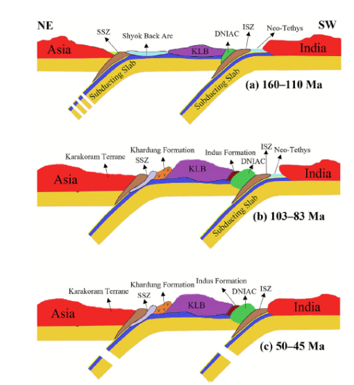
Fig: A 2-D geodynamic model for the evolution of the DNIAC-KLB compiled and modified after Ahmad et al. (2008). Abbreviations: KLB, Kohistan Ladakh Batholith; DNIAC, Dras Nidar Island Arc Complex; SSZ, Shyok Suture Zone; ISZ, Indus Suture Zone.
To understand how the arc evolved, the researchers studied the geochemical and isotopic characteristics of three major components: the pre-collisional Dras–Nidar Island Arc Complex (DNIAC), the pre- to syn-collisional Ladakh Batholith, which forms part of the larger Kohistan–Ladakh Batholith, and the post-collisional mafic dykes that cut through older rock formations. By comparing these different rock suites, the team was able to piece together a timeline of changing magmatic processes linked directly to shifts in tectonic behaviour.
Their analysis revealed that the magmatic evolution of the Ladakh region took place in three major phases—between 160–110 million years ago, 103–45 million years ago, and after 45 million years ago. Each of these phases carried distinct geochemical signatures, reflecting different stages in the interaction between the subducting slab, the overlying mantle wedge, and crustal material. In simple terms, the rocks preserve a record of how the deep Earth responded as tectonic plates moved, collided, and transformed the region.
During the earliest phase, the area is believed to have resembled a chain of volcanic islands rising out of the Neo-Tethys Ocean. Rocks from the Dras–Nidar Island Arc Complex preserve evidence of this stage. Their chemical signatures indicate that the magma during this time was derived mainly from the mantle, with only limited contribution from sediments carried downward by the subducting oceanic plate.
As tectonic convergence intensified, the geological system evolved. Deep underground, large granitic bodies known as the Ladakh Batholith began to form. These rocks carry stronger chemical evidence of continental material, suggesting that more sediments and fragments of crust were being recycled into the magma. This marked a major transition in the tectonic environment, as the collision between the Indian Plate and Eurasia began to reshape the entire arc system.
The approaching continental collision dramatically altered the chemistry of the magmas. The subducting plate started transporting larger volumes of sediment into the mantle, enriching the molten material and producing more complex geochemical signatures. Eventually, the Neo-Tethys Ocean closed, and the collision between India and Eurasia triggered the enormous uplift that would give rise to the Himalaya.
Even after the main collision, geological activity did not cease. Molten rock continued to rise through fractures in the crust, forming mafic dykes—dark, narrow sheets of volcanic rock that cut through older formations. These later magmas appear to have originated from a mantle source that had already been chemically enriched by earlier tectonic and magmatic processes, showing that the legacy of subduction continued well after the ocean itself had vanished.
What makes this study especially important is the method used by the scientists. By measuring rare trace elements and isotopes such as strontium and neodymium, the team was able to determine whether the magma came from deep mantle sources, recycled marine sediments, or continental crustal material. These isotopic signatures act almost like a geological time machine, allowing researchers to reconstruct events that took place millions of years ago with remarkable precision.
One of the important conclusions of the study is that sediment subduction played a much greater role in the Kohistan–Ladakh Batholith than in the earlier Dras–Nidar Island Arc Complex. This distinction helps scientists better understand how the tectonic environment changed through time as the region moved from oceanic subduction to full-scale continental collision.
The findings do more than explain the geological evolution of Ladakh. They also add a major piece to the broader puzzle of how mountain belts form, how continents collide, and how Earth’s crust is recycled over immense spans of time. In essence, the rocks of Ladakh are not just silent stones—they are archives of an ancient planet in motion, preserving the story of an ocean’s disappearance and the birth of a mountain realm.
The study has been published in Geoscience Frontiers.
Publication link: https://doi.org/10.1016/j.gsf.2026.102260
Source: PIB
You may also like
-
India Expands Quantum Research Push as 23 Institutions Get Labs, 100 More Under Review
-
Ancient Greenland Cooling Event Weakened Indian Monsoons 8,200 Years Ago, Study Finds
-
India Moves Toward Satellite Life-Extension Technology with Support for OrbitAID
-
Two New Chicks Mark Milestone in Great Indian Bustard Conservation Programme
-
Scientists Solve Long-Standing Puzzle of Heat Transport in Magnetic Semiconductors