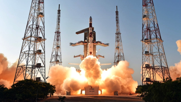
SRIHARIKOTA: With the successful launch of Cartosat-3 onboard PSLV-C47 on Wednesday morning, the Indian Space Research Organisation (Isro) has added one more to its constellation of remote sensing satellites that can map the earth with better accuracy. Isro has so far launched eight Cartosat satellites since 2005.
Along with Cartosat, PSLV, in its 49th flight, also placed 13 nanosatellites from the US in their orbits. With this, Isro has launched a total of 310 foreign satellites.
PSLV-C47 carrying Cartosat-3 and the nanosatellites lifted off from the second launch pad at Satish Dhawan Space Centre in Sriharikota at 9.28am, as scheduled. Around 17 minutes later, the rocket placed Cartosat-3 in a polar sun synchronous orbit. The nanosatellites were placed in their orbits in the next 10 minutes.
Isro chairman K Sivan said the launch vehicle precisely injected Cartosat-3 and 13 US nanosatellites into the desired orbits. “Cartosat-3 is the most complex and advanced earth observation satellite developed by Isro so far,” he said.
Cartosat-3 will circle the earth at a 509km altitude with an inclination of 97.5 degrees.
It is ISRO’s fifth launch in 2019, which included Chandrayaan-2 in July. It is the 21st flight of PSLV with an XL variant and the 74th mission from the Sriharikota spaceport.
Sivan said thirteen missions have been planned till March which includes six launch vehicle missions and seven satellite missions. “Our hands are full. The Isro team will rise to the occasion and meet every demand,” he said.
Director of U R Rao Satellite Centre (URSC) P Kunhikrishnan said Vikram processor developed by Isro had been integrated into the navigation system of the launch vehicle and used for the first time.
Cartosat-3
Cartosat-3, the ninth in the Cartosat series, is the first of the third-generation agile advanced earth observation satellites having high resolution imaging capability.
According to the space agency, the satellite shall address the increased user demands for large scale urban planning, rural resource and infrastructure development, coastal land use and land cover and others. The satellite is expected to help in military reconnaissance and mapping.
While Isro has not revealed the specifications of the imagers onboard the satellite, it is expected to have a spatial resolution of less than 30cm, which is far better than that of its predecessors — Cartosat-1 with 2.5m resolution and Cartosat-2 series with less than 1m resolution.
With a resolution of less than 30cm, the cameras onboard Cartosat-3 could capture images with greater accuracy that could help urban planners go as far as taking a headcount of pedestrians at a busy junction.
Source: TOI
Image Courtesy: The Weather Channel
You may also like
-
New Heat-Based Approach To Cancer Treatment Can Reduce Chemotherapy Doses
-
Scientists Take A Major Step Towards Unification Of Classical & Quantum Gravity
-
India Graphene Engineering and Innovation Centre (IGEIC) Under the Vision of Viksit Bharat@2047 Launched
-
New High-Performance Gas Sensor can Monitor Low Level Nitrogen Oxides Pollution
-
Antidepressant Drug can be Repurposed for Treating Breast Cancer
