NEW DELHI: The government and opposition are in a war of words over whether the IAF’s Mirage-2000 jets really hit the Jaish terror camp near Balakot with its Spice-2000 satellite image-fed laser-guided bombs around 3 am on February 26.
There are reports that due to a dense cloud cover on the day of the bombing, Indian spy satellites were not able to take images of the terror hub after the air strike.
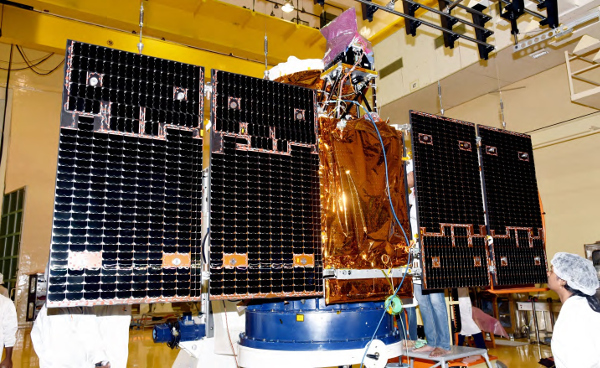
However, Isro-made satellite Risat-2, which is currently under the control of National Technical Research Organisation (NTRO), has the capability to penetrate through a cloud cover and can take photos of the earth even at night.
The spy satellite with its Israel-made X-band synethic aperture radar can zoom up to a resolution of 1 metre (means it can distinguish between two objects separated by 1 m distance). “The reconnaissance satellite can take images of a building or an object on the earth at least 2 to 3 times a day,” a source in Isro said. If the spy satellite can take images of a spot at least three times in 24 hours while orbiting the earth, it could have been used to capture the images of the devastation at the JeM camp due to the air strike.
After the 26/11 terror attacks in Mumbai in 2008, Risat-2 satellite programme took priority over Risat-1 because of the advanced radar system and was launched in April 20, 2009 to boost surveillance capabilities of security forces. From 536km altitude, the satellite monitors Indian borders 24×7 and helps security agencies keep an eye on infiltrators and anti-terrorist operations.
SPY-SAT-IMAGE
India has another series of advanced remote sensing satellites Cartosat-2 which security agencies use to keep an eye on terror camps in POK and other parts of Pakistan. These satellites too have night surveillance capability. Cartosat-2’s high-resolution panchromatic (PAN) camera, which can take black and white pictures of the earth and cover swath of 9.6 km, has a resolution of 0.5 metre. However, the satellites cannot penetrate a cloud cover. It is said the Army used images from the earlier Cartosat series to plan the surgical strikes on terror launchpads in POK in 2016.
According to the Isro source, “Out of the total 47 operational satellites, India currently has six-eight satellites which are entirely used for military purpose. Besides Risat-2, there are four Cartosat-2 series satellites (2C, 2D, 2E, 2F) and Gsat-29 satellite.” The space agency has also launched a defence imaging satellite, Microsat R, for DRDO in January and is going to launch another satellite electromagnetic intelligence satellite EMISAT for the organisation in the last week of this month. While Microsat-R satellite can capture images at night, EMISAT has the capability to detect radars and microwave signals.
Besides dedicated military satellites, Isro has also launched communication satellites Gsat-7 and Gsat-7a for navy and air force. Gsat-7A, launched last November, boosted drone operations as it is helping the IAF upgrade from existing ground control stations to satellite-control of military UAVs.
There are some satellites which have dual use. For example HysIS (hyper-spectral imaging satellite), which was launched in last November, can see through soil up to a few centimeters and detect landmines and IEDs. However, it is also used for a range of civil applications like in agriculture and forestry.
Source: ToI
Image Courtesy: SpaceFlight101
You may also like
-
IAF Aircraft Set Course For Exercise Eastern Bridge VII At Oman
-
IAF Set To Host The Indian Defence Aviation Exposition-II At Jodhpur
-
Defence Secretary to co-chair 5th India-Philippines Joint Defence Cooperation Committee meeting in Manila
-
Simultaneous Launch Of ‘malpe And Mulki’, Fourth And Fifth Ships Of Asw Swc (Csl) Project
-
Aatmanirbharta in Defence: MoD signs Contract with HAL for 240 AL-31FP Aero Engines for Su-30MKI Aircraft
