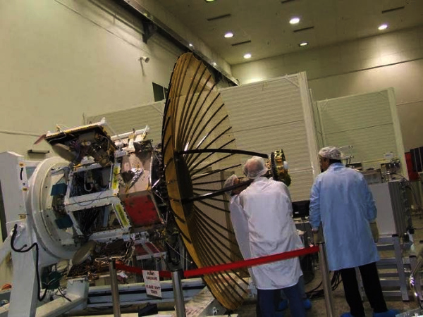
Among the significant but low-profile Indian space missions of 2019 were the launches of two Radar Imaging Satellites, RISAT-2B and RISAT-2BR1.
Earth observation (EO) satellites that use a radar, thus giving them all-weather vision, have been around since 1978. India entered this field in 2009 with RISAT-2 using an Israeli built payload. Ten years on, the Indian Space Research Organisation (ISRO) has now increased to four its tally of SAR, or synthetic aperture radar, satellites.
And the last two were placed in space in 2019, in a span of just seven months.
Indications from ISRO are that at least four more will follow quickly in a year or so, with the fifth one, RISAT-2BR2, likely to be announced fairly soon.
India’s efforts to add to its complement of EO satellites coincides with a global rush — by public and even more so private space entities — to put up SAR satellites in low-earth orbits.
While there was a three-year gap between the first and second Indian SAR satellites (RISAT-2 in 2009 and RISAT-1 in 2012), followed by a seven-year lull, 2019 marked an acceleration in the pace of additions with the country’s RISAT tally likely to reach seven — including one or two replacements — in the near future.
RISATs have strong strategic, read military, utility.
The X band radars of 2B and 2BR1 are said to be useful for military surveillance across our borders.
When ISRO resumed this earth observation category in May by launching RISAT-2B, a senior scientist had said that they had assembled it in a record 15 months (it would normally have taken the agency about four years to get these complex satellites ready for space).
Why does a country need so many SAR satellites and so fast? While optical imaging based EO satellites capture colour images of patches of earth from 500-600 km overhead, they can do so only when there is sunlight and no cloud or rain. In contrast, a SAR satellite works 24/7, round-the-year in any weather. It bounces microwaves off the earth to sense in detail, the size, shape, height and changes in objects or terrains. The Indian military’s border strikes in darkness such as the February Balakot attack could potentially have benefited from such inputs.
Based on their frequency bands (X, C, L or S) SAR satellites suit different applications. They can exactly size farms, assess soil moisture, predict harvests, gauge terrain features and infrastructure, appraise water bodies. Above all, they can detect the movement of people on land or ships on sea, clearly indicating the size of objects and structures. Which makes them ideal for border and maritime surveillance.
SAR data are also handy for authorities when it comes to deciding crop insurance, compensation, assessing the damage in areas hit by floods and other calamities.
A ‘SAR up’ race
Radar based EO, a government business with military interest until a couple of years back (and dominated by Canada’s RADARSAT for many years) is “now a new kid on the emerging commercial EO (earth observation) block’’, says space entrepreneur and policy professional Narayan Prasad, founder-COO of space start-up Satsearch based in India and Europe.
Currently, about 9-12 start-ups with a clear intent to establish SAR constellations can be counted. Many more, he says, are still in stealth mode. Each one is flooding the lower skies with constellations of 100-kg class micro satellites, offering unprecedented quick revisits and fair views of the ground below to mainly defence agencies.
If all of the announced ‘eyes in the sky’ come up, there could be about 100 commercial micro SAR satellites in the next 3-5 years: a South African space advisory company has called this trend ‘SAR wars’.
Indian bite
A private Indian ‘SAR sat’ may be a far cry but India is tasting the pie in its own way. California start-up Capella Space, which is launching 36 micro SAR sats and has won a U.S. government contract, recently named Remote Sensing Instruments of Hyderabad as its South Asia partner for radar imaging data sales.
Quite a few SAR satellite ventures have sought to ride to space on the Indian PSLV. Israel, one of the early SAR birds, flew TecSAR to space on a PSLV in January 2008. (That satellite became the model for RISAT-2, ISRO’s first, which had the Israeli core payload.)
In the latest launch on December 11, Japanese SAR fleet aspirant iQPS Inc. launched its first satellite, QPS-SAR1, on the PSLV. In January 2018, ICEYE, the Finland-based private micro SAR pioneer, flew the first of its 18 satellites on the PSLV. U.K.’s SSTL has also used the Indian rocket for its NovaSAR.
As of November 2018, there were 52 radar imaging satellites of different agencies, says U.K.-based EO consultancy company Pixalytics Ltd. citing the annual update of the Union of Concerned Scientists. (In the previous year there were 49 radar satellites out of 684 EO satellites.)
This is still a small percentage in the global total of 710 EO satellites, but the scene is gradually changing.
Source: The Hindu
Image Courtesy:Satnews
You may also like
-
New Heat-Based Approach To Cancer Treatment Can Reduce Chemotherapy Doses
-
Scientists Take A Major Step Towards Unification Of Classical & Quantum Gravity
-
India Graphene Engineering and Innovation Centre (IGEIC) Under the Vision of Viksit Bharat@2047 Launched
-
New High-Performance Gas Sensor can Monitor Low Level Nitrogen Oxides Pollution
-
Antidepressant Drug can be Repurposed for Treating Breast Cancer
